Filters: Tags: Leadville (X)
31 results (16ms)|
Filters
Contacts
(Less)
|
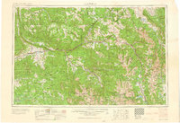
This data set contains imagery from the National Agriculture Imagery Program (NAIP). The NAIP program is administered by USDA FSA and has been established to support two main FSA strategic goals centered on agricultural production. These are, increase stewardship of America's natural resources while enhancing the environment, and to ensure commodities are procured and distributed effectively and efficiently to increase food security. The NAIP program supports these goals by acquiring and providing ortho imagery that has been collected during the agricultural growing season in the U.S. The NAIP ortho imagery is tailored to meet FSA requirements and is a fundamental tool used to support FSA farm and conservation programs....
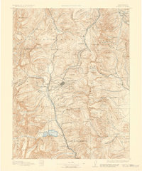
The Leadville North 7.5' quadrangle lies at the northern end of the Upper Arkansas Valley, where the Continental Divide at Tennessee Pass creates a low drainage divide between the Colorado and Arkansas River watersheds. In the eastern half of the quadrangle, the Paleozoic sedimentary section dips generally 20–30 degrees east. At Tennessee Pass and Missouri Hill, the core of the Sawatch anticlinorium is mapped as displaying a tight hanging-wall syncline and foot-wall anticline within the basement-cored structure. High-angle, west-dipping, Neogene normal faults cut the eastern margin of the broad, Sawatch anticlinorium. Minor displacements along high-angle, east- and west-dipping Laramide reverse faults occurred in...
Core Research Center, core D185, from well operated by MONSANTO OILRaw Properties from download, web scrape, MapServer, and Macrostrat API{"Lib Num": "D185", "API Num": "0200120283", "Operator": "MONSANTO OIL", "Well Name": "138-6 NAVAJO TRACT", "Field": "DRY MESA", "State": "AZ", "County": "APACHE", "Type": "SLABBED", "Photos": "F", "Thin Sec": "F", "Analysis": "F", "Latitude": "36.90146643", "Longitude": "-109.311004", "coordinates_geohash": "9wd3btdnsgzv", "Source": "FROM STATE RECORDS", "Security Flag": "NO SPECIAL RESTRICTIONS", "crc_collection_name": "core", "sb_parent_id": "4f4e49dae4b07f02db5e0486", "intervals": [{"Formation": "LEADVILLE", "Age": "MISS", "Min Depth": "5280", "Max Depth": "5300"}], "crcwc_url":...
Categories: Physical Item;
Tags: LEADVILLE,
MISS,
Morrison Formation,
Morrison Formation,
Oxfordian - Tithonian,
USGS Historical Quadrangle in GeoPDF.
This data set contains imagery from the National Agriculture Imagery Program (NAIP). The NAIP program is administered by USDA FSA and has been established to support two main FSA strategic goals centered on agricultural production. These are, increase stewardship of America's natural resources while enhancing the environment, and to ensure commodities are procured and distributed effectively and efficiently to increase food security. The NAIP program supports these goals by acquiring and providing ortho imagery that has been collected during the agricultural growing season in the U.S. The NAIP ortho imagery is tailored to meet FSA requirements and is a fundamental tool used to support FSA farm and conservation programs....
Core Research Center, core A488, from well operated by ASHLAND OILRaw Properties from download, web scrape, MapServer, and Macrostrat API{"Lib Num": "A488", "API Num": "3004521816", "Operator": "ASHLAND OIL", "Well Name": "2 NAVAJO 5", "Field": "BARKER CREEK", "State": "NM", "County": "SAN JUAN", "Type": "SLABBED", "Photos": "T", "Thin Sec": "T", "Analysis": "T", "Latitude": "36.515376", "Longitude": "-108.89657", "coordinates_geohash": "9w6x9zrvqp2n", "Source": "FROM STATE RECORDS", "Security Flag": "NO SPECIAL RESTRICTIONS", "crc_collection_name": "core", "sb_parent_id": "4f4e49dae4b07f02db5e0486", "intervals": [{"Formation": "LEADVILLE", "Age": "MISS", "Min Depth": "6018", "Max Depth": "6037"}, {"Formation":...
Categories: Physical Item;
Tags: BLACKWATER CREEK,
Cenomanian - Turonian,
LEADVILLE,
LEADVILLE,
MISS,
Core Research Center, core T440, from well operated by MITCHELL ENERGYRaw Properties from download, web scrape, MapServer, and Macrostrat API{"Lib Num": "T440", "API Num": "0510309463", "Operator": "MITCHELL ENERGY", "Well Name": "3-13-104 RABBIT MOUNTAIN UNIT", "Field": "HELL'S HOLE", "State": "CO", "County": "RIO BLANCO", "Type": "FULL", "Photos": "T", "Thin Sec": "F", "Analysis": "T", "Latitude": "39.869608", "Longitude": "-109.021138", "coordinates_geohash": "9x46z4j1r3ee", "Source": "FROM STATE RECORDS", "Security Flag": "NO SPECIAL RESTRICTIONS", "crc_collection_name": "core", "sb_parent_id": "4f4e49dae4b07f02db5e0486", "intervals": [{"Formation": "LEADVILLE", "Age": "MISS", "Min Depth": "11400", "Max Depth":...
Categories: Physical Item;
Tags: Cretaceous,
LEADVILLE,
MISS,
Mesaverde Group,
Upper part of the Mesaverde Group,
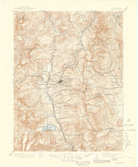
The Homestake Reservoir 7.5' quadrangle lies at the northwestern end of the Upper Arkansas Valley, and headwaters of the Arkansas River, and the Roaring Fork, Fryingpan, and Eagle Rivers of the Colorado River system. The quadrangle lies within tectonic provinces of the 1.4 Ga Picuris Orogeny, the late Paleozoic Ancestral Rockies, Late Cretaceous-Paleocene Laramide orogeny, Oligocene to Miocene, and Pliocene?, volcanism, and Miocene to the present Rio Grande rift extensional tectonics. In the eastern half of the quadrangle, high-angle, east-dipping, Neogene normal faults displace Proterozoic rocks, and locally Mio-Pliocene? volcanic rocks. Many quartz veins and hydrothermally altered zones are exposed along the eastern...
Categories: Data;
Types: Downloadable,
GeoTIFF,
Map Service,
Raster;
Tags: 10Be, 26Al,
10th Mountain Division Hut,
Bald Eagle Mountain,
Bear Lake,
Brady Lake,

USGS Historical Quadrangle in GeoPDF.
This data set contains imagery from the National Agriculture Imagery Program (NAIP). The NAIP program is administered by USDA FSA and has been established to support two main FSA strategic goals centered on agricultural production. These are, increase stewardship of America's natural resources while enhancing the environment, and to ensure commodities are procured and distributed effectively and efficiently to increase food security. The NAIP program supports these goals by acquiring and providing ortho imagery that has been collected during the agricultural growing season in the U.S. The NAIP ortho imagery is tailored to meet FSA requirements and is a fundamental tool used to support FSA farm and conservation programs....

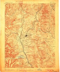
USGS Historical Quadrangle in GeoPDF.
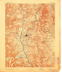
USGS Historical Quadrangle in GeoPDF.

USGS Historical Quadrangle in GeoPDF.
USGS Historical Quadrangle in GeoPDF.
USGS Historical Quadrangle in GeoPDF.
Core Research Center, core D703, from well operated by APACHE CORPORATIONRaw Properties from download, web scrape, MapServer, and Macrostrat API{"Lib Num": "D703", "API Num": "0511306044", "Operator": "APACHE CORPORATION", "Well Name": "22-1 FEDERAL NICK WASH", "Field": "NICHOLAS WASH", "State": "CO", "County": "SAN MIGUEL", "Type": "SLABBED", "Photos": "F", "Thin Sec": "T", "Analysis": "T", "Latitude": "38.064006", "Longitude": "-108.850265", "coordinates_geohash": "9wf8e13duvp8", "Source": "FROM STATE RECORDS", "Security Flag": "NO SPECIAL RESTRICTIONS", "crc_collection_name": "core", "sb_parent_id": "4f4e49dae4b07f02db5e0486", "intervals": [{"Formation": "LEADVILLE", "Age": "MISS", "Min Depth": "8094", "Max Depth":...
USGS Historical Quadrangle in GeoPDF.

USGS Historical Quadrangle in GeoPDF.

USGS Historical Quadrangle in GeoPDF.
USGS Historical Quadrangle in GeoPDF.
|

|
