Filters: Tags: Livestock (X)
45 results (23ms)|
Filters
Contacts
(Less)
|
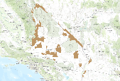
This is an aggregate dataset for the DRECP 12 km buffer region, depicting the geographic boundaries of Grazing Allotments within BLM managed public lands. An allotment is an area of land designated and managed for grazing of livestock (43 CFR 4100.0-5). An allotment may include private, state, and public lands under the jurisdiction of the Bureau of Land Management and/or other federal agencies. An allotment may be subdivided into pastures. Range improvement projects are not depicted within this dataset.
This dataset consists of a series of rasters covering the conterminous United States. Each raster is a one kilometer (km) grid for 18 selected Census of Agriculture statistics mapped to land use pixels for the time period 1950 to 2012. A supplemental set of 9 statistics mapped at the entire county level are also provided as 1-km rasters. The rasters are posted as ArcGIS grids. The statistics represent values for crops, livestock, irrigation, fertilizer, and manure usage. Most statistics are mapped for all 14 Census of Agriculture reporting years in that time frame: 1950, 1954, 1959, 1964, 1969, 1974, 1978, 1982, 1987, 1992, 1997, 2002, 2007, and 2012.
Categories: Data;
Types: Citation;
Tags: Census of Agriculture,
Conterminous U.S.,
Cropland,
Crops,
Dasymetric mapping,
Annotated bibliography of grazing effects on amphibians and their habitats (ver. 2.0, February 2022)
This database contains literature citations and associated summaries pertaining to livestock grazing effects on amphibians and their habitats, with an emphasis on the Oregon spotted frog (Rana pretiosa) and other listed/sensitive wetland-breeding amphibians in the western United States. This is not meant to be an exhaustive list, nor did we perform a systematic meta-analysis; rather, literature records were included based on topical relevance. *HINT: If you are looking for the database SEARCH TOOL, scroll down to 'Attached Files' and download 'Annotated_bibliography_with_search_tool.accdb.' Open the database file to enter the search form.* This data release supersedes Rowe, J.C., Pearl, C.A., Adams, M.J., and McCreary,...
Categories: Data;
Tags: Aquatic Biology,
Ecology,
Land Use Change,
USGS Science Data Catalog (SDC),
Wildlife Biology,
In 2006/2007 the Adobetown Herd Management Area (HMA) was rounded up to bring the HMA to its Appropriate Management Level (AML). Given that the HMA is now at AML, a suite of projects have been identified that will improve wildhorse and livestock distribution, rangeland health, and reduce wildhorse movement outside the HMA. The majority of livestock use in this area includes winter sheep, and water development is lacking throughout the HMA. Six miles of pipeline, a number of short pipelines, troughs and supplies for several water wells are proposed. An existing network of pipelines and troughs could be rehabilitated with the purchase and installation of a large solar pump. Four spring developments and small pits...
Categories: Project;
Types: ScienceBase Project;
Tags: Habitat,
habitat conservation project,
livestock,
sagebrush steppe,
water development,

The SARP Flow Alteration Assessment provides a regional characterization of the distribution and risk of flow regime impairment of streams and rivers by anthropogenic sources at the NHD+ segment scale. This map illustrates the cumulative risk of flow alteration (RFA) from surface water use for thermopower generation in Oklahoma.  Water use is based on state permits for surface water withdrawals and returns.  The risk is based on the volume of water used monthly in the drainage area relative to the monthly volume of flow.  Risk of Flow Alteration categories:  ZERO     - 0% mean monthly flow depletion,  LOW      - > 0-10%,  MEDIUM - > 10-20%,  HIGH      - >20-100%, and  PROVISIONAL...

The SARP Flow Alteration Assessment provides a regional characterization of the distribution and risk of flow regime impairment of streams and rivers by anthropogenic sources at the NHD+ segment scale. This map illustrates the cumulative risk of flow alteration (RFA) from surface water use industrial water use in Texas and Oklahoma.  Water use is based on state permits for surface water withdrawals and returns.  The risk is based on the volume of water used monthly in the drainage area relative to the monthly volume of flow.  Risk of Flow Alteration categories:  ZERO     - 0% mean monthly flow depletion,  LOW      - > 0-10%,  MEDIUM - > 10-20%,  HIGH      - >20-100%, and Â...
This product provides tabular estimates of kilograms of nitrogen and phosphorus from a) fertilizer, and b) manure, for counties in the conterminous United States for the period 1950-2017. Data are generated for approximate five-year periods over the time, coinciding with U.S. Department of Agriculture Census of Agriculture census years. This data release also includes a model archive suitable for recreating the 2017 fertilizer estimates.
This product provides tabular data from the U.S. Department of Agriculture (USDA) Census of Agriculture for selected items for the period 1950-2017 for counties in the conterminous United States. Data from 1950-2012 are taken from LaMotte (2015) and 2017 data are retrieved from the USDA QuickStats online tool. Data which are withheld in the Census of Agriculture are filled with estimates. The data include crop production values for 12 commodities (for example, corn in bushels), land use values for 7 land use types (for example, acres of total cropland), and 9 values for livestock types (for example, number of hogs and pigs). The data are largely intended as a 2017 update to the LaMotte dataset for items of research...
This is a spatially-explicit state-and-transition simulation model of rangeland vegetation dynamics in southwest South Dakota. It was co-designed with resource management partners to support scenario planning for climate change adaptation. The study site encompasses part of multiple jurisdictions, including Badlands National Park, Buffalo Gap National Grasslands, and Pine Ridge Indian Reservation. The model represents key vegetation types, grazing, exotic plants, fire, and the effects of climate and management on rangeland productivity and composition (i.e., distribution of ecological community phases). See Miller et al. (2017) for further details. The model was built using the ST-Sim software platform (www.apexrms.com/stsm)....
Categories: Data;
Types: Citation;
Tags: Badlands National Park,
Bison,
Buffalo Gap National Grassland,
Cattle,
Climate change,
Content Changing aspen distribution in response to climate change and fire is a major focus of biodiversity conservation, yet little is known about the potential response of aspen to these two driving forces along topoclimatic gradients. Objective This study is set to evaluate how aspen distribution might shift in response to different climate-fire scenarios in a semi-arid montane landscape, and quantify the influence of fire regime along topoclimatic gradients. Methods We used a novel integration of a forest landscape succession and disturbance model (LANDIS-II) with a fine-scale climatic water deficit approach to simulate dynamics of aspen and associated conifer and shrub species over the next 150 years under...
Categories: Data,
Publication;
Types: Citation;
Tags: EARTH SCIENCE > LAND SURFACE > LANDSCAPE,
LCC Network Science Catalog,
Report,
aspen woodland,
biota,

The SARP Flow Alteration Assessment provides a regional characterization of the distribution and risk of flow regime impairment of streams and rivers by anthropogenic sources at the NHD+ segment scale. This map illustrates the local risk of flow alteration (RFA) from surface water use by water use sector for Texas and Oklahoma.  Water use is based on state permits for surface water withdrawals and returns.  The risk is based on the volume of water used monthly in the drainage area relative to the monthly volume of flow.  Risk of Flow Alteration categories:  ZERO     - 0% mean monthly flow depletion,  LOW      - > 0-10%,  MEDIUM - > 10-20%,  HIGH      - >20-100%, and  PROVISIONAL...
Effects of long-term cattle exclosure on vegetation and rodents at a desertified arid grassland site
Arid grasslands are often presumed to exist in one of two alternate stable states: grassland or desertified shrubland. While the conversion to shrubland can occur rather rapidly following intense overgrazing, the recovery of perennial grasses is often presumed to be difficult or impossible even with livestock removal. We examined vegetation and rodent communities at a desertified shrubland site from which livestock had been removed for more than four decades. Total shrub cover was similar but differed in composition across the grazing fence. Larrea tridentata had significantly higher cover outside while Parthenium incanum had significantly higher cover inside the fence. Basal perennial grass cover was significantly...
Categories: Publication;
Types: Citation,
Journal Citation;
Tags: Alternate stable state,
Arizona,
Journal of Arid Environments,
Livestock,
Overgrazing,
FY2017Removal of livestock grazing is a common prescription to promote ecosystem recovery after wildfire (and subsequent emergency site rehabilitation efforts). Ecosystem recovery is typically considered from a terrestrial perspective, but wildfire and grazing can strongly influence aquatic ecosystems as well, especially smaller and fragmented stream networks, which are prevalent in the Great Basin (Minshall et al. 1989[1]; Dunham et al. 2003[2]; Luce et al. 2012[3]). Understanding these influences is essential for managing fire and grazing. Examples include identifying timeframes for resuming livestock grazing following wildfire, and the interactions between livestock grazing, fuels, and recovery of stream-side...
FY2014This projects main goals are to assess the effects of grazing by feral horses and livestock on Greater Sage-grouse demography and habitats. The Sheldon-Hart Mountain National Wildlife Refuge Complex and adjacent lands managed by the Bureau of Land Management provide the unique opportunity to assess sage-grouse populations free of feral horses and livestock grazing, populations that only have feral horses, as well as populations that coincide with both livestock grazing and feral horses. The project team will:1)Use historical sage-grouse data collected from Hart Mountain before and immediately after livestock were removed in the early 1990s, and historical data from Sheldon before the irruption of feral horses...
Categories: Data,
Project;
Types: Map Service,
OGC WFS Layer,
OGC WMS Layer,
OGC WMS Service;
Tags: Conservation Planning,
Data Acquisition and Development,
Datasets/Database,
Federal resource managers,
Grazing,
Data can be accessed through a map service (select one of the options in the grey bar above the inset map) or viewed in the BLM's GeoCommunicator interactive map.
Categories: Data,
Web Site;
Types: ArcGIS REST Map Service,
Map Service;
Tags: Allotment,
BLM,
GRA,
Grazing,
Livestock,
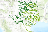
The SARP Flow Alteration Assessment provides a regional characterization of the distribution and risk of flow regime impairment of streams and rivers by anthropogenic sources at the NHD+ segment scale. This map illustrates the cumulative risk of flow alteration (RFA) from surface water use for mining in Texas and Oklahoma.  Water use is based on state permits for surface water withdrawals and returns.  The risk is based on the volume of water used monthly in the drainage area relative to the monthly volume of flow.  Risk of Flow Alteration categories:  ZERO     - 0% mean monthly flow depletion,  LOW      - > 0-10%,  MEDIUM - > 10-20%,  HIGH      - >20-100%, and  PROVISIONAL...

The SARP Flow Alteration Assessment provides a regional characterization of the distribution and risk of flow regime impairment of streams and rivers by anthropogenic sources at the NHD+ segment scale. This map illustrates the cumulative risk of flow alteration (RFA) from surface water use for domestic and livestock in Texas and Oklahoma.  Water use is based on state permits for surface water withdrawals and returns.  The risk is based on the volume of water used monthly in the drainage area relative to the monthly volume of flow.  Risk of Flow Alteration categories:  ZERO     - 0% mean monthly flow depletion,  LOW      - > 0-10%,  MEDIUM - > 10-20%,  HIGH      - >20-100%,...

This dataset depicts livestock grazing range allotments on the Siskiyou National Forest. Each allotment is a designated area of land available for livestock grazing.
Project Synopsis: habitat conditions for both livestock and wildlife are less than desired due, in part, to past management practices on the ranch and inability to better control current cattle grazing location and timing. Plans are to provide water (successful water well drilled in 2011) and fencing for grazing management, habitat improvements on mule deer winter range including invasive plant species (juniper and cheatgrass) control, and riparian improvements in Wood Draw to remove invasive juniper and control noxious weeds including musk thistle and leafy spurge.
Categories: Project;
Types: ScienceBase Project;
Tags: Habitat,
cheatgrass,
habitat conservation project,
invasive species,
juniper,
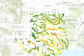
The SARP Flow Alteration Assessment provides a regional characterization of the distribution and risk of flow regime impairment of streams and rivers by anthropogenic sources at the NHD+ segment scale. This map illustrates the cumulative risk of flow alteration (RFA) from surface water use by water use sector for Texas and Oklahoma.  Water use is based on state permits for surface water withdrawals and returns.  The risk is based on the volume of water used monthly in the drainage area relative to the monthly volume of flow.Risk of Flow Alteration categories: ZERO     - 0% mean monthly flow depletion,  LOW      - > 0-10%,  MEDIUM - > 10-20%,  HIGH      - >20-100%, and PROVISIONAL...
|

|
