Filters: Tags: MOUNT BAKER (X)
9 results (119ms)|
Filters
Date Range
Extensions Types Contacts
Categories Tag Types Tag Schemes |
This data set contains imagery from the National Agriculture Imagery Program (NAIP). The NAIP program is administered by USDA FSA and has been established to support two main FSA strategic goals centered on agricultural production. These are, increase stewardship of America's natural resources while enhancing the environment, and to ensure commodities are procured and distributed effectively and efficiently to increase food security. The NAIP program supports these goals by acquiring and providing ortho imagery that has been collected during the agricultural growing season in the U.S. The NAIP ortho imagery is tailored to meet FSA requirements and is a fundamental tool used to support FSA farm and conservation programs....
This data set contains imagery from the National Agriculture Imagery Program (NAIP). The NAIP program is administered by USDA FSA and has been established to support two main FSA strategic goals centered on agricultural production. These are, increase stewardship of America's natural resources while enhancing the environment, and to ensure commodities are procured and distributed effectively and efficiently to increase food security. The NAIP program supports these goals by acquiring and providing ortho imagery that has been collected during the agricultural growing season in the U.S. The NAIP ortho imagery is tailored to meet FSA requirements and is a fundamental tool used to support FSA farm and conservation programs....
This data set contains imagery from the National Agriculture Imagery Program (NAIP). The NAIP program is administered by USDA FSA and has been established to support two main FSA strategic goals centered on agricultural production. These are, increase stewardship of America's natural resources while enhancing the environment, and to ensure commodities are procured and distributed effectively and efficiently to increase food security. The NAIP program supports these goals by acquiring and providing ortho imagery that has been collected during the agricultural growing season in the U.S. The NAIP ortho imagery is tailored to meet FSA requirements and is a fundamental tool used to support FSA farm and conservation programs....
Hydrothermally altered rocks, particularly if water saturated, can weaken stratovolcanoes, thereby increasing the potential for catastrophic sector collapses that can lead to far-traveled, destructive debris flows, which are the largest volcanic hazards for Mount Adams and Mount Baker. Evaluating the hazards associated with such alteration is difficult because much of the alteration is obscured by ice and its depth extent is unknown. Intense hydrothermal alteration significantly reduces the resistivity and magnetization of volcanic rock and therefore hydrothermally altered rocks are identified with helicopter electromagnetic and magnetic measurements at Mount Baker and Mount Adams. High resolution magnetic and electromagnetic...
Categories: Data;
Types: Citation,
Downloadable,
Map Service,
OGC WFS Layer,
OGC WMS Layer,
Shapefile;
Tags: CGGSC,
Crustal Geophysics and Geochemistry Science Center,
Fugro Airborne Surveys,
Mount Baker,
Washington,
Elemental compositions are reported for the fine fraction of surface sediments from Bellingham Bay (June 2017 and March 2019) and in the fine fraction of streambank sediment from the Nooksack River (September 2017, March 2019, September 2019), Squalicum Creek (March and September 2019), Whatcom Creek (March and September 2019), and Padden Creek (March and September 2019). Major oxide percentages are reported in Nooksack River fine sediment collected in September 2017. Ancillary data for sediment collected during 2017 and 2019 from Bellingham Bay, Nooksack River, and small creeks include: percent weights of gravel, sand, and fines; total organic carbon content (TOC); carbonate content (CaCO3); ratios of stable carbon...
Categories: Data;
Tags: Bellingham Bay,
CMHRP,
Chuckanut Bay,
Coastal and Marine Hazards and Resources Program,
Geochemistry,
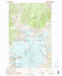
USGS Historical Quadrangle in GeoPDF.
This data set contains imagery from the National Agriculture Imagery Program (NAIP). The NAIP program is administered by USDA FSA and has been established to support two main FSA strategic goals centered on agricultural production. These are, increase stewardship of America's natural resources while enhancing the environment, and to ensure commodities are procured and distributed effectively and efficiently to increase food security. The NAIP program supports these goals by acquiring and providing ortho imagery that has been collected during the agricultural growing season in the U.S. The NAIP ortho imagery is tailored to meet FSA requirements and is a fundamental tool used to support FSA farm and conservation programs....

USGS Historical Quadrangle in GeoPDF.
Snow and ice-covered Mount Baker in northern Washington, is the highest peak in the North Cascades (3,286 meters or 10,781 feet) and the northernmost volcano in the conterminous United States. It is the only U.S. volcano in the Cascade Range that has been affected by both alpine and continental glaciation. The stratovolcano is composed mainly of andesite lava flows and breccias formed prior to the most recent major glaciation (Fraser Glaciation), which occurred between about 25,000 and 10,000 years ago. The most recent major eruption at Mount Baker (6,700 years ago) was accompanied by a major flank-collapse event that caused lahars to rush down the Nooksack River and then eastward into Baker Lake. In 1975-76, Sherman...
|

|
