Filters: Tags: Marine mammals (X)
64 results (19ms)|
Filters
|
This report presents updated information about subsistence uses of fish, wildlife, and plant resources in 5 communities of southcentral Alaska -- Iliamna, Newhalen, Nondalton, Pedro Bay, and Port Alsworth. The Division of Subsistence of the Alaska Department of Fish and Game conducted the study in collaboration with the National Park Service and Stephen R. Braund & Associates. The Pebble Project is a proposed open pit mine located 18 miles to the northwest of Iliamna and 18 miles southwest of Nondalton. The potential development of the mine requires updated baseline information about subsistence harvests and uses. Information was collected through systematic household surveys and mapping interviews. Scoping meetings...
This report presents updated information about subsistence uses of fish, wildlife, and plant resources in 5 communities of southcentral Alaska -- Iliamna, Newhalen, Nondalton, Pedro Bay, and Port Alsworth. The Division of Subsistence of the Alaska Department of Fish and Game conducted the study in collaboration with the National Park Service and Stephen R. Braund & Associates. The Pebble Project is a proposed open pit mine located 18 miles to the northwest of Iliamna and 18 miles southwest of Nondalton. The potential development of the mine requires updated baseline information about subsistence harvests and uses. Information was collected through systematic household surveys and mapping interviews. Scoping meetings...
This report presents updated information about subsistence uses of fish, wildlife, and plant resources in 5 communities of southcentral Alaska -- Iliamna, Newhalen, Nondalton, Pedro Bay, and Port Alsworth. The Division of Subsistence of the Alaska Department of Fish and Game conducted the study in collaboration with the National Park Service and Stephen R. Braund & Associates. The Pebble Project is a proposed open pit mine located 18 miles to the northwest of Iliamna and 18 miles southwest of Nondalton. The potential development of the mine requires updated baseline information about subsistence harvests and uses. Information was collected through systematic household surveys and mapping interviews. Scoping meetings...
This report presents updated information about subsistence uses of fish, wildlife, and plant resources in 5 communities of southcentral Alaska -- Iliamna, Newhalen, Nondalton, Pedro Bay, and Port Alsworth. The Division of Subsistence of the Alaska Department of Fish and Game conducted the study in collaboration with the National Park Service and Stephen R. Braund & Associates. The Pebble Project is a proposed open pit mine located 18 miles to the northwest of Iliamna and 18 miles southwest of Nondalton. The potential development of the mine requires updated baseline information about subsistence harvests and uses. Information was collected through systematic household surveys and mapping interviews. Scoping meetings...
This report presents updated information about subsistence uses of fish, wildlife, and plant resources in 5 communities of southcentral Alaska - Igiugig, Kokhanok, Koliganek, Levelock, and New Stuyahok. The Division of Subsistence of the Alaska Department of Fish and Game conducted the study in collaboration with Stephen R. Braund & Associates. Phase I of this study took place in the communities of Iliamna, Newhalen, Nondalton, Pedro Bay, and Port Alsworth in 2005, to document subsistence uses and harvests and demographic and other economic data for the study year of 2004 (Fall et al. 2006). This report documents findings from phase II which expanded the study to 5 additional communities within the watersheds that...
These data are estimates of den emergence date, den site departure dates, and duration at den sites as well as post-emergence observations for female polar bears sampled in the southern Beaufort Sea subpopulation 1985-2016 and the Chukchi Sea subpopulation 2008-2017. The data were used to better understand the importance of time spent at the den site post-emergence. Emergence dates and departure dates were determined using collar temperature sensor data.
This dataset includes measures collected on polar bears captured in the Chukchi and Beaufort Seas, 1981-2017 by the U.S. Geological Survey and U.S. Fish and Wildlife Service. Data collected include body length, body mass, axillary girth, skull width and tail lengths. Bears were also aged as described in the methods. For some bears, an adipose tissue sample was collected and percent lipid content was measured, percent body fat was measured via bioelectrical impedance analysis, and/or recent feeding behavior was assessed via gut palpitation or blood urea and creatinine levels, all of which are further described in the methods.
Tracklines and associated observations were mapped and analyzed using ArcMap (ESRI, Redlands, CA). GPS data were recorded in NAD27 map datum and projected to an USGS Albers Equal Area Conic map projection for presentation and subsequent density analyses. Concatenated GPS and observation data were then used to generate point and line coverages in ArcMap (ESRI, Redlands, CA). We designed a custom analytic tool using ArcMap Model Builder that allows for the construction and export of user-specified and effort-adjusted spatial binning of species observations along continuous trackines. For the purposes of this report, we calculated seabird density estimates and marine mammal counts along continuous 3.0-kilometer and...
Categories: Data;
Types: Downloadable,
Map Service,
OGC WFS Layer,
OGC WMS Layer,
Shapefile;
Tags: At-sea suvey,
California Current System,
Channel Islands,
Marine Bird,
marine mammals,
OBIS-USA brings together marine biological occurrence data – recorded observations of identifiable marine species at a known time and place, collected primarily from U.S. Waters or with U.S. funding. Coordinated by the Science Analytics and Synthesis (SAS) Program of the United States Geological Survey (USGS), OBIS-USA, strives to meet national data integration and dissemination needs for marine data about organisms and ecosystems. OBIS-USA is part of an international data sharing network (Ocean Biodiversity Information System, OBIS) coordinated by the Intergovernmental Oceanographic Commission, of UNESCO (United Nations Educational, Science and Cultural Organization) International Oceanographic Data and Information...
This report presents updated information about subsistence uses of fish, wildlife, and plant resources in 5 communities of southcentral Alaska -- Iliamna, Newhalen, Nondalton, Pedro Bay, and Port Alsworth. The Division of Subsistence of the Alaska Department of Fish and Game conducted the study in collaboration with the National Park Service and Stephen R. Braund & Associates. The Pebble Project is a proposed open pit mine located 18 miles to the northwest of Iliamna and 18 miles southwest of Nondalton. The potential development of the mine requires updated baseline information about subsistence harvests and uses. Information was collected through systematic household surveys and mapping interviews. Scoping meetings...
This report presents updated information about subsistence uses of fish, wildlife, and plant resources in 5 communities of southcentral Alaska -- Iliamna, Newhalen, Nondalton, Pedro Bay, and Port Alsworth. The Division of Subsistence of the Alaska Department of Fish and Game conducted the study in collaboration with the National Park Service and Stephen R. Braund & Associates. The Pebble Project is a proposed open pit mine located 18 miles to the northwest of Iliamna and 18 miles southwest of Nondalton. The potential development of the mine requires updated baseline information about subsistence harvests and uses. Information was collected through systematic household surveys and mapping interviews. Scoping meetings...
This data package contains digital images, survey location logs and a summary tabulation from carcass survey conducted at walrus haulouts in Alaska. A summary of image collection times is provided as a tabular file. The images are considered sensitive. They are archived at the U.S. Geological Survey, Alaska Science Center (a USGS Trusted Digital Repository). At this time, only this metadata record describing the data, an image inventory table, and a satellite (GNSS) log are publicly accessible.
These data are estimates of den emergence date, den site departure dates, and duration at den sites as well as post-emergence observations for female polar bears sampled in the southern Beaufort Sea subpopulation 1985-2016 and the Chukchi Sea subpopulation 2008-2017. The data were used to better understand the importance of time spent at the den site post-emergence. Emergence dates and departure dates were determined using collar temperature sensor data.
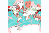
Number of globally threatened marine mammal species, by marine ecoregion. Using the online IUCN resource, the threatened species for each ecoregion were filtered for marine species only. Threatened species refer to those listed by IUCN Red List as Vulnerable, Endangered, or Critically Endangered (www.redlist.org). We downloaded the digital GIS data and summarized it by marine ecoregion to result in the number of threatened species per marine ecoregion. These data were derived by The Nature Conservancy, and were displayed in a map published in The Atlas of Global Conservation (Hoekstra et al., University of California Press, 2010). More information at http://nature.org/atlas. Data derived from: International Union...
This database is a compilation of marine mammal and seabird information collected along the Pacific coast of the United States and U.S. territories in the Pacific from surveys that were solicited among regional research communities and persons. Information from standardized surveys was gathered from 2015 to 2018 and includes programs and researchers who collected information regarding seabirds since 1960. These data support the following publication: Adams, J., Lafferty, K.D., Kelsey, E.C., and Johnston, C.A. 2019. Synopsis of Research Programs that can Provide Baseline and Monitoring Information for Offshore Energy Activities in the Pacific Region: Seabird and Marine Mammal Surveys in the Pacific Region. U.S....
This report presents updated information about subsistence uses of fish, wildlife, and plant resources in 5 communities of southcentral Alaska -- Iliamna, Newhalen, Nondalton, Pedro Bay, and Port Alsworth. The Division of Subsistence of the Alaska Department of Fish and Game conducted the study in collaboration with the National Park Service and Stephen R. Braund & Associates. The Pebble Project is a proposed open pit mine located 18 miles to the northwest of Iliamna and 18 miles southwest of Nondalton. The potential development of the mine requires updated baseline information about subsistence harvests and uses. Information was collected through systematic household surveys and mapping interviews. Scoping meetings...
This report presents updated information about subsistence uses of fish, wildlife, and plant resources in 5 communities of southcentral Alaska -- Iliamna, Newhalen, Nondalton, Pedro Bay, and Port Alsworth. The Division of Subsistence of the Alaska Department of Fish and Game conducted the study in collaboration with the National Park Service and Stephen R. Braund & Associates. The Pebble Project is a proposed open pit mine located 18 miles to the northwest of Iliamna and 18 miles southwest of Nondalton. The potential development of the mine requires updated baseline information about subsistence harvests and uses. Information was collected through systematic household surveys and mapping interviews. Scoping meetings...
We summarize available information on Pacific walrus haulouts from available reports, interviews with coastal residents and aviators, and personal observations of the authors. We provide this in the form of a georeferenced database that may be queried and displayed with standard geographic information system and database management software. The database contains 150 records of Pacific walrus haulouts, with a summary of basic characteristics on maximum haulout size, age-sex composition, season of use, and decade of most recent use. Citations to reports are provided as a bibliographic database.
Categories: Data;
Types: ArcGIS REST Map Service,
ArcGIS Service Definition,
Citation,
Downloadable,
Map Service,
OGC WFS Layer,
OGC WMS Layer,
Shapefile;
Tags: Alaska,
Arctic,
Arctic Ocean,
Beaufort Sea,
Bering Sea,
These are geospatial data that characterize the distribution of polar bear denning habitat on the National Petroleum Reserve–Alaska (NPR-A), the 1002 Area of the Arctic National Wildlife Refuge and the coastal plain of northern Alaska between the Colville River and the Alaska/Canada border.
This dataset is one table with results of tests to determine exposure of Chukchi Sea polar bears to a suite of pathogens. Results are serological tests for antibodies and tests of fecal samples for presence of parasites. Serologic assays were conducted for Toxoplasma gondii, Neospora caninum, Francisella tularensis, Coxiella burnetii, Leptospira spp., Brucella canis, Brucella abortus/suis, and canine distemper virus. Parasitology analyses were conducted for presence of Giardia cysts and Cryptospiridium oocysts in fecal samples. Polar bears were sampled on sea ice in the Chukchi Sea between mid-March and early May 1987-1994 and 2008-2017. The dataset includes relevant information about the bears that were captured...
|

|
