Filters: Tags: McGrath (X)
24 results (28ms)|
Filters
Date Range
Types Contacts
Tag Types Tag Schemes |
This data set contains imagery from the National Agriculture Imagery Program (NAIP). The NAIP program is administered by USDA FSA and has been established to support two main FSA strategic goals centered on agricultural production. These are, increase stewardship of America's natural resources while enhancing the environment, and to ensure commodities are procured and distributed effectively and efficiently to increase food security. The NAIP program supports these goals by acquiring and providing ortho imagery that has been collected during the agricultural growing season in the U.S. The NAIP ortho imagery is tailored to meet FSA requirements and is a fundamental tool used to support FSA farm and conservation programs....
This polygon feature class describes areas used for subsistence harvesting of brown bear in 2011 by surveyed households in McGrath, Alaska. This is a partial representation of areas used for resource harvesting in 2011.
This polygon feature class describes areas used for subsistence harvesting of black bear in 2011 by surveyed households in McGrath, Alaska. This is a partial representation of areas used for resource harvesting in 2011.
This polygon feature class describes areas used for subsistence harvesting of berries and plants in 2011 by surveyed households in McGrath, Alaska. This is a partial representation of areas used for resource harvesting in 2011.
This map is a compilation of previously unpublished and published data, as well as from updated field mapping. This publication offers a 1:125,000-scale map sheet accompanied by a booklet containing a summary of the geology, a colored terrane map, map unit descriptions, a summary table listing selected mineral deposits and energy resources, references, and a correlation of map units. The text (in the report) describes the geology and resource potential of a highly mineralized region centered in the Farewell silver-lead-zinc district southeast of McGrath. Potentially important coal resources flanking the Alaska Range are also described in the map area.
This points feature class describes areas used for subsistence harvesting of salmon in 2011 by surveyed households in McGrath, Alaska. This is a partial representation of areas used for resource harvesting in 2011.
This polygon feature class describes areas used for subsistence harvesting of ptarmigan and grouse in 2011 by surveyed households in McGrath, Alaska. This is a partial representation of areas used for resource harvesting in 2011.

USGS Historical Quadrangle in GeoPDF.
This data set contains imagery from the National Agriculture Imagery Program (NAIP). The NAIP program is administered by USDA FSA and has been established to support two main FSA strategic goals centered on agricultural production. These are, increase stewardship of America's natural resources while enhancing the environment, and to ensure commodities are procured and distributed effectively and efficiently to increase food security. The NAIP program supports these goals by acquiring and providing ortho imagery that has been collected during the agricultural growing season in the U.S. The NAIP ortho imagery is tailored to meet FSA requirements and is a fundamental tool used to support FSA farm and conservation programs....
This points feature class describes areas used for subsistence harvesting of northern pike in 2011 by surveyed households in McGrath, Alaska. This is a partial representation of areas used for resource harvesting in 2011.
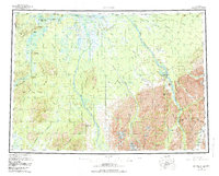
USGS Historical Quadrangle in GeoPDF.
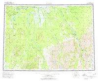
USGS Historical Quadrangle in GeoPDF.
This data set contains imagery from the National Agriculture Imagery Program (NAIP). The NAIP program is administered by USDA FSA and has been established to support two main FSA strategic goals centered on agricultural production. These are, increase stewardship of America's natural resources while enhancing the environment, and to ensure commodities are procured and distributed effectively and efficiently to increase food security. The NAIP program supports these goals by acquiring and providing ortho imagery that has been collected during the agricultural growing season in the U.S. The NAIP ortho imagery is tailored to meet FSA requirements and is a fundamental tool used to support FSA farm and conservation programs....
This polygon feature class describes areas used for subsistence harvesting of ducks and geese in 2011 by surveyed households in McGrath, Alaska. This is a partial representation of areas used for resource harvesting in 2011.
This polygon feature class describes areas used for subsistence harvesting of caribou in 2011 by surveyed households in McGrath, Alaska. This is a partial representation of areas used for resource harvesting in 2011.
This feature class describes areas used for subsistence harvesting of beaver in 2011 by surveyed households in McGrath, Alaska. This is a partial representation of areas used for resource harvesting in 2011.
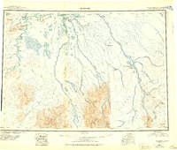
USGS Historical Quadrangle in GeoPDF.
This data set contains imagery from the National Agriculture Imagery Program (NAIP). The NAIP program is administered by USDA FSA and has been established to support two main FSA strategic goals centered on agricultural production. These are, increase stewardship of America's natural resources while enhancing the environment, and to ensure commodities are procured and distributed effectively and efficiently to increase food security. The NAIP program supports these goals by acquiring and providing ortho imagery that has been collected during the agricultural growing season in the U.S. The NAIP ortho imagery is tailored to meet FSA requirements and is a fundamental tool used to support FSA farm and conservation programs....
This points feature class describes areas used for subsistence harvesting of sheefish in 2011 by surveyed households in McGrath, Alaska. This is a partial representation of areas used for resource harvesting in 2011.
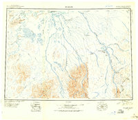
USGS Historical Quadrangle in GeoPDF.
|

|
