Filters
Date Types (for Date Range)
Contacts
Tag Types
Tag Schemes
|

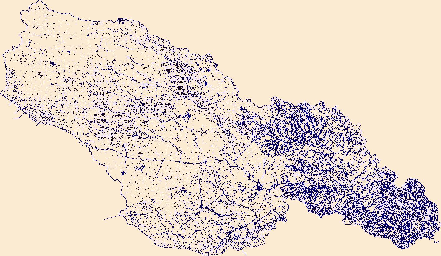
The High Resolution National Hydrography Dataset Plus (NHDPlus HR) is an integrated set of geospatial data layers, including the best available National Hydrography Dataset (NHD), the 10-meter 3D Elevation Program Digital Elevation Model (3DEP DEM), and the National Watershed Boundary Dataset (WBD). The NHDPlus HR combines the NHD, 3DEP DEMs, and WBD to create a stream network with linear referencing, feature naming, "value added attributes" (VAAs), elevation-derived catchments, and other features for hydrologic data analysis. The stream network with linear referencing is a system of data relationships applied to hydrographic systems so that one stream reach "flows" into another and "events" can be tied to and traced...
Tags: Abbeville County,
Aiken County,
Alexander County,
Allendale County,
Anderson County, All tags...
Avery County,
Bamberg County,
Barnwell County,
Beaufort County,
Berkeley County,
Buncombe County,
Burke County,
Caldwell County,
Calhoun County,
Catawba County,
Charleston County,
Cherokee County,
Chester County,
Clarendon County,
Cleveland County,
Colleton County,
Dorchester County,
Downloadable Data,
Edgefield County,
Fairfield County,
FileGDB,
FileGDB 10.1,
Gaston County,
Georgetown County,
Greenville County,
Greenwood County,
HU-4 Subregion,
HU-4 Subregion,
HU4_0305,
Hampton County,
Henderson County,
Hydrography,
Iredell County,
Jasper County,
Kershaw County,
Lancaster County,
Laurens County,
Lee County,
Lexington County,
Lincoln County,
McDowell County,
Mecklenburg County,
Mitchell County,
NC,
NHDPlus HR Rasters,
NHDPlus High Resolution (NHDPlus HR),
National Hydrography Dataset (NHD),
National Hydrography Dataset Plus High Resolution (NHDPlus HR),
National Hydrography Dataset Plus High Resolution (NHDPlus HR) Current,
Newberry County,
North Carolina,
Orangeburg County,
Pickens County,
Polk County,
Richland County,
Rutherford County,
SC,
Saluda County,
South Carolina,
Spartanburg County,
Sumter County,
Transylvania County,
US,
Union County,
Union County,
United States,
Watauga County,
Wilkes County,
Williamsburg County,
Yancey County,
York County,
base maps,
cartography,
catchments,
channels,
digital elevation models,
drainage basins,
earth sciences,
elevation,
environment,
geographic information systems,
geoscientific,
geospatial analysis,
hydrographic datasets,
hydrographic features,
hydrology,
imagery,
inland waters,
lakes,
land surface characteristics,
reservoirs,
river reaches,
rivers,
streamflow,
streamflow data,
streams,
topography,
water bodies,
water quality,
water resources,
watersheds, Fewer tags
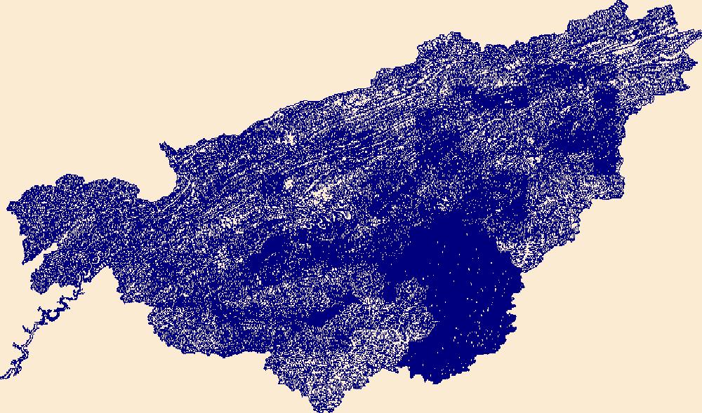
The High Resolution National Hydrography Dataset Plus (NHDPlus HR) is an integrated set of geospatial data layers, including the best available National Hydrography Dataset (NHD), the 10-meter 3D Elevation Program Digital Elevation Model (3DEP DEM), and the National Watershed Boundary Dataset (WBD). The NHDPlus HR combines the NHD, 3DEP DEMs, and WBD to create a stream network with linear referencing, feature naming, "value added attributes" (VAAs), elevation-derived catchments, and other features for hydrologic data analysis. The stream network with linear referencing is a system of data relationships applied to hydrographic systems so that one stream reach "flows" into another and "events" can be tied to and traced...
Tags: Andrews County,
Borden County,
Chaves County,
Cochran County,
Coke County, All tags...
Dawson County,
Downloadable Data,
Ector County,
FileGDB,
FileGDB 10.1,
Gaines County,
Garza County,
Glasscock County,
HU-4 Subregion,
HU-4 Subregion,
HU4_1208,
Hockley County,
Howard County,
Hydrography,
Lea County,
Lynn County,
Martin County,
Midland County,
Mitchell County,
NHDPlus HR Rasters,
NHDPlus High Resolution (NHDPlus HR),
NM,
National Hydrography Dataset (NHD),
National Hydrography Dataset Plus High Resolution (NHDPlus HR),
National Hydrography Dataset Plus High Resolution (NHDPlus HR) Current,
New Mexico,
Nolan County,
Roosevelt County,
Runnels County,
Scurry County,
Sterling County,
TX,
Terry County,
Texas,
US,
United States,
Upton County,
Winkler County,
Yoakum County,
base maps,
cartography,
catchments,
channels,
digital elevation models,
drainage basins,
earth sciences,
elevation,
environment,
geographic information systems,
geoscientific,
geospatial analysis,
hydrographic datasets,
hydrographic features,
hydrology,
imagery,
inland waters,
lakes,
land surface characteristics,
reservoirs,
river reaches,
rivers,
streamflow,
streamflow data,
streams,
topography,
water bodies,
water quality,
water resources,
watersheds, Fewer tags
The High Resolution National Hydrography Dataset Plus (NHDPlus HR) is an integrated set of geospatial data layers, including the best available National Hydrography Dataset (NHD), the 10-meter 3D Elevation Program Digital Elevation Model (3DEP DEM), and the National Watershed Boundary Dataset (WBD). The NHDPlus HR combines the NHD, 3DEP DEMs, and WBD to create a stream network with linear referencing, feature naming, "value added attributes" (VAAs), elevation-derived catchments, and other features for hydrologic data analysis. The stream network with linear referencing is a system of data relationships applied to hydrographic systems so that one stream reach "flows" into another and "events" can be tied to and traced...
Tags: Archer County,
Baylor County,
Bosque County,
Callahan County,
Coryell County, All tags...
Dickens County,
Downloadable Data,
Eastland County,
Erath County,
Falls County,
FileGDB,
FileGDB 10.1,
Fisher County,
HU-4 Subregion,
HU-4 Subregion,
HU4_1206,
Hamilton County,
Haskell County,
Hill County,
Hood County,
Hydrography,
Jack County,
Johnson County,
Jones County,
King County,
Knox County,
Limestone County,
McLennan County,
Mitchell County,
NHDPlus HR Rasters,
NHDPlus High Resolution (NHDPlus HR),
National Hydrography Dataset (NHD),
National Hydrography Dataset Plus High Resolution (NHDPlus HR),
National Hydrography Dataset Plus High Resolution (NHDPlus HR) Current,
Nolan County,
Palo Pinto County,
Parker County,
Scurry County,
Shackelford County,
Somervell County,
Stephens County,
Stonewall County,
TX,
Taylor County,
Texas,
Throckmorton County,
US,
United States,
Young County,
base maps,
cartography,
catchments,
channels,
digital elevation models,
drainage basins,
earth sciences,
elevation,
environment,
geographic information systems,
geoscientific,
geospatial analysis,
hydrographic datasets,
hydrographic features,
hydrology,
imagery,
inland waters,
lakes,
land surface characteristics,
reservoirs,
river reaches,
rivers,
streamflow,
streamflow data,
streams,
topography,
water bodies,
water quality,
water resources,
watersheds, Fewer tags
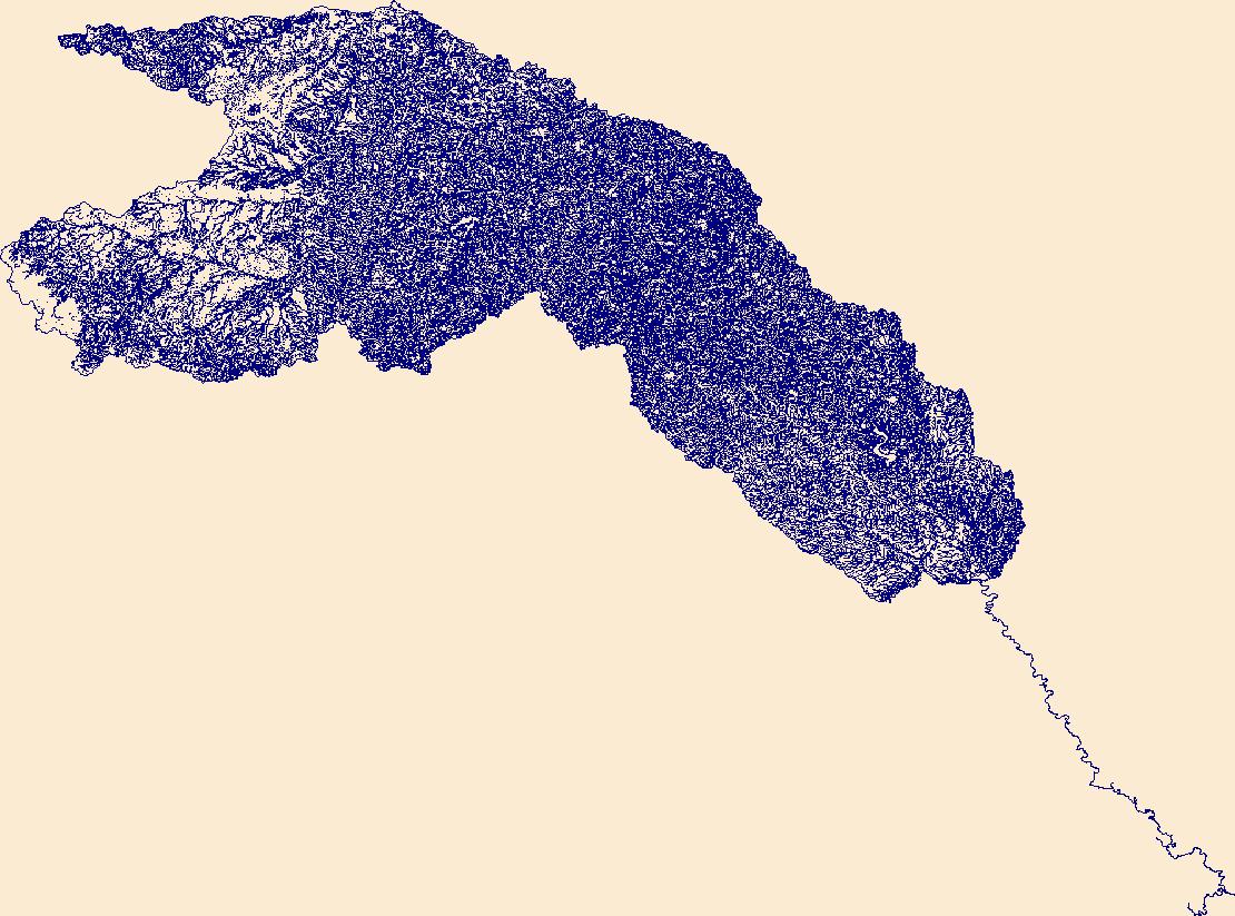
The High Resolution National Hydrography Dataset Plus (NHDPlus HR) is an integrated set of geospatial data layers, including the National Hydrography Dataset (NHD), National Watershed Boundary Dataset (WBD), and 3D Elevation Program Digital Elevation Model (3DEP DEM). The NHDPlus HR combines the NHD, 3DEP DEMs, and WBD to a data suite that includes the NHD stream network with linear referencing functionality, the WBD hydrologic units, elevation-derived catchment areas for each stream segment, "value added attributes" (VAAs), and other features that enhance hydrologic data analysis and routing.
Tags: 4-digit hydrologic unit,
Anderson County,
Ashe County,
Avery County,
Bell County, All tags...
Bland County,
Bledsoe County,
Blount County,
Bristol County,
Buchanan County,
Buncombe County,
Caldwell County,
Campbell County,
Carter County,
Cherokee County,
Claiborne County,
Clay County,
Cocke County,
Cumberland County,
Dickenson County,
Downloadable Data,
Fentress County,
FileGDB,
GA,
Georgia,
Graham County,
Grainger County,
Grayson County,
Greene County,
Greenville County,
HU-4 Subregion,
HU4,
HU4_0601,
Hamblen County,
Hancock County,
Harlan County,
Hawkins County,
Haywood County,
Henderson County,
Hydrography,
Jackson County,
Jefferson County,
Johnson County,
KY,
Kentucky,
Knox County,
Lee County,
Letcher County,
Loudon County,
Macon County,
Madison County,
McDowell County,
McMinn County,
Meigs County,
Mitchell County,
Monroe County,
Morgan County,
NC,
NHDPlus HR Rasters,
NHDPlus High Resolution (NHDPlus HR),
National Hydrography Dataset (NHD),
National Hydrography Dataset Plus High Resolution (NHDPlus HR),
National Hydrography Dataset Plus High Resolution (NHDPlus HR) Current,
North Carolina,
Norton County,
Pickens County,
Putnam County,
Rabun County,
Rhea County,
Roane County,
Russell County,
SC,
Scott County,
Sevier County,
Smyth County,
South Carolina,
Sullivan County,
Swain County,
TN,
Tazewell County,
Tennessee,
Transylvania County,
US,
Unicoi County,
Union County,
United States,
VA,
Virginia,
WV,
Washington County,
Watauga County,
West Virginia,
Wise County,
Wythe County,
Yancey County,
base maps,
cartography,
catchments,
channels,
digital elevation models,
drainage basins,
earthsciences,
environment,
geographic information systems,
geoscientificInformation,
geospatial analysis,
hydrographic datasets,
hydrographic features,
hydrology,
inlandWaters,
lakes,
land surface characteristics,
reservoirs,
river reaches,
rivers,
streamflow,
streamflow data,
streams,
surface water quality,
topography,
water resources,
waterbodies,
watersheds, Fewer tags
|
|

