Filters
Date Types (for Date Range)
Extensions
Types
Contacts
Categories
Tag Types
Tag Schemes
|
Geospatial data is comprised of government boundaries.
Tags: Belknap,
Boundaries,
Carroll,
Cheshire,
Coos, All tags...
County or Equivalent,
Downloadable Data,
GeoPackage,
Grafton,
Hillsborough,
Incorporated Place,
Jurisdictional,
Merrimack,
Minor Civil Division,
NH,
National Boundary Dataset (NBD),
National Boundary Dataset (NBD),
Native American Area,
New Hampshire,
Open Geospatial Consortium GeoPackage 1.2,
PLSS First Division,
PLSS Special Survey,
PLSS Township,
Public Land Survey System,
Reserve,
Rockingham,
State,
State,
State or Territory,
Strafford,
Sullivan,
U.S. National Grid,
US,
Unincorporated Place,
United States,
boundaries,
boundary,
cadastral surveys,
geographic names,
land ownership,
land use maps,
legal land descriptions,
political and administrative boundaries,
zoning maps, Fewer tags
Layers of geospatial data include roads, airports, trails, and railroads.
Tags: Airport Complex,
Airport Point,
Airport Runway,
Airports,
Airstrips, All tags...
Belknap,
Carroll,
Cheshire,
Coos,
Downloadable Data,
GeoPackage,
Geographic names,
Grafton,
Hillsborough,
Merrimack,
NH,
National Transportation Dataset (NTD),
National Transportation Dataset (NTD),
New Hampshire,
Open Geospatial Consortium GeoPackage 1.2,
Railways,
Roads,
Rockingham,
State,
State,
Strafford,
Sullivan,
Trail,
Trails,
Transportation,
Transportation,
US,
United States,
Waterway,
transportation, Fewer tags

The Geographic Names Information System (GNIS) is the Federal standard for geographic nomenclature. The U.S. Geological Survey developed the GNIS for the U.S. Board on Geographic Names, a Federal inter-agency body chartered by public law to maintain uniform feature name usage throughout the Government and to promulgate standard names to the public. The GNIS is the official repository of domestic geographic names data; the official vehicle for geographic names use by all departments of the Federal Government; and the source for applying geographic names to Federal electronic and printed products of all types.
Tags: AK,
AL,
AR,
AS,
AZ, All tags...
Alabama,
Alaska,
American Samoa,
Antarctica,
Antarctica,
Arizona,
Arkansas,
BGN,
Board on Geographic Names,
Borough,
CA,
CO,
CT,
California,
Census Area,
Colorado,
Commonwealth,
Connecticut,
County,
DC,
DE,
Delaware,
District,
District of Columbia,
Downloadable Data,
Esri File GeoDatabase 10,
FL,
Feature class,
Feature coordinates,
Feature county,
Feature description,
Feature designation,
Feature history,
Feature indentification,
Feature name,
Feature state,
FileGDB,
Florida,
GA,
GNIS,
GU,
Geographic Names,
Geographic Names Full Model,
Geographic Names Information System,
Geographic feature,
Geographic name,
Geographical feature,
Geographical name,
Georgia,
Guam,
HI,
Hawaii,
IA,
ID,
IL,
IN,
Idaho,
Illinois,
Indiana,
Iowa,
KS,
KY,
Kansas,
Kentucky,
LA,
Louisiana,
MA,
MD,
ME,
MI,
MN,
MO,
MP,
MS,
MT,
Maine,
Maryland,
Massachusetts,
Michigan,
Minnesota,
Mississippi,
Missouri,
Montana,
Municipio,
NC,
ND,
NE,
NH,
NJ,
NM,
NV,
NY,
National,
National,
National Geographic Names Information System (GNIS),
National Geographic Names Information System (GNIS),
Nebraska,
Nevada,
New Hampshire,
New Jersey,
New Mexico,
New York,
North Carolina,
North Dakota,
Northern Mariana Islands,
OH,
OK,
OR,
Official feature name,
Ohio,
Oklahoma,
Oregon,
Outlying Area,
PA,
PR,
Parish,
Pennsylvania,
Place name,
Populated Place,
Puerto Rico,
RI,
Rhode Island,
SC,
SD,
South Carolina,
South Dakota,
TN,
TX,
Tennessee,
Territories,
Territory,
Texas,
Topographic Map,
U.S. Board on Geographic Names,
U.S. Geological Survey,
US,
USA,
USBGN,
USGS,
UT,
United States,
United States,
United States,
Utah,
VA,
VI,
VT,
Variant name,
Vermont,
Virgin Islands,
Virginia,
WA,
WI,
WV,
WY,
Washington,
West Virginia,
Wisconsin,
Wyoming,
antarctic,
database,
economy,
environment,
feature,
gazetteer,
geographic,
geographic names,
geographical,
geography,
geospatial,
imageryBaseMapsEarthCover,
inlandWaters,
location,
map,
name,
place,
placename,
society,
structure,
topographic map,
toponymy, Fewer tags
Layers of geospatial data include contours, boundaries, land cover, hydrography, roads, transportation, geographic names, structures, and other selected map features.
Types: Citation;
Tags: 7.5 x 7.5 minute,
7_5_Min,
Belknap,
Carroll,
Combined Vector, All tags...
Combined Vector,
Combined Vector,
Downloadable Data,
Esri Shapefile nan,
Grafton,
NH,
New Hampshire,
Public Land Survey System,
Shapefile,
Topo Map Vector Data,
US,
United States,
boundary,
contours,
geographic names,
hydrography,
structures,
transportation,
woodland, Fewer tags

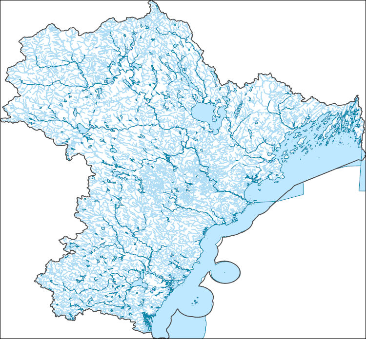
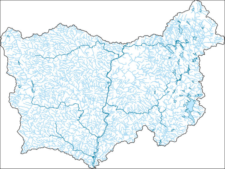
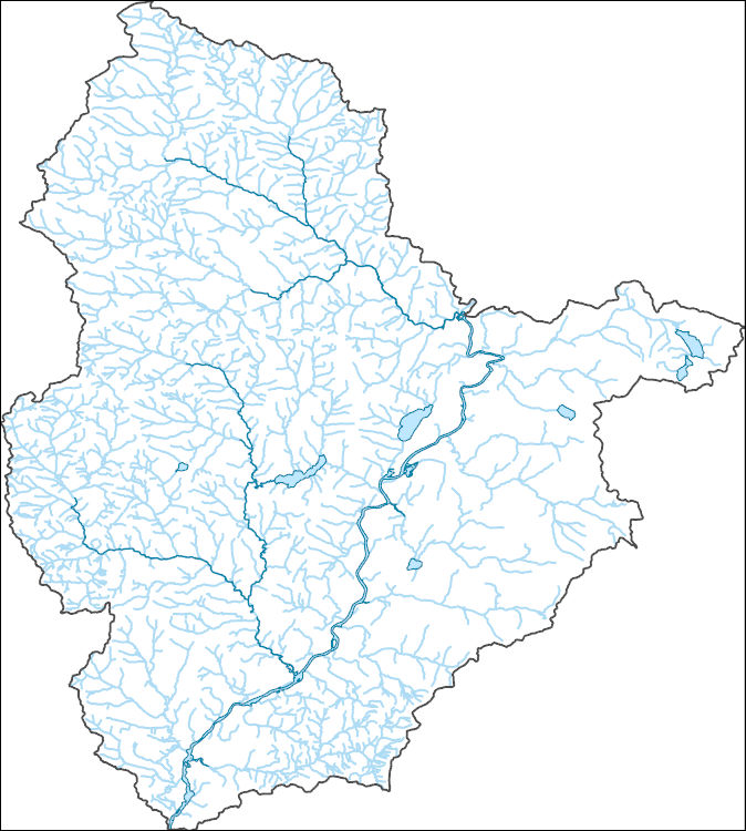
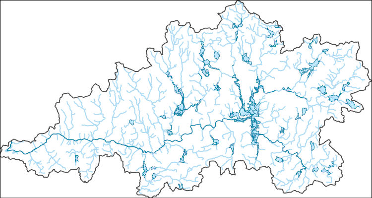
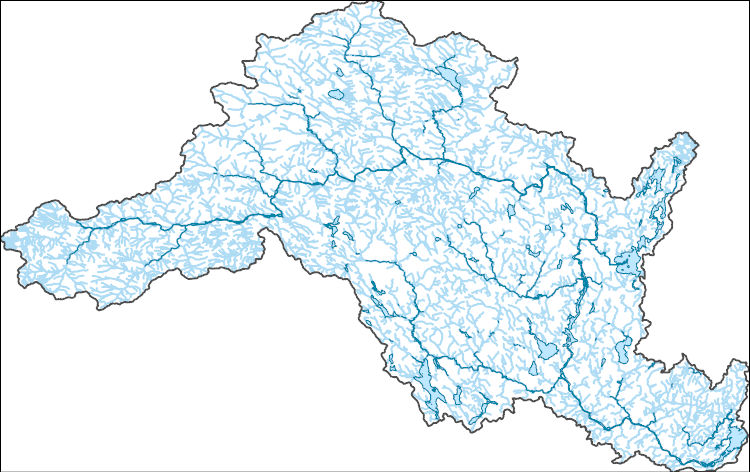
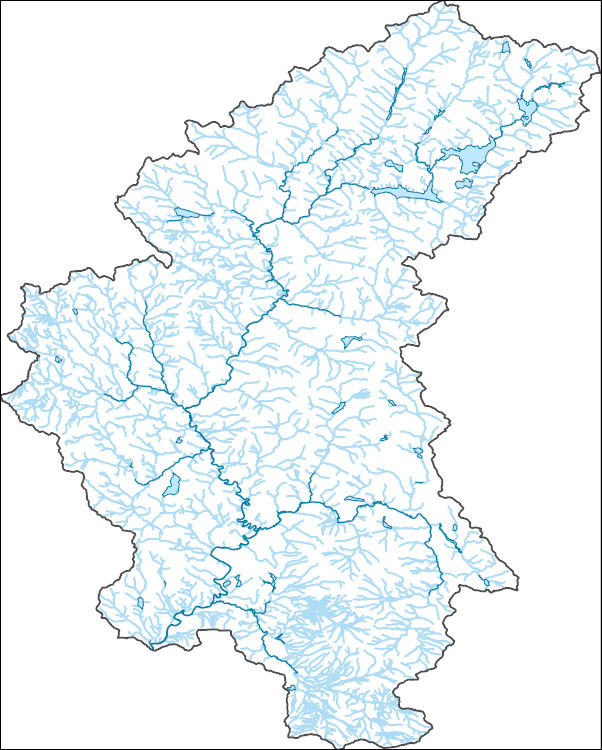
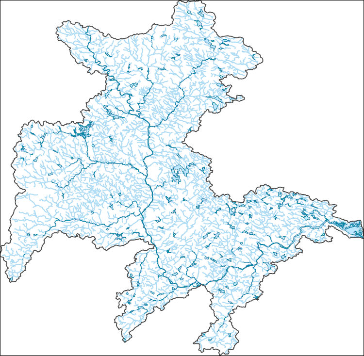
The High Resolution National Hydrography Dataset Plus (NHDPlus HR) is an integrated set of geospatial data layers, including the National Hydrography Dataset (NHD), National Watershed Boundary Dataset (WBD), and 3D Elevation Program Digital Elevation Model (3DEP DEM). The NHDPlus HR combines the NHD, 3DEP DEMs, and WBD to a data suite that includes the NHD stream network with linear referencing functionality, the WBD hydrologic units, elevation-derived catchment areas for each stream segment, "value added attributes" (VAAs), and other features that enhance hydrologic data analysis and routing.
Tags: 4-digit hydrologic unit,
Addison County,
Bennington County,
Berkshire County,
CT, All tags...
Caledonia County,
Carroll County,
Cheshire County,
Connecticut,
Coos County,
Downloadable Data,
Essex County,
FileGDB,
Franklin County,
Grafton County,
HU-4 Subregion,
HU4,
HU4_0108,
Hampden County,
Hampshire County,
Hartford County,
Hillsborough County,
Hydrography,
Litchfield County,
MA,
ME,
Maine,
Massachusetts,
Merrimack County,
Middlesex County,
NH,
NHDPlus HR Rasters,
NHDPlus High Resolution (NHDPlus HR),
National Hydrography Dataset (NHD),
National Hydrography Dataset Plus High Resolution (NHDPlus HR),
National Hydrography Dataset Plus High Resolution (NHDPlus HR) Current,
New Hampshire,
New Haven County,
New London County,
Orange County,
Orleans County,
Oxford County,
Rutland County,
Sullivan County,
Tolland County,
US,
United States,
VT,
Vermont,
Washington County,
Windham County,
Windsor County,
Worcester County,
base maps,
cartography,
catchments,
channels,
digital elevation models,
drainage basins,
earthsciences,
environment,
geographic information systems,
geoscientificInformation,
geospatial analysis,
hydrographic datasets,
hydrographic features,
hydrology,
inlandWaters,
lakes,
land surface characteristics,
reservoirs,
river reaches,
rivers,
streamflow,
streamflow data,
streams,
surface water quality,
topography,
water resources,
waterbodies,
watersheds, Fewer tags

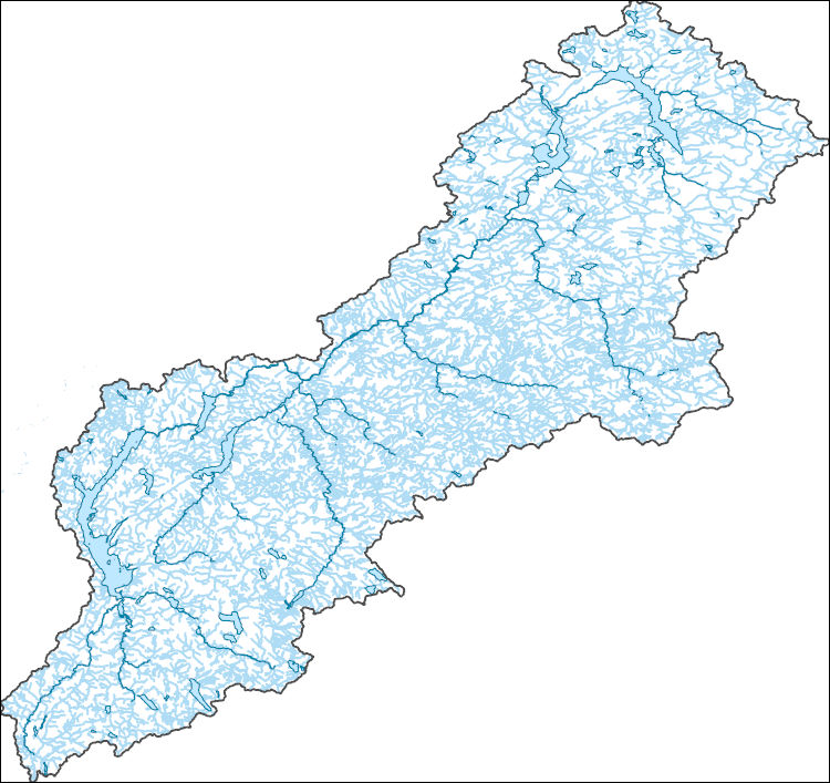
The High Resolution National Hydrography Dataset Plus (NHDPlus HR) is an integrated set of geospatial data layers, including the National Hydrography Dataset (NHD), National Watershed Boundary Dataset (WBD), and 3D Elevation Program Digital Elevation Model (3DEP DEM). The NHDPlus HR combines the NHD, 3DEP DEMs, and WBD to a data suite that includes the NHD stream network with linear referencing functionality, the WBD hydrologic units, elevation-derived catchment areas for each stream segment, "value added attributes" (VAAs), and other features that enhance hydrologic data analysis and routing.
Tags: Belknap,
Carroll,
Cheshire,
Downloadable Data,
Esri File GeoDatabase 10, All tags...
Essex,
FileGDB,
Grafton,
HU-4,
HU-4 Subregion,
HU4_0107,
Hillsborough,
Hydrography,
MA,
Massachusetts,
Merrimack,
Middlesex,
NH,
NHDPlus HR Rasters,
NHDPlus High Resolution (NHDPlus HR),
National Hydrography Dataset (NHD),
National Hydrography Dataset Plus High Resolution (NHDPlus HR),
National Hydrography Dataset Plus High Resolution (NHDPlus HR) Current,
New Hampshire,
Rockingham,
Strafford,
Sullivan,
US,
United States,
Worcester,
base maps,
cartography,
catchments,
channels,
digital elevation models,
drainage basins,
earthsciences,
environment,
geographic information systems,
geoscientificInformation,
geospatial analysis,
hydrographic datasets,
hydrographic features,
hydrology,
inlandWaters,
lakes,
land surface characteristics,
reservoirs,
river reaches,
rivers,
streamflow,
streamflow data,
streams,
surface water quality,
topography,
water resources,
waterbodies,
watersheds, Fewer tags
The Watershed Boundary Dataset (WBD) is a comprehensive aggregated collection of hydrologic unit data consistent with the national criteria for delineation and resolution. It defines the areal extent of surface water drainage to a point except in coastal or lake front areas where there could be multiple outlets as stated by the "Federal Standards and Procedures for the National Watershed Boundary Dataset (WBD)" "Standard" (https://pubs.usgs.gov/tm/11/a3/). Watershed boundaries are determined solely upon science-based hydrologic principles, not favoring any administrative boundaries or special projects, nor particular program or agency. This dataset represents the hydrologic unit boundaries to the 12-digit (6th level)...
Tags: 10-digit,
12-digit,
14-digit,
16-digit,
2-digit, All tags...
4-digit,
6-digit,
8-digit,
Addison,
Androscoggin,
Aroostook,
Barnstable,
Basin,
Belknap,
Bennington,
Berkshire,
Bristol,
CT,
Caledonia,
Capitol,
Carroll,
Cheshire,
Columbia,
Connecticut,
Coos,
Cumberland,
Downloadable Data,
Dukes,
Dutchess,
Essex,
Franklin,
GeoPackage,
Grafton,
Greater Bridgeport,
HU-2,
HU-2 Region,
HU2_01,
HUC,
Hampden,
Hampshire,
Hancock,
Hillsborough,
Hydrography,
Hydrologic Unit Code,
Hydrologic Units,
Kennebec,
Kent,
Knox,
Lincoln,
Lower Connecticut River Valley,
MA,
ME,
Maine,
Massachusetts,
Merrimack,
Middlesex,
NH,
NY,
Nantucket,
National Watershed Boundary Dataset (WBD),
National Watershed Boundary Dataset (WBD),
Naugatuck Valley,
New Hampshire,
New York,
Newport,
Norfolk,
Northeastern Connecticut,
Northwest Hills,
Open Geospatial Consortium GeoPackage 1.2,
Orange,
Orleans,
Oxford,
Penobscot,
Piscataquis,
Plymouth,
Providence,
Putnam,
RI,
Region,
Rhode Island,
Rockingham,
Rutland,
Sagadahoc,
Somerset,
South Central Connecticut,
Southeastern Connecticut,
Strafford,
Sub-basin,
Sub-region,
Subwatershed,
Suffolk,
Sullivan,
US,
United States,
VT,
Vermont,
WBD,
Waldo,
Washington,
Watershed,
Watershed Boundary Dataset,
Westchester,
Western Connecticut,
Windham,
Windsor,
Worcester,
York,
inlandWaters, Fewer tags
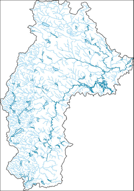
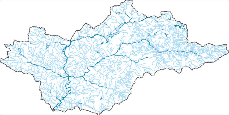
The National Hydrography Dataset (NHD) is a feature-based database that interconnects and uniquely identifies the stream segments or reaches that make up the nation's surface water drainage system. NHD data was originally developed at 1:100,000-scale and exists at that scale for the whole country. This high-resolution NHD, generally developed at 1:24,000/1:12,000 scale, adds detail to the original 1:100,000-scale NHD. (Data for Alaska, Puerto Rico and the Virgin Islands was developed at high-resolution, not 1:100,000 scale.) Local resolution NHD is being developed where partners and data exist. The NHD contains reach codes for networked features, flow direction, names, and centerline representations for areal water...
Tags: Administrative watershed units,
Administrative watershed units,
Androscoggin,
Area of Complex Channels,
Area to be submerged, All tags...
Basin,
Basin,
Bay/Inlet,
Belknap,
Boundaries,
Boundary,
Bridge,
Canal/Ditch,
Carroll,
Coastline,
Connector,
Coos,
Cumberland,
Dam/Weir,
Downloadable Data,
Drainage areas for surface water,
Drainageway,
Esri File GeoDatabase 10,
Essex,
Estuary,
FileGDB,
Flow direction network,
Flume,
ForeShore,
Gaging Station,
Gate,
Grafton,
HU-4,
HU-4 Subregion,
HU10,
HU12,
HU14,
HU16,
HU2,
HU4,
HU4_0106,
HU6,
HU8,
HUC,
Hazard Zone,
Hydrographic,
Hydrography,
Hydrography,
Hydrography,
Hydrologic Unit Code,
Hydrologic Units,
Ice mass,
Inundation Area,
Levee,
Line,
Lock Chamber,
MA,
ME,
Maine,
Marsh,
Massachusetts,
Merrimack,
NH,
National Hydrography Dataset (NHD),
National Hydrography Dataset (NHD) Best Resolution,
National Hydrography Dataset (NHD) Best Resolution,
New Hampshire,
Nonearthen Shore,
Orthoimage,
Oxford,
Playa,
Point,
PointEvent,
Pond,
Rapids,
Rapids,
Reach,
Reach code,
Reef,
Region,
Reservoir,
Rock,
Rockingham,
Sagadahoc,
Sea/Ocean,
Sink/Rise,
Sounding Datum Line,
Special Use Zone,
Special Use Zone Limit,
Spillway,
Strafford,
Stream,
Stream/River,
Sub-basin,
Sub-region,
Subbasin,
Submerged Stream,
Subregion,
Subwatershed,
Surface water systems,
Swamp,
Topographic,
Tunnel,
US,
Underground Conduit,
United States,
WBD,
WBD,
Wall,
Wash,
Water Intake Outflow,
Waterfall,
Watershed,
Watershed Boundaries,
Watershed Boundary Dataset,
Watershed Boundary Dataset,
Well,
York,
artificial path,
boundaries,
dams,
drainage systems and characteristics,
inlandWaters,
lakes,
ngda,
rivers, Fewer tags
The National Hydrography Dataset (NHD) is a feature-based database that interconnects and uniquely identifies the stream segments or reaches that make up the nation's surface water drainage system. NHD data was originally developed at 1:100,000-scale and exists at that scale for the whole country. This high-resolution NHD, generally developed at 1:24,000/1:12,000 scale, adds detail to the original 1:100,000-scale NHD. (Data for Alaska, Puerto Rico and the Virgin Islands was developed at high-resolution, not 1:100,000 scale.) Local resolution NHD is being developed where partners and data exist. The NHD contains reach codes for networked features, flow direction, names, and centerline representations for areal water...
Tags: Administrative watershed units,
Administrative watershed units,
Area of Complex Channels,
Area to be submerged,
Basin, All tags...
Basin,
Bay/Inlet,
Boundaries,
Boundary,
Bridge,
Caledonia,
Canal/Ditch,
Coastline,
Connector,
Coos,
Dam/Weir,
Downloadable Data,
Drainage areas for surface water,
Drainageway,
Esri File GeoDatabase 10,
Essex,
Estuary,
FileGDB,
Flow direction network,
Flume,
ForeShore,
Gaging Station,
Gate,
HU-8,
HU-8 Subbasin,
HU10,
HU12,
HU14,
HU16,
HU2,
HU4,
HU6,
HU8,
HU8_04300202,
HUC,
Hazard Zone,
Hydrographic,
Hydrography,
Hydrography,
Hydrography,
Hydrologic Unit Code,
Hydrologic Units,
Ice mass,
Inundation Area,
Lamoille,
Levee,
Line,
Lock Chamber,
ME,
Maine,
Marsh,
NH,
National Hydrography Dataset (NHD),
National Hydrography Dataset (NHD) Best Resolution,
National Hydrography Dataset (NHD) Best Resolution,
New Hampshire,
Nonearthen Shore,
Orleans,
Orthoimage,
Oxford,
Playa,
Point,
PointEvent,
Pond,
Rapids,
Rapids,
Reach,
Reach code,
Reef,
Region,
Reservoir,
Rock,
Sea/Ocean,
Sink/Rise,
Sounding Datum Line,
Special Use Zone,
Special Use Zone Limit,
Spillway,
Stream,
Stream/River,
Sub-basin,
Sub-region,
Subbasin,
Submerged Stream,
Subregion,
Subwatershed,
Surface water systems,
Swamp,
Topographic,
Tunnel,
US,
Underground Conduit,
United States,
VT,
Vermont,
WBD,
WBD,
Wall,
Wash,
Water Intake Outflow,
Waterfall,
Watershed,
Watershed Boundaries,
Watershed Boundary Dataset,
Watershed Boundary Dataset,
Well,
artificial path,
boundaries,
dams,
drainage systems and characteristics,
inlandWaters,
lakes,
ngda,
rivers, Fewer tags
The National Hydrography Dataset (NHD) is a feature-based database that interconnects and uniquely identifies the stream segments or reaches that make up the nation's surface water drainage system. NHD data was originally developed at 1:100,000-scale and exists at that scale for the whole country. This high-resolution NHD, generally developed at 1:24,000/1:12,000 scale, adds detail to the original 1:100,000-scale NHD. (Data for Alaska, Puerto Rico and the Virgin Islands was developed at high-resolution, not 1:100,000 scale.) Local resolution NHD is being developed where partners and data exist. The NHD contains reach codes for networked features, flow direction, names, and centerline representations for areal water...
Tags: Administrative watershed units,
Administrative watershed units,
Area of Complex Channels,
Area to be submerged,
Basin, All tags...
Basin,
Bay/Inlet,
Boundaries,
Boundary,
Bridge,
Canal/Ditch,
Cheshire,
Coastline,
Connector,
Dam/Weir,
Downloadable Data,
Drainage areas for surface water,
Drainageway,
Esri Shapefile nan,
Estuary,
Flow direction network,
Flume,
ForeShore,
Gaging Station,
Gate,
HU-8,
HU-8 Subbasin,
HU10,
HU12,
HU14,
HU16,
HU2,
HU4,
HU6,
HU8,
HU8_01070003,
HUC,
Hazard Zone,
Hillsborough,
Hydrographic,
Hydrography,
Hydrography,
Hydrography,
Hydrologic Unit Code,
Hydrologic Units,
Ice mass,
Inundation Area,
Levee,
Line,
Lock Chamber,
Marsh,
Merrimack,
NH,
National Hydrography Dataset (NHD),
National Hydrography Dataset (NHD) Best Resolution,
National Hydrography Dataset (NHD) Best Resolution,
New Hampshire,
Nonearthen Shore,
Orthoimage,
Playa,
Point,
PointEvent,
Pond,
Rapids,
Rapids,
Reach,
Reach code,
Reef,
Region,
Reservoir,
Rock,
Sea/Ocean,
Shapefile,
Sink/Rise,
Sounding Datum Line,
Special Use Zone,
Special Use Zone Limit,
Spillway,
Stream,
Stream/River,
Sub-basin,
Sub-region,
Subbasin,
Submerged Stream,
Subregion,
Subwatershed,
Sullivan,
Surface water systems,
Swamp,
Topographic,
Tunnel,
US,
Underground Conduit,
United States,
WBD,
WBD,
Wall,
Wash,
Water Intake Outflow,
Waterfall,
Watershed,
Watershed Boundaries,
Watershed Boundary Dataset,
Watershed Boundary Dataset,
Well,
artificial path,
boundaries,
dams,
drainage systems and characteristics,
inlandWaters,
lakes,
ngda,
rivers, Fewer tags
The National Hydrography Dataset (NHD) is a feature-based database that interconnects and uniquely identifies the stream segments or reaches that make up the nation's surface water drainage system. NHD data was originally developed at 1:100,000-scale and exists at that scale for the whole country. This high-resolution NHD, generally developed at 1:24,000/1:12,000 scale, adds detail to the original 1:100,000-scale NHD. (Data for Alaska, Puerto Rico and the Virgin Islands was developed at high-resolution, not 1:100,000 scale.) Local resolution NHD is being developed where partners and data exist. The NHD contains reach codes for networked features, flow direction, names, and centerline representations for areal water...
Tags: Administrative watershed units,
Administrative watershed units,
Area of Complex Channels,
Area to be submerged,
Basin, All tags...
Basin,
Bay/Inlet,
Boundaries,
Boundary,
Bridge,
Caledonia,
Canal/Ditch,
Carroll,
Coastline,
Connector,
Coos,
Dam/Weir,
Downloadable Data,
Drainage areas for surface water,
Drainageway,
Esri Shapefile nan,
Essex,
Estuary,
Flow direction network,
Flume,
ForeShore,
Gaging Station,
Gate,
Grafton,
HU-8,
HU-8 Subbasin,
HU10,
HU12,
HU14,
HU16,
HU2,
HU4,
HU6,
HU8,
HU8_01080103,
HUC,
Hazard Zone,
Hydrographic,
Hydrography,
Hydrography,
Hydrography,
Hydrologic Unit Code,
Hydrologic Units,
Ice mass,
Inundation Area,
Levee,
Line,
Lock Chamber,
Marsh,
NH,
National Hydrography Dataset (NHD),
National Hydrography Dataset (NHD) Best Resolution,
National Hydrography Dataset (NHD) Best Resolution,
New Hampshire,
Nonearthen Shore,
Orange,
Orthoimage,
Playa,
Point,
PointEvent,
Pond,
Rapids,
Rapids,
Reach,
Reach code,
Reef,
Region,
Reservoir,
Rock,
Sea/Ocean,
Shapefile,
Sink/Rise,
Sounding Datum Line,
Special Use Zone,
Special Use Zone Limit,
Spillway,
Stream,
Stream/River,
Sub-basin,
Sub-region,
Subbasin,
Submerged Stream,
Subregion,
Subwatershed,
Surface water systems,
Swamp,
Topographic,
Tunnel,
US,
Underground Conduit,
United States,
VT,
Vermont,
WBD,
WBD,
Wall,
Wash,
Washington,
Water Intake Outflow,
Waterfall,
Watershed,
Watershed Boundaries,
Watershed Boundary Dataset,
Watershed Boundary Dataset,
Well,
artificial path,
boundaries,
dams,
drainage systems and characteristics,
inlandWaters,
lakes,
ngda,
rivers, Fewer tags
The National Hydrography Dataset (NHD) is a feature-based database that interconnects and uniquely identifies the stream segments or reaches that make up the nation's surface water drainage system. NHD data was originally developed at 1:100,000-scale and exists at that scale for the whole country. This high-resolution NHD, generally developed at 1:24,000/1:12,000 scale, adds detail to the original 1:100,000-scale NHD. (Data for Alaska, Puerto Rico and the Virgin Islands was developed at high-resolution, not 1:100,000 scale.) Local resolution NHD is being developed where partners and data exist. The NHD contains reach codes for networked features, flow direction, names, and centerline representations for areal water...
Tags: Administrative watershed units,
Administrative watershed units,
Area of Complex Channels,
Area to be submerged,
Basin, All tags...
Basin,
Bay/Inlet,
Boundaries,
Boundary,
Bridge,
Canal/Ditch,
Cheshire,
Coastline,
Connector,
Dam/Weir,
Downloadable Data,
Drainage areas for surface water,
Drainageway,
Esri Shapefile nan,
Estuary,
Flow direction network,
Flume,
ForeShore,
Gaging Station,
Gate,
Grafton,
HU-8,
HU-8 Subbasin,
HU10,
HU12,
HU14,
HU16,
HU2,
HU4,
HU6,
HU8,
HU8_01080106,
HUC,
Hazard Zone,
Hydrographic,
Hydrography,
Hydrography,
Hydrography,
Hydrologic Unit Code,
Hydrologic Units,
Ice mass,
Inundation Area,
Levee,
Line,
Lock Chamber,
Marsh,
Merrimack,
NH,
National Hydrography Dataset (NHD),
National Hydrography Dataset (NHD) Best Resolution,
National Hydrography Dataset (NHD) Best Resolution,
New Hampshire,
Nonearthen Shore,
Orthoimage,
Playa,
Point,
PointEvent,
Pond,
Rapids,
Rapids,
Reach,
Reach code,
Reef,
Region,
Reservoir,
Rock,
Rutland,
Sea/Ocean,
Shapefile,
Sink/Rise,
Sounding Datum Line,
Special Use Zone,
Special Use Zone Limit,
Spillway,
Stream,
Stream/River,
Sub-basin,
Sub-region,
Subbasin,
Submerged Stream,
Subregion,
Subwatershed,
Sullivan,
Surface water systems,
Swamp,
Topographic,
Tunnel,
US,
Underground Conduit,
United States,
VT,
Vermont,
WBD,
WBD,
Wall,
Wash,
Water Intake Outflow,
Waterfall,
Watershed,
Watershed Boundaries,
Watershed Boundary Dataset,
Watershed Boundary Dataset,
Well,
Windham,
Windsor,
artificial path,
boundaries,
dams,
drainage systems and characteristics,
inlandWaters,
lakes,
ngda,
rivers, Fewer tags
The National Hydrography Dataset (NHD) is a feature-based database that interconnects and uniquely identifies the stream segments or reaches that make up the nation's surface water drainage system. NHD data was originally developed at 1:100,000-scale and exists at that scale for the whole country. This high-resolution NHD, generally developed at 1:24,000/1:12,000 scale, adds detail to the original 1:100,000-scale NHD. (Data for Alaska, Puerto Rico and the Virgin Islands was developed at high-resolution, not 1:100,000 scale.) Local resolution NHD is being developed where partners and data exist. The NHD contains reach codes for networked features, flow direction, names, and centerline representations for areal water...
Tags: Administrative watershed units,
Administrative watershed units,
Area of Complex Channels,
Area to be submerged,
Basin, All tags...
Basin,
Bay/Inlet,
Boundaries,
Boundary,
Bridge,
Caledonia,
Canal/Ditch,
Coastline,
Connector,
Dam/Weir,
Downloadable Data,
Drainage areas for surface water,
Drainageway,
Esri Shapefile nan,
Estuary,
Flow direction network,
Flume,
ForeShore,
Gaging Station,
Gate,
Grafton,
HU-8,
HU-8 Subbasin,
HU10,
HU12,
HU14,
HU16,
HU2,
HU4,
HU6,
HU8,
HU8_01080104,
HUC,
Hazard Zone,
Hydrographic,
Hydrography,
Hydrography,
Hydrography,
Hydrologic Unit Code,
Hydrologic Units,
Ice mass,
Inundation Area,
Levee,
Line,
Lock Chamber,
Marsh,
NH,
National Hydrography Dataset (NHD),
National Hydrography Dataset (NHD) Best Resolution,
National Hydrography Dataset (NHD) Best Resolution,
New Hampshire,
Nonearthen Shore,
Orange,
Orthoimage,
Playa,
Point,
PointEvent,
Pond,
Rapids,
Rapids,
Reach,
Reach code,
Reef,
Region,
Reservoir,
Rock,
Sea/Ocean,
Shapefile,
Sink/Rise,
Sounding Datum Line,
Special Use Zone,
Special Use Zone Limit,
Spillway,
Stream,
Stream/River,
Sub-basin,
Sub-region,
Subbasin,
Submerged Stream,
Subregion,
Subwatershed,
Surface water systems,
Swamp,
Topographic,
Tunnel,
US,
Underground Conduit,
United States,
VT,
Vermont,
WBD,
WBD,
Wall,
Wash,
Water Intake Outflow,
Waterfall,
Watershed,
Watershed Boundaries,
Watershed Boundary Dataset,
Watershed Boundary Dataset,
Well,
Windsor,
artificial path,
boundaries,
dams,
drainage systems and characteristics,
inlandWaters,
lakes,
ngda,
rivers, Fewer tags
The National Hydrography Dataset (NHD) is a feature-based database that interconnects and uniquely identifies the stream segments or reaches that make up the nation's surface water drainage system. NHD data was originally developed at 1:100,000-scale and exists at that scale for the whole country. This high-resolution NHD, generally developed at 1:24,000/1:12,000 scale, adds detail to the original 1:100,000-scale NHD. (Data for Alaska, Puerto Rico and the Virgin Islands was developed at high-resolution, not 1:100,000 scale.) Local resolution NHD is being developed where partners and data exist. The NHD contains reach codes for networked features, flow direction, names, and centerline representations for areal water...
Tags: Administrative watershed units,
Administrative watershed units,
Area of Complex Channels,
Area to be submerged,
Basin, All tags...
Basin,
Bay/Inlet,
Boundaries,
Boundary,
Bridge,
Canal/Ditch,
Cheshire,
Coastline,
Connector,
Dam/Weir,
Downloadable Data,
Drainage areas for surface water,
Drainageway,
Esri File GeoDatabase 10,
Estuary,
FileGDB,
Flow direction network,
Flume,
ForeShore,
Franklin,
Gaging Station,
Gate,
HU-8,
HU-8 Subbasin,
HU10,
HU12,
HU14,
HU16,
HU2,
HU4,
HU6,
HU8,
HU8_01080202,
HUC,
Hazard Zone,
Hillsborough,
Hydrographic,
Hydrography,
Hydrography,
Hydrography,
Hydrologic Unit Code,
Hydrologic Units,
Ice mass,
Inundation Area,
Levee,
Line,
Lock Chamber,
MA,
Marsh,
Massachusetts,
Middlesex,
NH,
National Hydrography Dataset (NHD),
National Hydrography Dataset (NHD) Best Resolution,
National Hydrography Dataset (NHD) Best Resolution,
New Hampshire,
Nonearthen Shore,
Orthoimage,
Playa,
Point,
PointEvent,
Pond,
Rapids,
Rapids,
Reach,
Reach code,
Reef,
Region,
Reservoir,
Rock,
Sea/Ocean,
Sink/Rise,
Sounding Datum Line,
Special Use Zone,
Special Use Zone Limit,
Spillway,
Stream,
Stream/River,
Sub-basin,
Sub-region,
Subbasin,
Submerged Stream,
Subregion,
Subwatershed,
Surface water systems,
Swamp,
Topographic,
Tunnel,
US,
Underground Conduit,
United States,
WBD,
WBD,
Wall,
Wash,
Water Intake Outflow,
Waterfall,
Watershed,
Watershed Boundaries,
Watershed Boundary Dataset,
Watershed Boundary Dataset,
Well,
Worcester,
artificial path,
boundaries,
dams,
drainage systems and characteristics,
inlandWaters,
lakes,
ngda,
rivers, Fewer tags
The National Hydrography Dataset (NHD) is a feature-based database that interconnects and uniquely identifies the stream segments or reaches that make up the nation's surface water drainage system. NHD data was originally developed at 1:100,000-scale and exists at that scale for the whole country. This high-resolution NHD, generally developed at 1:24,000/1:12,000 scale, adds detail to the original 1:100,000-scale NHD. (Data for Alaska, Puerto Rico and the Virgin Islands was developed at high-resolution, not 1:100,000 scale.) Local resolution NHD is being developed where partners and data exist. The NHD contains reach codes for networked features, flow direction, names, and centerline representations for areal water...
Tags: Administrative watershed units,
Administrative watershed units,
Androscoggin,
Area of Complex Channels,
Area to be submerged, All tags...
Basin,
Basin,
Bay/Inlet,
Boundaries,
Boundary,
Bridge,
Canal/Ditch,
Carroll,
Coastline,
Connector,
Coos,
Cumberland,
Dam/Weir,
Downloadable Data,
Drainage areas for surface water,
Drainageway,
Esri File GeoDatabase 10,
Estuary,
FileGDB,
Flow direction network,
Flume,
ForeShore,
Franklin,
Gaging Station,
Gate,
HU-8,
HU-8 Subbasin,
HU10,
HU12,
HU14,
HU16,
HU2,
HU4,
HU6,
HU8,
HU8_01040002,
HUC,
Hazard Zone,
Hydrographic,
Hydrography,
Hydrography,
Hydrography,
Hydrologic Unit Code,
Hydrologic Units,
Ice mass,
Inundation Area,
Kennebec,
Levee,
Line,
Lock Chamber,
ME,
Maine,
Marsh,
NH,
National Hydrography Dataset (NHD),
National Hydrography Dataset (NHD) Best Resolution,
National Hydrography Dataset (NHD) Best Resolution,
New Hampshire,
Nonearthen Shore,
Orthoimage,
Oxford,
Playa,
Point,
PointEvent,
Pond,
Rapids,
Rapids,
Reach,
Reach code,
Reef,
Region,
Reservoir,
Rock,
Sagadahoc,
Sea/Ocean,
Sink/Rise,
Sounding Datum Line,
Special Use Zone,
Special Use Zone Limit,
Spillway,
Stream,
Stream/River,
Sub-basin,
Sub-region,
Subbasin,
Submerged Stream,
Subregion,
Subwatershed,
Surface water systems,
Swamp,
Topographic,
Tunnel,
US,
Underground Conduit,
United States,
WBD,
WBD,
Wall,
Wash,
Water Intake Outflow,
Waterfall,
Watershed,
Watershed Boundaries,
Watershed Boundary Dataset,
Watershed Boundary Dataset,
Well,
artificial path,
boundaries,
dams,
drainage systems and characteristics,
inlandWaters,
lakes,
ngda,
rivers, Fewer tags
The National Hydrography Dataset (NHD) is a feature-based database that interconnects and uniquely identifies the stream segments or reaches that make up the nation's surface water drainage system. NHD data was originally developed at 1:100,000-scale and exists at that scale for the whole country. This high-resolution NHD, generally developed at 1:24,000/1:12,000 scale, adds detail to the original 1:100,000-scale NHD. (Data for Alaska, Puerto Rico and the Virgin Islands was developed at high-resolution, not 1:100,000 scale.) Local resolution NHD is being developed where partners and data exist. The NHD contains reach codes for networked features, flow direction, names, and centerline representations for areal water...
Tags: Administrative watershed units,
Administrative watershed units,
Area of Complex Channels,
Area to be submerged,
Basin, All tags...
Basin,
Bay/Inlet,
Boundaries,
Boundary,
Bridge,
Canal/Ditch,
Coastline,
Connector,
Coos,
Dam/Weir,
Downloadable Data,
Drainage areas for surface water,
Drainageway,
Essex,
Estuary,
Flow direction network,
Flume,
ForeShore,
Gaging Station,
Gate,
GeoPackage,
HU-8,
HU-8 Subbasin,
HU10,
HU12,
HU14,
HU16,
HU2,
HU4,
HU6,
HU8,
HU8_01080101,
HUC,
Hazard Zone,
Hydrographic,
Hydrography,
Hydrography,
Hydrography,
Hydrologic Unit Code,
Hydrologic Units,
Ice mass,
Inundation Area,
Levee,
Line,
Lock Chamber,
ME,
Maine,
Marsh,
NH,
National Hydrography Dataset (NHD),
National Hydrography Dataset (NHD) Best Resolution,
National Hydrography Dataset (NHD) Best Resolution,
New Hampshire,
Nonearthen Shore,
Open Geospatial Consortium GeoPackage 1.2,
Orthoimage,
Oxford,
Playa,
Point,
PointEvent,
Pond,
Rapids,
Rapids,
Reach,
Reach code,
Reef,
Region,
Reservoir,
Rock,
Sea/Ocean,
Sink/Rise,
Sounding Datum Line,
Special Use Zone,
Special Use Zone Limit,
Spillway,
Stream,
Stream/River,
Sub-basin,
Sub-region,
Subbasin,
Submerged Stream,
Subregion,
Subwatershed,
Surface water systems,
Swamp,
Topographic,
Tunnel,
US,
Underground Conduit,
United States,
VT,
Vermont,
WBD,
WBD,
Wall,
Wash,
Water Intake Outflow,
Waterfall,
Watershed,
Watershed Boundaries,
Watershed Boundary Dataset,
Watershed Boundary Dataset,
Well,
artificial path,
boundaries,
dams,
drainage systems and characteristics,
inlandWaters,
lakes,
ngda,
rivers, Fewer tags
The National Hydrography Dataset (NHD) is a feature-based database that interconnects and uniquely identifies the stream segments or reaches that make up the nation's surface water drainage system. NHD data was originally developed at 1:100,000-scale and exists at that scale for the whole country. This high-resolution NHD, generally developed at 1:24,000/1:12,000 scale, adds detail to the original 1:100,000-scale NHD. (Data for Alaska, Puerto Rico and the Virgin Islands was developed at high-resolution, not 1:100,000 scale.) Local resolution NHD is being developed where partners and data exist. The NHD contains reach codes for networked features, flow direction, names, and centerline representations for areal water...
Tags: Administrative watershed units,
Administrative watershed units,
Area of Complex Channels,
Area to be submerged,
Basin, All tags...
Basin,
Bay/Inlet,
Belknap,
Boundaries,
Boundary,
Bridge,
Canal/Ditch,
Coastline,
Connector,
Dam/Weir,
Downloadable Data,
Drainage areas for surface water,
Drainageway,
Essex,
Estuary,
Flow direction network,
Flume,
ForeShore,
Gaging Station,
Gate,
GeoPackage,
HU-8,
HU-8 Subbasin,
HU10,
HU12,
HU14,
HU16,
HU2,
HU4,
HU6,
HU8,
HU8_01070006,
HUC,
Hazard Zone,
Hillsborough,
Hydrographic,
Hydrography,
Hydrography,
Hydrography,
Hydrologic Unit Code,
Hydrologic Units,
Ice mass,
Inundation Area,
Levee,
Line,
Lock Chamber,
MA,
Marsh,
Massachusetts,
Merrimack,
Middlesex,
NH,
National Hydrography Dataset (NHD),
National Hydrography Dataset (NHD) Best Resolution,
National Hydrography Dataset (NHD) Best Resolution,
New Hampshire,
Nonearthen Shore,
Open Geospatial Consortium GeoPackage 1.2,
Orthoimage,
Playa,
Point,
PointEvent,
Pond,
Rapids,
Rapids,
Reach,
Reach code,
Reef,
Region,
Reservoir,
Rock,
Rockingham,
Sea/Ocean,
Sink/Rise,
Sounding Datum Line,
Special Use Zone,
Special Use Zone Limit,
Spillway,
Strafford,
Stream,
Stream/River,
Sub-basin,
Sub-region,
Subbasin,
Submerged Stream,
Subregion,
Subwatershed,
Surface water systems,
Swamp,
Topographic,
Tunnel,
US,
Underground Conduit,
United States,
WBD,
WBD,
Wall,
Wash,
Water Intake Outflow,
Waterfall,
Watershed,
Watershed Boundaries,
Watershed Boundary Dataset,
Watershed Boundary Dataset,
Well,
Worcester,
artificial path,
boundaries,
dams,
drainage systems and characteristics,
inlandWaters,
lakes,
ngda,
rivers, Fewer tags
The Watershed Boundary Dataset (WBD) is a comprehensive aggregated collection of hydrologic unit data consistent with the national criteria for delineation and resolution. It defines the areal extent of surface water drainage to a point except in coastal or lake front areas where there could be multiple outlets as stated by the "Federal Standards and Procedures for the National Watershed Boundary Dataset (WBD)" "Standard" (https://pubs.usgs.gov/tm/11/a3/). Watershed boundaries are determined solely upon science-based hydrologic principles, not favoring any administrative boundaries or special projects, nor particular program or agency. This dataset represents the hydrologic unit boundaries to the 12-digit (6th level)...
Tags: 10-digit,
12-digit,
14-digit,
16-digit,
2-digit, All tags...
4-digit,
6-digit,
8-digit,
Adams,
Addison,
Aitkin,
Alcona,
Alger,
Allegan,
Allegany,
Allen,
Alpena,
Antrim,
Arenac,
Ashland,
Ashtabula,
Auglaize,
Baraga,
Barry,
Basin,
Bay,
Bayfield,
Bennington,
Benzie,
Berrien,
Branch,
Brown,
Caledonia,
Calhoun,
Calumet,
Carlton,
Cass,
Cattaraugus,
Cayuga,
Charlevoix,
Chautauqua,
Cheboygan,
Chemung,
Chippewa,
Chittenden,
Clare,
Clinton,
Columbia,
Cook,
Coos,
Cortland,
Crawford,
Cuyahoga,
DeKalb,
Defiance,
Delta,
Dickinson,
Dodge,
Door,
Douglas,
Downloadable Data,
Eaton,
Elkhart,
Emmet,
Erie,
Essex,
Florence,
Fond du Lac,
Forest,
Franklin,
Fulton,
Geauga,
Genesee,
GeoPackage,
Gladwin,
Gogebic,
Grand Isle,
Grand Traverse,
Gratiot,
Green Lake,
HU-2,
HU-2 Region,
HU2_04,
HUC,
Hamilton,
Hancock,
Hardin,
Henry,
Herkimer,
Hillsdale,
Houghton,
Huron,
Hydrography,
Hydrologic Unit Code,
Hydrologic Units,
IL,
IN,
Illinois,
Indiana,
Ingham,
Ionia,
Iosco,
Iron,
Isabella,
Itasca,
Jackson,
Jefferson,
Kalamazoo,
Kalkaska,
Kenosha,
Kent,
Kewaunee,
Keweenaw,
Kosciusko,
LaGrange,
LaPorte,
Lake,
Lamoille,
Langlade,
Lapeer,
Leelanau,
Lenawee,
Lewis,
Livingston,
Lorain,
Lucas,
Luce,
ME,
MI,
MN,
Mackinac,
Macomb,
Madison,
Maine,
Manistee,
Manitowoc,
Marathon,
Marinette,
Marion,
Marquette,
Mason,
Mecosta,
Medina,
Menominee,
Mercer,
Michigan,
Midland,
Milwaukee,
Minnesota,
Missaukee,
Monroe,
Montcalm,
Montmorency,
Muskegon,
NH,
NY,
National Watershed Boundary Dataset (WBD),
National Watershed Boundary Dataset (WBD),
New Hampshire,
New York,
Newaygo,
Niagara,
Noble,
OH,
Oakland,
Oceana,
Oconto,
Ogemaw,
Ohio,
Oneida,
Onondaga,
Ontario,
Ontonagon,
Open Geospatial Consortium GeoPackage 1.2,
Orange,
Orleans,
Osceola,
Oscoda,
Oswego,
Otsego,
Ottawa,
Outagamie,
Oxford,
Ozaukee,
PA,
Paulding,
Pennsylvania,
Pine,
Portage,
Porter,
Potter,
Presque Isle,
Putnam,
Racine,
Region,
Richland,
Roscommon,
Rutland,
Saginaw,
Sandusky,
Sanilac,
Schoolcraft,
Schuyler,
Seneca,
Shawano,
Sheboygan,
Shelby,
Shiawassee,
Somerset,
St. Clair,
St. Joseph,
St. Lawrence,
St. Louis,
Stark,
Steuben,
Sub-basin,
Sub-region,
Subwatershed,
Summit,
Tioga,
Tompkins,
Trumbull,
Tuscola,
US,
United States,
VT,
Van Buren,
Van Wert,
Vermont,
Vilas,
WBD,
WI,
Warren,
Washington,
Washtenaw,
Watershed,
Watershed Boundary Dataset,
Waukesha,
Waupaca,
Waushara,
Wayne,
Wells,
Wexford,
Whitley,
Williams,
Windsor,
Winnebago,
Wisconsin,
Wood,
Wyandot,
Wyoming,
Yates,
inlandWaters, Fewer tags

The Watershed Boundary Dataset (WBD) is a comprehensive aggregated collection of hydrologic unit data consistent with the national criteria for delineation and resolution. It defines the areal extent of surface water drainage to a point except in coastal or lake front areas where there could be multiple outlets as stated by the "Federal Standards and Procedures for the National Watershed Boundary Dataset (WBD)" "Standard" (https://pubs.usgs.gov/tm/11/a3/). Watershed boundaries are determined solely upon science-based hydrologic principles, not favoring any administrative boundaries or special projects, nor particular program or agency. This dataset represents the hydrologic unit boundaries to the 12-digit (6th level)...
Tags: 10-digit,
12-digit,
14-digit,
16-digit,
2-digit, All tags...
4-digit,
6-digit,
8-digit,
Adams,
Addison,
Aitkin,
Alcona,
Alger,
Allegan,
Allegany,
Allen,
Alpena,
Antrim,
Arenac,
Ashland,
Ashtabula,
Auglaize,
Baraga,
Barry,
Basin,
Bay,
Bayfield,
Bennington,
Benzie,
Berrien,
Branch,
Brown,
Caledonia,
Calhoun,
Calumet,
Carlton,
Cass,
Cattaraugus,
Cayuga,
Charlevoix,
Chautauqua,
Cheboygan,
Chemung,
Chippewa,
Chittenden,
Clare,
Clinton,
Columbia,
Cook,
Coos,
Cortland,
Crawford,
Cuyahoga,
DeKalb,
Defiance,
Delta,
Dickinson,
Dodge,
Door,
Douglas,
Downloadable Data,
Eaton,
Elkhart,
Emmet,
Erie,
Esri Shapefile nan,
Essex,
Florence,
Fond du Lac,
Forest,
Franklin,
Fulton,
Geauga,
Genesee,
Gladwin,
Gogebic,
Grand Isle,
Grand Traverse,
Gratiot,
Green Lake,
HU-2,
HU-2 Region,
HU2_04,
HUC,
Hamilton,
Hancock,
Hardin,
Henry,
Herkimer,
Hillsdale,
Houghton,
Huron,
Hydrography,
Hydrologic Unit Code,
Hydrologic Units,
IL,
IN,
Illinois,
Indiana,
Ingham,
Ionia,
Iosco,
Iron,
Isabella,
Itasca,
Jackson,
Jefferson,
Kalamazoo,
Kalkaska,
Kenosha,
Kent,
Kewaunee,
Keweenaw,
Kosciusko,
LaGrange,
LaPorte,
Lake,
Lamoille,
Langlade,
Lapeer,
Leelanau,
Lenawee,
Lewis,
Livingston,
Lorain,
Lucas,
Luce,
ME,
MI,
MN,
Mackinac,
Macomb,
Madison,
Maine,
Manistee,
Manitowoc,
Marathon,
Marinette,
Marion,
Marquette,
Mason,
Mecosta,
Medina,
Menominee,
Mercer,
Michigan,
Midland,
Milwaukee,
Minnesota,
Missaukee,
Monroe,
Montcalm,
Montmorency,
Muskegon,
NH,
NY,
National Watershed Boundary Dataset (WBD),
National Watershed Boundary Dataset (WBD),
New Hampshire,
New York,
Newaygo,
Niagara,
Noble,
OH,
Oakland,
Oceana,
Oconto,
Ogemaw,
Ohio,
Oneida,
Onondaga,
Ontario,
Ontonagon,
Orange,
Orleans,
Osceola,
Oscoda,
Oswego,
Otsego,
Ottawa,
Outagamie,
Oxford,
Ozaukee,
PA,
Paulding,
Pennsylvania,
Pine,
Portage,
Porter,
Potter,
Presque Isle,
Putnam,
Racine,
Region,
Richland,
Roscommon,
Rutland,
Saginaw,
Sandusky,
Sanilac,
Schoolcraft,
Schuyler,
Seneca,
Shapefile,
Shawano,
Sheboygan,
Shelby,
Shiawassee,
Somerset,
St. Clair,
St. Joseph,
St. Lawrence,
St. Louis,
Stark,
Steuben,
Sub-basin,
Sub-region,
Subwatershed,
Summit,
Tioga,
Tompkins,
Trumbull,
Tuscola,
US,
United States,
VT,
Van Buren,
Van Wert,
Vermont,
Vilas,
WBD,
WI,
Warren,
Washington,
Washtenaw,
Watershed,
Watershed Boundary Dataset,
Waukesha,
Waupaca,
Waushara,
Wayne,
Wells,
Wexford,
Whitley,
Williams,
Windsor,
Winnebago,
Wisconsin,
Wood,
Wyandot,
Wyoming,
Yates,
inlandWaters, Fewer tags

This coverage includes arcs, polygons and polygon labels that describe U.S. Geological Survey defined geologic provinces of the Australia and New Zealand area (Australia, Fiji, New Zealand, Tonga and Vanuatu; and parts of Indonesia, Papua New Guinea and Solomon Islands). Each province has a set of geologic characteristics distinguishing it from surrounding provinces. These characteristics may include the dominant lithologies, the age of the strata, and the structural style. Some provinces include multiple genetically-related basins. Offshore province boundaries are defined by the 2000 meter bathymetric contour.
Categories: Data,
pre-SM502.8;
Types: Downloadable,
Map Service,
OGC WFS Layer,
OGC WMS Layer,
Shapefile;
Tags: AS,
Adelaide and Kanmantoo Fold Belts, Province 3901,
Akita Basin, Province 3301,
Alakol Basin, Province 1169,
Alashan Yinshan Fold Belt, Province 3101, All tags...
Albany-Fraser Province 3904,
Altay-Sayan Folded Region, Province 1219,
Altunshan Fold Belt, Province 3102,
Amadeus Basin, Province 3903,
Arafura Basin-Irian Jaya, Province 3801,
Arunta Block, Province 3904,
Australia,
Australian Arafura Basin, Province 3905,
BP,
Baikal-Patom Folded Region, Province 1230,
Bali Basin, Province 3802,
Banda Arc, Province 3803,
Bangemall and Nabberu Basins, Province 3906,
Baram Delta/Brunei-Sabah Basin, Province 3701,
Barito Basin, Province 3804,
Bass Basin, Province 3907,
Bassian Rise, Province 3908,
Bau Waters Basin, Province 3001,
Beibuwan Basin, Province 3103,
Bellona Plateau, Province 3002,
Bicol Shelf Basin, Province 3601,
Bijianan Basin, Province 3180,
Bintuni/Sulawati Province 3805,
Birrindudu Basin and Tanami Block, Province 3909,
Bligh Water Basin, Province 3003,
Bogdashan Fold Belt, Province 3105,
Bohaiwan Basin, Province 3127,
Bonaparte Gulf Basin, Province 3910,
Bone Basin, Province 3806,
Bose Basin, Province 3106,
Bowen Basin, Province 3911,
Bremer Basin, Province 3912,
Browse Basin, Province 3913,
Cagayan Basin, Province 3602,
Canning Basin, Province 3914,
Cape Vogel Basin, Province 3964,
Capricorn Basin, Province 3915,
Carnarvon Basin, Province 3916,
Carpentaria Basin, Province 3917,
Celebes Sea, Province 3807,
Central Sumatra Basin, Province 3808,
Central Vietnam Basin, Province 3501,
Challenger Plateau, Province 3918,
Chatham Rise, Province 3972,
Choybalsan Basin, Province 3203,
Chuxiong Basin, Province 3107,
Clarence-Moreton Basin, Province 3919,
Coen-Yambo Block, Province 3920,
Commonwealth of Australia,
Cotabato Basin, Province 3603,
Cuoqing Lupola Basin, Province 3108,
Daly River Basin, Province 3921,
Darling Basin, Province 3922,
Drummond Fold Belt and Anakie High, Province 3923,
Earth Science,
East China Sea Basin, Province 3109,
East Ili Basin, Province 1164,
East Java Basin, Province 3809,
East Natuna Basin, Province 3810,
East Ontong Java Rise, Province 3014,
Economic geology,
Erlian Basin, Province 3110,
Erlian Uplift, Province 3166,
Eromanga Basin, Province 3924,
Eucla Basin, Province 3925,
FF,
Fiji,
Fiji Islands, Province 3973,
Fiji Ridge, Province 3006,
Flores Basin, Province 3811,
Galilee Basin, Province 3926,
Gas,
Gascoyne Block, Province 3927,
Gawler Block, Province 3928,
Gensan Basin, Province 3401,
Geologic Provinces,
Geologic map,
Geology,
Georgina Basin, Province 3929,
Gippsland Basin, Province 3930,
Gobi Basin, Province 3204,
Gorontalo Basin, Province 3812,
Great Australian Bight Basin, Province 3931,
Great Lake Basin, Province 3208,
Great Lake Uplift, Province 3209,
Great South Basin, Province 3007,
Greater Sarawak Basin, Province 3702,
Gyeongsang Basin, Province 3402,
Halifax Basin, Province 3932,
Halls Creek Province 3933,
Halmahera Basin, Province 3813,
Halmahera Platform, Province 3814,
Heilongjiang Basin, Province 3165,
Hikurani Trough, Province 3008,
Himalayan, Province 8002,
Hodgkinson/Lachlan Fold Belt, Province 3934,
Honshu Ridge, Province 3302,
Huskan Platform, Province 3403,
ID,
Independent State of Papua New Guinea,
Independent State of Samoa,
Indispensable Reef, Province 3015,
Indonesia,
Ishikari Hidaka Basin, Province 3303,
Japan Volcanic Arc/Accreted Terrane, Province 3304,
Java/Banda Sea, Province 3815,
Jianghan Basin, Province 3112,
Jiangnan South Jiangsu Fold Belt, Province 3113,
Jiuquan Minle Wuwei Basin, Province 3114,
Joban Basin, Province 3305,
Junggar Basin, Province 3115,
Kanto Basin, Province 3306,
Karamay Thrust Belt, Province 3116,
Kermadec Ridge, Province 3010,
Ketuneau/Sintang Terrane, Province 3816,
Khanka Basin, Province 1226,
Khorat Platform, Province 3502,
Kimberley Basin, Province 3935,
Kingdom of Tonga,
Korba Bay Basin, Province 3404,
Korean Continental Shelf, Province 3406,
Korean Craton, Province 3405,
Kumukulig Basin, Province 3117,
Kunlunshan Fold Belt, Province 3118,
Kutei Basin, Province 3817,
Lacklan Fold Belt, Province 3936,
Lanping Simao Basin, Province 3119,
Laura Basin, Province 3937,
Leidong Basin, Province 3120,
Lhasa Basin, Province 3121,
Lhasa Terrane, Province 3122,
Longmenshan Dabashan Fold Belt, Province 3168,
Lord Howe Rise, Province 3011,
Loyalty Island Ridge, Province 3012,
Luxi Jiaoliao Uplift, Province 3124,
Malakula/Aoba/Banks Basin, Province 3938,
Malay Basin, Province 3703,
Malay Peninsula, Province 3704,
Marion Terrain, Province 3939,
Maryborough Basin, Province 3940,
McArthur Basin, Province 3945,
Mekong/Cuulong/Vung Tau Basin, Province 3503,
Melanesia,
Melanesia Border Plateau, Province 3013,
Melawi Basin, Province 3818,
Mellish Reef, Province 3017,
Meratus High, Province 3819,
Merauke Platform, Province 3820,
Middle Amur Basin, Province 1227,
Miyazaki Basin, Province 3307,
Mohe Basin, Province 3164,
Money Shoal Basin, Province 3941,
Mongol-Okhotsk Folded Region, Province 3202,
Mt. Isa Block, Province 3942,
Murray Basin, Province 3943,
Musgrave Block, Province 3944,
NC,
NH,
NZ,
Nanpanjiang Depression, Province 3125,
Nanyang Basin, Province 3126,
Natural Gas,
Natural Resources,
Natural gas resources,
New Caledonia,
New Caledonia, Province 3018,
New England Fold Belt, Province 3946,
New Guinea Foreland Basin-Fold Belt, Province 3966,
New Guinea Mobile Belt, Province 3967,
New Hebrides Arc, Province 3019,
New Ireland Basin, Province 3968,
New Zealand,
New Zealand East Coast Basin, Province 3020,
New Zealand Orogenic Belt, Province 3021,
Ngalia Basin, Province 3947,
Niigata Basin, Province 3308,
Norfolk Island Ridge, Province 3022,
North Banda Basin, Province 3821,
North Sumatra Basin, Province 3822,
Northern Irian Jaya Waropen Basin, Province 3823,
Northland Basin, Province 3023,
Northwest Java Basin, Province 3824,
Northwest Shelf, Province 3948,
Nyalga Basin, Province 3205,
Oceania,
Officer Basin, Province 3949,
Oil,
Oil,
Oil sand resources,
Oil shale resources,
Okinawa Trough, Province 3309,
Ordos Basin, Province 3128,
Otway Basin, Province 3950,
PP,
Palawan Shelf, Province 3605,
Pamusian Tarakan Basin, Province 3606,
Panjang/Cardomomes Basin, Province 3504,
Papua New Guinea,
Papuan Basin-Shelf Platform, Province 3969,
Paterson Province 3951,
Pearl River Mouth Basin, Province 3130,
Penyu/West Natuna Basin, Province 3825,
Perth Basin, Province 3952,
Petroleum,
Philippine Accretionary Prism, Province 3607,
Philippine Magmatic Arc, Province 3608,
Pilbara Block, Province 3953,
Pine Creek Geosyncline, Province 3954,
Qabdu Basin, Province 3137,
Qaidam Basin, Province 3131,
Qiangtang Tanggula Basin, Province 3132,
Qiangtang Terrane, Province 3133,
Qilianshan Fold Belt, Province 3134,
Qinling Dabieshan Fold Belt, Province 3135,
Qiongdongnan Basin, Province 3136,
Queensland Plateau, Province 3955,
Rajang-Crocker Accretionary Prism, Province 3705,
Reed Bank Basin, Province 3609,
Republic of Indonesia,
Republic of Vanuatu,
Republic of the Fiji Islands,
Resource Assessment,
Rocky Cape Block/Dundas Trough, Province 3956,
Russell Basin, Province 3016,
Ryukyu Volcanic Arc, Province 3310,
Sagara Basin, Province 3311,
Saigon Basin, Province 3505,
Samoa,
Samoa Basin, Province 3024,
Sanshui Basin, Province 3139,
Sea Of Japan Backarc Basin, Province 3312,
Sepik-Ramu Basin, Province 3970,
Shanxi Plateau, Province 3140,
Shiwan Dashan Basin, Province 3141,
Shorland Basin, Province 3004,
Sichuan Basin, Province 3142,
Sikhote-Alin Folded Region, Province 1224,
Sinzi Uplift, Province 3313,
Solander-Waiau Basin, Province 3025,
Solomon Islands, Province 3005,
Songliao Basin, Province 3144,
Songpan Ganzi Fold Belt, Province 3143,
South Banda Basin, Province 3826,
South Bismarck Volcanic Arc, Province 3971,
South China Continental Shelf Slope, Province 3181,
South China Fold Belt, Province 3146,
South China Ocean Basin, Province 3167,
South China Sea Platform, Province 3506,
South Makassar Basin, Province 3827,
South Sumatra Basin, Province 3828,
Stuart Shelf, Province 3957,
Subei Yellow Sea Basin, Province 3147,
Sulawesi Accretionary Prism, Province 3829,
Sulawesi Magmatic Arc, Province 3830,
Sulongshan Fold Belt, Province 3148,
Sulu Arch, Province 3610,
Sulu Sea Basin, Province 3611,
Sumatra/Java Accretionary Prism, Province 3831,
Sumatra/Java Fore-Arc Basins, Province 3832,
Sumatra/Java Magmatic Arc, Province 3833,
Sumba Province 3834,
Sunda Platform, Province 3835,
Surat Basin, Province 3958,
Sydney Basin, Province 3959,
TN,
TV,
Tagaung Myitkyina Fold Belt, Province 3520,
Taihangshan Yanshan Fold Belt, Province 3149,
Taikang Hefei Basin, Province 3150,
Taiwan Melange Belt, Province 3152,
Taiwan Thrust and Fold Belt, Province 3151,
Taixinan Basin, Province 3153,
Taranaki Basin, Province 3031,
Tarim Basin, Province 3154,
Tasmania,
Tasmania Basin, Province 3960,
Temtsag Hailar Basin, Province 3207,
Tenasserim-Shan, Province 8006,
Tennant Creek Block, Province 3961,
Thai Basin, Province 3507,
Thailand Mesozoic Basin Belt, Province 3508,
Three Kings Rise, Province 3026,
Tian Shan Foldbelt, Province 1158,
Tokachi Basin, Province 3314,
Tonga,
Tonga Ridge, Province 3027,
Tonle Sap-Phnom Penh Basin, Province 3509,
Tottori Basin, Province 3315,
Truong Son Fold Belt, Province 3510,
Tsushima Basin, Province 3316,
Turpan Basin, Province 3156,
U.S. Geological Survey,
USGS,
USGS Science Data Catalog (SDC),
Ulan Bator Basin, Province 3210,
Ushumun Basin, Province 3138,
Vanikoro Basin, Province 3028,
Vanuatu,
Victoria River Basin, Province 3962,
Visayan, Province 3612,
WS,
Waikato Basin, Province 3029,
Wanganui Basin, Province 3030,
Weber Basin, Province 3836,
Wiso Basin, Province 3963,
Xichang Yunnan Fold Belt, Province 3157,
Xisha Trough, Province 3158,
Yilgarn Block, Province 3974,
Yingehai Basin, Province 3159,
Yinshan Da and Xiao Hingganling Uplift, Province 3160,
Yitong Graben, Province 3169,
Yunnan Guizhou Hubei Fold Belt, Province 3161,
Zambalez/Central Luzon Basin, Province 3837,
Zaysan Basin, Province 1170,
Zhangguangcailing Uplift, Province 3162,
asiapacific,
environment,
geoscientificInformation,
oilgas,
wep,
worldgeologicmaps, Fewer tags
|
|

