Filters: Tags: National Elevation Dataset (NED) (X) > Types: Citation (X)
7,314 results (23ms)|
Filters
Date Range
Contacts
Tag Types Tag Schemes
|

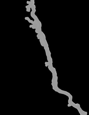
These vector contour lines are derived from the 3D Elevation Program using automated and semi-automated processes. They were created to support 1:24,000-scale topographic map products, but are also published in this GIS vector format. Contour intervals are assigned by 7.5-minute quadrangle, so this vector dataset is not visually seamless across quadrangle boundaries. The vector lines have elevation attributes (in feet above mean sea level on NAVD88), but this dataset does not carry line symbols or annotation.

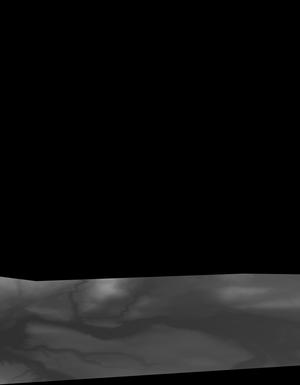
This tile of the National Elevation Dataset (NED) is 1/9 arc-second resolution. The National Elevation Dataset (NED) serves the elevation layer of The National Map, and provides basic elevation information for earth science studies and mapping applications in the United States. Scientists and resource managers use NED data for global change research, hydrologic modeling, resource monitoring, mapping and visualization, and many other applications. The NED is an elevation dataset that consists of seamless layers and a high resolution layer. Each of these layers are composed of the best available raster elevation data of the conterminous United States, Alaska, Hawaii, territorial islands, Mexico and Canada. The NED...

This tile of the National Elevation Dataset (NED) is 1/9 arc-second resolution. The National Elevation Dataset (NED) serves the elevation layer of The National Map, and provides basic elevation information for earth science studies and mapping applications in the United States. Scientists and resource managers use NED data for global change research, hydrologic modeling, resource monitoring, mapping and visualization, and many other applications. The NED is an elevation dataset that consists of seamless layers and a high resolution layer. Each of these layers are composed of the best available raster elevation data of the conterminous United States, Alaska, Hawaii, territorial islands, Mexico and Canada. The NED...

This tile of the National Elevation Dataset (NED) is 1/9 arc-second resolution. The National Elevation Dataset (NED) serves the elevation layer of The National Map, and provides basic elevation information for earth science studies and mapping applications in the United States. Scientists and resource managers use NED data for global change research, hydrologic modeling, resource monitoring, mapping and visualization, and many other applications. The NED is an elevation dataset that consists of seamless layers and a high resolution layer. Each of these layers are composed of the best available raster elevation data of the conterminous United States, Alaska, Hawaii, territorial islands, Mexico and Canada. The NED...

This tile of the National Elevation Dataset (NED) is 1/9 arc-second resolution. The National Elevation Dataset (NED) serves the elevation layer of The National Map, and provides basic elevation information for earth science studies and mapping applications in the United States. Scientists and resource managers use NED data for global change research, hydrologic modeling, resource monitoring, mapping and visualization, and many other applications. The NED is an elevation dataset that consists of seamless layers and a high resolution layer. Each of these layers are composed of the best available raster elevation data of the conterminous United States, Alaska, Hawaii, territorial islands, Mexico and Canada. The NED...
This tile of the National Elevation Dataset (NED) is 1/9 arc-second resolution. The National Elevation Dataset (NED) serves the elevation layer of The National Map, and provides basic elevation information for earth science studies and mapping applications in the United States. Scientists and resource managers use NED data for global change research, hydrologic modeling, resource monitoring, mapping and visualization, and many other applications. The NED is an elevation dataset that consists of seamless layers and a high resolution layer. Each of these layers are composed of the best available raster elevation data of the conterminous United States, Alaska, Hawaii, territorial islands, Mexico and Canada. The NED...

This tile of the National Elevation Dataset (NED) is 1/9 arc-second resolution. The National Elevation Dataset (NED) serves the elevation layer of The National Map, and provides basic elevation information for earth science studies and mapping applications in the United States. Scientists and resource managers use NED data for global change research, hydrologic modeling, resource monitoring, mapping and visualization, and many other applications. The NED is an elevation dataset that consists of seamless layers and a high resolution layer. Each of these layers are composed of the best available raster elevation data of the conterminous United States, Alaska, Hawaii, territorial islands, Mexico and Canada. The NED...

This tile of the National Elevation Dataset (NED) is 1/9 arc-second resolution. The National Elevation Dataset (NED) serves the elevation layer of The National Map, and provides basic elevation information for earth science studies and mapping applications in the United States. Scientists and resource managers use NED data for global change research, hydrologic modeling, resource monitoring, mapping and visualization, and many other applications. The NED is an elevation dataset that consists of seamless layers and a high resolution layer. Each of these layers are composed of the best available raster elevation data of the conterminous United States, Alaska, Hawaii, territorial islands, Mexico and Canada. The NED...

This tile of the National Elevation Dataset (NED) is 1/9 arc-second resolution. The National Elevation Dataset (NED) serves the elevation layer of The National Map, and provides basic elevation information for earth science studies and mapping applications in the United States. Scientists and resource managers use NED data for global change research, hydrologic modeling, resource monitoring, mapping and visualization, and many other applications. The NED is an elevation dataset that consists of seamless layers and a high resolution layer. Each of these layers are composed of the best available raster elevation data of the conterminous United States, Alaska, Hawaii, territorial islands, Mexico and Canada. The NED...

This tile of the National Elevation Dataset (NED) is 1/9 arc-second resolution. The National Elevation Dataset (NED) serves the elevation layer of The National Map, and provides basic elevation information for earth science studies and mapping applications in the United States. Scientists and resource managers use NED data for global change research, hydrologic modeling, resource monitoring, mapping and visualization, and many other applications. The NED is an elevation dataset that consists of seamless layers and a high resolution layer. Each of these layers are composed of the best available raster elevation data of the conterminous United States, Alaska, Hawaii, territorial islands, Mexico and Canada. The NED...

This tile of the National Elevation Dataset (NED) is 1/9 arc-second resolution. The National Elevation Dataset (NED) serves the elevation layer of The National Map, and provides basic elevation information for earth science studies and mapping applications in the United States. Scientists and resource managers use NED data for global change research, hydrologic modeling, resource monitoring, mapping and visualization, and many other applications. The NED is an elevation dataset that consists of seamless layers and a high resolution layer. Each of these layers are composed of the best available raster elevation data of the conterminous United States, Alaska, Hawaii, territorial islands, Mexico and Canada. The NED...

This tile of the National Elevation Dataset (NED) is 1/9 arc-second resolution. The National Elevation Dataset (NED) serves the elevation layer of The National Map, and provides basic elevation information for earth science studies and mapping applications in the United States. Scientists and resource managers use NED data for global change research, hydrologic modeling, resource monitoring, mapping and visualization, and many other applications. The NED is an elevation dataset that consists of seamless layers and a high resolution layer. Each of these layers are composed of the best available raster elevation data of the conterminous United States, Alaska, Hawaii, territorial islands, Mexico and Canada. The NED...

This tile of the National Elevation Dataset (NED) is 1/9 arc-second resolution. The National Elevation Dataset (NED) serves the elevation layer of The National Map, and provides basic elevation information for earth science studies and mapping applications in the United States. Scientists and resource managers use NED data for global change research, hydrologic modeling, resource monitoring, mapping and visualization, and many other applications. The NED is an elevation dataset that consists of seamless layers and a high resolution layer. Each of these layers are composed of the best available raster elevation data of the conterminous United States, Alaska, Hawaii, territorial islands, Mexico and Canada. The NED...

This tile of the National Elevation Dataset (NED) is 1/9 arc-second resolution. The National Elevation Dataset (NED) serves the elevation layer of The National Map, and provides basic elevation information for earth science studies and mapping applications in the United States. Scientists and resource managers use NED data for global change research, hydrologic modeling, resource monitoring, mapping and visualization, and many other applications. The NED is an elevation dataset that consists of seamless layers and a high resolution layer. Each of these layers are composed of the best available raster elevation data of the conterminous United States, Alaska, Hawaii, territorial islands, Mexico and Canada. The NED...

This tile of the National Elevation Dataset (NED) is 1/9 arc-second resolution. The National Elevation Dataset (NED) serves the elevation layer of The National Map, and provides basic elevation information for earth science studies and mapping applications in the United States. Scientists and resource managers use NED data for global change research, hydrologic modeling, resource monitoring, mapping and visualization, and many other applications. The NED is an elevation dataset that consists of seamless layers and a high resolution layer. Each of these layers are composed of the best available raster elevation data of the conterminous United States, Alaska, Hawaii, territorial islands, Mexico and Canada. The NED...

This tile of the National Elevation Dataset (NED) is 1/9 arc-second resolution. The National Elevation Dataset (NED) serves the elevation layer of The National Map, and provides basic elevation information for earth science studies and mapping applications in the United States. Scientists and resource managers use NED data for global change research, hydrologic modeling, resource monitoring, mapping and visualization, and many other applications. The NED is an elevation dataset that consists of seamless layers and a high resolution layer. Each of these layers are composed of the best available raster elevation data of the conterminous United States, Alaska, Hawaii, territorial islands, Mexico and Canada. The NED...

This tile of the National Elevation Dataset (NED) is 1/9 arc-second resolution. The National Elevation Dataset (NED) serves the elevation layer of The National Map, and provides basic elevation information for earth science studies and mapping applications in the United States. Scientists and resource managers use NED data for global change research, hydrologic modeling, resource monitoring, mapping and visualization, and many other applications. The NED is an elevation dataset that consists of seamless layers and a high resolution layer. Each of these layers are composed of the best available raster elevation data of the conterminous United States, Alaska, Hawaii, territorial islands, Mexico and Canada. The NED...

This tile of the National Elevation Dataset (NED) is 1/9 arc-second resolution. The National Elevation Dataset (NED) serves the elevation layer of The National Map, and provides basic elevation information for earth science studies and mapping applications in the United States. Scientists and resource managers use NED data for global change research, hydrologic modeling, resource monitoring, mapping and visualization, and many other applications. The NED is an elevation dataset that consists of seamless layers and a high resolution layer. Each of these layers are composed of the best available raster elevation data of the conterminous United States, Alaska, Hawaii, territorial islands, Mexico and Canada. The NED...

This tile of the National Elevation Dataset (NED) is 1/9 arc-second resolution. The National Elevation Dataset (NED) serves the elevation layer of The National Map, and provides basic elevation information for earth science studies and mapping applications in the United States. Scientists and resource managers use NED data for global change research, hydrologic modeling, resource monitoring, mapping and visualization, and many other applications. The NED is an elevation dataset that consists of seamless layers and a high resolution layer. Each of these layers are composed of the best available raster elevation data of the conterminous United States, Alaska, Hawaii, territorial islands, Mexico and Canada. The NED...
This tile of the National Elevation Dataset (NED) is 1/9 arc-second resolution. The National Elevation Dataset (NED) serves the elevation layer of The National Map, and provides basic elevation information for earth science studies and mapping applications in the United States. Scientists and resource managers use NED data for global change research, hydrologic modeling, resource monitoring, mapping and visualization, and many other applications. The NED is an elevation dataset that consists of seamless layers and a high resolution layer. Each of these layers are composed of the best available raster elevation data of the conterminous United States, Alaska, Hawaii, territorial islands, Mexico and Canada. The NED...
|

|
