Filters
Date Range
Extensions
Types
Contacts
Categories
Tag Types
Tag Schemes
|

The USGS Protected Areas Database of the United States (PAD-US) is the nation's inventory of protected areas, including public open space and voluntarily provided, private protected areas, identified as an A-16 National Geospatial Data Asset in the Cadastral Theme (http://www.fgdc.gov/ngda-reports/NGDA_Datasets.html). PAD-US is an ongoing project with several published versions of a spatial database of areas dedicated to the preservation of biological diversity, and other natural, recreational or cultural uses, managed for these purposes through legal or other effective means. The geodatabase maps and describes public open space and other protected areas. Most areas are public lands owned in fee; however, long-term...
Types: Citation;
Tags: Agricultural Research Service,
Alabama (AL),
Alaska (AK),
American Samoa (AS),
Arizona (AZ), All tags...
Arkansas (AR),
Army Corps of Engineers,
Biodiversity,
Bureau of Indian Affairs,
Bureau of Land Management,
Bureau of Reclamation,
Cadastre Theme,
California (CA),
Colorado (CO),
Connecticut (CT),
Conservation,
Delaware (DE),
Department of Defense,
Department of Energy,
Federal Lands,
Federated States of Micronesia (FM),
Florida (FL),
Forest Service,
GAP Status Code,
Gap Analysis,
Georgia (GA),
Governmental Units,
Guam (GU),
Hawaii (HI),
IUCN Category,
Idaho (ID),
Illinois (IL),
Indiana (IN),
Iowa (IA),
Kansas (KS),
Kentucky (KY),
Land Manager,
Land Ownership,
Land Stewardship,
Local Government Lands,
Louisiana (LA),
Maine (ME),
Mariana Islands (MP),
Marshall Islands (MH),
Maryland (MD),
Massachusetts (MA),
Michigan (MI),
Minnesota (MN),
Mississippi (MS),
Missouri (MO),
Montana (MT),
NGDA,
NGDA Portfolio Themes,
NGDA Portfolio Themes,
National Geospatial Data Asset,
National Oceanic and Atmospheric Administration,
National Park Service,
Natural Resources Conservation Service,
Nebraska (NE),
Nevada (NV),
New Hampshire (NH),
New Jersey (NJ),
New Mexico (NM),
New York (NY),
North Carolina (NC),
North Dakota (ND),
Ohio (OH),
Oklahoma (OK),
Oregon (OR),
Outdoor Recreation,
Palau (PW),
Parks,
Pennsylvania (PA),
Private Lands,
Protected Area,
Protection Status,
Public Health,
Public Lands,
Public Open Space,
Puerto Rico (PR),
Rhode Island (RI),
South Carolina (SC),
South Dakota (SD),
State Lands,
Tennessee (TN),
Tennessee Valley Authority,
Texas (TX),
U.S. Fish & Wildlife Service,
U.S. Fish and Wildlife Service,
U.S. Minor Outlying Islands (UM),
United States,
United States,
United States Virgin Islands (VI),
Utah (UT),
Vermont (VT),
Virginia (VA),
Washington (WA),
West Virginia (WV),
Wisconsin (WI),
Wyoming (WY), Fewer tags

USGS developed The National Map (TNM) Gazetteer as the Federal and national standard (ANSI INCITS 446-2008) for geographic nomenclature based on the Geographic Names Information System (GNIS). The National Map Gazetteer contains information about physical and cultural geographic features, geographic areas, and locational entities that are generally recognizable and locatable by name (have achieved some landmark status) and are of interest to any level of government or to the public for any purpose that would lead to the representation of the feature in printed or electronic maps and/or geographic information systems. The dataset includes features of all types in the United States, its associated areas, and Antarctica,...
Types: Citation;
Tags: BGN,
Cultural Resources Theme,
GNIS,
Geographic Names,
NGDA, All tags...
NGP-TNM,
National Geospatial Data Asset,
Overlay Map Service,
REST,
US,
United States,
WFS,
WMS,
a-16,
administrative,
board on geographic names,
cemetery,
community,
cultural,
cultural resource,
feature id,
federal,
gazetteer,
geographic,
governmental unit,
historical,
hydrography,
inlandWaters,
landform,
location,
name,
place,
populated place,
society,
statistical,
structure,
structure,
toponomy,
toponym,
toponymic,
transportation,
variant name,
water, Fewer tags

The USGS National Hydrography Dataset (NHD) service from The National Map (TNM) is a comprehensive set of digital spatial data that encodes information about naturally occurring and constructed bodies of surface water (lakes, ponds, and reservoirs), paths through which water flows (canals, ditches, streams, and rivers), and related entities such as point features (springs, wells, stream gages, and dams). The information encoded about these features includes classification and other characteristics, delineation, geographic name, position and related measures, a "reach code" through which other information can be related to the NHD, and the direction of water flow. The network of reach codes delineating water and...
Types: Citation;
Tags: HU,
Hydrography,
NGDA,
NGP-TNM,
NHD, All tags...
National Geospatial Data Asset,
Overlay Map Service,
REST,
US,
United States,
WBD,
WMS,
Water Inland Theme,
a-16,
basin,
canal,
dam,
ditch,
drainage,
gage,
gaging station,
hydrography,
hydrologic unit,
inlandWaters,
lake,
marsh,
pond,
region,
reservoir,
river,
spring,
stream,
subbasin,
subregion,
subwatershed,
swamp,
water,
water - inland,
watershed,
well, Fewer tags
Note: A new version of these statistics based on PAD-US 2.0 will be made available in 2020 here. This summary of the Protected Areas Database of the United States (PAD-US) is created to provide land managers and decision makers with a general summary of management for conservation, natural resource management and recreation. Area statistics include total acreage, acres by managing agency and percent protection. These summaries are available for the nation and by state. The PAD-US 1.4 Combined feature class (with Marine Protected Areas removed) was modified to remove overlaps, avoiding overestimation in protected area statistic summaries. A Python scripted process prioritized overlapping designations (for example,...
Types: Citation;
Tags: Acreage,
Acres,
Agricultural Research Service,
Alabama (AL),
Alaska (AK), All tags...
American Samoa (AS),
Area,
Arizona (AZ),
Arkansas (AR),
Army Corps of Engineers,
Biodiversity,
Bureau of Indian Affairs,
Bureau of Land Management,
Bureau of Reclamation,
Cadastre Theme,
California (CA),
Colorado (CO),
Connecticut (CT),
Conservation,
Delaware (DE),
Department of Defense,
Department of Energy,
Federal Lands,
Federated States of Micronesia (FM),
Florida (FL),
Forest Service,
GAP Status,
GAP Status Code,
Gap Analysis,
Georgia (GA),
Governmental Units,
Guam (GU),
Hawaii (HI),
IUCN Category,
Idaho (ID),
Illinois (IL),
Indiana (IN),
Iowa (IA),
Kansas (KS),
Kentucky (KY),
LCC,
LCC's,
Land Area,
Land Manager,
Land Managers,
Land Ownership,
Land Stewardship,
Landscape Conservation Cooperatives,
Local Government Lands,
Louisiana (LA),
Maine (ME),
Management Area,
Mariana Islands (MP),
Marshall Islands (MH),
Maryland (MD),
Massachusetts (MA),
Michigan (MI),
Minnesota (MN),
Mississippi (MS),
Missouri (MO),
Montana (MT),
NGDA,
NGDA Portfolio Themes,
National Geospatial Data Asset,
National Oceanic and Atmospheric Administration,
National Park Service,
Natural Resources Conservation Service,
Nebraska (NE),
Nevada (NV),
New Hampshire (NH),
New Jersey (NJ),
New Mexico (NM),
New York (NY),
North Carolina (NC),
North Dakota (ND),
Ohio (OH),
Oklahoma (OK),
Oregon (OR),
Outdoor Recreation,
Palau (PW),
Parks,
Pennsylvania (PA),
Percent Protected,
Private Lands,
Protected Area,
Protection Status,
Public Access,
Public Health,
Public Lands,
Public Open Space,
Puerto Rico (PR),
Rhode Island (RI),
South Carolina (SC),
South Dakota (SD),
State Lands,
Statistics,
Tennessee (TN),
Tennessee Valley Authority,
Texas (TX),
Total management,
U.S. Fish & Wildlife Service,
U.S. Fish and Wildlife Service,
U.S. Minor Outlying Islands (UM),
United States,
United States,
United States Virgin Islands (VI),
Utah (UT),
Vermont (VT),
Virginia (VA),
Washington (WA),
West Virginia (WV),
Wisconsin (WI),
Wyoming (WY),
counties,
ecoregions,
states, Fewer tags

The USGS Protected Areas Database of the United States (PAD-US) is the nation's inventory of protected areas, including public open space and voluntarily provided, private protected areas, identified as an A-16 National Geospatial Data Asset in the Cadastral Theme (http://www.fgdc.gov/ngda-reports/NGDA_Datasets.html). PAD-US is an ongoing project with several published versions of a spatial database of areas dedicated to the preservation of biological diversity, and other natural, recreational or cultural uses, managed for these purposes through legal or other effective means. The geodatabase maps and describes public open space and other protected areas. Most areas are public lands owned in fee; however, long-term...
Types: Citation;
Tags: Agricultural Research Service,
Alabama (AL),
Alaska (AK),
American Samoa (AS),
Arizona (AZ), All tags...
Arkansas (AR),
Army Corps of Engineers,
Biodiversity,
Bureau of Indian Affairs,
Bureau of Land Management,
Bureau of Reclamation,
Cadastre Theme,
California (CA),
Colorado (CO),
Connecticut (CT),
Conservation,
Delaware (DE),
Department of Defense,
Department of Energy,
Federal Lands,
Federated States of Micronesia (FM),
Florida (FL),
Forest Service,
GAP Status Code,
Gap Analysis,
Georgia (GA),
Governmental Units,
Guam (GU),
Hawaii (HI),
IUCN Category,
Idaho (ID),
Illinois (IL),
Indiana (IN),
Iowa (IA),
Kansas (KS),
Kentucky (KY),
Land Manager,
Land Ownership,
Land Stewardship,
Local Government Lands,
Louisiana (LA),
Maine (ME),
Mariana Islands (MP),
Marshall Islands (MH),
Maryland (MD),
Massachusetts (MA),
Michigan (MI),
Minnesota (MN),
Mississippi (MS),
Missouri (MO),
Montana (MT),
NGDA,
NGDA Portfolio Themes,
NGDA Portfolio Themes,
National Geospatial Data Asset,
National Oceanic and Atmospheric Administration,
National Park Service,
Natural Resources Conservation Service,
Nebraska (NE),
Nevada (NV),
New Hampshire (NH),
New Jersey (NJ),
New Mexico (NM),
New York (NY),
North Carolina (NC),
North Dakota (ND),
Ohio (OH),
Oklahoma (OK),
Oregon (OR),
Outdoor Recreation,
Palau (PW),
Parks,
Pennsylvania (PA),
Private Lands,
Protected Area,
Protection Status,
Public Health,
Public Lands,
Public Open Space,
Puerto Rico (PR),
Rhode Island (RI),
South Carolina (SC),
South Dakota (SD),
State Lands,
Tennessee (TN),
Tennessee Valley Authority,
Texas (TX),
U.S. Fish & Wildlife Service,
U.S. Fish and Wildlife Service,
U.S. Minor Outlying Islands (UM),
United States,
United States,
United States Virgin Islands (VI),
Utah (UT),
Vermont (VT),
Virginia (VA),
Washington (WA),
West Virginia (WV),
Wisconsin (WI),
Wyoming (WY), Fewer tags
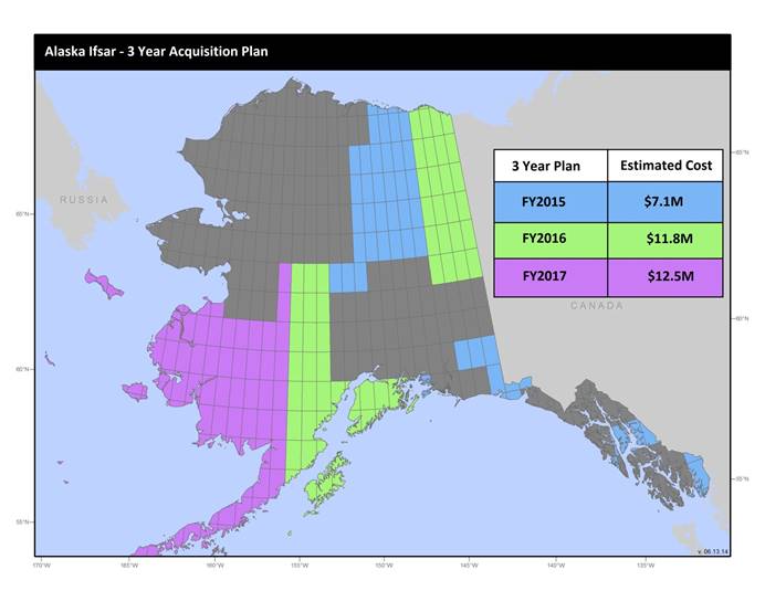
U.S. Geological Survey, Department of the Interior - The annual Alaska IfSAR and DEM acquisition plan is part of the 3DEP initiative to collect high-quality elevation data in the form of interferometric synthetic aperture radar (IfSAR) and light detection and ranging (lidar) data over Alaska. This acquisition plan addresses concerns raised in GAO Report 13-94 regarding geospatial coordination, and supports FGDC data coordination initiatives led by the Department of Interior's Geospatial Information Officer. Mapping a State the size and complexity of Alaska through a partnered effort such as the Alaska Mapping Initiative requires dedicated collaboration and coordination across multiple levels of government. State...
Types: Citation;
Tags: 3DEP,
Alaska,
Alaska Mapping Initiative,
DEM,
Elevation, All tags...
Elevation Theme,
IfSAR,
LAS,
NED,
NGDA,
National Elevation Dataset,
National Geospatial Data Asset,
acquisition plan,
airborne lidar,
contour,
elevation,
elevation,
lidar,
point cloud,
remote sensing,
topography, Fewer tags
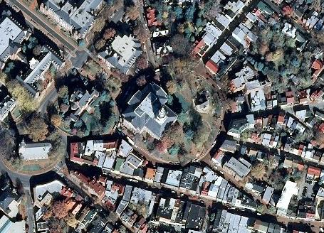
USGS_EROS_Ortho_SCALE service contains orthorectified digital aerial photographs and satellite imagery that are commonly referred to as orthoimagery. The imagery in this service is derived from high resolution images that combine the visual attributes of an aerial photograph with the spatial accuracy and geometric characteristics of a map. The resolution is primarily 1-meter, and the source imagery is acquired through partnerships with U.S. Department of Agriculture’s Farm Service Agency and other cooperating Federal, State, and local agencies. One meter resolution imagery means that each pixel in the orthoimage covers one meter on the earth’s surface. TNM_Large_Scale_Imagery service data is viewed at scales of...
Types: Citation;
Tags: HRO,
Imagery Theme,
JPEG 2000,
NAIP,
NGDA, All tags...
NGP-TNM,
National Geospatial Data Asset,
Orthoimagery,
Overlay Map Service,
REST,
US,
United States,
WMS,
a-16,
imagery,
imageryBaseMapsEarthCover,
jp2,
orthoimagery, Fewer tags

The USGS Protected Areas Database of the United States (PAD-US) is the nation's inventory of protected areas, including public open space and voluntarily provided, private protected areas, identified as an A-16 National Geospatial Data Asset in the Cadastral Theme (http://www.fgdc.gov/ngda-reports/NGDA_Datasets.html). PAD-US is an ongoing project with several published versions of a spatial database of areas dedicated to the preservation of biological diversity, and other natural, recreational or cultural uses, managed for these purposes through legal or other effective means. The geodatabase maps and describes public open space and other protected areas. Most areas are public lands owned in fee; however, long-term...
Types: Citation;
Tags: Agricultural Research Service,
Alabama (AL),
Alaska (AK),
American Samoa (AS),
Arizona (AZ), All tags...
Arkansas (AR),
Army Corps of Engineers,
Biodiversity,
Bureau of Indian Affairs,
Bureau of Land Management,
Bureau of Reclamation,
Cadastre Theme,
California (CA),
Colorado (CO),
Connecticut (CT),
Conservation,
Delaware (DE),
Department of Defense,
Department of Energy,
Federal Lands,
Federated States of Micronesia (FM),
Florida (FL),
Forest Service,
GAP Status Code,
Gap Analysis,
Georgia (GA),
Governmental Units,
Guam (GU),
Hawaii (HI),
IUCN Category,
Idaho (ID),
Illinois (IL),
Indiana (IN),
Iowa (IA),
Kansas (KS),
Kentucky (KY),
Land Manager,
Land Ownership,
Land Stewardship,
Local Government Lands,
Louisiana (LA),
Maine (ME),
Mariana Islands (MP),
Marshall Islands (MH),
Maryland (MD),
Massachusetts (MA),
Michigan (MI),
Minnesota (MN),
Mississippi (MS),
Missouri (MO),
Montana (MT),
NGDA,
NGDA Portfolio Themes,
NGDA Portfolio Themes,
National Geospatial Data Asset,
National Oceanic and Atmospheric Administration,
National Park Service,
Natural Resources Conservation Service,
Nebraska (NE),
Nevada (NV),
New Hampshire (NH),
New Jersey (NJ),
New Mexico (NM),
New York (NY),
North Carolina (NC),
North Dakota (ND),
Ohio (OH),
Oklahoma (OK),
Oregon (OR),
Outdoor Recreation,
Palau (PW),
Parks,
Pennsylvania (PA),
Private Lands,
Protected Area,
Protection Status,
Public Health,
Public Lands,
Public Open Space,
Puerto Rico (PR),
Rhode Island (RI),
South Carolina (SC),
South Dakota (SD),
State Lands,
Tennessee (TN),
Tennessee Valley Authority,
Texas (TX),
U.S. Fish & Wildlife Service,
U.S. Fish and Wildlife Service,
U.S. Minor Outlying Islands (UM),
United States,
United States,
United States Virgin Islands (VI),
Utah (UT),
Vermont (VT),
Virginia (VA),
Washington (WA),
West Virginia (WV),
Wisconsin (WI),
Wyoming (WY), Fewer tags
|
|

