Filters: Tags: National Geospatial Data Asset (X) > Date Range: {"choice":"year"} (X)
40 results (32ms)|
Filters
Date Types (for Date Range)
Types Contacts
Categories Tag Types Tag Schemes
|

The National Geologic Map Database (NGMDB) is a Congressionally mandated national archive of geoscience maps, reports, and stratigraphic information. The Geologic Mapping Act of 1992 and its Reauthorizations calls for the U.S. Geological Survey and the Association of American State Geologists (AASG) to cooperatively build this national archive, according to technical and scientific standards whose development is coordinated by the NGMDB. The NGMDB consists of a comprehensive set of publication citations, stratigraphic nomenclature, downloadable content in raster and vector formats, unpublished source information, and guidance on standards development. The NGMDB contains information on more than 110,000 maps and...
The U.S. Geological Survey (USGS), in partnership with several federal agencies, has developed and released five National Land Cover Database (NLCD) products over the past two decades: NLCD 1992, 2001, 2006, 2011, and 2016. The 2016 release saw landcover created for additional years of 2003, 2008, and 2013. These products provide spatially explicit and reliable information on the Nation’s land cover and land cover change. To continue the legacy of NLCD and further establish a long-term monitoring capability for the Nation’s land resources, the USGS has designed a new generation of NLCD products named NLCD 2019. The NLCD 2019 design aims to provide innovative, consistent, and robust methodologies for production of...
As part of the next generation NLCD 2016 mapping process, the NLCD research team developed a suite of intermediate products that were used to generate the final NLCD Land Cover products. Some of those products also have value as independent products and are provided here. Please read the product descriptions to understand what the product represents. Questions about the NLCD 2016 land cover product can be directed to the NLCD 2016 land cover mapping team at USGS EROS, Sioux Falls, SD (605) 594-6151 or mrlc@usgs.gov. See included spatial metadata for more details.
Types: Map Service,
OGC WFS Layer,
OGC WMS Layer,
OGC WMS Service;
Tags: GIS,
Image processing,
Land Use Land Cover Theme,
Land cover,
N.L.C.D.,
The U.S. Geological Survey (USGS), in partnership with several federal agencies, has now developed and released seven National Land Cover Database (NLCD) products: NLCD 1992, 2001, 2006, 2011, 2016, 2019, and 2021. Beginning with the 2016 release, land cover products were created for two-to-three-year intervals between 2001 and the most recent year. These products provide spatially explicit and reliable information on the Nation’s land cover and land cover change. NLCD continues to provide innovative, consistent, and robust methodologies for production of a multi-temporal land cover and land cover change database. The NLCD 2021 release is update based, so the Land Cover and Impervious Surface products released in...
The U.S. Geological Survey (USGS), in partnership with several federal agencies, has developed and released four National Land Cover Database (NLCD) products over the past two decades: NLCD 1992, 2001, 2006, and 2011. These products provide spatially explicit and reliable information on the Nation’s land cover and land cover change. To continue the legacy of NLCD and further establish a long-term monitoring capability for the Nation’s land resources, the USGS has designed a new generation of NLCD products named NLCD 2016. The NLCD 2016 design aims to provide innovative, consistent, and robust methodologies for production of a multi-temporal land cover and land cover change database from 2001 to 2016 at 2–3-year...
Categories: Data Release - Revised;
Types: Map Service,
OGC WFS Layer,
OGC WMS Layer,
OGC WMS Service;
Tags: GIS,
Image processing,
Land Use Land Cover Theme,
Land cover,
NGDA,

The National Hydrography Dataset (NHD) is a feature-based database that interconnects and uniquely identifies the stream segments or reaches that make up the nation's surface water drainage system. NHD data was originally developed at 1:100,000-scale and exists at that scale for the whole country. This high-resolution NHD, generally developed at 1:24,000/1:12,000 scale, adds detail to the original 1:100,000-scale NHD. (Data for Alaska, Puerto Rico and the Virgin Islands was developed at high-resolution, not 1:100,000 scale.) Local resolution NHD is being developed where partners and data exist. The NHD contains reach codes for networked features, flow direction, names, and centerline representations for areal water...
Categories: Data;
Types: Citation;
Tags: Administrative watershed units,
Area of Complex Channels,
Area to be submerged,
Basin,
Bay/Inlet,
The 2020 North American Land Cover 30-meter dataset was produced as part of the North American Land Change Monitoring System (NALCMS), a trilateral effort between Natural Resources Canada, the United States Geological Survey, and three Mexican organizations including the National Institute of Statistics and Geography (Instituto Nacional de Estadística y Geografía), National Commission for the Knowledge and Use of the Biodiversity (Comisión Nacional Para el Conocimiento y Uso de la Biodiversidad), and the National Forestry Commission of Mexico (Comisión Nacional Forestal). The collaboration is facilitated by the Commission for Environmental Cooperation, an international organization created by the Canada, Mexico,...
This update to the Alaska National Land Cover Database (NLCD) 2016 replaces the files dated 20200213. In this update the landcover footprint was extended along the northern coast to include the islands that were missed in previous versions, and several duplicate roads (offset by 1 or 2 pixels) were removed on the Aleutian Islands. The Alaska National Land Cover Database 2016 was created using change detection between the nominal dates of 2011 and 2016 utilizing Google Earth engine composites of Landsat imagery. Traditionally, previous classifications of Alaska used path row data and spectral comparisons between path rows along with ancillary data to derive areas of change. Alaska has many challenges for land cover...
The U.S. Geological Survey (USGS), in partnership with several federal agencies, has developed and released four National Land Cover Database (NLCD) products over the past two decades: NLCD 1992, 2001, 2006, and 2011. These products provide spatially explicit and reliable information on the Nation’s land cover and land cover change. To continue the legacy of NLCD and further establish a long-term monitoring capability for the Nation’s land resources, the USGS has designed a new generation of NLCD products named NLCD 2016. The NLCD 2016 design aims to provide innovative, consistent, and robust methodologies for production of a multi-temporal land cover and land cover change database from 2001 to 2016 at 2–3-year...
Types: Map Service,
OGC WFS Layer,
OGC WMS Layer,
OGC WMS Service;
Tags: GIS,
Image processing,
Land Use Land Cover Theme,
Land cover,
NGDA,
The U.S. Geological Survey (USGS), in partnership with several federal agencies, has now developed and released seven National Land Cover Database (NLCD) products: NLCD 1992, 2001, 2006, 2011, 2016, 2019, and 2021. Beginning with the 2016 release, land cover products were created for two-to-three-year intervals between 2001 and the most recent year. These products provide spatially explicit and reliable information on the Nation’s land cover and land cover change. NLCD continues to provide innovative, consistent, and robust methodologies for production of a multi-temporal land cover and land cover change database. The NLCD 2021 release is update based, so the Land Cover and Impervious Surface products released in...
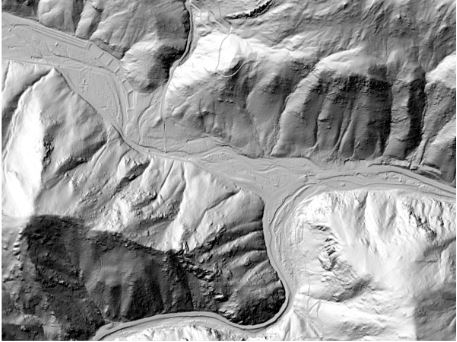
This is a tiled collection of the 3D Elevation Program (3DEP) and is one meter resolution. The 3DEP data holdings serve as the elevation layer of The National Map, and provide foundational elevation information for earth science studies and mapping applications in the United States. Scientists and resource managers use 3DEP data for hydrologic modeling, resource monitoring, mapping and visualization, and many other applications. The elevations in this DEM represent the topographic bare-earth surface. USGS standard one-meter DEMs are produced exclusively from high resolution light detection and ranging (lidar) source data of one-meter or higher resolution. One-meter DEM surfaces are seamless within collection projects,...
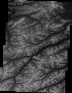
5 Meter Alaska Digital Elevation Models (DEMs) - USGS National Map 3DEP Downloadable Data Collection
This is a tiled collection of the 3D Elevation Program (3DEP) covering Alaska only, and is 5-meter resolution. The 3DEP data holdings serve as the elevation layer of The National Map, and provide foundational elevation information for earth science studies and mapping applications in the United States. Scientists and resource managers use 3DEP data for hydrologic modeling, resource monitoring, mapping and visualization, and many other applications. The elevations in this DEM represent the topographic bare-earth surface. USGS standard 5-meter DEMs are produced exclusively from interferometric synthetic aperture radar (Ifsar) source data of 5-meter or higher resolution. Five-meter DEM surfaces are seamless within...
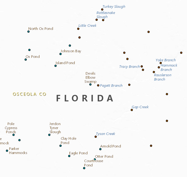
The Geographic Names Information System (GNIS) is the Federal standard for geographic nomenclature. The U.S. Geological Survey developed the GNIS for the U.S. Board on Geographic Names, a Federal inter-agency body chartered by public law to maintain uniform feature name usage throughout the Government and to promulgate standard names to the public. The GNIS is the official repository of domestic geographic names data; the official vehicle for geographic names use by all departments of the Federal Government; and the source for applying geographic names to Federal electronic and printed products of all types. See https://www.usgs.gov/board-on-geographic-names for additional information.
The U.S. Geological Survey (USGS), in partnership with several federal agencies, has developed and released five National Land Cover Database (NLCD) products over the past two decades: NLCD 1992, 2001, 2006, 2011, and 2016. The 2016 release saw landcover created for additional years of 2003, 2008, and 2013. These products provide spatially explicit and reliable information on the Nation’s land cover and land cover change. To continue the legacy of NLCD and further establish a long-term monitoring capability for the Nation’s land resources, the USGS has designed a new generation of NLCD products named NLCD 2019. The NLCD 2019 design aims to provide innovative, consistent, and robust methodologies for production of...
The LANDFIRE vegetation layers describe the following elements of existing and potential vegetation for each LANDFIRE mapping zone: environmental site potentials, biophysical settings, existing vegetation types, canopy cover, and vegetation height. Vegetation is mapped using predictive landscape models based on extensive field reference data, satellite imagery, biophysical gradient layers, and classification and regression trees. The environmental site potential (ESP) data layer represents the vegetation that could be supported at a given site based on the biophysical environment. Map units are named according to NatureServe's Ecological Systems classification, which is a nationally consistent set of mid-scale ecological...
As part of the next generation NLCD 2016 mapping process, the NLCD research team developed a suite of intermediate products that were used to generate the final NLCD Land Cover products. Some of those products also have value as independent products and are provided here. Please read the product descriptions to understand what the product represents.
Types: Map Service,
OGC WFS Layer,
OGC WMS Layer,
OGC WMS Service;
Tags: GIS,
Image processing,
Land Use Land Cover Theme,
Land cover,
N.L.C.D.,
The U.S. Geological Survey (USGS), in partnership with several federal agencies, has developed and released four National Land Cover Database (NLCD) products over the past two decades: NLCD 1992, 2001, 2006, and 2011. These products provide spatially explicit and reliable information on the Nation’s land cover and land cover change. To continue the legacy of NLCD and further establish a long-term monitoring capability for the Nation’s land resources, the USGS has designed a new generation of NLCD products named NLCD 2016. The NLCD 2016 design aims to provide innovative, consistent, and robust methodologies for production of a multi-temporal land cover and land cover change database from 2001 to 2016 at 2–3-year...
Types: Map Service,
OGC WFS Layer,
OGC WMS Layer,
OGC WMS Service;
Tags: GIS,
Image processing,
Land Use Land Cover Theme,
Land cover,
NGDA,
The Moderate Resolution Imaging Spectroradiometer, or MODIS, sensor resides aboard the Terra and Aqua platforms, offering a view the Earth's surface every 1-2 days. The MODIS sensor collects data within 36 spectral bands, ranging in wavelengths from 0.4 µm to 14.4 µm and provides us with imagery at a nominal resolution of 250 m at nadir for two bands, 500 m resolution for 5 bands, and the remaining 29 bands at 1 km. Many data products are derived from MODIS/Terra including surface reflectance, emissivity, land surface temperature, vegetation indices, thermal anomalies and fire, leaf area index, and evapotranspiration. This metadata record is intended to represent the mission as a whole and to direct consumers to...
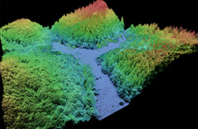
This data collection of the 3D Elevation Program (3DEP) consists of Lidar Point Cloud (LPC) projects as provided to the USGS. These point cloud files contain all the original lidar points collected, with the original spatial reference and units preserved. These data may have been used as the source of updates to the 1/3-arcsecond, 1-arcsecond, and 2-arcsecond seamless 3DEP Digital Elevation Models (DEMs). The 3DEP data holdings serve as the elevation layer of The National Map, and provide foundational elevation information for earth science studies and mapping applications in the United States. Lidar (Light detection and ranging) discrete-return point cloud data are available in LAZ format. The LAZ format is a lossless...
The Advanced Spaceborne Thermal Emission and Reflection Radiometer (ASTER) is one of five state-of-the-art instrument sensor systems operating on the Terra spacecraft. The Terra satellite was launched on December 18, 1999. Terra flies in a sun-synchronous polar orbit, crossing the equator at 10:30 a.m. Eastern Standard Time (EST). ASTER utilizes a unique combination of wide spectral coverage and high spatial resolution in the visible near-infrared through shortwave infrared to the thermal infrared regions. It is a partnership between NASA, Japan's Ministry of Economy, Trade and Industry (METI), the National Institute of Advanced Industrial Science and Technology (AIST) in Japan, and Japan Space Systems (J-spacesystems)....
|

|
