Filters: Tags: National Geospatial Data Asset (X)
166 results (58ms)|
Filters
Date Range
Extensions Types
Contacts
Categories Tag Types Tag Schemes |
The 2010 North American Land Cover data set was produced as part of the NorthAmerican Land Change Monitoring System (NALCMS), a trilateral effort between theCanada Centre for Remote Sensing, the United States Geological Survey, and threeMexican organizations including the National Institute of Statistics and Geography(Instituto Nacional de Estadistica y Geografia), National Commission for theKnowledge and Use of the Biodiversity (Comisión Nacional Para el Conocimiento yUso de la Biodiversidad), and the National Forestry Commission of Mexico (ComisiónNacional Forestal). The collaboration is facilitated by the Commission forEnvironmental Cooperation, an international organization created by the Canada,Mexico, and...
The U.S. Geological Survey (USGS), in partnership with several federal agencies, has now developed and released seven National Land Cover Database (NLCD) products: NLCD 1992, 2001, 2006, 2011, 2016, 2019, and 2021. Beginning with the 2016 release, land cover products were created for two-to-three-year intervals between 2001 and the most recent year. These products provide spatially explicit and reliable information on the Nation’s land cover and land cover change. NLCD continues to provide innovative, consistent, and robust methodologies for production of a multi-temporal land cover and land cover change database. The NLCD 2021 release is update based, so the Land Cover and Impervious Surface products released in...
The Fire Regime Groups layer characterizes the presumed historical fire regimes within landscapes based on interactions between vegetation dynamics, fire spread, fire effects, and spatial context (Hann and others 2004). Fire regime group definitions have been altered from previous applications (Hann & Bunnell 2001; Schmidt and others 2002; Wildland Fire Communicator's Guide) to best approximate the definitions outlined in the Interagency FRCC Guidebook. These definitions were refined to create discrete, mutually exclusive criteria. This layer was created by linking the LANDFIRE Biophysical Settings (BpS) layer to the Fire Regime Group rulesets. This geospatial product should display a reasonable approximation of...
The LANDFIRE fuel data describe the composition and characteristics of both surface fuel and canopy fuel. Specific products include fire behavior fuel models, canopy bulk density (CBD), canopy base height (CBH), canopy cover (CC), canopy height (CH), and fuel loading models (FLMs). These data may be implemented within models to predict the behavior and effects of wildland fire. These data are useful for strategic fuel treatment prioritization and tactical assessment of fire behavior and effects. CC describes percent cover of tree canopy in a stand. A spatially-explicit map of canopy cover supplies information for fire behavior models such as FARSITE (Finney 1998) to determine surface fuel shading for calculating...

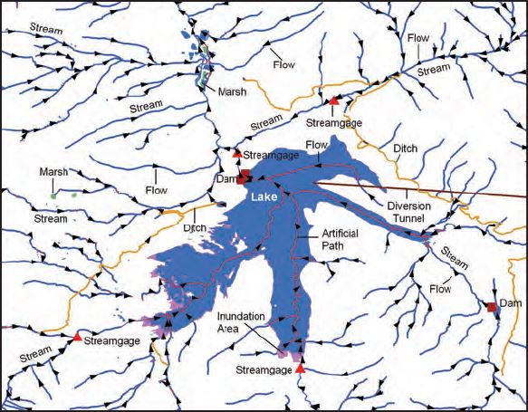
USGS Hydro-NHD is a tile cache base map that combines hydrography data in The National Map from the National Hydrography Dataset (NHD) along with the Watershed Boundary Dataset (WBD). The NHD is a comprehensive set of digital spatial data that encodes information about naturally occurring and constructed bodies of surface water (lakes, ponds, and reservoirs), paths through which water flows (canals, ditches, streams, and rivers), and related entities such as point features (springs, wells, stream gages, and dams). The information encoded about these features includes classification and other characteristics, delineation, geographic name, position and related measures, a "reach code" through which other information...
U.S. Geological Survey, Department of the Interior - The annual National Hydrography Dataset (NHD) stewardship plan is to maintain hydrography data in the NHD over the United States and its territories. NHD for the nation has been collected and is now in maintenance mode. Interested parties who wish to become a NHD stewardship partner with the USGS in FY17 or in future years should contact a USGS Geospatial Liaison - http://liaisons.usgs.gov/geospatial/documents/TNM_Partnership_User_ContactList.pdf. To find out more about hydrography stewardship go to http://nhd.usgs.gov/stewardship.html or for exact project status information on areas currently in work go to http://nhd.usgs.gov/project_status.html
Types: Citation;
Tags: Hydrography,
NGDA,
NHD,
National Geospatial Data Asset,
National Hydrography Dataset,
Feature level Dataset for the BLM Administrative Unit Boundaries Data Standard. This feature dataset includes both BLM administrative land areas and office locations. Land areas are depicted with polygons for the smallest administrative unit (field offices). Larger administrative units, such as district offices, and administrative states may be derived from these polygons. Office locations at each level are depicted with points. This dataset is a subset of the official national dataset, containing features and attributes intended for public release and has been optimized for online map service performance. The Implementation Guide represents the official national dataset from which this dataset was derived.
The USGS Protected Areas Database of the United States (PAD-US) is the nation's inventory of protected areas, including public open space and voluntarily provided, private protected areas, identified as an A-16 National Geospatial Data Asset in the Cadastral Theme (http://www.fgdc.gov/ngda-reports/NGDA_Datasets.html). PAD-US is an ongoing project with several published versions of a spatial database of areas dedicated to the preservation of biological diversity, and other natural, recreational or cultural uses, managed for these purposes through legal or other effective means. The geodatabase maps and describes public open space and other protected areas. Most areas are public lands owned in fee; however, long-term...
Types: Citation;
Tags: Agricultural Research Service,
Alabama (AL),
Alaska (AK),
American Samoa (AS),
Arizona (AZ),
|

|
