Filters: Tags: Niagara Falls (X)
78 results (125ms)|
Filters
Date Range
Extensions Types Contacts
Categories Tag Types Tag Schemes |
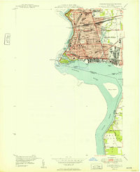
USGS Historical Quadrangle in GeoPDF.
Surface of Lockport Limestone in bed of old channel between Dufferin Islands, Niagara Falls. Province of Ontario, Canada. 1898.
Categories: Image;
Types: Map Service,
OGC WFS Layer,
OGC WMS Layer,
OGC WMS Service;
Tags: Gilbert, G.K. Collection,
Hillers J.K. Collection Niagara Falls,
National Parks,
Niagara Falls,
Photographers,
Surface of Lockport Limestone exposed in old water channel between Dufferin Islands, Niagara Falls. Province of Ontario, Canada. 1898.
Categories: Image;
Types: Map Service,
OGC WFS Layer,
OGC WMS Layer,
OGC WMS Service;
Tags: Gilbert, G.K. Collection,
Hillers J.K. Collection Niagara Falls,
National Parks,
Niagara Falls,
Photographers,
This data set contains imagery from the National Agriculture Imagery Program (NAIP). The NAIP program is administered by USDA FSA and has been established to support two main FSA strategic goals centered on agricultural production. These are, increase stewardship of America's natural resources while enhancing the environment, and to ensure commodities are procured and distributed effectively and efficiently to increase food security. The NAIP program supports these goals by acquiring and providing ortho imagery that has been collected during the agricultural growing season in the U.S. The NAIP ortho imagery is tailored to meet FSA requirements and is a fundamental tool used to support FSA farm and conservation programs....
This data set contains imagery from the National Agriculture Imagery Program (NAIP). The NAIP program is administered by USDA FSA and has been established to support two main FSA strategic goals centered on agricultural production. These are, increase stewardship of America's natural resources while enhancing the environment, and to ensure commodities are procured and distributed effectively and efficiently to increase food security. The NAIP program supports these goals by acquiring and providing ortho imagery that has been collected during the agricultural growing season in the U.S. The NAIP ortho imagery is tailored to meet FSA requirements and is a fundamental tool used to support FSA farm and conservation programs....

Historic image LS_0500 is part of the 'UVA lantern slides' collection; the topic area is 'Niagara Falls'. Location is NY (imprecise). The image has the following description: 'View showing the rapids looking down stream .' The image was scanned from a lantern slide as part of the USGS NGGDPP deliverable for 2017-2018. The physical location is 900 Natural Resources Dr., Ste 400, Charlottesville, VA 22903. Library. The author is unknown. The image is dated unknown.

Historic image LS_0419 is part of the 'UVA lantern slides' collection; the topic area is 'Niagara Falls'. Location is NY (imprecise). The image has the following description: 'Earliest use of Niagara power .' The image was scanned from a lantern slide as part of the USGS NGGDPP deliverable for 2017-2018. The physical location is 900 Natural Resources Dr., Ste 400, Charlottesville, VA 22903. Library. The author is unknown. The image is dated unknown.
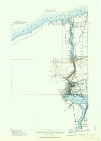
USGS Historical Quadrangle in GeoPDF.
Peculiar structure of Lockport Limestone exposed by quarrying in bed of old channels between Dufferin Islands, Niagara Falls. Province of Ontario, Canada. 1898.
Categories: Image;
Types: Map Service,
OGC WFS Layer,
OGC WMS Layer,
OGC WMS Service;
Tags: Gilbert, G.K. Collection,
Hillers J.K. Collection Niagara Falls,
National Parks,
Niagara Falls,
Photographers,
Niagara Falls, New York and Canada. New carriage and electric railroad bridge, viewed from the American side, showing the character of the water surface and also the maturity of the talus slope, as indicated by forest growth. Circa 1895.
Categories: Image;
Tags: Hillers J.K. Collection Niagara Falls,
National Parks,
Niagara Falls,
Railroad,
photo print

Historic image LS_0486 is part of the 'UVA lantern slides' collection; the topic area is 'Niagara Falls'. Location is NY (imprecise). The image has the following description: 'The crest line from Prospect Point. .' The image was scanned from a lantern slide as part of the USGS NGGDPP deliverable for 2017-2018. The physical location is 900 Natural Resources Dr., Ste 400, Charlottesville, VA 22903. Library. The author is unknown. The image is dated unknown.

Historic image LS_0495 is part of the 'UVA lantern slides' collection; the topic area is 'Niagara Falls'. Location is NY (imprecise). The image has the following description: 'The river above the whirlpool. .' The image was scanned from a lantern slide as part of the USGS NGGDPP deliverable for 2017-2018. The physical location is 900 Natural Resources Dr., Ste 400, Charlottesville, VA 22903. Library. The author is unknown. The image is dated unknown.

Historic image LS_0488 is part of the 'UVA lantern slides' collection; the topic area is 'Niagara Falls'. Location is NY (imprecise). The image has the following description: 'Interior power house no. 1 .' The image was scanned from a lantern slide as part of the USGS NGGDPP deliverable for 2017-2018. The physical location is 900 Natural Resources Dr., Ste 400, Charlottesville, VA 22903. Library. The author is unknown. The image is dated unknown.

Historic image LS_0502 is part of the 'UVA lantern slides' collection; the topic area is 'Niagara Falls'. Location is NY (imprecise). The image has the following description: 'The river below the whirlpool. From high up on Canadian side. .' The image was scanned from a lantern slide as part of the USGS NGGDPP deliverable for 2017-2018. The physical location is 900 Natural Resources Dr., Ste 400, Charlottesville, VA 22903. Library. The author is unknown. The image is dated unknown.

Historic image LS_0535 is part of the 'UVA lantern slides' collection; the topic area is 'Niagara Falls'. Location is NY (imprecise). The image has the following description: 'Niagara Gorge near Lewiston, Medina group. .' The image was scanned from a lantern slide as part of the USGS NGGDPP deliverable for 2017-2018. The physical location is 900 Natural Resources Dr., Ste 400, Charlottesville, VA 22903. Library. The author is unknown. The image is dated unknown.

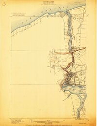
USGS Historical Quadrangle in GeoPDF.
USGS Historical Quadrangle in GeoPDF.
Curved slab of Lockport Limestone from bed of old channel between Dufferin Islands, Niagara Falls. Shows surface markings. (One-half natural size). Province of Ontario, Canada. 1898.
Categories: Image;
Types: Map Service,
OGC WFS Layer,
OGC WMS Layer,
OGC WMS Service;
Tags: Gilbert, G.K. Collection,
Hillers J.K. Collection Niagara Falls,
National Parks,
Niagara Falls,
Photographers,
|

|
