Filters: Tags: North Pacific (X) > partyWithName: North Pacific LCC Data Coordinator (X)
5 results (11ms)|
Filters
Date Range
Tag Schemes |
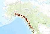
Subalpine Connectivity of areas of high elevation and high human footprint in the North Pacific Landscape Conservation Cooperative study area. This application provides Subalpine Connectivity for 2000 and 2080 (A1B). The North Pacific Forest Landscape Connectivity Project uses three main geospatial layers as inputs into the creation of resistance map grids.  One-km was decided as the resolution for the final resistance grids.  The three primary geospatial layers used in this analysis were a digital elevation model (DEM), a vegetation layer, and a human footprint layer.  Due to the geographic extent of the North Pacific Landscape Conservation Cooperative, digital elevation models from different sources had to...

Subalpine Connectivity of areas of low elevation and low human footprint in the North Pacific Landscape Conservation Cooperative study area. This application provides Subalpine Connectivity for 2000 and 2080 (A1B).The North Pacific Forest Landscape Connectivity Project uses three main geospatial layers as inputs into the creation of resistance map grids. One-km was decided as the resolution for the final resistance grids. The three primary geospatial layers used in this analysis were a digital elevation model (DEM), a vegetation layer, and a human footprint layer. Due to the geographic extent of the North Pacific Landscape Conservation Cooperative, digital elevation models from different sources had to be...

Montane Conifer Connectivity of areas of high elevation and high human footprint in the North Pacific Landscape Conservation Cooperative study area. This application provides Montane Conifer Connectivity for 2000 and 2080 (A1B). The North Pacific Forest Landscape Connectivity Project uses three main geospatial layers as inputs into the creation of resistance map grids. One-km was decided as the resolution for the final resistance grids. The three primary geospatial layers used in this analysis were a digital elevation model (DEM), a vegetation layer, and a human footprint layer. Due to the geographic extent of the North Pacific Landscape Conservation Cooperative, digital elevation models from different sources...
Montane Conifer Connectivity of areas of low elevation and low human footprint in the North Pacific Landscape Conservation Cooperative study area. This application provides Montane Conifer Connectivity for 2000 and 2080 (A1B). The North Pacific Forest Landscape Connectivity Project uses three main geospatial layers as inputs into the creation of resistance map grids. One-km was decided as the resolution for the final resistance grids. The three primary geospatial layers used in this analysis were a digital elevation model (DEM), a vegetation layer, and a human footprint layer. Due to the geographic extent of the North Pacific Landscape Conservation Cooperative, digital elevation models from different sources...

The Riverscape Analysis Project (RAP) is a web-based GIS Decision Support System that was designed to assist in salmon conservation across North Pacific Rim (NPR) Rivers. RAP is based upon a robust classification (typology) of rivers and river habitats which is aimed at mapping habitat quality and abundance, as well as conserving the existing potential production of salmon and the rivers that they spawn and rear in. Key elements of the RAP system include relative habitat rankings, GIS tools to extract and download data, a subset of high resolution remote sensing imagery, and models of salmon habitat suitability based on current and future climate scenarios.
|

|
