Filters: Tags: Northern Mariana Islands (X)
156 results (57ms)|
Filters
Date Range
Extensions Types Contacts
Categories Tag Types
|

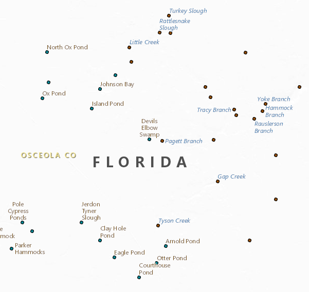
The National Hydrography Dataset (NHD) is a feature-based database that interconnects and uniquely identifies the stream segments or reaches that make up the nation's surface water drainage system. NHD data was originally developed at 1:100,000-scale and exists at that scale for the whole country. This high-resolution NHD, generally developed at 1:24,000/1:12,000 scale, adds detail to the original 1:100,000-scale NHD. (Data for Alaska, Puerto Rico and the Virgin Islands was developed at high-resolution, not 1:100,000 scale.) Local resolution NHD is being developed where partners and data exist. The NHD contains reach codes for networked features, flow direction, names, and centerline representations for areal water...

Geospatial data includes structures and other selected map features.

The Watershed Boundary Dataset (WBD) is a comprehensive aggregated collection of hydrologic unit data consistent with the national criteria for delineation and resolution. It defines the areal extent of surface water drainage to a point except in coastal or lake front areas where there could be multiple outlets as stated by the "Federal Standards and Procedures for the National Watershed Boundary Dataset (WBD)" "Standard" (https://pubs.usgs.gov/tm/11/a3/). Watershed boundaries are determined solely upon science-based hydrologic principles, not favoring any administrative boundaries or special projects, nor particular program or agency. This dataset represents the hydrologic unit boundaries to the 12-digit (6th level)...

The Watershed Boundary Dataset (WBD) is a comprehensive aggregated collection of hydrologic unit data consistent with the national criteria for delineation and resolution. It defines the areal extent of surface water drainage to a point except in coastal or lake front areas where there could be multiple outlets as stated by the "Federal Standards and Procedures for the National Watershed Boundary Dataset (WBD)" "Standard" (https://pubs.usgs.gov/tm/11/a3/). Watershed boundaries are determined solely upon science-based hydrologic principles, not favoring any administrative boundaries or special projects, nor particular program or agency. This dataset represents the hydrologic unit boundaries to the 12-digit (6th level)...

The Geographic Names Information System (GNIS) is the Federal standard for geographic nomenclature. The U.S. Geological Survey developed the GNIS for the U.S. Board on Geographic Names, a Federal inter-agency body chartered by public law to maintain uniform feature name usage throughout the Government and to promulgate standard names to the public. The GNIS is the official repository of domestic geographic names data; the official vehicle for geographic names use by all departments of the Federal Government; and the source for applying geographic names to Federal electronic and printed products of all types.

Geospatial data includes structures and other selected map features.
Chronic Wasting Disease distribution in the United States by state and county (ver. 2.0, April 2024)
Chronic Wasting Disease (CWD) is a fatal, contagious, neuro-degenerative disease affecting multiple members of the Family Cervidae. First detected in 1967, the disease has, as of April 2024, been documented in free-ranging and/or captive cervid populations in 33 states, five Canadian provinces, the Republic of South Korea, Norway, Sweden, and Finland. The data provided here contains information on the known, available, documented distribution of CWD in the United States that is current as of the publication date. The USGS National Wildlife Health Center (NWHC) tracks changes to the known distribution of CWD in the form of a map (available on the NWHC website at https://www.usgs.gov/centers/nwhc/science/expanding-distribution-chronic-wasting-disease....
Categories: Data,
Data Release - Revised;
Types: Citation;
Tags: Alabama,
Alaska,
American Samoa,
Arizona,
Arkansas,

Layers of geospatial data include contours, boundaries, land cover, hydrography, roads, transportation, geographic names, structures, and other selected map features.
Types: Citation;
Tags: 7.5 x 7.5 minute,
Combined Vector,
Combined Vector,
Downloadable Data,
FileGDB 10.1,
There are two datasets included in this entry. The diurnal dataset contains 28 columns of data collected during transects surveys. The nocturnal dataset contains 52 columns. We randomly select 56 sites, each 50 m in length, from 37,968 m of transects spanning the island that were originally created for bird surveys in 1982 through the cooperative efforts of the U.S. Fish and Wildlife Service, the Department of Natural Resources of CNMI, and the U.S. Forest Service. For diurnal surveys, 56 transects were surveyed twice per day for 1–3 consecutive days resulting in six survey occasions. For nocturnal surveys, we surveyed 51 of the 56 transects 4 times per night for 1–3 consecutive nights resulting in 12 survey occasions....
Categories: Data;
Tags: Northern Mariana Islands,
Saipan,
USGS Science Data Catalog (SDC),
amphibians,
biogeography,

Layers of geospatial data include contours, boundaries, land cover, hydrography, roads, transportation, geographic names, structures, and other selected map features.
Types: Citation;
Tags: 7.5 x 7.5 minute,
Combined Vector,
Combined Vector,
Downloadable Data,
FileGDB 10.1,

Layers of geospatial data include contours, boundaries, land cover, hydrography, roads, transportation, geographic names, structures, and other selected map features.
Types: Citation;
Tags: 7.5 x 7.5 minute,
Combined Vector,
Combined Vector,
Downloadable Data,
FileGDB 10.1,
The Geographic Names Information System (GNIS) is the Federal standard for geographic nomenclature. The U.S. Geological Survey developed the GNIS for the U.S. Board on Geographic Names, a Federal inter-agency body chartered by public law to maintain uniform feature name usage throughout the Government and to promulgate standard names to the public. The GNIS is the official repository of domestic geographic names data; the official vehicle for geographic names use by all departments of the Federal Government; and the source for applying geographic names to Federal electronic and printed products of all types. See https://www.usgs.gov/board-on-geographic-names for additional information.

Geospatial data includes structures and other selected map features.
Geospatial data is comprised of government boundaries.
The Geographic Names Information System (GNIS) is the Federal standard for geographic nomenclature. The U.S. Geological Survey developed the GNIS for the U.S. Board on Geographic Names, a Federal inter-agency body chartered by public law to maintain uniform feature name usage throughout the Government and to promulgate standard names to the public. The GNIS is the official repository of domestic geographic names data; the official vehicle for geographic names use by all departments of the Federal Government; and the source for applying geographic names to Federal electronic and printed products of all types.
Layers of geospatial data include roads, airports, trails, and railroads.
Alamagan Volcano is a Quaternary stratovolcano along the Mariana Arc, an active subduction zone in the western Pacific Ocean. Although primarily submerged, its peak reaches above sea level, with subaerially-exposed volcanic deposits dating back through the Holocene to the late Pleistocene. These feature data represent such deposits and other geologic features of Alamagan Volcano, describing its interpreted eruptive history.
Categories: Data;
Types: Downloadable,
Map Service,
OGC WFS Layer,
OGC WMS Layer,
Shapefile;
Tags: Alamagan Island,
Andesite,
Intermediate volcanic rock,
Lava flow,
MapUnitPolys,
The National Hydrography Dataset (NHD) is a feature-based database that interconnects and uniquely identifies the stream segments or reaches that make up the nation's surface water drainage system. NHD data was originally developed at 1:100,000-scale and exists at that scale for the whole country. This high-resolution NHD, generally developed at 1:24,000/1:12,000 scale, adds detail to the original 1:100,000-scale NHD. (Data for Alaska, Puerto Rico and the Virgin Islands was developed at high-resolution, not 1:100,000 scale.) Local resolution NHD is being developed where partners and data exist. The NHD contains reach codes for networked features, flow direction, names, and centerline representations for areal water...
The National Hydrography Dataset (NHD) is a feature-based database that interconnects and uniquely identifies the stream segments or reaches that make up the nation's surface water drainage system. NHD data was originally developed at 1:100,000-scale and exists at that scale for the whole country. This high-resolution NHD, generally developed at 1:24,000/1:12,000 scale, adds detail to the original 1:100,000-scale NHD. (Data for Alaska, Puerto Rico and the Virgin Islands was developed at high-resolution, not 1:100,000 scale.) Local resolution NHD is being developed where partners and data exist. The NHD contains reach codes for networked features, flow direction, names, and centerline representations for areal water...
The National Hydrography Dataset (NHD) is a feature-based database that interconnects and uniquely identifies the stream segments or reaches that make up the nation's surface water drainage system. NHD data was originally developed at 1:100,000-scale and exists at that scale for the whole country. This high-resolution NHD, generally developed at 1:24,000/1:12,000 scale, adds detail to the original 1:100,000-scale NHD. (Data for Alaska, Puerto Rico and the Virgin Islands was developed at high-resolution, not 1:100,000 scale.) Local resolution NHD is being developed where partners and data exist. The NHD contains reach codes for networked features, flow direction, names, and centerline representations for areal water...
|

|
