Filters: Tags: Okmok (X)
5 results (46ms)|
Filters
Date Range
Types Contacts
Tag Types Tag Schemes |
Okmok volcano, Aleutian Islands, Alaska, explosively erupted over a five-week period between July 12 and August 23, 2008. The eruption was predominantly phreatomagmatic, producing fine-grained tephra that covered most of northeastern Umnak Island. The eruption had a maximum Volcanic Explosivity Index (VEI) of 4, with eruption column heights up to 16 km during the opening phase. Several craters and a master tuff cone formed in the caldera as a result of phreatomagmatic explosions and accumulated tephra-fall and surge deposits. Ascending magma continuously interacted with an extensive shallow groundwater table in the caldera, resulting in the phreatomagmatic character of the eruption. Syneruptive explosion and collapse...
This publication contains previously unpublished geochemical analyses or re-analyses of lavas, magmatic inclusions, and a few gabbroic cumulate inclusions from Alaska volcanoes (Akutan, Augustine, Buzzard Creek, Dana, Douglas, Fourpeaked, Frosty, Great Sitkin, Iliamna, Kaguyak, Kiska, Okmok, Prindle Cone, Recheshnoi, Redoubt, Spurr, Ukinrek Maars, Vsevidof, Westdahl, Wrangell) collected by the authors and others over the past 35 years. It provides substantial data sets for three volcanoes (Vsevidof, Westdahl, and Douglas) for which little or no published data exist. All analyses were made by the GeoAnalytical laboratory at Washington State University in Pullman, WA. The ICP/MS data have been reduced using the 2006...
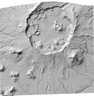
In response to significant morphologic changes in Okmok Caldera due to the phreatomagmatic eruption of Okmok volcano in 2009, a new digital elevation model was acquired to document and quantitatively assess the new volcanic features and altered hydrology within the caldera. This DEM dataset provides elevation data derived from a stereo pair of Worldview-1 satellite images acquired on January 21, 2010. In addition to the DEM, a shaded-relief image is also provided for easy visualization of the data.
This zip folder contains ASCII text files of vectors at the specified volcano at 12-hour intervals, from January 1, 1990 through December 28, 2009. The wind vectors are divided into five files, names by their elevation range above sea level in the atmosphere: 00-05km.txt; 05-11km.txt; 11-16km.txt; 16-24km.txt; and 24-30km.txt. The zip folder also contains a subfolder "figures", with Wind rose plots of wind direction and speed over this time period. The plots are by season, and by elevation, given a total of 20 plots (4 seasons, 5 elevation ranges). A summary plot is also included which gives the year-round wind pattern at the volcano, at 0-5 km elevation. Plots are in both jpg and pdf format.
This 30-meter, horizontal, cell-size, shaded relief, georeferenced TIFF image of Okmok Volcano, Umnak Island, Alaska, was created by combining digital elevation model (DEM) data provided by NASA's shuttle radar topography mission (SRTM) and the aircraft-mounted synthetic aperture radar (AirSAR) mission.
|

|
