Filters: Tags: Okmok Caldera (X) > partyWithName: Larsen, J.F. (X)
4 results (26ms)|
Okmok volcano, Aleutian Islands, Alaska, explosively erupted over a five-week period between July 12 and August 23, 2008. The eruption was predominantly phreatomagmatic, producing fine-grained tephra that covered most of northeastern Umnak Island. The eruption had a maximum Volcanic Explosivity Index (VEI) of 4, with eruption column heights up to 16 km during the opening phase. Several craters and a master tuff cone formed in the caldera as a result of phreatomagmatic explosions and accumulated tephra-fall and surge deposits. Ascending magma continuously interacted with an extensive shallow groundwater table in the caldera, resulting in the phreatomagmatic character of the eruption. Syneruptive explosion and collapse...
This dataset consists of the vector digital GIS files that were used to create sheet 1 of the "Preliminary volcano-hazard assessment for Okmok Volcano, Umnak Island, Alaska" (DGGS RI 2004-3). The map area is centered around Okmok Volcano, on eastern Umnak Island. The data includes volcano-hazard zones for ballistics, ash accumulation, pyroclastic flows, floods and lahars, and debris avalanches. Also included in the dataset are roads, trails, seismic station locations, continuous GPS station locations, creeks, and the location of the Fort Glenn airstrip.
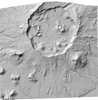
In response to significant morphologic changes in Okmok Caldera due to the phreatomagmatic eruption of Okmok volcano in 2009, a new digital elevation model was acquired to document and quantitatively assess the new volcanic features and altered hydrology within the caldera. This DEM dataset provides elevation data derived from a stereo pair of Worldview-1 satellite images acquired on January 21, 2010. In addition to the DEM, a shaded-relief image is also provided for easy visualization of the data.
This shaded relief image of Okmok Volcano serves as the basemap for sheet 1 of the "Preliminary volcano-hazard assessment for Okmok Volcano, Umnak Island, Alaska" (DGGS RI 2004-3). The map area is centered around Okmok Volcano, on eastern Umnak Island. SRTM and AirSAR DEM datasets were combined in ArcGIS to produce a georeferenced shaded relief TIFF image of Okmok Volcano.
|

|
