Filters: Tags: PMEP (X)
10 results (22ms)|
Filters
Date Range
Extensions Types Contacts
Categories Tag Types
|
This shapefile defines the two distinct zones within the 2013 boundary of the Pacific Marine and Estuarine Fish Habitat Partnership (PMEP), a recognized Fish Habitat Partnership (FHP) of the National Fish Habitat Partnership (NFHP). The two zones of the PMEP include the estuarine and marine nearshore complex (PMEP focus area, coastal subregions, and nearshore marine waters) of the states of California, Oregon, and Washington.
Categories: Data;
Types: ArcGIS REST Map Service,
ArcGIS Service Definition,
Downloadable,
Map Service;
Tags: Analytical boundary,
Aquatic habitats,
Boundaries,
California,
FHP Boundary,
Accruate mapping of tidal wetlands is vital for effective conservation and restoration of these valued habitats, and good mapping is key to strategic planning for coastal resilience. Tidal wetlands are defined by regular inundation by the tides; therefore, mapping of tidal wetlands should be based on knowledge of tidal water levels and the land areas inundated by the tides. We developed this tidal wetland mapping following that principle. Briefly, we used a method developed in Oregon that combines NOAA’s extreme water level models with high-resolution LIDAR digital elevation models (DEMs) to map areas subject to tidal inundation. We refined the mapping using additional data sources such as the National Wetland...
Categories: Data;
Types: ArcGIS REST Map Service,
Map Service;
Tags: FHP Product,
Habitat Characterization,
Hydrologic alteration,
Marine,
NFHP Cooperator,
This point layer represents estuaries present within PMEP’s spatial data system. This layer was developed by members of PMEP, based partly on previous estuary inventory efforts as well asthe goals of PMEP. Currently, there are 444 estuaries present in this layer, covering the West Coast of the contiguous United States. Estuaries were included based on their current or future potential to provide habitat for fish species. It is possible that this list will expand or contract over time, as determined by the needs of PMEP.
Categories: Data;
Types: ArcGIS REST Map Service,
Map Service;
Tags: FHP Product,
Habitat Characterization,
Marine,
NFHP Cooperator,
PMEP,
This shapefile is the official focus area of the Pacific Marine and Estuarine Fish Habitat Partnership (PMEP), a recognized Fish Habitat Partnership (FHP) of the National Fish Habitat Partnership (NFHP). The focus area lays within the partnership's larger area of interest or 'geographic scope' within and offshore of the states of California, Oregon, and Washington. The focus area boundary aims to highlight the nearshore marine and estuarine tidal waters.
Categories: Data;
Types: ArcGIS REST Map Service,
ArcGIS Service Definition,
Downloadable,
Map Service;
Tags: Analytical boundary,
Aquatic habitats,
Boundaries,
California,
FHP Boundary,
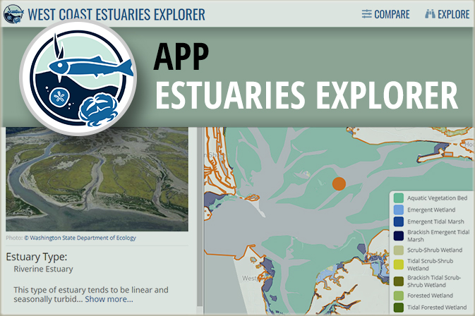
This application enables you to compare estuaries to each other along the coastlines of Washington, Oregon, and California. You can combine dynamic filters and an interactive map to find specific estuary types you are interested in, such as large river delta estuaries which often have extensive diking; small, riverine estuaries that are at the lowest risk to fish habitat degradation; or estuaries contain species that interest you. Only want to compare estuaries in a specific area? Simply zoom the map in to that area, and the filters automatically update to show you the number of estuaries in that area that meet different conditions. You can also explore estuaries in more detail to find a specific estuary by name...
This spatial data layer provides an indirect estimate of emergent, scrub-shrub and forested tidal wetland losses for 55 non-lagoonal estuaries spanning the contiguous United States West Coast. Losses are defined as those areas that were tidal wetlands prior to European settlement, but are no longer tidal wetlands today. Losses were estimated by comparing the National Wetland Inventory‘s mapping of current tidal wetlands to the Pacific Marine and Estuarine Fish Habitat Partnership (PMEP)’s West Coast Estuary Extent mapping. The estuary extent layer represents the likely historical extent of tidal wetlands, so areas not identified as current tidal wetlands in the National Wetlands Inventory (NWI) are considered...
Categories: Data;
Types: ArcGIS REST Map Service,
Map Service;
Tags: FHP Product,
Habitat Characterization,
Marine,
National Assessment,
PMEP,
This map viewer highlights spatial data products developed by PMEP to characterize habitats and synthesize information in support of habitat conservation and restoration goal setting. Most of the data presented in this viewer are available at https://www.pacificfishhabitat.org/data.
This shapefile is the 2013 official boundary of the Pacific Marine and Estuarine Fish Habitat Partnership (PMEP), a recognized Fish Habitat Partnership (FHP) of the National Fish Habitat Partnership (NFHP). The boundary, also known as the 'geographic scope', of the PMEP includes the estuarine and marine nearshore complex (PMEP focus area, coastal subregions, and nearshore marine waters) of the states of California, Oregon, and Washington. The seperate zones and area of focused interest are available as seperate boundary layers.
Categories: Data;
Types: ArcGIS REST Map Service,
ArcGIS Service Definition,
Downloadable,
Map Service;
Tags: Analytical boundary,
Aquatic habitats,
Boundaries,
California,
FHP Boundary,
Eelgrass is a type of marine, flowering seagrass that grows underwater in temperate marine environments around the world, and on the West coast includes three species: (1) Zostera marina, (2) non-native dwarf eelgrass, Zostera japonica, and (3) a distinct species to Southern California, Zostera pacifica. In 2014, TNC and PMEP produced the report, “Nursey Functions of U.S. West Coast Estuaries: The State of Knowledge for Juveniles of Focal Invertebrate and Fish Species,” which found that eelgrass (Zostera sp.) meadows are one of the most important juvenile habitats for a broad array of fish species. Understanding the spatial extent of eelgrass habitats in West Coast estuaries is important for restoration and conservation...
Categories: Data;
Types: ArcGIS REST Map Service,
Map Service;
Tags: FHP Product,
Habitat Characterization,
Marine,
NFHP Cooperator,
PMEP,
These data represent the Biotic Component (BC) of the Coastal and Marine Ecological Classification Standard (CMECS) for estuaries of the West Coast of the contiguous United States. The BC is organized into a branched hierarchy of five nested levels: biotic setting, biotic class, biotic subclass, biotic group, and biotic community. Classes and subclasses of the BC are determined by the dominant biota (defined as the most abundant in terms of percent cover) of the substrate. Following the methods developed by the Oregon Coastal Management Program (OCMP) – Oregon Department of Land Conservation and Development (https://www.coastalatlas.net/documents/cmecs/PhaseI/EPSM_CoreGISMethods.pdf), we cross-walked attributes...
Categories: Data;
Types: ArcGIS REST Map Service,
Map Service;
Tags: FHP Product,
Habitat Characterization,
Marine,
NFHP Cooperator,
PMEP,
|

|
