Filters: Tags: POTENTIAL (X)
60 results (29ms)|
Filters
Date Range
Extensions Types Contacts
Categories Tag Types Tag Schemes |
The application of post-combustion capture (PCC) processes in coal fired power stations can result in large reductions of the CO2-emissions, but the consequential decrease in generation efficiency is an important draw-back The leading PCC technology is based on chemical absorption processes as this technology is the one whose scale-up status is closest to full-scale capture in power plants The energy performance of this process is analysed in this contribution. The analysis shows that the potential for improvement of the energy performance is quite large It is demonstrated that further development of the capture technology and the power plant technology can lead to generation efficiencies for power plants with 90%...
Some theoretical results concerning the nature of the relationship between the scientific quality and economic value of imperfect weather forecasts are obtained. A prototype multistage decision-making model is considered, involving only two possible actions and two possible states of weather. This particular form of model is motivated by a real-world application known as the fruit-frost problem. For an infinite-horizon, discounted version of this model it is shown that economic value remains zero below a forecast quality threshold and then rises monotonically but nonlinearly above this threshold. In particular, the relative sensitivity of economic value to changes in the quality of forecasts increases as perfect...
Categories: Publication;
Types: Citation;
Tags: Quantifying,
energy,
photovoltaic,
policy,
potential,

This metadata references the polygonal ARC/INFO GIS cover showing the current and historic distribution of potential habitat, or range, of the Greater Sage-grouse (Centrocercus urophasianus) and Gunnison Sage-grouse (Centrocercus minimus) in Western North America. This data was initially researched and compiled by Dr. Michael A. Schroeder, research biologist for the Washington State Department of Fish and Wildlife. The initial draft of current and historic range data was mapped and submitted to state, federal, or provincial natural resource agencies and other experts for review, comment, and editing. The final product represents the best available science and expert review available at the time of compilation. ...

This metadata references the polygonal ARC/INFO GIS cover showing the current and historic distribution of potential habitat, or range, of the Greater Sage-grouse (Centrocercus urophasianus) and Gunnison Sage-grouse (Centrocercus minimus) in Western North America. This data was initially researched and compiled by Dr. Michael A. Schroeder, research biologist for the Washington State Department of Fish and Wildlife. The initial draft of current and historic range data was mapped and submitted to state, federal, or provincial natural resource agencies and other experts for review, comment, and editing. The final product represents the best available science and expert review available at the time of compilation. ...
Soil erosion potential due to water based on the RUSLE soil loss equation. These data are provided by Bureau of Land Management (BLM) "as is" and may contain errors or omissions. The User assumes the entire risk associated with its use of these data and bears all responsibility in determining whether these data are fit for the User's intended use. These data may not have the accuracy, resolution, completeness, timeliness, or other characteristics appropriate for applications that potential users of the data may contemplate. The User is encouraged to carefully consider the content of the metadata file associated with these data. The BLM should be cited as the data source in any products derived from these data.
This map shows conservation element summaries within areas of potential near-term and long-term energy development. These summaries help highlight areas of potential conflict between conservation elements and energy development. These data are provided by Bureau of Land Management (BLM) "as is" and may contain errors or omissions. The User assumes the entire risk associated with its use of these data and bears all responsibility in determining whether these data are fit for the User's intended use. These data may not have the accuracy, resolution, completeness, timeliness, or other characteristics appropriate for applications that potential users of the data may contemplate. The User is encouraged to carefully consider...
The biologically significant unit (BSUs) were revised in April 2019, creating the most up-to-date version of this dataset. A BSU is a geographical/spatial area within greater sage-grouse habitat that contains relevant and important habitats which is used as the basis for comparative calculations to support evaluation of changes to habitat. This BSU unit, or subset of this unit, is used in the calculation of the anthropogenic disturbance threshold and in the adaptive management habitat trigger. BSU feature classes were submitted by individual states/EISs and consolidated by the Wildlife Spatial Analysis Lab. They are sometimes referred to as core areas/core habitat areas in the explanations below, which were consolidated...
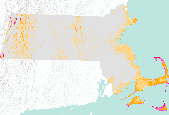
Annual average wind resource potential for the state of Massachusetts at a 50 meter height. Available from the National Renewable Energy Laboratory (NREL) at http://www.nrel.gov/renewable_resources/. This dataset was last updated on 3/2/09.

Annual average wind resource potential for the state of Ohio at a 50 meter height. Available from the National Renewable Energy Laboratory (NREL) at http://www.nrel.gov/renewable_resources/ . This dataset was last updated on 3/2/2009.
Nations must work together to minimize the risk of global warming. A worldwide energy efficiency campaign - led and coordinated by an International Energy Efficiency Agency (IEEA) - could be a critical component in such an effort. The IEEA could: I) strengthen energy efficiency efforts in industrialized countries; 2) help to build capability for implementing energy efficiency improvements in developing and East European countries; 3) provide capital for large-scale energy efficiency investments in developing and East European nations. Appropriate activities for the IEEA include information dissemination; joint R& D programrues; demonstration of technologies as well as policy instruments; training or supporting national...
Categories: Publication;
Types: Citation;
Tags: Estimates,
GHG emission reduction,
cost,
country,
potential,
National Renewable Energy Lab Photovoltaic Solar Potential within the ecoregion. These data are provided by Bureau of Land Management (BLM) "as is" and may contain errors or omissions. The User assumes the entire risk associated with its use of these data and bears all responsibility in determining whether these data are fit for the User's intended use. These data may not have the accuracy, resolution, completeness, timeliness, or other characteristics appropriate for applications that potential users of the data may contemplate. The User is encouraged to carefully consider the content of the metadata file associated with these data. The BLM should be cited as the data source in any products derived from these data.
State policies can support renewable energy development by driving markets, providing certainty in the investment market, and incorporating the external benefits of the technologies into cost/benefit calculations. Using statistical analyses and policy design best practices, this paper quantifies the impact of state-level policies on renewable energy development in order to better understand the role of policy on development and inform policy makers on the policy mechanisms that provide maximum benefit. The results include the identification of connections between state policies and renewable energy development, as well as a discussion placing state policy efforts in context with other factors that influence the...
Ecotourism has been proposed as a viable economic activity that can minimize negative human impacts on wildlife habitat and provide an incentive to preserve natural areas. The potential of ecotourism as a wildlife conservation strategy is limited by its inability to insure the long-term protection of environmental assets and by its tendency to contribute directly to environmental degradation. Ecotourism is a proxy market designed to align consumers' preferences for recreation with the protection of environmental assets. Because it does not necessarily address the direct protection of those assets, it is prone to market failure. Pressures on governments and firms involved in providing ecotourism services will impair...
Categories: Publication;
Types: Citation;
Tags: conservation,
contribute,
ecotourism,
potential,
wildlife

Annual average wind resource potential for the state of Hawaii at a 50 meter height. Available from the National Renewable Energy Laboratory (NREL) at http://www.nrel.gov/renewable_resources/ . This dataset was last updated on 6/04/2009.
National Renewable Energy Lab Direct Solar Potential within the ecoregion. These data are provided by Bureau of Land Management (BLM) "as is" and may contain errors or omissions. The User assumes the entire risk associated with its use of these data and bears all responsibility in determining whether these data are fit for the User's intended use. These data may not have the accuracy, resolution, completeness, timeliness, or other characteristics appropriate for applications that potential users of the data may contemplate. The User is encouraged to carefully consider the content of the metadata file associated with these data. The BLM should be cited as the data source in any products derived from these data.
Wyoming BSUs were revised in February 2018, creating the most up-to-date version of this dataset. Data submitted by Montana and Oregon in May 2016 was used to update an earlier version of this feature class. The biologically significant unit (BSU) is a geographical/spatial area within Greater Sage-Grouse habitat that contains relevant and important habitats which is used as the basis for comparative calculations to support evaluation of changes to habitat. This BSU unit, or subset of this unit is used in the calculation of the anthropogenic disturbance threshold and in the adaptive management habitat trigger. BSU feature classes were submitted by individual states/EISs and consolidated by the Wildlife Spatial Analysis...
This metadata references the polygonal ARC/INFO GIS cover showing the current and historic distribution of potential habitat, or range, of the Greater Sage-grouse (Centrocercus urophasianus) and Gunnison Sage-grouse (Centrocercus minimus) in Western North America. This data was initially researched and compiled by Dr. Michael A. Schroeder, research biologist for the Washington State Department of Fish and Wildlife. The initial draft of current and historic range data was mapped and submitted to state, federal, or provincial natural resource agencies and other experts for review, comment, and editing. The final product represents the best available science and expert review available at the time of compilation.Definition...
Categories: Data;
Types: Downloadable,
Map Service,
OGC WFS Layer,
OGC WMS Layer,
Shapefile;
Tags: Alberta,
Biology and Ecology,
Bird Conservation,
California,
Canada,
Yields of winter wheat, silage maize and grain maize in the main arable areas of the European Union (E.U.) were calculated with a simulation model, WOFOST, using historical weather data and average soil characteristics. The sensitivity of the model to individual weather variables was determined.Subsequent analyses were made using climate change scenarios with and without the direct effects of increased atmospheric CO 2. The impact of crop management in a changed climate was also assessed. The various climate change scenarios used appear to yield considerably different changes in yield, both for each location and for the E.U. as a whole.
Categories: Publication;
Types: Citation;
Tags: Effects,
European Union,
climate change,
corn,
crops,
The biologically significant units (BSUs) feature class was revised in April 2019, creating the most up-to-date version of this dataset. A BSU is a geographical/spatial area within Greater Sage-Grouse habitat that contains relevant and important habitats which is used as the basis for comparative calculations to support evaluation of changes to habitat. This BSU unit, or subset of this unit is used in the calculation of the anthropogenic disturbance threshold and in the adaptive management habitat trigger. BSU feature classes were submitted by individual states/EISs and consolidated by the Wildlife Spatial Analysis Lab. They are sometimes referred to as core areas/core habitat areas in the explanations below, which...
|

|
