Filters: Tags: Pasture (X)
14 results (62ms)|
Filters
Date Range
Extensions Types Contacts
Categories Tag Types
|
This is an aggregate dataset for the DRECP 12 km buffer region, depicting the geographic boundaries of Grazing Allotments within BLM managed public lands. An allotment is an area of land designated and managed for grazing of livestock (43 CFR 4100.0-5). An allotment may include private, state, and public lands under the jurisdiction of the Bureau of Land Management and/or other federal agencies. An allotment may be subdivided into pastures. Range improvement projects are not depicted within this dataset.
Lands within the watersheds of the Great Plains streams that are not used for crops are often used for cattle grazing and hay production. Northern Plains States are one of the nation’s top producers of cattle, which outnumber people almost three to one in North Dakota. Cattle can have direct habitat impacts by trampling stream banks, which destroys beneficial vegetation and increases sedimentation and nutrient loads. Hofmann and Ries (1991) found that livestock increased sediment runoff in North Dakota streams. Schepers and Francis (1982) reported that runoff from a Nebraska cattle farm increased total phosphorus levels in runoff by 37%. In addition, cattle watering ponds, often constructed by diverting streams,...
Types: Map Service,
OGC WFS Layer,
OGC WMS Layer,
OGC WMS Service;
Tags: 2015,
HumanActivity,
NorthernPlainsRegion,
NorthernPlainsStates,
Pasture
Annotated bibliography of grazing effects on amphibians and their habitats (ver. 2.0, February 2022)
This database contains literature citations and associated summaries pertaining to livestock grazing effects on amphibians and their habitats, with an emphasis on the Oregon spotted frog (Rana pretiosa) and other listed/sensitive wetland-breeding amphibians in the western United States. This is not meant to be an exhaustive list, nor did we perform a systematic meta-analysis; rather, literature records were included based on topical relevance. *HINT: If you are looking for the database SEARCH TOOL, scroll down to 'Attached Files' and download 'Annotated_bibliography_with_search_tool.accdb.' Open the database file to enter the search form.* This data release supersedes Rowe, J.C., Pearl, C.A., Adams, M.J., and McCreary,...
Categories: Data;
Tags: Aquatic Biology,
Ecology,
Land Use Change,
USGS Science Data Catalog (SDC),
Wildlife Biology,
A consolidated grazing dataset representing BLM and FS submissions, with ownership indicated in the 'Mngmnt' field. Overlaps are identified as "BLMFS". BLM - GSSP allotments and pastures merged, overlaps removed, and dissolved to one polygon. GSSP SNAPSHOT of Approved data set made on 5/14/12 for the Greater Sage-grouse baseline rangewide cumulative effects analysis. This aggregate national dataset identifies allotments within BLM managed public lands. FS - This allotment layer is a merged and dissolved representation of the 27 allotment data files submitted to the BLM by the USFS for the GRSG CEA. As needed, records with ‘Unit_Type’ = 1 were selected for the merge, while the remainder were omitted. Additionally,...

These data were released prior to the October 1, 2016 effective date for the USGS’s policy dictating the review, approval, and release of scientific data as referenced in USGS Survey Manual Chapter 502.8 Fundamental Science Practices: Review and Approval of Scientific Data for Release. This spatial data set was created by the U.S. Geological Survey (USGS) to represent the amount of phosphorus generated by pastured, non-cattle livestock that was applied to pasture land in the Pacific Northwest region of the United States (Hydro Region 17; Major River Basin 7 (MRB7)) during 2002.
Data can be accessed through a map service (select one of the options in the grey bar above the inset map) or viewed in the BLM's GeoCommunicator interactive map.
Categories: Data,
Web Site;
Types: ArcGIS REST Map Service,
Map Service;
Tags: Allotment,
BLM,
GRA,
Grazing,
Livestock,
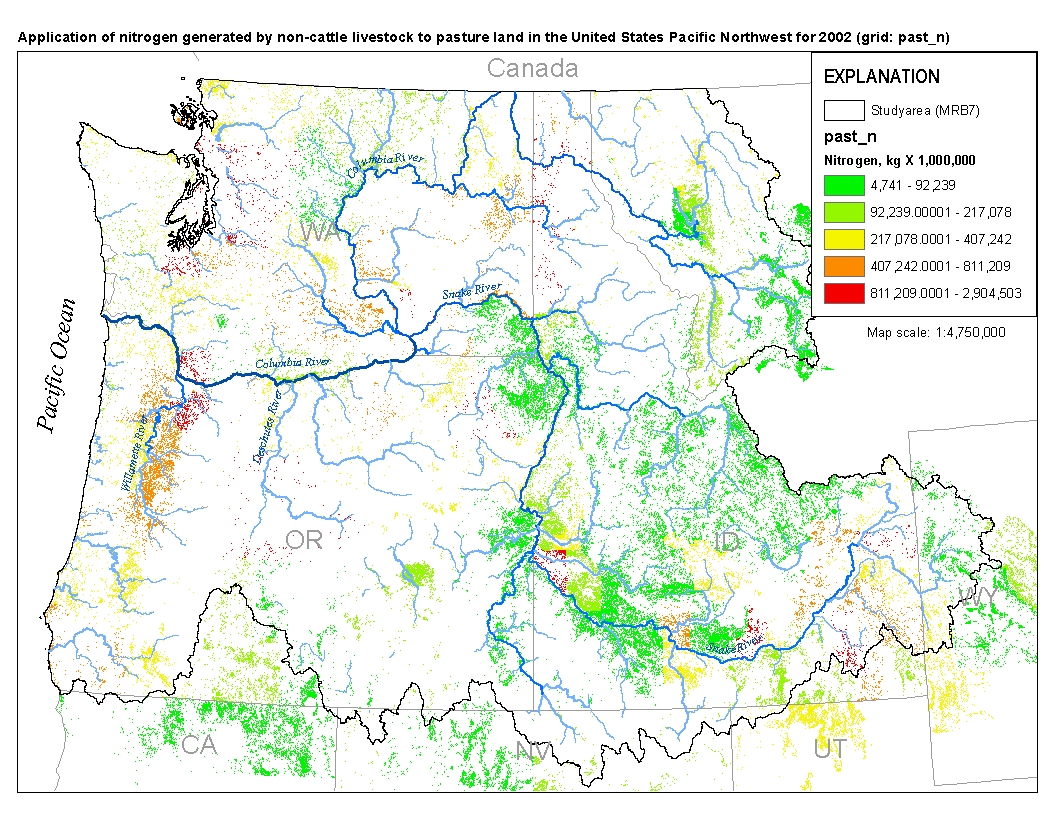
This spatial data set was created by the U.S. Geological Survey (USGS) to represent the amount of nitrogen generated by pastured, non-cattle livestock that was applied to pasture land in the Pacific Northwest region of the United States (Hydro Region 17; Major River Basin 7 (MRB7)) during 2002.
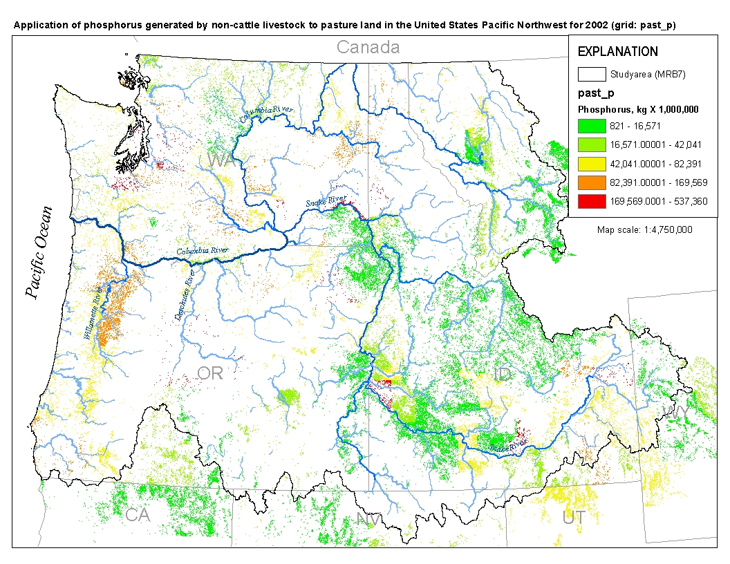
This spatial data set was created by the U.S. Geological Survey (USGS) to represent the amount of phosphorus generated by pastured, non-cattle livestock that was applied to pasture land in the Pacific Northwest region of the United States (Hydro Region 17; Major River Basin 7 (MRB7)) during 2002.
This fencing potential layer is a merged representation of the 27 allotment data files submitted to the BLM by the USFS for the GRSG CEA and the GSSP snapshot of approved BLM grazing data made on 5/24/2012. This aggregate national dataset identifies pasture and allotment borders, represented as linear features, within BLM and FS managed public lands. This dataset serves as a surrogate for fencing potential across BLM and FS managed lands. Pasture and allotment polygons were converted to linear features using the “Polygon to Line” tool in ArcGIS. To identify areas of overlap between the BLM and FS data, an intersect operation was performed. The results were used to erase the overlapping geometry to avoid double counting....
The response of biological nitrogen fixation (BNF) to elevated CO(2) was examined in white clover (Trifolium repens)-dominated swards under both high and low phosphorus availability. Mixed swards of clover and buffalo grass (Stenotaphrum secundatum) were grown for 15 months in 0.2 m2 sand-filled mesocosms under two CO2 treatments (ambient and twice ambient) and three nutrient treatments [no N, and either low or high P (5 or 134 kg P ha(-1)); the third nutrient treatment was supplied with high P and N (240 kg N ha(-1))]. Under ambient CO2, high P increased BNF from 410 to 900 kg ha(-1). Elevated CO2 further increased BNF to 1180 kg ha(-1) with high P, but there was no effect of CO2 on BNF with low P. Allocation of...
Categories: Publication;
Types: Citation,
Journal Citation;
Tags: New Phytologist,
Trifolium repens (white clover),
biological nitrogen fixation (BNF),
elevated CO2,
legume nitrogen,

These data were released prior to the October 1, 2016 effective date for the USGS’s policy dictating the review, approval, and release of scientific data as referenced in USGS Survey Manual Chapter 502.8 Fundamental Science Practices: Review and Approval of Scientific Data for Release. This spatial data set was created by the U.S. Geological Survey (USGS) to represent the amount of nitrogen generated by pastured, non-cattle livestock that was applied to pasture land in the Pacific Northwest region of the United States (Hydro Region 17; Major River Basin 7 (MRB7)) during 2002.
The productivity of grasslands depends in part on their diversity of species and functional composition. Our objective was to examine the effects of three landscape positions (summit, backslope, and toeslope) and three stocking systems (continuous, rotational, and nongrazed) on species diversity and percentage of cover of grass, legume, and weed species functional types in southeastern Iowa pastures. Data were collected in 0.2-m2 plots randomly distributed throughout each of four replicate pastures in spring and summer 2000 and 2001. Backslope landscape positions within pastures managed with either continuous or rotational stocking contained the greatest overall diversity of species. Across years, overall species...
Categories: Publication;
Types: Citation,
Journal Citation;
Tags: Agroecosistema,
Agroecosystem,
Agroécosystème,
America,
America del norte,
Cattle and sheep ranching are common in Southern Plains States. Areas of very high risk of habitat degradation in eastern portions of this region correspond to areas characterized as pasture. Rain and snow melt carry nutrient-rich animal waste to streams and rivers and when livestock drink from local streams they trample the stream banks and cause excessive sedimentation in the streams. Sedimentation, caused by many forms of human activity, has affected many rivers and reservoirs of the Southern Plains and work is underway in some areas to rehabilitate reservoirs affected by sedimentation. For example, a large scale project to remove seven million cubic yards of sediment from Lake Wichita, Texas is underway. Rehabilitating...
Types: Map Service,
OGC WFS Layer,
OGC WMS Layer,
OGC WMS Service;
Tags: 2015,
HumanActivity,
Pasture,
SouthernPlainsRegion,
SouthernPlainsStates
|

|

