Filters: Tags: Pesticides (X) > partyWithName: U.S. Geological Survey (X)
20 results (67ms)|
Filters
Date Range
Types Contacts
Categories Tag Types Tag Schemes |
To investigate the effects of imidacloprid on natural stream communities under controlled conditions, experimental streams were dosed with imidacloprid at concentrations ranging from 0.061 to 220 micrograms per liter (µg/L) for a period of 10 days. Natural stream macroinvertebrate communities were obtained from the Cache La Poudre River (Larimer County, CO) by colonizing trays full of large gravel for 75 days. The trays were added to laboratory experimental streams (mesocosms) at the USGS Fort Collins Science Center in Fort Collins, CO. At the end of 10 days, invertebrate abundance metrics were analyzed in relation to measured imidacloprid concentrations in water from the experimental streams. Declines in total...
Sediment samples and samples for water-toxicity testing were collected during 2014 from several streams in San Antonio, Texas known locally as the Westside creeks (Alazán, Apache, Martínez, and San Pedro Creeks) and from the San Antonio River. Samples were collected once during base-flow and again after periods of storm-water runoff (post-storm conditions) to determine baseline sediment- and water-quality conditions. Streambed-sediment samples were analyzed for selected constituents, including trace elements and organic contaminants such as pesticides, polychlorinated biphenyls (PCBs), brominated flame retardants, and polycyclic aromatic hydrocarbons (PAHs).
Categories: Data;
Tags: Alazán Creek,
Apache Creek,
Bexar County,
Brominated flame retardants,
Fathead minnow,
In 1991, the U.S. Geological Survey (USGS) began a study of more than 50 major river basins across the Nation as part of the National Water-Quality Assessment (NAWQA) project of the National Water-Quality Program. One of the major goals of the NAWQA project is to determine how water-quality conditions change over time. To support that goal, long-term consistent and comparable monitoring has been conducted on streams and rivers throughout the Nation. Outside of the NAWQA project, the USGS also has collected long-term water-quality data to support additional assessments of changing water-quality conditions. These data have been combined to provide insight into how natural features and human activities have contributed...
Categories: Data;
Types: Citation;
Tags: United States,
pesticides,
streamflow,
trends,
usgsnawqaswtrends,
The U.S. Geological Survey (USGS) National Water Quality Program (NWQP) provides an understanding of water-quality conditions; whether conditions are getting better or worse over time; and how natural features and human activities affect those conditions. The Surface Water Trends (SWT) project of NWQP evaluates the directions, periods, and statistical significance of trends in water quality in streams and rivers. This data release was generated for SWT and provides annual agricultural pesticide use (1992-2014) for selected watersheds where long-term water quality is measured and where subsequent trend analysis will be conducted. County-level pesticide use estimates for 33 compounds were allocated to agricultural...
This report provides data input and computation results for a method developed by Crawford and Martin (2017) to address differences in concentrations of fipronil and three degradates obtained by two different laboratory methods. Data are arranged in 9 tables that include water-quality site information, laboratory recovery data, laboratory analyses results and measured water-sample concentrations analyzed by the two laboratory methods, and estimated concentrations from the older method removing the effects of method differences.
In 1991, the U.S. Geological Survey (USGS) began a study of more than 50 major river basins across the Nation as part of the National Water-Quality Assessment (NAWQA) project of the National Water-Quality Program. One of the major goals of the NAWQA project is to determine how water-quality conditions change over time. To support that goal, long-term consistent and comparable monitoring has been conducted on streams and rivers throughout the Nation. Outside of the NAWQA project, the USGS also has collected long-term water-quality data to support additional assessments of changing water-quality conditions. These data have been combined to provide insight into how natural features and human activities have contributed...
Categories: Data;
Types: Citation;
Tags: National Water Quality Program,
USGS Science Data Catalog (SDC),
United States,
Water Quality,
pesticides,
In 1991, the U.S. Geological Survey (USGS) began a study of more than 50 major river basins across the Nation as part of the National Water-Quality Assessment (NAWQA) project of the National Water-Quality Program. One of the major goals of the NAWQA project is to determine how water-quality conditions change over time. To support that goal, long-term consistent and comparable monitoring has been conducted on streams and rivers throughout the Nation. Outside of the NAWQA project, the USGS and other Federal, State, and local agencies also have collected long-term water-quality data to support their own assessments of changing water-quality conditions. Data from these multiple sources have been combined to support...
Categories: Data Release - Revised;
Types: Citation;
Tags: National Water Quality Program,
Puerto Rico,
USGS Science Data Catalog (SDC),
United States,
Water Quality,
The National Water Quality Network (NWQN) for Rivers and Streams includes 113 surface-water river and stream sites monitored by the U.S. Geological Survey (USGS) National Water Quality Program (NWQP). The NWQN represents the consolidation of four historical national networks: the USGS National Water-Quality Assessment (NAWQA) Project, the USGS National Stream Quality Accounting Network (NASQAN), the National Monitoring Network (NMN), and the Hydrologic Benchmark Network (HBN). The NWQN includes 22 large river coastal sites, 41 large river inland sites, 30 wadeable stream reference sites, 10 wadeable stream urban sites, and 10 wadeable stream agricultural sites. In addition to the 113 NWQN sites, 3 large inland river...
Categories: Data;
Tags: National Water Quality Program,
USGS Science Data Catalog (SDC),
United States,
Water Quality,
agriculture,

These data were released prior to the October 1, 2016 effective date for the USGS’s policy dictating the review, approval, and release of scientific data as referenced in USGS Survey Manual Chapter 502.8 Fundamental Science Practices: Review and Approval of Scientific Data for Release. This dataset consists of drainage basin boundaries for 212 U.S. Geological Survey (USGS) stream sites sampled in the National Water-Quality Assessment (NAWQA) Program, the National Stream Quality Accounting Network (NASQAN), and the National Monitoring Network (NMN). Of the 212 sites, 206 have either a contributing or total drainage basin boundary, and the remaining 6 have both a total drainage basin boundary and a smaller contributing...
In 1991, the U.S. Geological Survey (USGS) began a study of more than 50 major river basins across the Nation as part of the National Water-Quality Assessment (NAWQA) project of the National Water-Quality Program. One of the major goals of the NAWQA project is to determine how water-quality conditions change over time. To support that goal, long-term consistent and comparable monitoring has been conducted on streams and rivers throughout the Nation. Outside of the NAWQA project, the USGS and other Federal, State, and local agencies also have collected long-term water-quality data to support their own assessments of changing water-quality conditions. Data from these multiple sources have been combined to support...
Categories: Data;
Types: Citation;
Tags: Puerto Rico,
United States,
daily streamflow,
ecological streamflows,
loads,
In 1991, the U.S. Geological Survey (USGS) began a study of more than 50 major river basins across the Nation as part of the National Water-Quality Assessment (NAWQA) project of the National Water-Quality Program. One of the major goals of the NAWQA project is to determine how water-quality conditions change over time. To support that goal, long-term consistent and comparable monitoring has been conducted on streams and rivers throughout the Nation. Outside of the NAWQA project, the USGS also has collected long-term water-quality data to support additional assessments of changing water-quality conditions. These data have been combined to provide insight into how natural features and human activities have contributed...
In 2013, the U.S. Geological Survey and the U.S. Environmental Protection Agency characterized water-quality stressors and ecological conditions in 100 wadeable streams across the Midwestern United States. The goal of the study was to determine the relative effects of multiple ecological stressors – contaminants, nutrients, sediment, and habitat – on ecological communities in the streams. The Midwest is an intensely agricultural region where pesticides in streams pose risks to aquatic biota, but temporal variability in pesticide concentrations makes characterization of their exposure to organisms challenging. To compensate for the effects of temporal variability, we deployed polar organic chemical integrative samplers...
Categories: Data;
Types: Citation,
Map Service,
OGC WFS Layer,
OGC WMS Layer,
OGC WMS Service;
Tags: Illinois,
Indiana,
Iowa,
Kansas,
Minnestoa,
This data set brings together and categorizes many of the chemicals, solids, and microorganisms that are used in agriculture or produced as by-products of agriculture in the United States (as of 2009). Each entry in the data set includes the name, Chemical Abstracts Service Registry Number, purpose(s) in agriculture, and a reference. For pesticides and their degradates, the pesticidal use, parent pesticide, and the United States Environmental Protection Agency Pesticide Chemical Code are included. The data were compiled as part of a U.S. Geological Survey study to improve the understanding of field-scale and watershed-scale hydrology and the environmental behavior of individual chemicals. The goals of the study...
Categories: Data;
Tags: USGS Science Data Catalog (SDC),
United States,
agricultural chemicals,
antimicrobial,
chemical transformation,
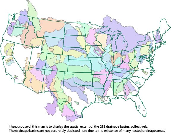
This dataset consists of drainage basin boundaries for 212 U.S. Geological Survey (USGS) stream sites sampled in the National Water-Quality Assessment (NAWQA) Program, the National Stream Quality Accounting Network (NASQAN), and the National Monitoring Network (NMN). Of the 212 sites, 206 have either a contributing or total drainage basin boundary, and the remaining 6 have both a total drainage basin boundary and a smaller contributing basin boundary. Collectively, these 218 basin boundaries have been used in a geographic information system (GIS) to generate basin characteristics for the assessment of trends in concentrations of pesticides streams of the United States.
This dataset describes site location information for samples collected within the western National Parks, USA, (Arches National Park (NP), Bryce Canyon NP, Canyonlands NP, Capitol Reef NP, Dinosaur National Monument (NM), Hovenweep NM, Timpanogos Cave NM, and Zion NP) for water chemistry analyses. Water-quality and bed-sediment samples were analyzed for contaminants of emerging concern at the National Water Quality Laboratory, Denver, Colorado, and Region 8 U.S. Environmental Protection Agency laboratory in Golden, Colorado. Additionally, quality assurance and quality control results are summarized.
This data release includes all pesticide results from selected batches of water samples analyzed by the U.S Geological Survey National Water Quality Laboratory (NWQL). Samples were analyzed using gas chromatography/mass spectrometry (GCMS) or liquid chromatography/mass spectrometry (LCMS) methods. Eight datasets are included in this data release; 1) all environmental and field quality control (QC) results for 11 pesticide compounds from 70 selected batches of GCMS data from schedules 2001, 2003, 2032, and 2033 (Sandstrom and others, 2001; Zaugg and others, 1995) from May 2001-June 2015, 2) all environmental and field QC results for 10 pesticide compounds from 43 selected batches of LCMS data from schedule 2060 (Furlong...
Categories: Data;
Types: Citation;
Tags: Blind blank,
Blind spike,
Censoring,
False negative,
False positive,
This data release documents water-quality data collected from April 2010 through December 2016 by the U.S. Geological Survey in cooperation with the San Antonio Water System from across the San Antonio segment of the Edwards aquifer with particular emphasis on nutrients and pesticides. Additional data regarding inorganic compounds and selected stable isotopes were obtained to provide a geochemical framework for characterizing source inputs and observed chemical changes during periods of hydrologic transition. Water-quality data were collected from surface-water and groundwater sites representing rural and urban land cover types. Data were obtained from unconfined wells in the recharge zone to characterize the rapid...
This data set contains the concentration results for water- and sediment-quality and tissue samples, as well as associated quality-assurance data, collected at sampling locations located in the Rocky Mountain National Park, Colorado. Samples were collected between 2012 and 2013. Samples were analyzed for nutrients, hormones, pharmaceutical, wastewater indicator compounds and pesticides, at the U.S. Geological Survey, National Water Quality Laboratory and the Organic Chemistry Research Laboratory, Sacramento, California. Bioassay analyses were performed at the National Fish Health Laboratory in Kearneysville, West Virginia. Data is also archived in the National Water Information System database (https://waterdata.usgs.gov/nwis).
Chemical and biological concentration results, quality assurance and quality control and statistical summaries from 26 tapwater samples, collected from paired residential and work place sites in 11 states in 2016. Samples were analylzed at U.S. Geological Survey and U.S. Environmental Protection Agency laboratories.
IMPORTANT NOTE: On February 6, 2016, it was discovered that duplicate pesticide use values were inadvertently included for site 07144100 "Little Arkansas River near Sedgwick, KS". In addition, users of the data requested that pesticide use estimates for glyphosate and glufosinate be included in the data release. The duplicate records were deleted and estimates for the two compounds were made in Version 2 of this data release. Two compound names, "cis-Permethrin" and "Paraoxon-ethyl", which were labelled incorrectly in this version, were changed to "Permethrin" and "Parathion" respectively in Version 2. The total count of pesticide compounds, including glyphosate and glufosinate, for which use is estimated is 116....
Categories: Data;
Tags: USGS Science Data Catalog (SDC),
United States,
Water Quality,
agriculture,
pesticides,
|

|
