Filters
Date Range
Types
Contacts
Tag Types
Tag Schemes
|

This EnviroAtlas web service supports research and online mapping activities related to EnviroAtlas (https://www.epa.gov/enviroatlas). The Clean and Plentiful Water category in this web service includes layers illustrating the ecosystems and natural resources that filter and regulate water, the need or demand for clean and plentiful water, the impacts associated with water quality, and factors that place stress on water quality and supply. EnviroAtlas allows the user to interact with a web-based, easy-to-use, mapping application to view and analyze multiple ecosystem services for the conterminous United States. Additional descriptive information about each attribute in this web service is located within each web...
Types: Citation;
Tags: 12-digit HUCs,
Agriculture,
Air,
Alabama,
Alaska, All tags...
Arizona,
Arkansas,
Austin, TX,
Biodiversity,
Biology,
Biophysical,
Biota,
Boundaries,
California,
Census Block Groups,
Cleanup,
Climate,
Colorado,
Communities,
Compliance,
Connecticut,
Conservation,
Contaminant,
Delaware,
Demand for Ecosystem Services,
Demographics,
Detroit, MI,
Disaster,
Drinking Water,
Drivers of Change - Ecosystem Services,
Durham, NC,
Ecology,
Economy,
Ecosystem,
Ecosystem,
Ecosystem Services,
Elevation,
Emergency,
Endangered,
Energy,
EnviroAtlas,
Environment,
Environment,
Environmental Atlas,
Environmental Justice,
Estuary,
Exposure,
Facilities,
Florida,
Food,
Fresno, CA,
Georgia,
Green Infrastructure,
Green Space,
Ground Water,
Habitat,
Hawaii,
Hazards,
Health,
Human,
Human Well-being,
Idaho,
Illinois,
Impact,
Imperiled,
Indiana,
Indicator,
Indoor Air,
Inspections,
Iowa,
Kansas,
Kentucky,
Land,
Land Cover,
Louisiana,
Maine,
Management,
Marine,
Maryland,
Massachusetts,
Michigan,
Milwaukee, WI,
Minnesota,
Mississippi,
Missouri,
Modeling,
Monitoring,
Montana,
Natural Resources,
Nebraska,
Nevada,
New Hampshire,
New Jersey,
New Mexico,
New York,
North Carolina,
North Dakota,
Ohio,
Oklahoma,
Oregon,
Pennsylvania,
Permits,
Pesticides,
Phoenix, AZ,
Portland, ME,
Portland, OR,
Potential for Change - Ecosystem Services,
Protected Lands,
Quality,
Radiation,
Recreation,
Regulatory,
Remediation,
Response,
Rhode Island,
Riparian,
Risk,
Sites,
Society,
Soils,
South Carolina,
South Dakota,
Spills,
Structure,
Supply of Ecosystem Services,
Surface Water,
Sustainability,
Tampa Bay, FL,
Tennessee,
Texas,
Threatened,
Toxics,
Transportation,
United States,
Utah,
Utilities,
Vermont,
Virginia,
Washington,
Washington DC,
Waste,
Water,
West Virginia,
Wetlands,
Wisconsin,
Wyoming,
environment, Fewer tags

This EnviroAtlas web service supports research and online mapping activities related to EnviroAtlas (https://www.epa.gov/enviroatlas). The Food, Fuel, and Materials category in this web service includes layers illustrating the ecosystems and natural resources that provide or support the production of food, fuel, or other materials, the need or demand for these items, the impacts associated with their presence and accessibility, and factors that place stress on the natural environment's capability to provide these benefits. EnviroAtlas allows the user to interact with a web-based, easy-to-use, mapping application to view and analyze multiple ecosystem services for the conterminous United States. Additional descriptive...
Types: Citation;
Tags: 12-digit HUCs,
Agriculture,
Air,
Alabama,
Alaska, All tags...
Arizona,
Arkansas,
Austin, TX,
Biodiversity,
Biology,
Biophysical,
Biota,
Boundaries,
California,
Census Block Groups,
Cleanup,
Climate,
Colorado,
Communities,
Compliance,
Connecticut,
Conservation,
Contaminant,
Delaware,
Demand for Ecosystem Services,
Demographics,
Detroit, MI,
Disaster,
Drinking Water,
Drivers of Change - Ecosystem Services,
Durham, NC,
Ecology,
Economy,
Ecosystem,
Ecosystem,
Ecosystem Services,
Elevation,
Emergency,
Endangered,
Energy,
EnviroAtlas,
Environment,
Environment,
Environmental Atlas,
Environmental Justice,
Estuary,
Exposure,
Facilities,
Florida,
Food,
Fresno, CA,
Georgia,
Green Infrastructure,
Green Space,
Ground Water,
Habitat,
Hawaii,
Hazards,
Health,
Human,
Human Well-being,
Idaho,
Illinois,
Impact,
Imperiled,
Indiana,
Indicator,
Indoor Air,
Inspections,
Iowa,
Kansas,
Kentucky,
Land,
Land Cover,
Louisiana,
Maine,
Management,
Marine,
Maryland,
Massachusetts,
Michigan,
Milwaukee, WI,
Minnesota,
Mississippi,
Missouri,
Modeling,
Monitoring,
Montana,
Natural Resources,
Nebraska,
Nevada,
New Hampshire,
New Jersey,
New Mexico,
New York,
North Carolina,
North Dakota,
Ohio,
Oklahoma,
Oregon,
Pennsylvania,
Permits,
Pesticides,
Phoenix, AZ,
Portland, ME,
Portland, OR,
Potential for Change - Ecosystem Services,
Protected Lands,
Quality,
Radiation,
Recreation,
Regulatory,
Remediation,
Response,
Rhode Island,
Riparian,
Risk,
Sites,
Society,
Soils,
South Carolina,
South Dakota,
Spills,
Structure,
Supply of Ecosystem Services,
Surface Water,
Sustainability,
Tampa Bay, FL,
Tennessee,
Texas,
Threatened,
Toxics,
Transportation,
United States,
Utah,
Utilities,
Vermont,
Virginia,
Washington,
Washington DC,
Waste,
Water,
West Virginia,
Wetlands,
Wisconsin,
Wyoming,
environment, Fewer tags
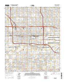
Layered GeoPDF 7.5 Minute Quadrangle Map. Layers of geospatial data include orthoimagery, roads, grids, geographic names, elevation contours, hydrography, and other selected map features.
Tags: 7.5 x 7.5 minute,
Arizona,
Downloadable Data,
EarthCover,
GeoPDF, All tags...
Imagery and Base Maps,
Map,
Maricopa,
Phoenix, AZ,
Public Land Survey System,
U.S. National Grid,
US,
US Topo,
US Topo Historical,
United States,
boundary,
contour,
geographic names,
hydrography,
imageryBaseMapsEarthCover,
orthoimage,
structures,
topographic,
transportation,
woodland, Fewer tags

This EnviroAtlas web service supports research and online mapping activities related to EnviroAtlas (https://www.epa.gov/enviroatlas). The Biodiversity Conservation category in this web service includes layers illustrating the ecosystems and natural resources that support biodiversity, the need or demand for conservation, the impacts associated with biodiversity and conservation, and factors that place stress on the natural environment's capability to maintain biodiversity. EnviroAtlas allows the user to interact with a web-based, easy-to-use, mapping application to view and analyze multiple ecosystem services for the conterminous United States. Additional descriptive information about each attribute in this web...
Types: Citation;
Tags: 12-digit HUCs,
Agriculture,
Air,
Alabama,
Alaska, All tags...
Arizona,
Arkansas,
Austin, TX,
Biodiversity,
Biology,
Biophysical,
Biota,
Boundaries,
California,
Census Block Groups,
Cleanup,
Climate,
Colorado,
Communities,
Compliance,
Connecticut,
Conservation,
Contaminant,
Delaware,
Demand for Ecosystem Services,
Demographics,
Detroit, MI,
Disaster,
Drinking Water,
Drivers of Change - Ecosystem Services,
Durham, NC,
Ecology,
Economy,
Ecosystem,
Ecosystem,
Ecosystem Services,
Elevation,
Emergency,
Endangered,
Energy,
EnviroAtlas,
Environment,
Environment,
Environmental Atlas,
Environmental Justice,
Estuary,
Exposure,
Facilities,
Florida,
Food,
Fresno, CA,
Georgia,
Green Infrastructure,
Green Space,
Ground Water,
Habitat,
Hawaii,
Hazards,
Health,
Human,
Human Well-being,
Idaho,
Illinois,
Impact,
Imperiled,
Indiana,
Indicator,
Indoor Air,
Inspections,
Iowa,
Kansas,
Kentucky,
Land,
Land Cover,
Louisiana,
Maine,
Management,
Marine,
Maryland,
Massachusetts,
Michigan,
Milwaukee, WI,
Minnesota,
Mississippi,
Missouri,
Modeling,
Monitoring,
Montana,
Natural Resources,
Nebraska,
Nevada,
New Hampshire,
New Jersey,
New Mexico,
New York,
North Carolina,
North Dakota,
Ohio,
Oklahoma,
Oregon,
Pennsylvania,
Permits,
Pesticides,
Phoenix, AZ,
Portland, ME,
Portland, OR,
Potential for Change - Ecosystem Services,
Protected Lands,
Quality,
Radiation,
Recreation,
Regulatory,
Remediation,
Response,
Rhode Island,
Riparian,
Risk,
Sites,
Society,
Soils,
South Carolina,
South Dakota,
Spills,
Structure,
Supply of Ecosystem Services,
Surface Water,
Sustainability,
Tampa Bay, FL,
Tennessee,
Texas,
Threatened,
Toxics,
Transportation,
United States,
Utah,
Utilities,
Vermont,
Virginia,
Washington,
Washington DC,
Waste,
Water,
West Virginia,
Wetlands,
Wisconsin,
Wyoming,
environment, Fewer tags
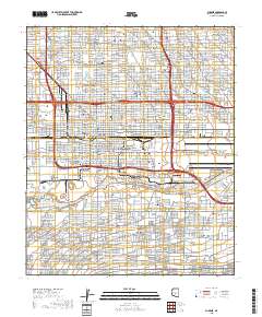
Layered geospatial PDF 7.5 Minute Quadrangle Map. Layers of geospatial data include orthoimagery, roads, grids, geographic names, elevation contours, hydrography, and other selected map features. This map is derived from GIS (geospatial information system) data. It represents a repackaging of GIS data in traditional map form, not creation of new information. The geospatial data in this map are from selected National Map data holdings and other government sources.
Tags: 7.5 x 7.5 minute,
Arizona,
Downloadable Data,
EarthCover,
Geospatial PDF, All tags...
Geospatial PDF,
Imagery and Base Maps,
Map,
Maricopa County,
Phoenix, AZ,
Public Land Survey System,
U.S. National Grid,
US,
US Topo,
US Topo Historical,
boundary,
contour,
geographic names,
hydrography,
imageryBaseMapsEarthCover,
orthoimage,
structures,
topographic,
transportation,
woodland, Fewer tags
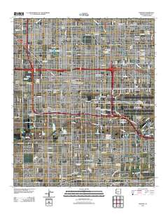
Layered GeoPDF 7.5 Minute Quadrangle Map. Layers of geospatial data include orthoimagery, roads, grids, geographic names, elevation contours, hydrography, and other selected map features.
Tags: 7.5 x 7.5 minute,
Arizona,
Downloadable Data,
EarthCover,
GeoPDF, All tags...
Imagery and Base Maps,
Map,
Maricopa,
Phoenix, AZ,
U.S. National Grid,
US,
US Topo,
US Topo Historical,
United States,
contour,
geographic names,
hydrography,
imageryBaseMapsEarthCover,
orthoimage,
structures,
topographic,
transportation, Fewer tags
|
|

