Filters: Tags: Phosphorus (X)
262 results (148ms)|
Filters
Date Range
Extensions Types Contacts
Categories Tag Types
|
These data were collected as part of a study headwater streams of the lowland Brazilian Amazon to assess the effects of land use change on organic matter dynamics (OM), ecosystem metabolism, and nutrient concentrations and uptake (nitrate and phosphate) in 11 first order streams draining forested (n=4) or cropland (n=7) water-sheds with intact riparian forests. Data included here are from 10 streams, were collected from 2015-2018, and are associated with the publication “Land use change influences ecosystem function of headwater streams of the lowland Amazon Basin”. The full dataset is comprised of five individual datasets: land cover and physical characteristics of all streams included in the study; monthly terrestrial...
This product provides tabular estimates of kilograms of nitrogen and phosphorus from a) fertilizer, and b) manure, for counties in the conterminous United States for the period 1950-2017. Data are generated for approximate five-year periods over the time, coinciding with U.S. Department of Agriculture Census of Agriculture census years. This data release also includes a model archive suitable for recreating the 2017 fertilizer estimates.
This dataset records Cladophora and associated benthic algae, collectively Cladophora community or submerged aquatic vegetation (SAV), biomass collected during the growing season of 2021 at stations located along the U.S. shoreline of Lakes Michigan, Huron, Erie, and Ontario. It also records a variety of supporting data collected at Cladophora measurement stations. These supporting data include: - seasonal time series of light, currents, wave action, temperature, specific conductivity, turbidity, pH, phycocyanin, chlorophyll, and dissolved oxygen from moored sensors at a subset of stations; - measurements of Secchi disk depth and water chemistry; - water column profiles of PAR, temperature, specific conductivity,...

These data were released prior to the October 1, 2016 effective date for the USGS’s policy dictating the review, approval, and release of scientific data as referenced in USGS Survey Manual Chapter 502.8 Fundamental Science Practices: Review and Approval of Scientific Data for Release. This spatial data set was created by the U.S. Geological Survey (USGS) to represent the amount of phosphorus generated by pastured, non-cattle livestock that was applied to pasture land in the Pacific Northwest region of the United States (Hydro Region 17; Major River Basin 7 (MRB7)) during 2002.
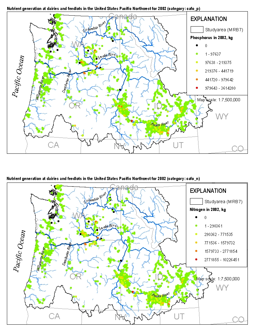
This spatial data set was created by the U.S. Geological Survey (USGS) to represent the amount of nitrogen and phosphorus generated by cattle at dairies and feedlots in the Pacific Northwest region of the United States (Hydro Region 17; Major River Basin 7 (MRB7)) during 2002.
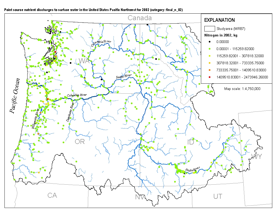
This spatial data set was created by the U.S. Geological Survey (USGS) to represent the amount of total nitrogen and total phosphorus discharged to surface waters in the Pacific Northwest region of the United States (Hydro Region 17; Major River Basin 7 (MRB7)) during 2002 from individual permitted wastewater facilities.
Nitrogen, phosphorus, and suspended-sediment loads, and changes in loads, in major rivers across the Chesapeake Bay watershed have been calculated using monitoring data from the Chesapeake Bay River Input Monitoring (RIM) Network stations for the period 1985 through 2022. Nutrient and suspended-sediment loads and changes in loads were determined by applying a weighted regression approach called WRTDS (Weighted Regression on Time, Discharge, and Season). The load results represent the total mass of nitrogen, phosphorus, and suspended sediment that was exported from each of the RIM watersheds.
Categories: Data;
Types: Map Service,
OGC WFS Layer,
OGC WMS Layer,
OGC WMS Service;
Tags: Chesapeake Bay Watershed,
Delaware,
Kalman filtering,
Maryland,
New York,
The U.S. Geological Survey (USGS) has compiled a geodatabase containing mineral-related geospatial data for the People's Republic of China. The data can be used in analyses of the extractive fuel and nonfuel mineral industries and related economic and physical infrastructure integral for the successful operation of the mineral industries within the area of study as well as the movement of mineral products across domestic and global markets. This geodatabase reflects the USGS ongoing commitment to its mission of understanding the nature and distribution of global mineral commodity supply chains by updating and publishing the georeferenced locations of mineral commodity production and processing facilities, mineral...
Nitrogen, phosphorus, and suspended-sediment loads, and changes in loads, in major rivers across the Chesapeake Bay watershed have been calculated using monitoring data from the Chesapeake Bay River Input Monitoring Network (RIM) stations for the period 1985 through 2019. Nutrient and suspended-sediment loads and changes in loads were determined by applying a weighted regression approach called WRTDS (Weighted Regression on Time, Discharge, and Season). The load results represent the total mass of nitrogen, phosphorus, and suspended sediment that was exported from each of the RIM watersheds.
Categories: Data;
Types: Map Service,
OGC WFS Layer,
OGC WMS Layer,
OGC WMS Service;
Tags: Chesapeake Bay Watershed,
Delaware,
Maryland,
New York,
Pennsylvania,
Nitrogen, phosphorus, and suspended-sediment loads, and changes in loads, in major rivers across the Chesapeake Bay watershed have been calculated using monitoring data from the Chesapeake Bay River Input Monitoring Network (RIM) stations for the period 1985 through 2017. Nutrient and suspended-sediment loads and changes in loads were determined by applying a weighted regression approach called WRTDS (Weighted Regression on Time, Discharge, and Season). Yields (represents the mass of constituent transported from a unit area of a given watershed) are used to compare the export loads from one basin to another. Yield results are obtained by dividing the annual load (pounds) of a given constituent by the respective...
Categories: Data;
Types: Map Service,
OGC WFS Layer,
OGC WMS Layer,
OGC WMS Service;
Tags: Chesapeake Bay Watershed,
Delaware,
Maryland,
New York,
Pennsylvania,
Effects of annual additions of mineral N and P (100 kg ha-1) on plant species composition and annual aboveground net primary production (ANPP) were investigated during the first three years following disturbance in a semi-arid ecosystem. Additions of N reduced richness of perennial plant species during years 2 and 3, while P reduced the number of perennial species only in year 3. From year 1 to year 2, annual and biennial species richness declined in all treatments while ANPP of annual species increased greatly. Added N increased ANPP of annual species while it decreased ANPP of most perennial species relative to the unfertilized control treatment. Community similarities were higher for the control and native vegetation...
Categories: Publication;
Types: Citation,
Journal Citation;
Tags: Plant and Soil,
Springer Netherlands,
disturbance,
fertilizer,
nitrogen,
In drylands of southeastern Utah, USA, the invasive exotic grass Bromus tectorum L. occurs in distinct spatial patterns suggesting soil control of ecosystem susceptibility to invasion. To improve our understanding of these patterns, we examined performance of B. tectorum in relation to additions of water, KCl, MgO, and CaO at seventeen 1600 m2 sites distributed across a calcareous soil gradient in Canyonlands National Park. Water additions resulted in a 57% increase in B. tectorum establishment. Fall establishment was significantly correlated with silt and clay content in wet plots but not in dry plots, suggesting that texture effects on B. tectorum establishment patterns may be greater in wet years than in dry...
Categories: Publication;
Types: Citation,
Journal Citation;
Tags: Plant and Soil,
invasive species,
magnesium,
manganese,
phosphorus,
A comprehensive study to evaluate water-quality trends in the international Red River of the North basin and to assess water-quality conditions for Red River of the North crossing the international boundary near Emerson, Manitoba was completed by the U.S. Geological Survey (USGS) in cooperation with the International Joint Commission, North Dakota Department of Environmental Quality (NDDEQ) and Minnesota Pollution Control Agency (MPCA), and in collaboration with Manitoba Sustainable Development (MSD) and Environment and Climate Change Canada (ECCC). In this dataset a zipped folder is provided which contains all files necessary to run models and produce results published in U.S. Geological Scientific Investigations...
This data release consists of the data used to develop SPAtially Referenced Regression On Watershed(SPARROW) attributes models for estimating loads of total phosphorus and total nitrogen in Tennessee streams. These data support the publication containing the Tennessee SPARROW models results (Hoos and others, 2019) and include model input used in the South Atlantic-Gulf Drainages and Tennessee River Basin (SAGT) nutrient SPARROW models (Hoos and McMahon, 2009; Garcia and others, 2011) as well as model input for river basins in Tennessee not included in the domain of the published SAGT SPARROW models. Also included in this data release are model coefficients, the software required to execute the Tennessee SPARROW...
This data release consists of the data used to develop SPAtially Referenced Regression On Watershed(SPARROW) attributes models for estimating loads of total phosphorus and total nitrogen in Tennessee streams. These data support the publication containing the Tennessee SPARROW models results (Hoos and others, 2019) and include model input used in the South Atlantic-Gulf Drainages and Tennessee River Basin (SAGT) nutrient SPARROW models (Hoos and McMahon, 2009; Garcia and others, 2011) as well as model input for river basins in Tennessee not included in the domain of the published SAGT SPARROW models. Also included in this data release are model coefficients, the software required to execute the Tennessee SPARROW...
Nitrogen, phosphorus, and suspended-sediment loads, and changes in loads, in major rivers across the Chesapeake Bay watershed have been calculated using monitoring data from the Chesapeake Bay River Input Monitoring Network (RIM) stations for the period 1985 through 2018. Nutrient and suspended-sediment loads and changes in loads were determined by applying a weighted regression approach called WRTDS (Weighted Regression on Time, Discharge, and Season). Yields (represents the mass of constituent transported from a unit area of a given watershed) are used to compare the export loads from one basin to another. Yield results are obtained by dividing the annual load (pounds) of a given constituent by the respective...
Categories: Data;
Types: Map Service,
OGC WFS Layer,
OGC WMS Layer,
OGC WMS Service;
Tags: Chesapeake Bay Watershed,
Delaware,
Maryland,
New York,
Pennsylvania,
Nitrogen, phosphorus, and suspended-sediment loads, and changes in loads, in major rivers across the Chesapeake Bay watershed have been calculated using monitoring data from the Chesapeake Bay River Input Monitoring Network (RIM) stations for the period 1985 through 2019. Nutrient and suspended-sediment loads and changes in loads were determined by applying a weighted regression approach called WRTDS (Weighted Regression on Time, Discharge, and Season). The load results represent the total mass of nitrogen, phosphorus, and suspended sediment that was exported from each of the RIM watersheds.
Categories: Data;
Types: Map Service,
OGC WFS Layer,
OGC WMS Layer,
OGC WMS Service;
Tags: Chesapeake Bay Watershed,
Delaware,
Maryland,
New York,
Pennsylvania,
The U.S. Geological Survey (USGS) has undertaken a mineral resources assessment for tungsten for a portion of the Great Basin in parts of western Nevada and east-central California. This data release provides the Great Basin Tungsten Database: the geospatial and geologic data, and results of chemical analyses for 46,955 samples collected in the assessment area, extracted from the USGS National Geochemical Database. These rock records were collected as part of various programs and projects at the USGS and analyzed from 1963 to 2015. The database represents rock records, each comprising one best value chemical determination for each analyzed chemical species, that include skarns, carbonate lithologies (for example,...
Categories: Data;
Types: Downloadable,
Map Service,
OGC WFS Layer,
OGC WMS Layer,
Shapefile;
Tags: California,
GGGSC,
Geology, Geophysics, and Geochemistry Science Center,
Great Basin,
MRP,
Yes, all data values are reasonable and within the valid range for measurement. The data release consists of 15 tabular data files (csv). These data were compiled to compare patterns and potential drivers of leaf litter decomposition in the Colorado River downstream of Glen Canyon Dam between 1998 and 2022. Objective(s) of our study were to compare the breakdown of cottonwood (Populus fremontii), willow (Salix exigua), and salt cedar (Tamarix chinensis) leaves to a previous decomposition experiment from 1998 (Pomeroy et al. 2000) that was conducted in the context of much cooler water temperatures, higher phosphorus concentrations, lower New Zealand mudsnail densities, and salt cedar litter that was unaffected by...
Nitrogen, phosphorus, and suspended-sediment loads, and changes in loads, in rivers across the Chesapeake Bay watershed have been calculated using monitoring data from the Chesapeake Bay Nontidal Network (NTN) stations for the period 1985 through 2014. Nutrient and suspended-sediment loads and changes in loads were determined by applying a weighted regression approach called WRTDS (Weighted Regression on Time, Discharge, and Season). The load results represent the total mass of nitrogen, phosphorus, and suspended sediment that was exported from each of the NTN watersheds. To determine the trend in loads, the annual load results are flow normalized to integrate out the year-to-year variability in river discharge....
Categories: Data;
Types: Citation,
Map Service,
OGC WFS Layer,
OGC WMS Layer,
OGC WMS Service;
Tags: Chesapeake Bay Watershed,
USGS Science Data Catalog (SDC),
Water Quality,
load analysis,
nitrogen,
|

|
