Filters: Tags: Puget Sound (X) > partyWithName: U.S. Geological Survey (X)
20 results (46ms)|
Filters
Date Range
Extensions Types Contacts
Categories
Tag Types Tag Schemes |
Note: This dataset has been revised and superseded by version 2.0, available here: https://doi.org/10.5066/P90PG34S. Remote sensing based maps of tidal marshes, both of their extents and carbon stocks, have the potential to play a key role in conducting greenhouse gas inventories and implementing climate mitigation policies. Our objective was to generate a single remote sensing model of tidal marsh aboveground biomass and carbon that represents nationally diverse tidal marshes within the conterminous United States (CONUS). To meet this objective we developed the first national-scale dataset of aboveground tidal marsh biomass, species composition, and aboveground plant carbon content (%C) from six CONUS regions:...

These data were released prior to the October 1, 2016 effective date for the USGS’s policy dictating the review, approval, and release of scientific data as referenced in USGS Survey Manual Chapter 502.8 Fundamental Science Practices: Review and Approval of Scientific Data for Release. Septic systems are useful for removing and processing human waste. However, they have the potential of leaking or discharging waste into the nearby system and increasing potential contamination of nearby streams. Data represent potential locations of septic sewers in the Pacific Northwest based on extrapolation of 1990 Census tract block group level information.
OBIS-USA brings together marine biological occurrence data – recorded observations of identifiable marine species at a known time and place, collected primarily from U.S. Waters or with U.S. funding. Coordinated by the Science Analytics and Synthesis (SAS) Program of the United States Geological Survey (USGS), OBIS-USA, strives to meet national data integration and dissemination needs for marine data about organisms and ecosystems. OBIS-USA is part of an international data sharing network (Ocean Biodiversity Information System, OBIS) coordinated by the Intergovernmental Oceanographic Commission, of UNESCO (United Nations Educational, Science and Cultural Organization) International Oceanographic Data and Information...
A hydrologic monitoring network was installed to investigate landslide hazards affecting the railway corridor along the eastern shore of Puget Sound between Seattle and Everett, near Mukilteo, Washington. During the summer of 2015, the U.S. Geological Survey installed instrumentation at four sites to measure rainfall and air temperature every 15 minutes. Two of the four sites are installed on contrasting coastal bluffs, one landslide scarred and one vegetated. At these two sites, in addition to rainfall and air temperature, volumetric water content, pore pressure, soil suction, soil temperature (via hydrologic instrumentation), and barometric pressure were measured every 15 minutes. The instrumentation was designed...
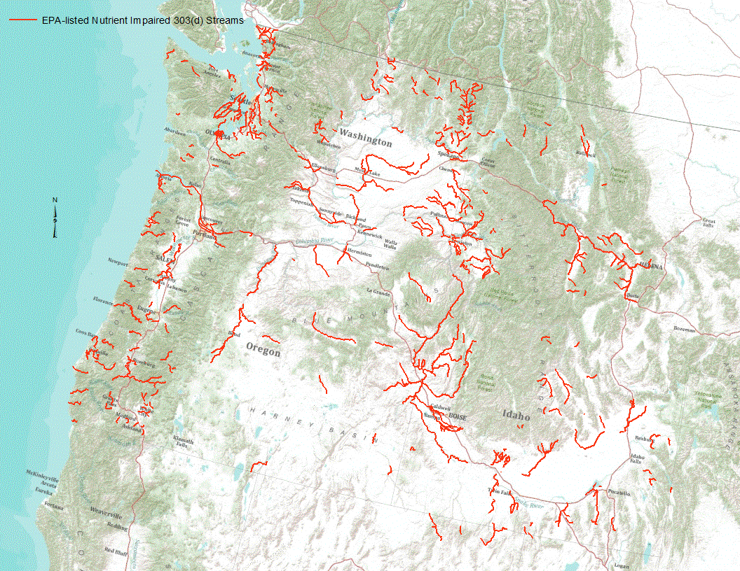
“Under section 303(d) of the 1972 Clean Water Act, states, territories, and authorized tribes are required to develop lists of impaired waters. These impaired waters do not meet water quality standards that states, territories, and authorized tribes have set for them, even after point sources of pollution have installed the minimum required levels of pollution control technology. The law requires that these jurisdictions establish priority rankings for waters on the lists and develop TMDLs for these waters” (U.S. Environmental Protection Agency, 2011). Waterways represented in this data set are a subset of these EPA 303 (d) listed streams that were classified as nutrient impaired. Nutrient impaired streams include...
Remote sensing based maps of tidal marshes, both of their extents and carbon stocks, have the potential to play a key role in conducting greenhouse gas inventories and implementing climate mitigation policies. Our objective was to generate a single remote sensing model of tidal marsh aboveground biomass and carbon that represents nationally diverse tidal marshes within the conterminous United States (CONUS). To meet this objective we developed the first national-scale dataset of aboveground tidal marsh biomass, species composition, and aboveground plant carbon content (%C) from six CONUS regions: Cape Cod, MA, Chesapeake Bay, MD, Everglades, FL, Mississippi Delta, LA, San Francisco Bay, CA, and Puget Sound, WA....
Categories: Data;
Tags: C-band synthetic aperture radar,
Cape Cod,
Chesapeake Bay,
National greenhouse gas inventory,
Puget Sound,
This archive contains the input data for the conceptual well locations for the logistic mapping. Data were computed for either the well location or within a buffer area of the well location, as specified in the parameter definition.
This archive contains the logistic mapping output vulnerability difference rasters at the conceptual well locations. Data are provided in rasters containing the differences between estimated probabilities of nitrate concentrations greater than 2 milligrams per liter at hypothetical 150 feet and 300 feet deep wells for sequential five-year categories when one or both of the predicted probabilities was equal to or greater than 50 percent.
Categories: Data;
Types: Downloadable,
GeoTIFF,
Map Service,
Raster;
Tags: Drinking Water,
Groundwater,
Puget Sound,
Washington,
Wells,

These data were released prior to the October 1, 2016 effective date for the USGS’s policy dictating the review, approval, and release of scientific data as referenced in USGS Survey Manual Chapter 502.8 Fundamental Science Practices: Review and Approval of Scientific Data for Release. Under section 303(d) of the 1972 Clean Water Act, states, territories, and authorized tribes are required to develop lists of impaired waters. These impaired waters do not meet water quality standards that states, territories, and authorized tribes have set for them, even after point sources of pollution have installed the minimum required levels of pollution control technology. The law requires that these jurisdictions establish...
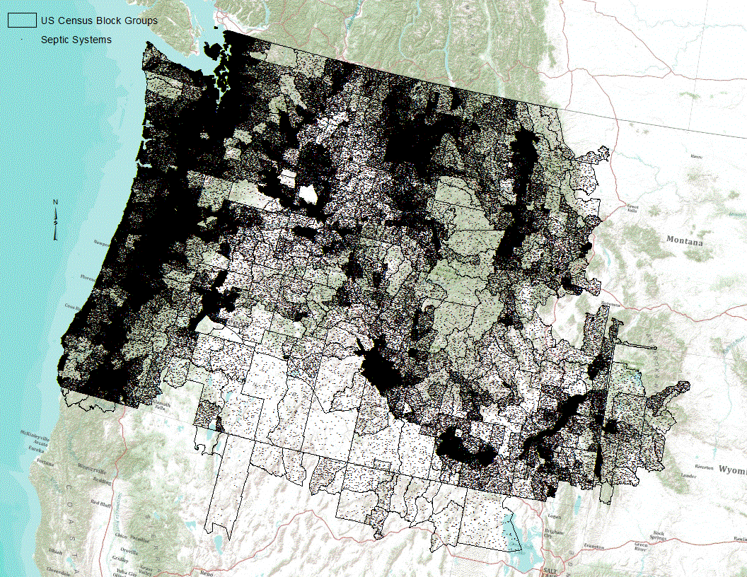
Septic systems are useful for removing and processing human waste. However, they have the potential of leaking or discharging waste into the nearby system and increasing potential contamination of nearby streams. Data represent potential locations of septic sewers in the Pacific Northwest based on extrapolation of 1990 Census tract block group level information.
This archive contains shapefiles of the grid of conceptual well locations and study area.
Categories: Data;
Types: Downloadable,
Map Service,
OGC WFS Layer,
OGC WMS Layer,
Shapefile;
Tags: Drinking Water,
Groundwater,
Puget Sound,
Washington,
Wells,

These data were released prior to the October 1, 2016 effective date for the USGS’s policy dictating the review, approval, and release of scientific data as referenced in USGS Survey Manual Chapter 502.8 Fundamental Science Practices: Review and Approval of Scientific Data for Release. Phosphorus is a naturally occurring element found in all rocks; the amount varies by the type of rock. The amount of phosphorus in sediments is expected to be correlated with the amount of phosphorus in the parent rocks. Streambed sediment collected by the National Uranium Resource Evaluation (NURE) Program were used to estimate the variation of phosphorus across the Pacific Northwest. This file provides an estimate of the mean concentration...
First Release: Aug 2017 Revised: May 2018 (ver. 1.1) Time-series data of velocity, pressure, turbidity, conductivity, and temperature were collected near the mouth of the Elwha River, Washington, USA, from December 2010 through October 2014, for the Department of Interior’s Elwha River Restoration project. As part of this project, the U.S. Geological Survey studied the effects of renewed sediment supplies on the coastal ecosystems before, during, and following the removal of two dams, Elwha and Glines Canyon, from the Elwha River. Removal of the dams reintroduced sediment stored in the reservoirs to the river, and the river moved much of this sediment to the coast. Several benthic tripods were instrumented with...
Categories: Data,
Data Release - Revised;
Types: Citation;
Tags: CMGP,
CONDUCTIVITY,
CTD,
CTD measurement,
CURRENT METERS,
OBIS-USA brings together marine biological occurrence data – recorded observations of identifiable marine species at a known time and place, collected primarily from U.S. Waters or with U.S. funding. Coordinated by the Core Science, Analytics, Synthesis, and Libraries (CSAS&L) Program of the United States Geological Survey (USGS), OBIS-USA, strives to meet national data integration and dissemination needs for marine data about organisms and ecosystems. OBIS-USA is part of an international data sharing network (Ocean Biogeographic Information System, OBIS) coordinated by the Intergovernmental Oceanographic Commission, of UNESCO (United Nations Educational, Science and Cultural Organization International Oceanographic...
Categories: Project;
Types: NSDI Cooperative Agreements Program Project;
Tags: Arctic Ocean,
Atlantic Ocean,
Bay of Fundy,
Beaufort Sea,
Bering Sea,
This archive contains the logistic mapping output data at the conceptual well locations. Data are provided in spreadsheets containing the estimated probabilities of nitrate concentrations greater than 2 milligrams per liter at hypothetical 150 feet and 300 feet deep wells for each of the five-year categories from 2000 to 2019 and vulnerability differences between five-year categories when one or both of the predicted probabilities was equal to or greater than 50 percent.
Remote sensing based maps of tidal marshes, both of their extents and carbon stocks, have the potential to play a key role in conducting greenhouse gas inventories and implementing climate mitigation policies. Our objective was to generate a single remote sensing model of tidal marsh aboveground biomass and carbon that represents nationally diverse tidal marshes within the conterminous United States (CONUS). To meet this objective we developed the first national-scale dataset of aboveground tidal marsh biomass, species composition, and aboveground plant carbon content (%C) from six CONUS regions: Cape Cod, MA, Chesapeake Bay, MD, Everglades, FL, Mississippi Delta, LA, San Francisco Bay, CA, and Puget Sound, WA....
Categories: Data;
Tags: C-band synthetic aperture radar,
Cape Cod,
Carbon sequestration,
Chesapeake Bay,
Everglades National Park,
This archive contains the logistic mapping vulnerability output rasters at the conceptual well locations. Data are provided in rasters containing the estimated probabilities of nitrate concentrations greater than 2 milligrams per liter at hypothetical 150-foot-deep and 300-foot-deep wells.
Categories: Data;
Types: Downloadable,
GeoTIFF,
Map Service,
OGC WFS Layer,
OGC WMS Layer,
Raster,
Shapefile;
Tags: Drinking Water,
Groundwater,
Puget Sound,
Washington,
Wells,
Landforms along the Pacific, Gulf of Mexico, and Atlantic coastlines for the conterminous United States are attributed with the relative vulnerability of horizontal erosion due to sea-level rise to characterize coastal zone stability. The position and extent of landforms are geospatially indexed as line-events where these coastal zone features are intersected by the linear-referenced 2013 - 2014 U.S. Geological Survey National Hydrography Dataset Coastline, which corresponds to the National Oceanic and Atmospheric Administration (NOAA) 2013 - 2014 mean high water level datum delineated in intertidal zones open to oceans, behind barrier coasts in bays, lagoons, and estuaries, and sometimes where tidal currents reach...

These data were released prior to the October 1, 2016 effective date for the USGS’s policy dictating the review, approval, and release of scientific data as referenced in USGS Survey Manual Chapter 502.8 Fundamental Science Practices: Review and Approval of Scientific Data for Release. Red alder (Alnus rubra) are a common component of forests in Western Oregon and Washington. This file provides an estimate of red alder basal area in western Oregon and Washington for each incremental catchment of the USGS Pacific Northwest SPARROW model.
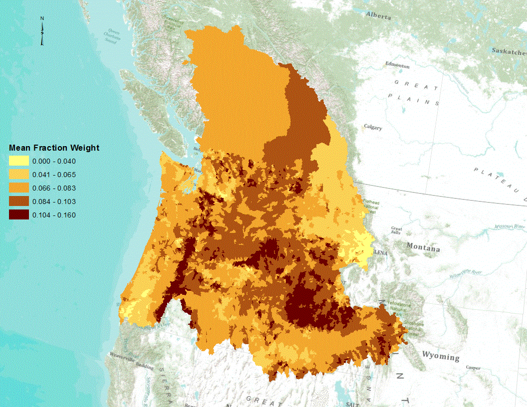
Phosphorus is a naturally occurring element found in all rocks; the amount varies by the type of rock. The amount of phosphorus in sediments is expected to be correlated with the amount of phosphorus in the parent rocks. Streambed sediment collected by the National Uranium Resource Evaluation (NURE) Program were used to estimate the variation of phosphorus across the Pacific Northwest. This file provides an estimate of the mean concentration of phosphorus in soils for each incremental catchment of the USGS Pacific Northwest SPARROW model.
|

|
