Filters: Tags: Puget Sound (X)
78 results (10ms)|
Filters
Date Range
Extensions (Less)
Types (Less)
Contacts (Less)
Categories (Less)
Tag Types
|
Investigations of coastal change and coastal resources often require continuous elevation profiles from the seafloor to coastal terrestrial landscapes. Differences in elevation data collection in the terrestrial and marine environments result in separate elevation products that may not share a vertical datum. This data release contains the assimilation of multiple elevation products into a continuous digital elevation model at a resolution of 3-arcseconds (approximately 90 meters) from the terrestrial landscape to the seafloor for the contiguous U.S., focused on the coastal interface. All datasets were converted to a consistent horizontal datum, the North American Datum of 1983, but the native vertical datum for...
Types: Map Service,
OGC WFS Layer,
OGC WMS Layer,
OGC WMS Service;
Tags: Alabama,
CMGP,
California,
Canadian Hydrographic Service,
Chesapeake Bay,
Note: This dataset has been revised and superseded by version 2.0, available here: https://doi.org/10.5066/P90PG34S. Remote sensing based maps of tidal marshes, both of their extents and carbon stocks, have the potential to play a key role in conducting greenhouse gas inventories and implementing climate mitigation policies. Our objective was to generate a single remote sensing model of tidal marsh aboveground biomass and carbon that represents nationally diverse tidal marshes within the conterminous United States (CONUS). To meet this objective we developed the first national-scale dataset of aboveground tidal marsh biomass, species composition, and aboveground plant carbon content (%C) from six CONUS regions:...
Throughout a 20-year biosurveillance period, viral hemorrhagic septicemia virus was isolated in low titers from only 6 / 7,355 opportunistically sampled adult Pacific herring, reflecting the typical endemic phase of the disease when the virus persists covertly. However, more focused surveillance efforts identified the presence of disease hot spots occurring among juvenile life history stages from certain nearshore habitats. These outbreaks sometimes recurred annually in the same temporal and spatial patterns and were characterized by infection prevalence as high as 96%. Longitudinal sampling indicated that some epizootics were relatively transient, represented by positive samples on a single sampling date, and others...

These data were released prior to the October 1, 2016 effective date for the USGS’s policy dictating the review, approval, and release of scientific data as referenced in USGS Survey Manual Chapter 502.8 Fundamental Science Practices: Review and Approval of Scientific Data for Release. Septic systems are useful for removing and processing human waste. However, they have the potential of leaking or discharging waste into the nearby system and increasing potential contamination of nearby streams. Data represent potential locations of septic sewers in the Pacific Northwest based on extrapolation of 1990 Census tract block group level information.
This part of the data release provides the U.S. Geological Survey (USGS), Pacific Coastal and Marine Science Center (PCMSC) 2007 bathymetry data collected in Skagit Bay Washington that is provided as a 1-m resolution TIFF image, as well as a 1-m resolution shaded-relief TIFF image. FGDC metadata is also provided. In 2004, 2005, 2007, and 2010 the USGS, PCMSC collected bathymetry and acoustic backscatter data in Skagit Bay, Washington using an interferometric bathymetric sidescan-sonar system mounded to the USGS R/V Parke Snavely and the USGS R/V Karluk. The research was conducted in coordination with the Swinomish Indian Tribal Community, Skagit River System Cooperative, Skagit Watershed Council, Puget Sound Nearshore...
Categories: Data;
Types: Citation;
Tags: Bathymetry,
Bathymetry,
Bathymetry and Elevation,
CMGP,
Coastal and Marine Geology Program,
This portion of the data release presents a high-resolution orthomosaic images of the intertidal zone at Post Point, Bellingham Bay, WA. The orthomosaics were derived from structure-from-motion (SfM) processing of aerial imagery collected with an unmanned aerial system (UAS) on 2019-06-06. The orthomosaics are presented with two resolutions: one image, covering the entire survey area, has a resolution of 2 centimeters per pixel; the other image which was derived from a lower-altitude flight, covers an inset area within the main survey area and has a resolution of 1 centimeter per pixel. The raw imagery used to create the orthomosaics was acquired using a UAS fitted with a Ricoh GR II digital camera featuring a global...
A three-dimensional groundwater flow model was developed in 1997 to evaluate the groundwater flow system at Puget Sound Naval Shipyard, Naval Base Kitsap, Bremerton, Washington (https://pubs.er.usgs.gov/publication/wri964147). In 2016, a regional groundwater flow model for the greater Kitsap Peninsula was developed (https://pubs.er.usgs.gov/publication/sir20165052). Using information from the 2016 regional model, the 1997 groundwater flow model for the Puget Sound Naval Shipyard was updated with a new interpretation of the underlying hydrogeologic units, a refined model grid, and improved recharge estimates. A steady-state model version was constructed in MODFLOW-NWT to simulate equilibrium conditions. MODPATH forward...
OBIS-USA brings together marine biological occurrence data – recorded observations of identifiable marine species at a known time and place, collected primarily from U.S. Waters or with U.S. funding. Coordinated by the Science Analytics and Synthesis (SAS) Program of the United States Geological Survey (USGS), OBIS-USA, strives to meet national data integration and dissemination needs for marine data about organisms and ecosystems. OBIS-USA is part of an international data sharing network (Ocean Biodiversity Information System, OBIS) coordinated by the Intergovernmental Oceanographic Commission, of UNESCO (United Nations Educational, Science and Cultural Organization) International Oceanographic Data and Information...
A three-dimensional groundwater flow model, constructed in MODFLOW-NWT, was developed to evaluate the groundwater flow system near Puget Sound, Pierce and King Counties, Washington. A steady-state model version was constructed to simulate equilibrium conditions, while a transient model version was constructed to simulate monthly variability from January 2005 to December 2015. The model was used to simulate several hydrologic scenarios. This data release contains the input and output files for the simulations described in the associated model documentation report (https://doi.org/10.3133/sir20XXXXXX).
A time-lapse camera was used to document periodic reactivation of a complex landslide on a steep coastal bluff in Mukilteo, Washington. This landslide is one of four monitoring sites initiated by the U.S Geological Survey to investigate hill-slope hydrology and landslide hazards affecting the railway corridor along the eastern shore of Puget Sound between the cities of Seattle and Everett (Mirus et al., 2016; Smith et al. 2017). The camera was installed in the crown of the landslide above the main scarp facing roughly North, with a field of view that includes the head of the landslide body and a minor scarp below. The attached file ‘CameraLocation.PNG’ provides an overview figure of the landslide and the camera’s...
A hydrologic monitoring network was installed to investigate landslide hazards affecting the railway corridor along the eastern shore of Puget Sound between Seattle and Everett, near Mukilteo, Washington. During the summer of 2015, the U.S. Geological Survey installed instrumentation at four sites to measure rainfall and air temperature every 15 minutes. Two of the four sites are installed on contrasting coastal bluffs, one landslide scarred and one vegetated. At these two sites, in addition to rainfall and air temperature, volumetric water content, pore pressure, soil suction, soil temperature (via hydrologic instrumentation), and barometric pressure were measured every 15 minutes. The instrumentation was designed...
Stormwater Action Monitoring (SAM) is a collaborative monitoring program between western Washington municipal stormwater permittees, state and federal agencies. SAM’s role is to use the results of regional monitoring and focused studies to inform policy decisions and identify effective strategies to improve stormwater management in the Puget Sound region. The SAM program includes status and trends monitoring of water quality, stream biota (macroinvertebrates, algae), and stream habitat to measure whether conditions are getting better or worse and identify patterns in healthy and impaired Puget Lowland streams. To meet this objective, a framework of fundamental geospatial data was required to develop physical and...
Project Summary Climate change is projected to have substantial impacts on Pacific Northwest water resources and ecosystems. Recognizing this, resource managers have expressed growing interest in incorporating climate change information into long-range planning. The availability of hydrologic scenarios to support climate change adaptation and long-range planning, however, has been limited until very recently to a relatively small number of selected case studies. More comprehensive resources needed to support regional planning have been lacking. Furthermore, ecosystem studies at the landscape scale need consistent climate change information and databases over large geographic areas. Products using a common set of...
SLAMM-View is a web browser-based application that provides tools for improved understanding of results from research projects that employ the Sea Level Affecting Marshes Model (SLAMM). Version 2.0 of SLAMM-View was designed for a user-friendly, workflow-based approach to assess impacts of sea-level rise (SLR) on coastal areas with both visualization and analysis functionality. SLAMM-View provides simultaneous comparison between both current and future conditions out to the year 2100, and among different SLR scenarios (e.g., 0.4 meter vs. 1 meter), using interactive maps and tabular reporting capabilities. To date, SLAMM-View provides access to SLAMM simulation results for the entire coastlines of 5 states, and...
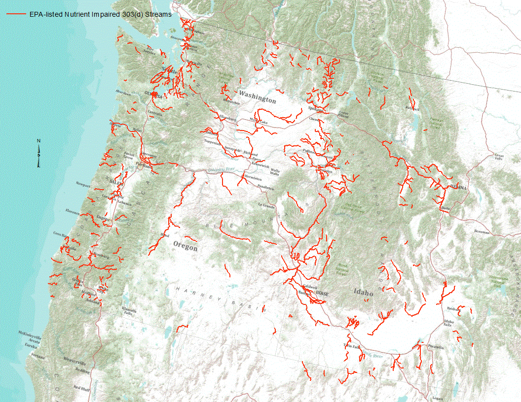
“Under section 303(d) of the 1972 Clean Water Act, states, territories, and authorized tribes are required to develop lists of impaired waters. These impaired waters do not meet water quality standards that states, territories, and authorized tribes have set for them, even after point sources of pollution have installed the minimum required levels of pollution control technology. The law requires that these jurisdictions establish priority rankings for waters on the lists and develop TMDLs for these waters” (U.S. Environmental Protection Agency, 2011). Waterways represented in this data set are a subset of these EPA 303 (d) listed streams that were classified as nutrient impaired. Nutrient impaired streams include...
This part of the data release provides the U.S. Geological Survey (USGS), Pacific Coastal and Marine Science Center (PCMSC) 2005 bathymetry data collected in Skagit Bay Washington that is provided as a 1-m resolution TIFF image, as well as a 1-m resolution shaded-relief TIFF image. FGDC metadata is also provided. In 2004, 2005, 2007, and 2010 the USGS, PCMSC collected bathymetry and acoustic backscatter data in Skagit Bay, Washington using an interferometric bathymetric sidescan-sonar system mounded to the USGS R/V Parke Snavely and the USGS R/V Karluk. The research was conducted in coordination with the Swinomish Indian Tribal Community, Skagit River System Cooperative, Skagit Watershed Council, Puget Sound Nearshore...
Categories: Data;
Types: Citation;
Tags: Bathymetry,
Bathymetry,
Bathymetry and Elevation,
CMGP,
Coastal and Marine Geology Program,
There is a fundamental knowledge gap on the distribution, prevalence, intensity, and ecology of salmonid myxozoan parasites in the Lake Sammamish watershed, Washington. To address this knowledge gap, we tested water samples for Ceratonova shasta, Parvicapsula minibicornis and Tetracapsuloides bryosalmonae DNA from 84 sites distributed throughout the Lake Sammamish watershed in fall 2019 and 74 sites in spring 2020. Our surveillance identified zones with high waterborne parasite loads and provides a proof of concept for this approach that could be expanded throughout the larger Lake Washington watershed.
Categories: Data;
Tags: Aquatic Biology,
Ceratonova shasta,
Ecology,
Parvicapsula minibicornis,
Puget Sound,
This portion of the data release presents digital surface models (DSMs) and hillshade images of the intertidal zone at Post Point, Bellingham Bay, WA. The DSMs were derived from structure-from-motion (SfM) processing of aerial imagery collected with an unmanned aerial system (UAS) on 2019-06-06. Unlike a digital elevation model (DEM), the DSMs represent the elevation of the highest object within the bounds of a cell. Vegetation, buildings and other objects have not been removed from the data. In addition, data artifacts resulting from noise in the original imagery have not been removed. The DSMs are presented with two resolutions: one DSM, covering the entire survey area, has a resolution of 4 centimeters per pixel;...
This portion of the data release presents the locations of the temporary ground control points (GCPs) used for the structure-from-motion (SfM) processing of the imagery collected during an unmanned aerial system (UAS) survey of the intertidal zones at Puget Creek and Dickman Mill Park, Tacoma, WA, on 2019-06-03. Twelve temporary ground control points (GCPs) were distributed throughout each survey area to establish survey control. The GCPs consisted of a combination of small square tarps with black-and-white cross patterns and "X" marks placed on the ground using temporary chalk. The GCP positions were measured using post-processed kinematic (PPK) GPS, using corrections from a GPS base station located approximately...
Categories: Data;
Tags: Bathymetry and Elevation,
CHMRP,
Coastal and Marine Hazards and Resources Program,
Commencement Bay,
Dickman Mill,
Simulatations of water levels in the Salish Sea for a continuous hindcast of the period October 1, 1985, to September 30, 2015 were conducted to evaluate the utility and skill of a sea-level anomaly predictor and to develop extreme water level estimates accounting for decadal climate variability. The model accounts for sea level position, tides, remote sea-level anomalies, local winds and storm surge and stream flows as they affect water density. Comparison of modeled and measured water levels showed the model predicts extreme water levels at NOAA tide gage stations within 0.15 m. Model inputs and outputs of time-series water levels along the -5 m depth isobath are presented. In addition, extreme water level recurrence...
Categories: Data;
Tags: CMHRP,
Climate Change,
Coastal and Marine Hazards and Resources Program,
Distributions,
Extreme Weather,
|

|
