Filters: Tags: Rangeland (X)
71 results (37ms)|
Filters
Date Range
Extensions Types Contacts
Categories Tag Types
|
The RCMAP (Rangeland Condition Monitoring Assessment and Projection) dataset quantifies the percent cover of rangeland components across western North America using Landsat imagery from 1985-2023. The RCMAP product suite consists of ten fractional components: annual herbaceous, bare ground, herbaceous, litter, non-sagebrush shrub, perennial herbaceous, sagebrush, shrub, tree, and shrub height in addition to the temporal trends of each component. Several enhancements were made to the RCMAP process relative to prior generations. First, high-resolution training was revised using an improved neural-net classifier and modelling approach. These data serve as foundation to the RCMAP approach. The training database was...
The RCMAP (Rangeland Condition Monitoring Assessment and Projection) dataset quantifies the percent cover of rangeland components across the western U.S. using Landsat imagery from 1985-2020. The RCMAP product suite consists of eight fractional components: annual herbaceous, bare ground, herbaceous, litter, non-sagebrush shrub, perennial herbaceous, sagebrush, shrub and rule-based error maps including the temporal trends of each component. Several enhancements were made to the RCMAP process relative to prior generations. We used an updated version of the 2016 base training data, with a more aggressive forest mask and reduced shrub and sagebrush cover bias in pinyon-juniper woodlands. We pooled training data in areas...
The RCMAP (Rangeland Condition Monitoring Assessment and Projection) dataset quantifies the percent cover of rangeland components across the western U.S. using Landsat imagery from 1985-2020. The RCMAP product suite consists of eight fractional components: annual herbaceous, bare ground, herbaceous, litter, non-sagebrush shrub, perennial herbaceous, sagebrush, shrub and rule-based error maps including the temporal trends of each component. Several enhancements were made to the RCMAP process relative to prior generations. We used an updated version of the 2016 base training data, with a more aggressive forest mask and reduced shrub and sagebrush cover bias in pinyon-juniper woodlands. We pooled training data in areas...
The RCMAP (Rangeland Condition Monitoring Assessment and Projection) dataset quantifies the percent cover of rangeland components across the western U.S. using Landsat imagery from 1985-2021. The RCMAP product suite consists of nine fractional components: annual herbaceous, bare ground, herbaceous, litter, non-sagebrush shrub, perennial herbaceous, sagebrush, shrub, and tree, in addition to the temporal trends of each component. Several enhancements were made to the RCMAP process relative to prior generations. First, we have trained time-series predictions directly from 331 high-resolution sites collected from 2013-2018 from Assessment, Inventory, and Monitoring (AIM) instead of using the 2016 “base” map as an intermediary....
The need to monitor change in sagebrush steppe is urgent due to the increasing impacts of climate change, shifting fire regimes, and management practices on ecosystem health. Remote sensing provides a cost-effective and reliable method for monitoring change through time and attributing changes to drivers. We report an automated method of mapping rangeland fractional component cover over a large portion of the Northern Great Basin, USA, from 1986 to 2016 using a dense Landsat imagery time series. 2012 was excluded from the time-series due to a lack of quality imagery. Our method improved upon the traditional change vector method by considering the legacy of change at each pixel. We evaluate cover trends stratified...
RMU Units - a feature class depicting the boundaries of Rangeland Management Units (allotments, exclosures, general resource areas, and wild horse/burro territories) as managed by National Forests within Region 5 of the USDA Forest Service.
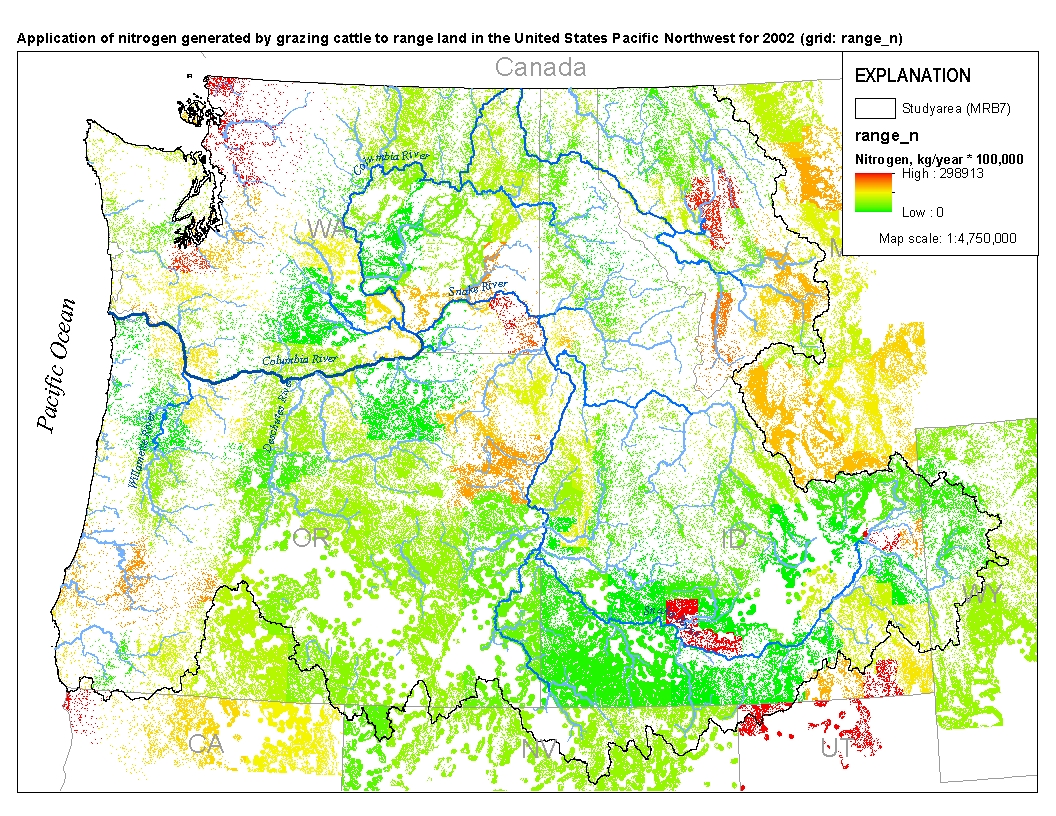
This spatial data set was created by the U.S. Geological Survey (USGS) to represent the amount of nitrogen generated by grazing cattle that was applied to range land in the Pacific Northwest region of the United States (Hydro Region 17; Major River Basin 7 (MRB7)) during 2002.
The RCMAP (Rangeland Condition Monitoring Assessment and Projection) dataset quantifies the percent cover of rangeland components across the western U.S. using Landsat imagery from 1985-2020. The RCMAP product suite consists of eight fractional components: annual herbaceous, bare ground, herbaceous, litter, non-sagebrush shrub, perennial herbaceous, sagebrush, shrub and rule-based error maps including the temporal trends of each component. Several enhancements were made to the RCMAP process relative to prior generations. We used an updated version of the 2016 base training data, with a more aggressive forest mask and reduced shrub and sagebrush cover bias in pinyon-juniper woodlands. We pooled training data in areas...
The RCMAP (Rangeland Condition Monitoring Assessment and Projection) dataset quantifies the percent cover of rangeland components across the western U.S. using Landsat imagery from 1985-2020. The RCMAP product suite consists of eight fractional components: annual herbaceous, bare ground, herbaceous, litter, non-sagebrush shrub, perennial herbaceous, sagebrush, shrub and rule-based error maps including the temporal trends of each component. Several enhancements were made to the RCMAP process relative to prior generations. We used an updated version of the 2016 base training data, with a more aggressive forest mask and reduced shrub and sagebrush cover bias in pinyon-juniper woodlands. We pooled training data in areas...
The RCMAP (Rangeland Condition Monitoring Assessment and Projection) dataset quantifies the percent cover of rangeland components across western North America using Landsat imagery from 1985-2023. The RCMAP product suite consists of ten fractional components: annual herbaceous, bare ground, herbaceous, litter, non-sagebrush shrub, perennial herbaceous, sagebrush, shrub, tree, and shrub height in addition to the temporal trends of each component. Several enhancements were made to the RCMAP process relative to prior generations. First, high-resolution training was revised using an improved neural-net classifier and modelling approach. These data serve as foundation to the RCMAP approach. The training database was...
Climate change over the past century has altered vegetation community composition and species distributions across rangelands in the western United States. The scale and magnitude of climatic influences are largely unknown. While a number of studies have projected the impacts of climate change using several modeling approaches, none has evaluated impacts to fractional component cover at a 30-m resolution across rangelands of the Western U.S. We used fractional component cover data for rangeland functional groups and weather data from the 1985 to 2021 reference period in conjunction with soils and topography data to develop empirical models describing the spatio-temporal variation in component cover. To investigate...
The sagebrush ecosystem spans over 175 million acres in the western United States, and is biologically, culturally, and economically significant to the country. Many disturbances including prolonged drought, pinyon-juniper encroachment, and cycles of invasive grasses and wildfire, pose significant threats to the resilience of the sagebrush biome. To conserve the sagebrush biome and promote community and economic sustainability, the Department of the Interior’s bureaus and offices are working together with many public and private partners to implement a “defend and grow the core” approach to conserve remaining intact sagebrush habitat and ecosystem functions, as well as restore other habitat types which are important...
Types: Map Service,
OGC WFS Layer,
OGC WMS Layer,
OGC WMS Service;
Tags: California,
Colorado,
Conservation,
Ecology,
Idaho,
We quantified baseline and projected change in wildlife habitat, soil organic carbon (SOC), and water supply (recharge and runoff). For six case study watersheds we quantified the interactions of future development and changing climate on recharge, runoff and streamflow, and precipitation thresholds where dominant watershed hydrological processes shift through analysis of covariance.
Categories: Publication;
Types: Journal Citation;
Tags: California,
Climate change adaption,
Downscaled global climate models,
Ecosystem services,
Grassland,
Defining site potential for an area establishes its possible long-term vegetation growth productivity in a relatively undisturbed state, providing a realistic reference point for ecosystem performance. Modeling and mapping site potential helps to measure and identify naturally occurring variations on the landscape as opposed to variations caused by land management activities or disturbances (Rigge et al. 2020). We integrated remotely sensed data (250-m enhanced Moderate Resolution Imaging Spectroradiometer (eMODIS) Normalized Difference Vegetation Index (NDVI) (https://earthexplorer.usgs.gov/)) with land cover, biogeophysical (i.e., soils, topography) and climate data into regression-tree software (Cubist®). We...
Categories: Data;
Types: Downloadable,
GeoTIFF,
Map Service,
Raster;
Tags: Arid,
Arizona,
Colorado,
Ecology,
Geography,
The RCMAP (Rangeland Condition Monitoring Assessment and Projection) dataset quantifies the percent cover of rangeland components across western North America using Landsat imagery from 1985-2023. The RCMAP product suite consists of ten fractional components: annual herbaceous, bare ground, herbaceous, litter, non-sagebrush shrub, perennial herbaceous, sagebrush, shrub, tree, and shrub height in addition to the temporal trends of each component. Several enhancements were made to the RCMAP process relative to prior generations. First, high-resolution training was revised using an improved neural-net classifier and modelling approach. These data serve as foundation to the RCMAP approach. The training database was...
The RCMAP (Rangeland Condition Monitoring Assessment and Projection) dataset quantifies the percent cover of rangeland components across western North America using Landsat imagery from 1985-2023. The RCMAP product suite consists of ten fractional components: annual herbaceous, bare ground, herbaceous, litter, non-sagebrush shrub, perennial herbaceous, sagebrush, shrub, tree, and shrub height in addition to the temporal trends of each component. Several enhancements were made to the RCMAP process relative to prior generations. First, high-resolution training was revised using an improved neural-net classifier and modelling approach. These data serve as foundation to the RCMAP approach. The training database was...
The need to monitor change in sagebrush steppe is urgent due to the increasing impacts of climate change, shifting fire regimes, and management practices on ecosystem health. Remote sensing provides a cost-effective and reliable method for monitoring change through time and attributing changes to drivers. We report an automated method of mapping rangeland fractional component cover over a large portion of the Northern Great Basin, USA, from 1986 to 2016 using a dense Landsat imagery time series. 2012 was excluded from the time-series due to a lack of quality imagery. Our method improved upon the traditional change vector method by considering the legacy of change at each pixel. We evaluate cover trends stratified...
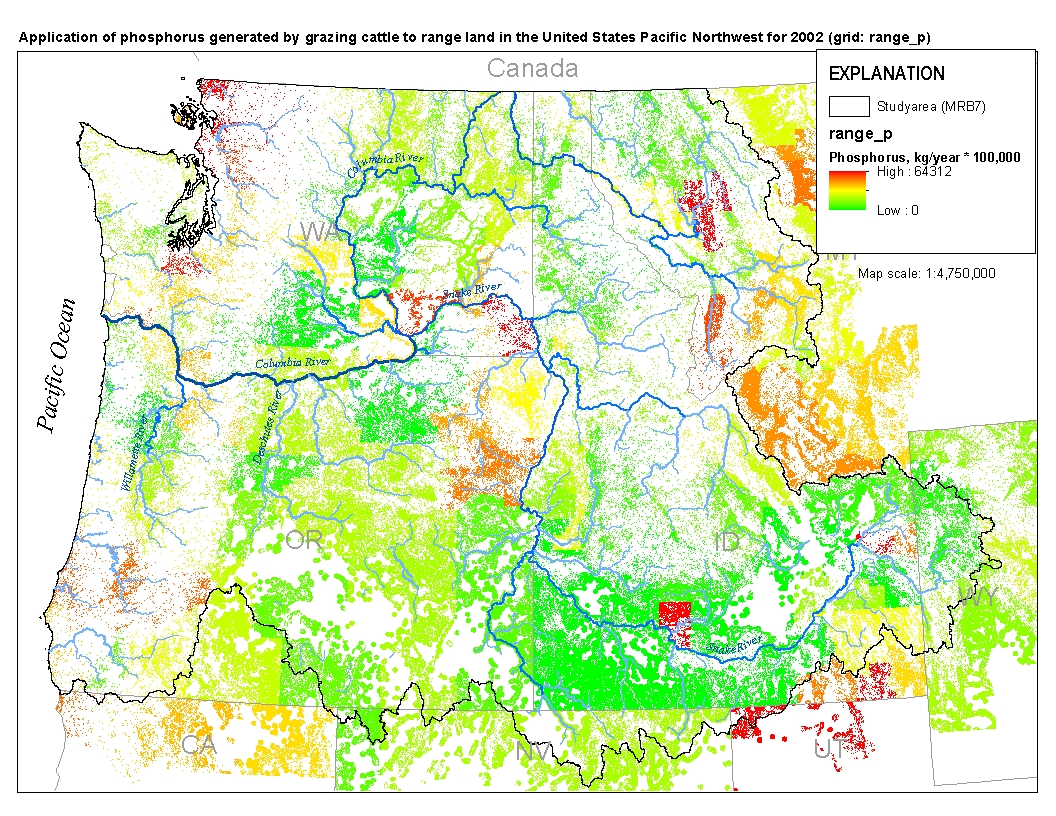
This spatial data set was created by the U.S. Geological Survey (USGS) to represent the amount of phosphorus generated by grazing cattle that was applied to range land in the Pacific Northwest region of the United States (Hydro Region 17; Major River Basin 7 (MRB7)) during 2002.
The RCMAP (Rangeland Condition Monitoring Assessment and Projection) dataset quantifies the percent cover of rangeland components across the western U.S. using Landsat imagery from 1985-2020. The RCMAP product suite consists of eight fractional components: annual herbaceous, bare ground, herbaceous, litter, non-sagebrush shrub, perennial herbaceous, sagebrush, shrub and rule-based error maps including the temporal trends of each component. Several enhancements were made to the RCMAP process relative to prior generations. We used an updated version of the 2016 base training data, with a more aggressive forest mask and reduced shrub and sagebrush cover bias in pinyon-juniper woodlands. We pooled training data in areas...
The RCMAP (Rangeland Condition Monitoring Assessment and Projection) dataset quantifies the percent cover of rangeland components across the western U.S. using Landsat imagery from 1985-2020. The RCMAP product suite consists of eight fractional components: annual herbaceous, bare ground, herbaceous, litter, non-sagebrush shrub, perennial herbaceous, sagebrush, shrub and rule-based error maps including the temporal trends of each component. Several enhancements were made to the RCMAP process relative to prior generations. We used an updated version of the 2016 base training data, with a more aggressive forest mask and reduced shrub and sagebrush cover bias in pinyon-juniper woodlands. We pooled training data in areas...
|

|
