Filters: Tags: Region (X) > Types: ArcGIS REST Map Service (X)
5 results (11ms)|
Filters
Date Range
Extensions Types Contacts
Categories Tag Types Tag Schemes |

The Watershed Boundary Dataset (WBD) from The National Map (TNM) defines the perimeter of drainage areas formed by the terrain and other landscape characteristics. The drainage areas are nested within each other so that a large drainage area, such as the Upper Mississippi River, will be composed of multiple smaller drainage areas, such as the Wisconsin River. Each of these smaller areas can further be subdivided into smaller and smaller drainage areas. The WBD uses six different levels in this hierarchy, with the smallest averaging about 30,000 acres. The WBD is made up of polygons nested into six levels of data respectively defined by Regions, Subregions, Basins, Subbasins, Watersheds, and Subwatersheds. For additional...
This data set is a complete digital hydrologic unit boundary layer of the Subbasin (10-digit) 5th level for the entire United States, clipped to the Northeast. A hydrologic unit (HU) is a drainage area delineated to nest a multi-level, hierarchical drainage system. Its boundaries are defined by a hydrographic and topographic criteria that delineate an area of land upstream from a specific point on a river, stream, or similar surfaces waters. An HU can accept surface water directly from upstream drainage areas, and indirectly from associated surface areas such as remnant, non-contributing, and diversions to form a drainage area with single or multiple outlet points. HUs are only synonymous with classic watersheds...
Categories: Data;
Types: ArcGIS REST Map Service,
ArcGIS Service Definition,
Downloadable,
Map Service;
Tags: Canada,
HUC,
HUC8,
Mexico,
Puerto Rico,
This data set is a complete digital hydrologic unit boundary layer of the Subbasin (8-digit) 4th level for the entire United States, clipped to the Northeast. A hydrologic unit (HU) is a drainage area delineated to nest a multi-level, hierarchical drainage system. Its boundaries are defined by a hydrographic and topographic criteria that delineate an area of land upstream from a specific point on a river, stream, or similar surfaces waters. An HU can accept surface water directly from upstream drainage areas, and indirectly from associated surface areas such as remnant, non-contributing, and diversions to form a drainage area with single or multiple outlet points. HUs are only synonymous with classic watersheds...
Categories: Data;
Types: ArcGIS REST Map Service,
ArcGIS Service Definition,
Downloadable,
Map Service;
Tags: Canada,
HUC,
HUC8,
Mexico,
Puerto Rico,

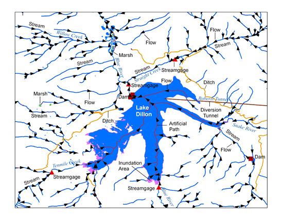
The USGS National Hydrography Dataset (NHD) service from The National Map (TNM) is a comprehensive set of digital spatial data that encodes information about naturally occurring and constructed bodies of surface water (lakes, ponds, and reservoirs), paths through which water flows (canals, ditches, streams, and rivers), and related entities such as point features (springs, wells, stream gages, and dams). The information encoded about these features includes classification and other characteristics, delineation, geographic name, position and related measures, a "reach code" through which other information can be related to the NHD, and the direction of water flow. The network of reach codes delineating water and...
Categories: Data;
Types: ArcGIS REST Map Service,
Map Service;
Tags: HU,
Hydrography,
NGP-TNM,
NHD,
Overlay Map Service,
This data set is a complete digital hydrologic unit boundary layer of the Subbasin (12-digit) 6th level for the entire United States, clipped to the Northeast. A hydrologic unit (HU) is a drainage area delineated to nest a multi-level, hierarchical drainage system. Its boundaries are defined by a hydrographic and topographic criteria that delineate an area of land upstream from a specific point on a river, stream, or similar surfaces waters. An HU can accept surface water directly from upstream drainage areas, and indirectly from associated surface areas such as remnant, non-contributing, and diversions to form a drainage area with single or multiple outlet points. HUs are only synonymous with classic watersheds...
Categories: Data;
Types: ArcGIS REST Map Service,
ArcGIS Service Definition,
Downloadable,
Map Service;
Tags: Canada,
Mexico,
Puerto Rico,
U.S.,
U.S. Territories,
|

|