Filters: Tags: Resident fish (X)
12 results (31ms)|
Filters
Date Range
Extensions Types Contacts Categories Tag Schemes |

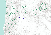
Oregon Fish Habitat Distribution These data describe areas of suitable habitat believed to be used currently by wild, natural, and/or hatchery fish populations. The term "currently" is defined as within the past five reproductive cycles. This information is based on sampling, the best professional opinion of Oregon Dept. of Fish and Wildlife or other natural resources agency staff biologists or modeling (see the fhdBasis field). Due to natural variations in run size, water conditions, or other environmental factors, some habitats identified may not be used annually. These data now comply with the Oregon Fish Habitat Distribution Data Standard that was adopted by the Oregon Geographic Information Council in...

Oregon Fish Habitat Distribution These data describe areas of suitable habitat believed to be used currently by wild, natural, and/or hatchery fish populations. The term "currently" is defined as within the past five reproductive cycles. This information is based on sampling, the best professional opinion of Oregon Dept. of Fish and Wildlife or other natural resources agency staff biologists or modeling (see the fhdBasis field). Due to natural variations in run size, water conditions, or other environmental factors, some habitats identified may not be used annually. These data now comply with the Oregon Fish Habitat Distribution Data Standard that was adopted by the Oregon Geographic Information Council in March,...

Oregon Fish Habitat Distribution These data describe areas of suitable habitat believed to be used currently by wild, natural, and/or hatchery fish populations. The term "currently" is defined as within the past five reproductive cycles. This information is based on sampling, the best professional opinion of Oregon Dept. of Fish and Wildlife or other natural resources agency staff biologists or modeling (see the fhdBasis field). Due to natural variations in run size, water conditions, or other environmental factors, some habitats identified may not be used annually. These data now comply with the Oregon Fish Habitat Distribution Data Standard that was adopted by the Oregon Geographic Information Council in March,...

Oregon Fish Habitat Distribution These data describe areas of suitable habitat believed to be used currently by wild, natural, and/or hatchery fish populations. The term "currently" is defined as within the past five reproductive cycles. This information is based on sampling, the best professional opinion of Oregon Dept. of Fish and Wildlife or other natural resources agency staff biologists or modeling (see the fhdBasis field). Due to natural variations in run size, water conditions, or other environmental factors, some habitats identified may not be used annually. These data now comply with the Oregon Fish Habitat Distribution Data Standard that was adopted by the Oregon Geographic Information Council in March,...
Oregon Fish Habitat Distribution These data describe areas of suitable habitat believed to be used currently by wild, natural, and/or hatchery fish populations. The term "currently" is defined as within the past five reproductive cycles. This information is based on sampling, the best professional opinion of Oregon Dept. of Fish and Wildlife or other natural resources agency staff biologists or modeling (see the fhdBasis field). Due to natural variations in run size, water conditions, or other environmental factors, some habitats identified may not be used annually. These data now comply with the Oregon Fish Habitat Distribution Data Standard that was adopted by the Oregon Geographic Information Council in...

Oregon Fish Habitat Distribution These data describe areas of suitable habitat believed to be used currently by wild, natural, and/or hatchery fish populations. The term "currently" is defined as within the past five reproductive cycles. This information is based on sampling, the best professional opinion of Oregon Dept. of Fish and Wildlife or other natural resources agency staff biologists or modeling (see the fhdBasis field). Due to natural variations in run size, water conditions, or other environmental factors, some habitats identified may not be used annually. These data now comply with the Oregon Fish Habitat Distribution Data Standard that was adopted by the Oregon Geographic Information Council in March,...

Oregon Fish Habitat Distribution These data describe areas of suitable habitat believed to be used currently by wild, natural, and/or hatchery fish populations. The term "currently" is defined as within the past five reproductive cycles. This information is based on sampling, the best professional opinion of Oregon Dept. of Fish and Wildlife or other natural resources agency staff biologists or modeling (see the fhdBasis field). Due to natural variations in run size, water conditions, or other environmental factors, some habitats identified may not be used annually. These data now comply with the Oregon Fish Habitat Distribution Data Standard that was adopted by the Oregon Geographic Information Council in...

Group layer of areas of suitable habitat believed to be used by wild, natural, and/or hatchery fish populations by anadromous fish species.

Oregon Fish Habitat Distribution These data describe areas of suitable habitat believed to be used currently by wild, natural, and/or hatchery fish populations. The term "currently" is defined as within the past five reproductive cycles. This information is based on sampling, the best professional opinion of Oregon Dept. of Fish and Wildlife or other natural resources agency staff biologists or modeling (see the fhdBasis field). Due to natural variations in run size, water conditions, or other environmental factors, some habitats identified may not be used annually. These data now comply with the Oregon Fish Habitat Distribution Data Standard that was adopted by the Oregon Geographic Information Council in March,...

Oregon Fish Habitat Distribution These data describe areas of suitable habitat believed to be used currently by wild, natural, and/or hatchery fish populations. The term "currently" is defined as within the past five reproductive cycles. This information is based on sampling, the best professional opinion of Oregon Dept. of Fish and Wildlife or other natural resources agency staff biologists or modeling (see the fhdBasis field). Due to natural variations in run size, water conditions, or other environmental factors, some habitats identified may not be used annually. These data now comply with the Oregon Fish Habitat Distribution Data Standard that was adopted by the Oregon Geographic Information Council in...
Oregon Fish Habitat Distribution These data describe areas of suitable habitat believed to be used currently by wild, natural, and/or hatchery fish populations. The term "currently" is defined as within the past five reproductive cycles. This information is based on sampling, the best professional opinion of Oregon Dept. of Fish and Wildlife or other natural resources agency staff biologists or modeling (see the fhdBasis field). Due to natural variations in run size, water conditions, or other environmental factors, some habitats identified may not be used annually. These data now comply with the Oregon Fish Habitat Distribution Data Standard that was adopted by the Oregon Geographic Information Council in March,...
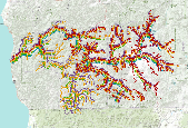
Resident Fish Connectivity This layer was one of the old South Atlantic LCC indicators in the waterscapes ecosystem. It was an index of local barriers to fish and other aquatic species. Resident fish connectivity was not performing well as an indicator and could not be used in Blueprint 2.0. This indicator was replaced in Blueprint 2.1 with a new network complexity indicator. Reason for Selection Barriers to connectivity within rivers/streams can strongly impact aquatic diversity and alter natural movement of sediments, are easy to monitor and model, and are widely used and understood by diverse partners. Input Data Southeast Aquatic Connectivity Assessment Project: This project, a collaboration between The Nature...
Categories: Data;
Types: ArcGIS REST Map Service,
ArcGIS Service Definition,
Downloadable,
Map Service;
Tags: Resident Fish Connectivity,
Resident fish,
aquatic connectivity,
dams,
rivers,
|

|
