Filters
Date Range
Types
Contacts
Tag Types
Tag Schemes
|
This data set contains imagery from the National Agriculture Imagery Program (NAIP). The NAIP program is administered by USDA FSA and has been established to support two main FSA strategic goals centered on agricultural production. These are, increase stewardship of America's natural resources while enhancing the environment, and to ensure commodities are procured and distributed effectively and efficiently to increase food security. The NAIP program supports these goals by acquiring and providing ortho imagery that has been collected during the agricultural growing season in the U.S. The NAIP ortho imagery is tailored to meet FSA requirements and is a fundamental tool used to support FSA farm and conservation programs....
Types: Citation;
Tags: 22111,
3.75 x 3.75 minute,
3209223,
Aerial Compliance,
Compliance, All tags...
Digital Ortho rectified Image,
Downloadable Data,
JPEG2000,
LA,
LA111,
NAIP,
Ortho Rectification,
Orthoimagery,
Quarter Quadrangle,
ROCKY BRANCH,
ROCKY BRANCH, NE,
UNION PARISH LA FSA,
USDA National Agriculture Imagery Program (NAIP),
Union,
farming, Fewer tags
This data set contains imagery from the National Agriculture Imagery Program (NAIP). The NAIP program is administered by USDA FSA and has been established to support two main FSA strategic goals centered on agricultural production. These are, increase stewardship of America's natural resources while enhancing the environment, and to ensure commodities are procured and distributed effectively and efficiently to increase food security. The NAIP program supports these goals by acquiring and providing ortho imagery that has been collected during the agricultural growing season in the U.S. The NAIP ortho imagery is tailored to meet FSA requirements and is a fundamental tool used to support FSA farm and conservation programs....
Types: Citation;
Tags: 22111,
3.75 x 3.75 minute,
3209223,
Aerial Compliance,
Compliance, All tags...
Digital Ortho rectified Image,
Downloadable Data,
JPEG2000,
LA,
LA111,
NAIP,
Ortho Rectification,
Orthoimagery,
Quarter Quadrangle,
ROCKY BRANCH,
ROCKY BRANCH, SW,
UNION PARISH LA FSA,
USDA National Agriculture Imagery Program (NAIP),
Union,
farming, Fewer tags

The database for the Preliminary Geologic Map of the Cherry Hill Quadrangle, Dinwiddie, Sussex, and Greensville Counties, Virginia geographically straddles the Coastal Plain and Piedmont Provinces along the Tidewater Fall Line. Rocks of the eastern Piedmont Roanoke Rapids terrane crop out in the western part of the quadrangle and consist of greenschist- to amphibolite-facies Neoproterozoic felsic to intermediate metavolcanic rocks, some of which contain flattened quartz phenocrysts and are locally isoclinally folded; greenstone that is locally primary layered; and intrusive metadiorite and metagabbro, much of which has been altered to amphibolite. Most of these rocks are strongly foliated and jointed. Greenschist-facies...
Tags: Alluvial terrace,
Alluvium,
Amphibolite,
Aplite,
Atlantic coastal plain, All tags...
Bacons Castle Formation,
Black Branch,
Cambrian,
Cataclasite,
Cherry Hill,
Chesapeake Group,
Clastic rock,
Clay or mud,
Coarse-grained mixed clastic rock,
Colluvium,
De Witt pluton,
Devonian,
Dinwiddie County,
Dinwiddie terrane,
Double Branch Creek,
Economic Geology,
Felsic metavolcanic rock,
Gabbroid,
Geochemistry,
Geomorphology,
Granite,
Granitoid,
Gravel,
Greenstone,
Greenville County,
Hardwood Creek,
Harris Swamp,
Holocene,
Horsepen Branch,
Intermediate metavolcanic rock,
Lake or marine sediment,
Landslide,
Manlove Branch,
Mayes Pond,
Mesozoic,
Metamorphic rock,
Metasedimentary rock,
Metavolcanic rock,
Mica schist,
Millrun Branch,
Mineral Resources,
Miocene,
Mixed volcanic/clastic rock,
Mylonite,
Neogene,
Neoproterozoic,
Nottoway River,
Nottoway River fault zone,
Open-File Report,
Paleozoic,
Pegmatite,
Pennsylvanian,
Pleistocene,
Pliocene,
Plutonic rock,
Quartzite,
Quaternary,
Rita Branch,
Roanoke Rapids terrane,
Rocky Branch,
Sand,
Sandstone,
Sappony Creek,
Schist,
Sedimentology,
Silurian,
Smith Branch,
Spring Meadow Branch,
Stewart Branch,
Stratigraphy,
Structural Geology,
Sussex County,
Terrace,
USGS Science Data Catalog (SDC),
Unconsolidated material,
Virginia,
bedrock geologic units,
building stone resources,
deformation (geologic),
earth characteristics,
earth sciences,
environment,
fault zones,
faulting (geologic),
faults,
foliation (geologic),
fracture (geologic),
gabbro,
geochemistry,
geologic contacts,
geologic history,
geologic maps,
geologic structure,
geology,
geoscientificInformation,
geospatial datasets,
gravel deposits,
igneous rocks,
lineation (geologic),
lithostratigraphy,
maps and atlases,
metallic mineral resources,
metamorphic rocks,
metamorphism (geological),
mine sites,
mineral resources,
natural resources,
natural rock formations,
petrology,
plutonic rocks,
rocks and deposits,
sand deposits,
sedimentary rocks,
sedimentology,
silt,
stratigraphy,
structural geology,
study areas,
surficial geologic units,
unconsolidated deposits,
volcanic rocks, Fewer tags
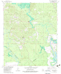
USGS Historical Quadrangle in GeoPDF.
Tags: 7.5 x 7.5 minute,
Downloadable Data,
GeoPDF,
GeoTIFF,
Historical Topographic Maps, All tags...
Historical Topographic Maps 7.5 x 7.5 Minute Map Series,
LA,
Map,
Rocky Branch,
imageryBaseMapsEarthCover, Fewer tags
This data set contains imagery from the National Agriculture Imagery Program (NAIP). The NAIP program is administered by USDA FSA and has been established to support two main FSA strategic goals centered on agricultural production. These are, increase stewardship of America's natural resources while enhancing the environment, and to ensure commodities are procured and distributed effectively and efficiently to increase food security. The NAIP program supports these goals by acquiring and providing ortho imagery that has been collected during the agricultural growing season in the U.S. The NAIP ortho imagery is tailored to meet FSA requirements and is a fundamental tool used to support FSA farm and conservation programs....
Types: Citation;
Tags: 22111,
3.75 x 3.75 minute,
3209223,
Aerial Compliance,
Compliance, All tags...
Digital Ortho rectified Image,
Downloadable Data,
JPEG2000,
LA,
LA111,
NAIP,
Ortho Rectification,
Orthoimagery,
Quarter Quadrangle,
ROCKY BRANCH,
ROCKY BRANCH, NW,
UNION PARISH LA FSA,
USDA National Agriculture Imagery Program (NAIP),
Union,
farming, Fewer tags

The 1:100,000-scale geologic map database of the South Boston 30' × 60' quadrangle, Virginia and North Carolina, provides geologic information for the Piedmont along the I-85 and U.S. Route 58 corridors and in the Roanoke River watershed, which includes the John H. Kerr Reservoir and Lake Gaston. The Raleigh terrane (located on the eastern side of the map) contains Neoproterozoic to early Paleozoic(?) polydeformed, amphibolite-facies gneisses and schists. The Carolina slate belt of the Carolina terrane (located in the central part of the map) contains Neoproterozoic metavolcanic and metasedimentary rocks at greenschist facies. Although locally complicated, the slate-belt structure mapped across the South Boston...
Tags: 30 x 60 minute,
Aaron Formation,
Aarons Creek,
Alkaline basalt,
Allen Creek, All tags...
Alluvium,
Amphibolite,
Argillite,
Armistead Branch,
Ashcake Creek,
Augen gneiss,
Averett,
Bagleys Mills,
Banister Lake,
Banister River,
Barnes Junction,
Basalt,
Baskerville,
Bears Element Creek,
Beaver Pond,
Beaver Pond Creek,
Beech Creek,
Bethel Hill,
Big Hounds Creek,
Big Juniper Creek,
Biotite gneiss,
Birch Creek,
Bishops Corner,
Black Walnut Creek,
Blackridge,
Blackstone Creek,
Blanes Millpond,
Bluestone Creek,
Bluestone Otter Creek,
Bluewing Creek,
Bowes Branch,
Boydton,
Bracey,
Brodnax,
Brunswick County,
Buckham Creek,
Buckhorn Creek,
Buckskin Creek,
Buffalo Creek,
Buffalo Junction,
Buffalo Springs,
Buggs Island,
Burton Branch,
Butcher Creek,
Cambrian,
Cargills Creek,
Carolina slate belt,
Carolina terrane,
Castle Creek,
Castle Heights,
Cataclasite,
Catawba Creek,
Cedar Creek,
Cenozoic,
Charlotte County,
Chase City,
Christie,
Clarksville,
Clarkton,
Clays Mill,
Clover,
Clover Creek,
Cluster Springs,
Coleman Creek,
Colluvium,
Conglomerate,
Connor Lake,
Cotton Creek,
Couches Creek,
Country Line complex,
Cox Creek,
Crooked Creek,
Crupper Run,
Crystal Hill,
Cub Creek,
Cunningham complex,
Dacite,
Dan River,
Devils Branch,
Devonian,
Diabase,
Difficult Creek,
Diorite,
Dixon Millpond,
Dockery Creek,
Drakes Branch,
Dryburg,
Dudley,
Dundas,
Ellis Creek,
Esnon,
Evans Creek,
Farmers Branch,
Felsic gneiss,
Finchley,
Finnewood Creek,
Finneywood,
Flat Creek,
Flat Rock Creek,
Forksville,
Formosa,
Fort Mitchell,
Gabbro,
Gibson Creek,
Gilliams Branch,
Gneiss,
Goodell Creek,
Granite,
Granitic gneiss,
Granodiorite,
Granville County,
Grassy Creek,
Great Creek,
Greenschist,
Gregory Corner,
Hagood Creek,
Halifax,
Halifax County,
Harmony,
Hawtree Creek,
Hitesburg,
Holocene,
Horsepen Creek,
Horseshoe Lake,
Hughs Lake,
Hunting Creek,
Hyco Formation,
Hyco River,
Island Creek,
Island Creek Reservoir,
Jeffress,
Johnson Creek,
Jurassic,
Kenbridge,
Kerr Reservoir,
Kettle Creek,
Kettlesticks Creek,
Kits Creek,
La Crosse,
Lake Gaston,
Lake Gordon,
Langford Pond,
Lawsons Creek,
Layton Creek,
Lennig,
Little Genito Creek,
Little Horsepen Creek,
Little Johnson Creek,
Little Juniper Creek,
Little Temble Creek,
Long Branch,
Lunenburg,
Lunenburg County,
Lyle Creek,
Marengo,
Mason Creek,
Mayo,
Mayo Creek,
Mayo Reservoir,
Mecklenburg County,
Mesozoic,
Metabasalt,
Metamorphic rock,
Metamorphic suite of South Hill,
Metasedimentary rock,
Metavolcanic rock,
Middle Meherrin River,
Mikes Creek,
Miles Creek,
Mill Branch,
Milton terrane,
Mines Creek,
Miocene,
Miry Creek,
Mississippian,
Mitchell Creek,
Monzodiorite,
Monzonite,
Moody Creek,
Mossingford,
Mount Laurel,
Mountain Creek,
Mylonite,
Nathalie,
Nelson,
Neogene,
Neoproterozoic,
North Carolina,
North Meherrin River,
North View,
Nutbush Creek,
Nutbush Creek mylonite zone,
Omega,
Ontario,
Ordovician,
Orthogneiss,
Otter Creek,
Paleozoic,
Palmer Crossroads,
Palmer Springs,
Panhandle Creek,
Parham Creek,
Pennsylvanian,
Permian,
Person County,
Peter Creek,
Philbeck Crossroads,
Phyllonite,
Piney Creek,
Piney Grove,
Plantersville,
Pleistocene,
Pliocene,
Poplar Creek,
Public Fork,
Quartz diorite,
Quartz monzonite,
Quartzite,
Quaternary,
Rabat,
Raleigh terrane,
Randolph,
Ready Creek,
Red Bank,
Red Oak,
Redlawn,
Reedy Creek,
Reeses Creek,
Rehoboth,
Reynolds Creek,
Rhyolite,
Riverdale,
Roanoke Creek,
Roanoke River,
Rocky Branch,
Sand,
Sandy Creek,
Saxe,
Schist,
Scotts Crossroad,
Scottsburg,
Seay Creek,
Shiny Rock,
Siddon,
Siltstone,
Silurian,
Sinai,
Skipwith,
Smith Creek,
South Boston,
South Hill,
South Meherrin River,
Spanish Grove,
Stokes Creek,
Stony Creek,
Taylors Creek,
Temble Creek,
Terrace,
The Ridge,
Tonalite,
Triassic,
Tungsten,
Twittys Creek,
USGS Science Data Catalog (SDC),
Union Level,
Vance County,
Vance pluton,
Victoria,
Virgilina,
Virgilina Formation,
Virginia,
Wallace Branch,
Warren County,
Wightman,
Winn Creek,
Wolf Trap Creek,
Wylliesburg,
abandoned mines and quarries,
bedrock geologic units,
copper,
earth sciences,
folding (geologic),
foliation (geologic),
fracture (geologic),
geologic contacts,
geologic maps,
geologic processes,
geologic structure,
geologic time periods,
geologic time scales,
geology,
geoscientificInformation,
geospatial datasets,
information product types,
inlandWaters,
lithology,
maps and atlases,
metamorphic rocks,
metamorphism (geological),
mining and quarrying,
place,
sedimentary rocks,
sedimentation,
society,
stratum,
structural geology,
structure,
surficial geologic units,
unconsolidated deposits,
utilitiesCommunication, Fewer tags
This data set contains imagery from the National Agriculture Imagery Program (NAIP). The NAIP program is administered by USDA FSA and has been established to support two main FSA strategic goals centered on agricultural production. These are, increase stewardship of America's natural resources while enhancing the environment, and to ensure commodities are procured and distributed effectively and efficiently to increase food security. The NAIP program supports these goals by acquiring and providing ortho imagery that has been collected during the agricultural growing season in the U.S. The NAIP ortho imagery is tailored to meet FSA requirements and is a fundamental tool used to support FSA farm and conservation programs....
Types: Citation;
Tags: 22111,
3.75 x 3.75 minute,
3209223,
Aerial Compliance,
Compliance, All tags...
Digital Ortho rectified Image,
Downloadable Data,
JPEG2000,
LA,
LA111,
NAIP,
Ortho Rectification,
Orthoimagery,
Quarter Quadrangle,
ROCKY BRANCH,
ROCKY BRANCH, SE,
UNION PARISH LA FSA,
USDA National Agriculture Imagery Program (NAIP),
Union,
farming, Fewer tags
|
|

