Filters: Tags: SALT (X)
26 results (8ms)|
Filters
Date Range
Extensions Types
Contacts
Categories Tag Types
|
This data release contains the U.S. salient statistics and world production data extracted from the SALT data sheet of the USGS Mineral Commodity Summaries 2022.
This data release contains the U.S. salient statistics and world production data extracted from the SALT data sheet of the USGS Mineral Commodity Summaries 2024.
This map shows the current and near-term status of aquatic ecosystems, in addition to the input datasets used for the analysis and distribution modeling that were involved in producing these status datasets. These data are provided by Bureau of Land Management (BLM) "as is" and may contain errors or omissions. The User assumes the entire risk associated with its use of these data and bears all responsibility in determining whether these data are fit for the User's intended use. These data may not have the accuracy, resolution, completeness, timeliness, or other characteristics appropriate for applications that potential users of the data may contemplate. The User is encouraged to carefully consider the content of...
Core Research Center, core B444, from well operated by AMERADA HESS CORPRaw Properties from download, web scrape, MapServer, and Macrostrat API{"Lib Num": "B444", "API Num": "2509105118", "Operator": "AMERADA HESS CORP", "Well Name": "1 WEXELS", "Field": "OUTLOOK", "State": "MT", "County": "SHERIDAN", "Type": "SLABBED", "Photos": "T", "Thin Sec": "F", "Analysis": "F", "Latitude": "48.865242", "Longitude": "-104.865825", "coordinates_geohash": "c8tmvxxh9jm6", "Source": "FROM STATE RECORDS", "Security Flag": "NO SPECIAL RESTRICTIONS", "crc_collection_name": "core", "sb_parent_id": "4f4e49dae4b07f02db5e0486", "intervals": [{"Formation": "SALT", "Age": "UNKN", "Min Depth": "8975", "Max Depth": "9056"}, {"Formation":...
Categories: Physical Item;
Tags: Danian,
JURA,
Lebo Member,
Lebo Member of Fort Union Formation,
SALT,
The U.S. Geological Survey (USGS) has compiled a geodatabase containing mineral-related geospatial data for 19 countries of interest in the Indo-Pacific region (area of study): Bangladesh, Bhutan, Brunei, Burma, Fiji, Malaysia, Mongolia, Nauru, New Caledonia, New Zealand, Papua New Guinea, Philippines, Singapore, Solomon Islands, South Korea (Republic of Korea), Sri Lanka, Taiwan, Timor-Leste, and Vietnam. The data can be used in analyses of the extractive fuel and nonfuel mineral industries integral for the successful operation of the mineral industries within the area of study. This geodatabase reflects the USGS ongoing commitment to its mission of understanding the nature and distribution of global mineral commodity...
Types: Map Service,
OGC WFS Layer,
OGC WMS Layer,
OGC WMS Service;
Tags: Asia,
Bangladesh,
Bhutan,
Brunei,
Burma,
This data release contains the U.S. salient statistics and world production data extracted from the SALT data sheet of the USGS Mineral Commodity Summaries 2023.
This dataset represents salt marsh communities in the Northeast Atlantic coast. The classification was produced using a combination of Digital Elevation Model (DEM) and National Agriculture Imagery Program (NAIP) multispectral imagery. This dataset combined with "Tidal Marsh Vegetation Classification, no DEM, 3m, Northeast U.S." provides a contiguous classification of tidal marsh cover types from coastal Maine to Virginia. The eight distinct cover/community types identified are: High marsh: Area flooded during spring tides related to the lunar cycle and dominated by Spartina patens, Distichlis spicata, Juncus gerardii, and short form Spartina alterniflora. Other species include Juncus roemerianus, Scirpus pungens,...
Categories: Data;
Types: ArcGIS REST Map Service,
ArcGIS Service Definition,
Downloadable,
Map Service;
Tags: coast,
hurricane sandy,
marsh,
salt,
sea level rise,
This dataset represents salt marsh communities in the Northeast Atlantic coast. The classification was produced using National Agriculture Imagery Program (NAIP) multispectral imagery for areas where no DEM was available to complete the full classification. This dataset combined with "Tidal Marsh Vegetation Classification, DEM, Northeast U.S." provides a contiguous classification of tidal marsh cover types from coastal Maine to Virginia. The six distinct cover/community types identified are: 1. High marsh: Area flooded during spring tides related to the lunar cycle and dominated by Spartina patens, Distichlis spicata, Juncus gerardii, and short form Spartina alterniflora. Other species include Juncus roemerianus,...
Categories: Data;
Types: ArcGIS REST Map Service,
ArcGIS Service Definition,
Downloadable,
Map Service;
Tags: coast,
hurricane sandy,
marsh,
salt,
sea level rise,
The U.S. Geological Survey (USGS) has compiled a geodatabase containing mineral-related geospatial data for the People's Republic of China. The data can be used in analyses of the extractive fuel and nonfuel mineral industries and related economic and physical infrastructure integral for the successful operation of the mineral industries within the area of study as well as the movement of mineral products across domestic and global markets. This geodatabase reflects the USGS ongoing commitment to its mission of understanding the nature and distribution of global mineral commodity supply chains by updating and publishing the georeferenced locations of mineral commodity production and processing facilities, mineral...
Bromus tectorum L. is a non-native, annual grass that has invaded western North America. In SE Utah, B. tectorum generally occurs in grasslands dominated by the native perennial grass, Hilaria jamesii (Torr.) Benth. and rarely where the natives Stipa hymenoides Roem. and Schult. and S. comata Trin. & Rupr. are dominant. This patchy invasion is likely due to differences in soil chemistry. Previous laboratory experiments investigated using soil amendments that would allow B. tectorum to germinate but would reduce B. tectorum emergence without affecting H. jamesii. For this study we selected the most successful treatments (CaCl2, MgCl2, NaCl and zeolite) from a previous laboratory study and applied them in the field...
Categories: Publication;
Types: Citation,
Journal Citation;
Tags: Plant and Soil,
Springer Netherlands,
amendments,
invasion,
nutrients,
Core Research Center, core C496, from well operated by AMERADA HESS CORPRaw Properties from download, web scrape, MapServer, and Macrostrat API{"Lib Num": "C496", "API Num": "2509105104", "Operator": "AMERADA HESS CORP", "Well Name": "1 CHES GRANT TRACT 2", "Field": "OUTLOOK", "State": "MT", "County": "SHERIDAN", "Type": "SLABBED", "Photos": "F", "Thin Sec": "F", "Analysis": "F", "Latitude": "48.843534", "Longitude": "-104.844358", "coordinates_geohash": "c8tmy5wwjqsm", "Source": "FROM STATE RECORDS", "Security Flag": "NO SPECIAL RESTRICTIONS", "crc_collection_name": "core", "sb_parent_id": "4f4e49dae4b07f02db5e0486", "intervals": [{"Formation": "SALT", "Age": "UNKN", "Min Depth": "9223", "Max Depth": "9369"}],...
Categories: Physical Item;
Tags: Danian,
Lebo Member,
Lebo Member of Fort Union Formation,
SALT,
coal,
The U.S. Geological Survey (USGS) has compiled a geodatabase containing mineral-related geospatial data for 10 countries of interest in Southwest Asia (area of study): Afghanistan, Cambodia, Laos, India, Indonesia, Iran, Nepal, North Korea, Pakistan, and Thailand. The data can be used in analyses of the extractive fuel and nonfuel mineral industries and related economic and physical infrastructure integral for the successful operation of the mineral industries within the area of study as well as the movement of mineral products across domestic and global markets. This geodatabase reflects the USGS ongoing commitment to its mission of understanding the nature and distribution of global mineral commodity supply chains...

This data set includes mineral and metal operations in the United States. The data represent commodities monitored by the National Minerals Information Center of the USGS, and the operations included are those considered active in 2003 and surveyed by the MIT. Additional mineral and metal operations information can be obtained from the U.S. Geological Survey National Minerals Information Center web page at: <http://minerals.usgs.gov/minerals/>
Three types of data (one with an elevation model (DEM), one without a DEM, and one indicating the difference) are provided for the entire Northeast region and by analysis zone (n=8). Tidal Marsh Vegetation Classification, DEM, 3m, Northeast U.S. – contains a regional classification produced using a combination of Digital Elevation Model (DEM) and National Agriculture Imagery Program (NAIP) multispectral imagery. All eight cover types are included in this classification. This dataset combined with “Tidal Marsh Vegetation Classification, DEM, 3m, Northeast U.S” provides a contiguous classification of tidal marsh cover types from coastal Maine to Virginia. The eight cover types include: High marsh: Area flooded during...
Categories: Data;
Tags: Data,
LCC Network Science Catalog,
North Atlantic Landscape Conservation Cooperative Data.gov,
coast,
completed,
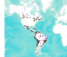
This data set consists of records for over 900 mineral facilities in Latin America and Canada. The mineral facilities include mines, plants, smelters, or refineries of aluminum, cement, coal, copper, diamond, gold, iron and steel, nickel, platinum-group metals, salt, and silver, among others. Records include attributes such as commodity, country, location, company name, facility type and capacity if applicable, and generalized coordinates. The data were compiled from multiple sources, including the 2003 and 2004 USGS Minerals Yearbooks (Latin America and Candada volume), data to be published in the 2005 Minerals Yearbook Latin America and Canada Volume, minerals statistics and information from the USGS minerals...

This dataset consists of records for over 1,500 mineral facilities in Africa and the Middle East. The mineral facilities include mines, plants, mills , or refineries of aluminum, cement, coal, copper, diamond, gold, iron and steel, nickel, platinum-group metals, salt, and silver, among others. Records include attributes such as commodity, country, site, company name, plant capacity if applicable, and generalized coordinates. The data were compiled from multiple sources, including the 2004 USGS Minerals Yearbook (Africa and Middle East volume), minerals statistics and information from the USGS minerals information Web site (http://minerals.usgs.gov/minerals/), and data collected by USGS minerals information country...
This map shows the current and near-term status of aquatic ecosystems, in addition to the input datasets used for the analysis and distribution modeling that were involved in producing these status datasets. These data are provided by Bureau of Land Management (BLM) "as is" and may contain errors or omissions. The User assumes the entire risk associated with its use of these data and bears all responsibility in determining whether these data are fit for the User's intended use. These data may not have the accuracy, resolution, completeness, timeliness, or other characteristics appropriate for applications that potential users of the data may contemplate. The User is encouraged to carefully consider the content of...
Core Research Center, core C294, from well operated by SUN OIL COMPANYRaw Properties from download, web scrape, MapServer, and Macrostrat API{"Lib Num": "C294", "API Num": "2509105087", "Operator": "SUN OIL COMPANY", "Well Name": "1 STATE KITTELSON", "Field": "GOOSE LAKE", "State": "MT", "County": "SHERIDAN", "Type": "SLABBED", "Photos": "F", "Thin Sec": "F", "Analysis": "F", "Latitude": "48.825587", "Longitude": "-104.052954", "coordinates_geohash": "c8wjb0qvwmn5", "Source": "FROM STATE RECORDS", "Security Flag": "NO SPECIAL RESTRICTIONS", "crc_collection_name": "core", "sb_parent_id": "4f4e49dae4b07f02db5e0486", "intervals": [{"Formation": "SALT", "Age": "UNKN", "Min Depth": "6833", "Max Depth": "6852"}, {"Formation":...
Core Research Center, core C606, from well operated by AMERADA HESS CORPRaw Properties from download, web scrape, MapServer, and Macrostrat API{"Lib Num": "C606", "API Num": "2509105139", "Operator": "AMERADA HESS CORP", "Well Name": "1 J H GRINKER", "Field": "OUTLOOK", "State": "MT", "County": "SHERIDAN", "Type": "SLABBED", "Photos": "F", "Thin Sec": "F", "Analysis": "F", "Latitude": "48.937556", "Longitude": "-104.895698", "coordinates_geohash": "c8tqmhc3cjds", "Source": "FROM STATE RECORDS", "Security Flag": "NO SPECIAL RESTRICTIONS", "crc_collection_name": "core", "sb_parent_id": "4f4e49dae4b07f02db5e0486", "intervals": [{"Formation": "SALT", "Age": "UNKN", "Min Depth": "8953", "Max Depth": "9110"}, {"Formation":...
Categories: Physical Item;
Tags: Danian,
Lebo Member,
Lebo Member of Fort Union Formation,
SALT,
SALT,
Note: this data release has been superseded by version 2.0, available here: https://doi.org/10.5066/P97NJLI4.
Categories: Data;
Types: ArcGIS REST Map Service,
ArcGIS Service Definition,
Downloadable,
Map Service;
Tags: Alaska,
Arizona,
BLM,
Bureau of Land Management,
California,
|

|
