Filters: Tags: SHANNON (X)
746 results (43ms)|
Filters
Date Range
Types Contacts
Categories Tag Types Tag Schemes |
Core Research Center, core D935, from well operated by CARDINAL DRILLINGRaw Properties from download, web scrape, MapServer, and Macrostrat API{"Lib Num": "D935", "API Num": "2508721308", "Operator": "CARDINAL DRILLING", "Well Name": "4-3 GREENLEAF", "Field": "WILDCAT", "State": "MT", "County": "ROSEBUD", "Type": "SLABBED", "Photos": "F", "Thin Sec": "F", "Analysis": "F", "Latitude": "45.78678", "Longitude": "-106.541469", "coordinates_geohash": "c8hhrx4z7f6t", "Source": "FROM STATE RECORDS", "Security Flag": "NO SPECIAL RESTRICTIONS", "crc_collection_name": "core", "sb_parent_id": "4f4e49dae4b07f02db5e0486", "intervals": [{"Formation": "SHANNON", "Age": "CRET", "Min Depth": "5439", "Max Depth": "5456"}, {"Formation":...
Core Research Center, core E148, from well operated by WOODS PETROLEUMRaw Properties from download, web scrape, MapServer, and Macrostrat API{"Lib Num": "E148", "API Num": "4900525930", "Operator": "WOODS PETROLEUM", "Well Name": "7-26 PINETREE UNIT", "Field": "PINETREE", "State": "WY", "County": "CAMPBELL", "Type": "SLABBED", "Photos": "T", "Thin Sec": "F", "Analysis": "F", "Latitude": "43.62373", "Longitude": "-105.92123", "coordinates_geohash": "9xu8jtqw8kwm", "Source": "FROM STATE RECORDS", "Security Flag": "NO SPECIAL RESTRICTIONS", "crc_collection_name": "core", "sb_parent_id": "4f4e49dae4b07f02db5e0486", "intervals": [{"Formation": "SHANNON", "Age": "CRET", "Min Depth": "10251", "Max Depth": "10299"}], "crcwc_url":...
Core Research Center, core S624, from well operated by DAVIS OIL COMPANYRaw Properties from download, web scrape, MapServer, and Macrostrat API{"Lib Num": "S624", "API Num": "4901920625", "Operator": "DAVIS OIL COMPANY", "Well Name": "61 CULP DRAW UNIT", "Field": "WC", "State": "WY", "County": "JOHNSON", "Type": "SLABBED", "Photos": "T", "Thin Sec": "F", "Analysis": "F", "Latitude": "44.01292", "Longitude": "-106.10437", "coordinates_geohash": "9xud3s31ufzq", "Source": "FROM STATE RECORDS", "Security Flag": "NO SPECIAL RESTRICTIONS", "crc_collection_name": "core", "sb_parent_id": "4f4e49dae4b07f02db5e0486", "intervals": [{"Formation": "SHANNON", "Age": "CRETACEOUS", "Min Depth": "8875", "Max Depth": "8905"}, {"Formation":...
Core Research Center, cutting HH01747, from well operated by SPYGLASS CEDAR CREEKRaw Properties from download, web scrape, MapServer, and Macrostrat API{"Lib Num": "HH01747", "API Num": "4006320641", "Operator": "SPYGLASS CEDAR CREEK", "Well Name": "8-8 STATE", "Field": "JUMPOFF", "State": "SD", "County": "HARDING", "Thin Sec": "F", "Analysis": "T", "Latitude": "45.45352", "Longitude": "-103.65091", "coordinates_geohash": "c8n696e9ywr8", "Source": "PROVIDED BY DONOR", "Min": "470", "Max": "1932", "Security Flag": null, "crc_collection_name": "cutting", "sb_parent_id": "4f4e49d8e4b07f02db5df2d2", "intervals": [{"Formation": "SHANNON", "Age": "CRETACEOUS", "Min Depth": "1594", "Max Depth": "1932"}, {"Formation": "EAGLE",...
Categories: Physical Item;
Tags: CRETACEOUS,
CRETACEOUS,
EAGLE,
Hell Creek Formation,
Hell Creek Formation,
Core Research Center, core A937, from well operated by FENIX & SCISSONRaw Properties from download, web scrape, MapServer, and Macrostrat API{"Lib Num": "A937", "API Num": "4902510312", "Operator": "FENIX & SCISSON", "Well Name": "71-SX-15", "Field": "TEAPOT DOME", "State": "WY", "County": "NATRONA", "Type": "SLABBED", "Photos": "T", "Thin Sec": "T", "Analysis": "T", "Latitude": "43.27004", "Longitude": "-106.19536", "coordinates_geohash": "9xsqpmnfkb06", "Source": "FROM STATE RECORDS", "Security Flag": "NO SPECIAL RESTRICTIONS", "crc_collection_name": "core", "sb_parent_id": "4f4e49dae4b07f02db5e0486", "intervals": [{"Formation": "SHANNON", "Age": "CRET", "Min Depth": "389", "Max Depth": "509"}], "crcwc_url": "https://my.usgs.gov/crcwc/core/report/8699",...
Core Research Center, core S612, from well operated by DAVIS OIL COMPANYRaw Properties from download, web scrape, MapServer, and Macrostrat API{"Lib Num": "S612", "API Num": "4900922103", "Operator": "DAVIS OIL COMPANY", "Well Name": "1 GYRFALCON FEDERAL", "Field": "UNNAMED", "State": "WY", "County": "CONVERSE", "Type": "THICK SLAB", "Photos": "T", "Thin Sec": "T", "Analysis": "T", "Latitude": "43.45824", "Longitude": "-105.95451", "coordinates_geohash": "9xsxhzq68gp5", "Source": "FROM STATE RECORDS", "Security Flag": "NO SPECIAL RESTRICTIONS", "crc_collection_name": "core", "sb_parent_id": "4f4e49dae4b07f02db5e0486", "intervals": [{"Formation": "SHANNON", "Age": "CRET", "Min Depth": "10630", "Max Depth": "10690"}],...
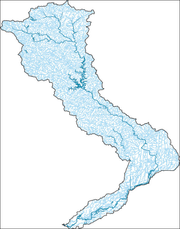
The National Hydrography Dataset (NHD) is a feature-based database that interconnects and uniquely identifies the stream segments or reaches that make up the nation's surface water drainage system. NHD data was originally developed at 1:100,000-scale and exists at that scale for the whole country. This high-resolution NHD, generally developed at 1:24,000/1:12,000 scale, adds detail to the original 1:100,000-scale NHD. (Data for Alaska, Puerto Rico and the Virgin Islands was developed at high-resolution, not 1:100,000 scale.) Local resolution NHD is being developed where partners and data exist. The NHD contains reach codes for networked features, flow direction, names, and centerline representations for areal water...
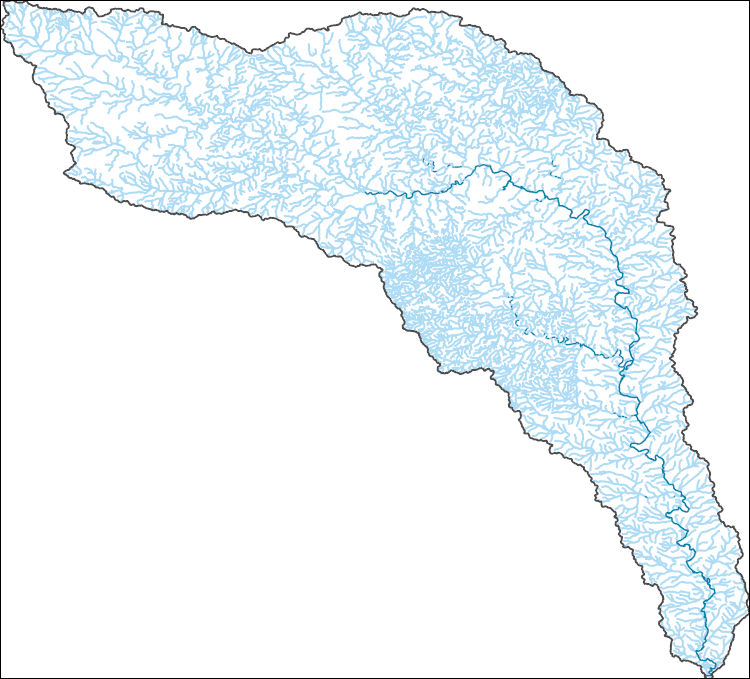
The National Hydrography Dataset (NHD) is a feature-based database that interconnects and uniquely identifies the stream segments or reaches that make up the nation's surface water drainage system. NHD data was originally developed at 1:100,000-scale and exists at that scale for the whole country. This high-resolution NHD, generally developed at 1:24,000/1:12,000 scale, adds detail to the original 1:100,000-scale NHD. (Data for Alaska, Puerto Rico and the Virgin Islands was developed at high-resolution, not 1:100,000 scale.) Local resolution NHD is being developed where partners and data exist. The NHD contains reach codes for networked features, flow direction, names, and centerline representations for areal water...
This data set contains imagery from the National Agriculture Imagery Program (NAIP). The NAIP program is administered by USDA FSA and has been established to support two main FSA strategic goals centered on agricultural production. These are, increase stewardship of America's natural resources while enhancing the environment, and to ensure commodities are procured and distributed effectively and efficiently to increase food security. The NAIP program supports these goals by acquiring and providing ortho imagery that has been collected during the agricultural growing season in the U.S. The NAIP ortho imagery is tailored to meet FSA requirements and is a fundamental tool used to support FSA farm and conservation programs....
Heinrichs Geoexploration Co. Maps: Inspiration Copper Cross Section, LLG 71-1; 1 in. to 200 feet; 64 x 23 in.
Categories: Data;
Tags: Abrasive, Garnet Andra,
Arizona,
Arizona Central,
Bon Ton,
Calcium, Limestone,
ADMMR map collection: Plan of Joy Shaft - Surface to 5th Level, Morenci Branch; 1 in. to 2 feet; 14 x 12 in.
Categories: Data;
Tags: Abrasive, Garnet Andra,
Arizona,
Arizona Central,
Bon Ton,
Calcium, Limestone,
This data set contains imagery from the National Agriculture Imagery Program (NAIP). The NAIP program is administered by USDA FSA and has been established to support two main FSA strategic goals centered on agricultural production. These are increase stewardship of America's natural resources while enhancing the environment, and to ensure commodities are procured and distributed effectively and efficiently to increase food security. The NAIP program supports these goals by acquiring and providing ortho imagery that has been collected during the agricultural growing season in the U.S. The NAIP ortho imagery is tailored to meet FSA requirements and is a fundamental tool used to support FSA farm and conservation programs....
This data set contains imagery from the National Agriculture Imagery Program (NAIP). The NAIP program is administered by USDA FSA and has been established to support two main FSA strategic goals centered on agricultural production. These are increase stewardship of America's natural resources while enhancing the environment, and to ensure commodities are procured and distributed effectively and efficiently to increase food security. The NAIP program supports these goals by acquiring and providing ortho imagery that has been collected during the agricultural growing season in the U.S. The NAIP ortho imagery is tailored to meet FSA requirements and is a fundamental tool used to support FSA farm and conservation programs....
This data set contains imagery from the National Agriculture Imagery Program (NAIP). The NAIP program is administered by USDA FSA and has been established to support two main FSA strategic goals centered on agricultural production. These are increase stewardship of America's natural resources while enhancing the environment, and to ensure commodities are procured and distributed effectively and efficiently to increase food security. The NAIP program supports these goals by acquiring and providing ortho imagery that has been collected during the agricultural growing season in the U.S. The NAIP ortho imagery is tailored to meet FSA requirements and is a fundamental tool used to support FSA farm and conservation programs....
This data set contains imagery from the National Agriculture Imagery Program (NAIP). The NAIP program is administered by USDA FSA and has been established to support two main FSA strategic goals centered on agricultural production. These are increase stewardship of America's natural resources while enhancing the environment, and to ensure commodities are procured and distributed effectively and efficiently to increase food security. The NAIP program supports these goals by acquiring and providing ortho imagery that has been collected during the agricultural growing season in the U.S. The NAIP ortho imagery is tailored to meet FSA requirements and is a fundamental tool used to support FSA farm and conservation programs....
This data set contains imagery from the National Agriculture Imagery Program (NAIP). The NAIP program is administered by USDA FSA and has been established to support two main FSA strategic goals centered on agricultural production. These are increase stewardship of America's natural resources while enhancing the environment, and to ensure commodities are procured and distributed effectively and efficiently to increase food security. The NAIP program supports these goals by acquiring and providing ortho imagery that has been collected during the agricultural growing season in the U.S. The NAIP ortho imagery is tailored to meet FSA requirements and is a fundamental tool used to support FSA farm and conservation programs....
This data set contains imagery from the National Agriculture Imagery Program (NAIP). The NAIP program is administered by USDA FSA and has been established to support two main FSA strategic goals centered on agricultural production. These are increase stewardship of America's natural resources while enhancing the environment, and to ensure commodities are procured and distributed effectively and efficiently to increase food security. The NAIP program supports these goals by acquiring and providing ortho imagery that has been collected during the agricultural growing season in the U.S. The NAIP ortho imagery is tailored to meet FSA requirements and is a fundamental tool used to support FSA farm and conservation programs....
SX Leach plant at Morenci in the foreground, the abandoned tailings leach plant in the background.
A view of mine roads at the Morenci mine.
A view of the open pit at the Metcalf mine.
|

|
