Filters: Tags: SPARROW (X)
262 results (104ms)|
Filters
Date Range
Extensions Types
Contacts
Categories Tag Types Tag Schemes |
This tabular data set represents select basin characteristics compiled for two spatial components of the NHDPlus version 2 data suite (NHDPlusv2) for the conterminous United States; 1) individual reach catchments and 2) reach catchments accumulated upstream through the river network. The select variables in this data set are parsed out into six different file themes as follows: BASIN_CHAR_XXX_CONUS.txt (where XXX is CAT flowline catchment value, ACC is divergence routed accumulated value, and TOT is total upstream routed accumulated value) contains information on stream slope (percent rise, also referred to as the percent slope), basin slope (percent rise, also referred to as the percent slope), basin area, minimum...
These tabular data sets represent mean monthly temperature (degrees Celsius) data from 800 meter resolution PRISM for the years 2016 and 2017 compiled for two spatial components of the NHDPlus version 2.1 data suite (NHDPlusv2) for the conterminous United States; 1) individual reach catchments and 2) reach catchments accumulated upstream through the river network. This dataset can be linked to the NHDPlus version 2 data suite by the unique identifier COMID. The source data for mean monthly temperature (degrees Celsius) from 800 meter resolution resolution PRISM data was produced by the PRISM Group at Oregon State University. Units are degrees degrees Celsius. Reach catchment information characterizes data at the...
This tabular data set represents the percent of land cover classes from the new generation of the 2016 National Land Cover Datasets for the years 2001, 2004, 2006, 2008, 2011, 2013, and 2016 compiled for two spatial components of the NHDPlus version 2.1 data suite (NHDPlusv2) for the conterminous United States; 1) individual reach catchments and 2) reach catchments accumulated upstream through the river network. This dataset can be linked to the NHDPlus version 2 data suite by the unique identifier COMID. The source data is the "NLCD 2016 Land Cover Conterminous United States" datasets for the years 2001, 2004, 2006, 2008, 2011, 2013, and 2016 produced by the United States Geological Survey (Yang and others, 2018)....
Categories: Data Release - Revised;
Tags: Catchment,
Conterminous United States,
Inlandwaters,
NAWQA,
NHDPlus,
Derived data layer based upon the NHD+ data layer. The layer represents the distance to the perennial streams and is used to model invasive annual grasses and noxious forbs and species assemblages. The NHDPlus Version 1.0 is an integrated suite of application-ready geospatial data sets that incorporate many of the best features of the National Hydrography Dataset (NHD) and the National Elevation Dataset (NED). The NHDPlus includes a stream network (based on the 1:100,000-scale NHD), improved networking, naming, and "value-added attributes" (VAA's). NHDPlus also includes elevation-derived catchments (drainage areas) produced using a drainage enforcement technique first broadly applied in New England, and thus dubbed...
Derived data layer based upon the NHD+ data layer. The layer represents the distance to the intermitant streams and is used to model invasive annual grasses and noxious forbs and species assembleages. The NHDPlus Version 1.0 is an integrated suite of application-ready geospatial data sets that incorporate many of the best features of the National Hydrography Dataset (NHD) and the National Elevation Dataset (NED). The NHDPlus includes a stream network (based on the 1:100,000-scale NHD), improved networking, naming, and "value-added attributes" (VAA's). NHDPlus also includes elevation-derived catchments (drainage areas) produced using a drainage enforcement technique first broadly applied in New England, and thus...
This tabular data set represents the percent of land cover classes from the 2006 National Land Cover Dataset compiled for two spatial components of the NHDPlus version 2 data suite (NHDPlusv2) for the conterminous United States; 1) individual reach catchments and 2) reach catchments accumulated upstream through the river network. This dataset can be linked to the NHDPlus version 2 data suite by the unique identifier COMID. The source data is the "National Land Cover Database 2006" produced by the United States Geological Survey (Fry and others, 2011). Units are percent. The "National Land Cover Database 2006" (NLCD 2006) is a 16-class (additional four classes in Alaska only) land cover classification scheme that...
This tabular data set represents percent of irrigated agriculture, based on 2007 MODIS Irrigated Agricultural Data (MIrAD) data compiled for two spatial components of the NHDPlus version 2 data suite (NHDPlusv2) for the conterminous United States; 1) individual reach catchments and 2) reach catchments accumulated upstream through the river network. This dataset can be linked to the NHDPlus version 2 data suite by the unique identifier COMID. The source data for percent of irrigated agriculture, 2007 MIrAD data was produced by the United States Geological Survey (USGS, 2015). Units are percent. Reach catchment information characterizes data at the local scale. Reach catchments accumulated upstream through the river...
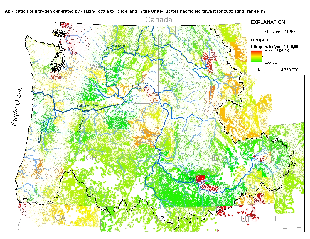
This spatial data set was created by the U.S. Geological Survey (USGS) to represent the amount of nitrogen generated by grazing cattle that was applied to range land in the Pacific Northwest region of the United States (Hydro Region 17; Major River Basin 7 (MRB7)) during 2002.
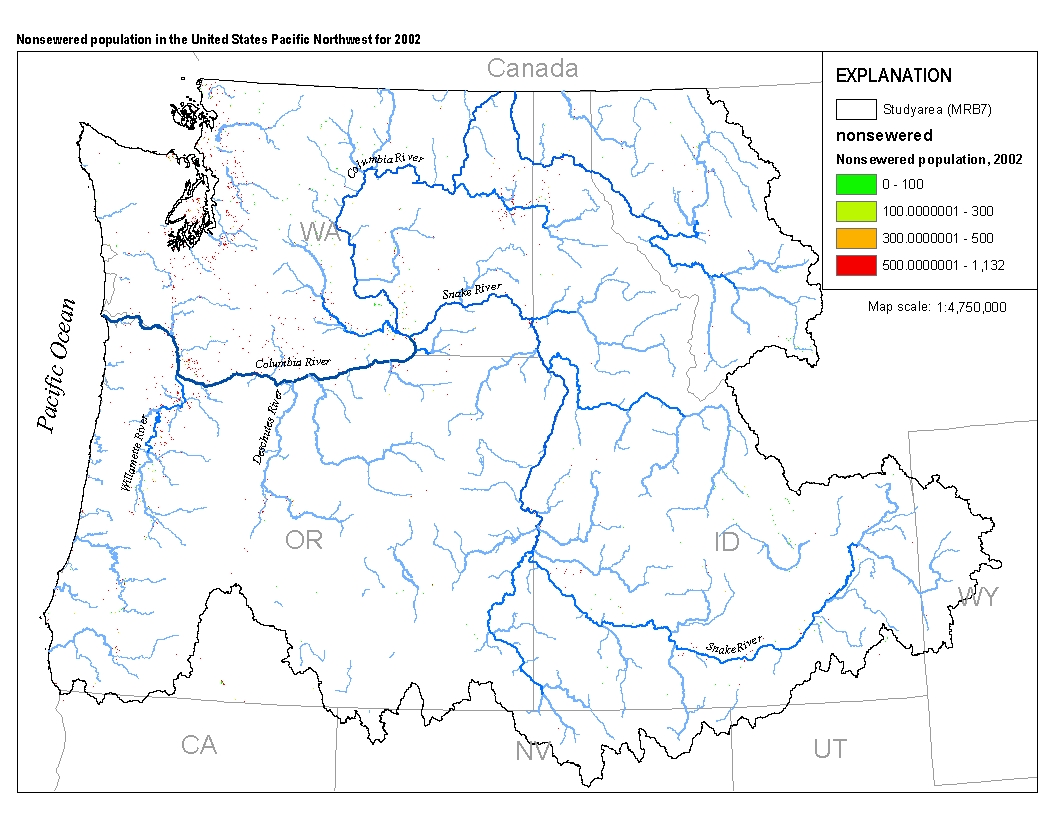
This spatial data set was created by the U.S. Geological Survey (USGS) to represent populations that did not have access to municipal sewer service in the Pacific Northwest region of the United States (Hydro Region 17; Major River Basin 7 (MRB7)) in 2002.

These data were released prior to the October 1, 2016 effective date for the USGS’s policy dictating the review, approval, and release of scientific data as referenced in USGS Survey Manual Chapter 502.8 Fundamental Science Practices: Review and Approval of Scientific Data for Release. This data set represents the average normalized atmospheric (wet) deposition, in kilograms, of Total Inorganic Nitrogen for the year 2002 compiled for every catchment of NHDPlus for the conterminous United States. Estimates of Total Inorganic Nitrogen deposition are based on National Atmospheric Deposition Program (NADP) measurements (B. Larsen, U.S. Geological Survey, written commun., 2007). De-trending methods applied to the year...

These data were released prior to the October 1, 2016 effective date for the USGS’s policy dictating the review, approval, and release of scientific data as referenced in USGS Survey Manual Chapter 502.8 Fundamental Science Practices: Review and Approval of Scientific Data for Release. This data set represents the average monthly precipitation in millimeters multiplied by 100 for 2002 compiled for every catchment of NHDPlus for the conterminous United States. The source data were the Near-Real-Time Monthly High-Resolution Precipitation Climate Data Set for the Conterminous United States (2002) raster dataset produced by the Spatial Climate Analysis Service at Oregon State University. The NHDPlus Version 1.1 is...

These data were released prior to the October 1, 2016 effective date for the USGS’s policy dictating the review, approval, and release of scientific data as referenced in USGS Survey Manual Chapter 502.8 Fundamental Science Practices: Review and Approval of Scientific Data for Release. This tabular data set represents the catchment-average total precipitation in millimeters multiplied by 100 for 2002, compiled for every MRB_E2RF1 catchment of selected Major River Basins (MRBs, Crawford and others, 2006). The source data were the Near-Real-Time Monthly High-Resolution Precipitation Climate Data Set for the Conterminous United States (2002) raster data set produced by the Spatial Climate Analysis Service at Oregon...

These data were released prior to the October 1, 2016 effective date for the USGS’s policy dictating the review, approval, and release of scientific data as referenced in USGS Survey Manual Chapter 502.8 Fundamental Science Practices: Review and Approval of Scientific Data for Release. This tabular data set represents the area of Hydrologic Landscape Regions (HLR) compiled for every MRB_E2RF1 catchment of the Major River Basins (MRBs, Crawford and others, 2006). The source data set is a 100-meter version of Hydrologic Landscape Regions of the United States (Wolock, 2003). HLR groups watersheds on the basis of similarities in land-surface form, geologic texture, and climate characteristics. The MRB_E2RF1 catchments...

These data were released prior to the October 1, 2016 effective date for the USGS’s policy dictating the review, approval, and release of scientific data as referenced in USGS Survey Manual Chapter 502.8 Fundamental Science Practices: Review and Approval of Scientific Data for Release. This spatial data set was created by the U.S. Geological Survey (USGS) to represent the extent of soils with low phosphorus retention potential in the Pacific Northwest region of the United States (Hydro Region 17; Major River Basin 7 (MRB7)).
These data were released prior to the October 1, 2016 effective date for the USGS’s policy dictating the review, approval, and release of scientific data as referenced in USGS Survey Manual Chapter 502.8 Fundamental Science Practices: Review and Approval of Scientific Data for Release. The digital segmented network based on watershed boundaries, ERF1_2, includes enhancements to the U.S. Environmental Protection Agency's River Reach File 1 (RF1) (USEPA, 1996; DeWald and others, 1985) to support national and regional-scale surface water-quality modeling. Alexander and others (1999) developed ERF1, which assessed the hydrologic integrity of the digital reach traces and calculated the mean water time-of-travel in river...

These data were released prior to the October 1, 2016 effective date for the USGS’s policy dictating the review, approval, and release of scientific data as referenced in USGS Survey Manual Chapter 502.8 Fundamental Science Practices: Review and Approval of Scientific Data for Release. This data set represents the average normalized atmospheric (wet) deposition, in kilograms, of Nitrate (NO3) for the year 2002 compiled for every catchment of NHDPlus for the conterminous United States. Estimates of NO3 deposition are based on National Atmospheric Deposition Program (NADP) measurements (B. Larsen, U.S. Geological Survey, written commun., 2007). De-trending methods applied to the year 2002 are described in Alexander...

These data were released prior to the October 1, 2016 effective date for the USGS’s policy dictating the review, approval, and release of scientific data as referenced in USGS Survey Manual Chapter 502.8 Fundamental Science Practices: Review and Approval of Scientific Data for Release. This data set represents the 30-year (1971-2000) average annual maximum temperature in Celsius multiplied by 100 compiled for every catchment of NHDPlus for the conterminous United States. The source data were the United States Average Monthly or Annual Minimum Temperature, 1971 - 2000 raster dataset produced by the PRISM Group at Oregon State University. The NHDPlus Version 1.1 is an integrated suite of application-ready geospatial...
This data release consists of the data used to develop SPAtially Referenced Regression On Watershed(SPARROW) attributes models for estimating loads of total phosphorus and total nitrogen in Tennessee streams. These data support the publication containing the Tennessee SPARROW models results (Hoos and others, 2019) and include model input used in the South Atlantic-Gulf Drainages and Tennessee River Basin (SAGT) nutrient SPARROW models (Hoos and McMahon, 2009; Garcia and others, 2011) as well as model input for river basins in Tennessee not included in the domain of the published SAGT SPARROW models. Also included in this data release are model coefficients, the software required to execute the Tennessee SPARROW...
The National Hydrography Dataset Plus, Version 2 (NHDPlusV2) is an attribute rich, digital hydrologic network for the Conterminous U.S. developed by the U.S. Environmental Protection Agency (EPA) and U.S. Geological Survey (USGS). SPAtially Referenced Regressions On Watershed attributes (SPARROW), is a process-based/statistical model that relies on a digital hydrologic network, like NHDPlusV2, in order to establish spatial relations between monitored contaminant loads, contaminant sources, and other watershed characteristics. The USGS National Water Quality Assessment (NAWQA) project adopted the medium-resolution NHDPlusV2 network as the primary framework supporting SPARROW modeling, and has become a unifying system...
Categories: Data;
Tags: Conterminous United States,
Hydrology,
NHDPlus,
SPARROW,
USGS Science Data Catalog (SDC),

Estimated phosphorus delivered to the estuaries along the Gulf of Mexico (U.S. only). Delivered load is the amount of phosphorus estimated using USGS's SPARROW model to be delivered from the upstream drainage basin to each of the estuaries draining into the Gulf of Mexico. These estimates are corrected to match monitoring load data at the most downstream monitoring site available. Units are in metric tons per year.
|

|
