Filters: Tags: SR LCC (X)
24 results (38ms)|
Filters
Date Range
Contacts Tag Schemes |

This dataset was created using the MC1 Dynamic Global Vegetation Model. It represents the mode of projected vegetation types for the time period 2041 to 2050 under the down-scaled CGCM3 Global Circulation Model under the A2 emissions scenario. The fire suppression condition was set for the model run. The spatial resolution is 30 arc seconds, and the extent is the four corners region of the southwestern USA (Utah, Colorado, Arizona and New Mexico).

This dataset was created using the MC1 Dynamic Global Vegetation Model. It represents the mode of projected vegetation types for the time period 2041 to 2050 under the down-scaled MIROC3 Global Circulation Model under the A2 emissions scenario. The fire suppression condition was set for the model run. The spatial resolution is 30 arc seconds, and the extent is the four corners region of the southwestern USA (Utah, Colorado, Arizona and New Mexico).

This dataset was created from the combination of SSURGO data. Component-level data from SSURGO were derived from the dominant component in each mapping unit (the unit that had the highest representative percent of the mapping unit). Numeric horizon-level data from SSURGO were derived from an average average across all horizons within a component, and an area-weighted average between components. This data set is a digital soil survey and generally is the most detailed level of soil geographic data developed by the National Cooperative Soil Survey. The information was prepared by digitizing maps, by compiling information onto a planimetric correct base and digitizing, or by revising digitized maps using remotely...

This dataset was created using the MC1 Dynamic Global Vegetation Model. It represents the mode of projected vegetation types for the time period 2041 to 2050 under the down-scaled CGCM3 Global Circulation Model under the B1 emissions scenario. The fire suppression condition was set for the model run. The spatial resolution is 30 arc seconds, and the extent is the four corners region of the southwestern USA (Utah, Colorado, Arizona and New Mexico).

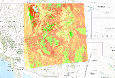
This dataset combines the sensitive soils datasets for the Southern Rockies Landscape Conservation Cooperative, the projected future vegetation and the simulated historic potential natural vegetation, created using the MC2 dynamic global vegetation model. Colors represent unique combinations of vegetation change and the number of sensitive soil factors present in a given area.

This dataset shows the number of vulnerability factors affecting the landscape in the Southern Rockies Conservation Cooperative. There can be from 0 to 9 factors (low available soil water capacity, high calcium carbonates, high gypsum content, low pH, high pH, shallow depth, high wind erodibility, high water erodibility, and high sodicity).

This rectangle encloses the area covered by the Southern Rockies Conservation Cooperative

This dataset combines the sensitive soils datasets for the Southern Rockies Landscape Conservation Cooperative, the projected future vegetation and the simulated historic potential natural vegetation, created using the MC2 dynamic global vegetation model. Colors represent unique combinations of vegetation change and the number of sensitive soil factors present in a given area.

This dataset combines the sensitive soils datasets for the Southern Rockies Landscape Conservation Cooperative, the projected future vegetation and the simulated historic potential natural vegetation, created using the MC2 dynamic global vegetation model. Colors represent unique combinations of vegetation change and the number of sensitive soil factors present in a given area.

This dataset was created using the MC1 Dynamic Global Vegetation Model. It represents the mode of projected vegetation types for the time period 2041 to 2050 under the down-scaled CSIRO Global Circulation Model under the B1 emissions scenario. The fire suppression condition was set for the model run. The spatial resolution is 30 arc seconds, and the extent is the four corners region of the southwestern USA (Utah, Colorado, Arizona and New Mexico).

This dataset combines the sensitive soils datasets for the Southern Rockies Landscape Conservation Cooperative, the projected future vegetation and the simulated historic potential natural vegetation, created using the MC2 dynamic global vegetation model. Colors represent unique combinations of vegetation change and the number of sensitive soil factors present in a given area.
This dataset combines the sensitive soils datasets for the Southern Rockies Landscape Conservation Cooperative, the projected future vegetation and the simulated historic potential natural vegetation, created using the MC2 dynamic global vegetation model. Colors represent unique combinations of vegetation change and the number of sensitive soil factors present in a given area.

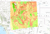
This dataset shows the number of vulnerability factors affecting the landscape in the norther portion of the Southern Rockies Conservation Cooperative. There can be from 0 to 9 factors (low available soil water capacity, high calcium carbonates, high gypsum content, low pH, high pH, shallow depth, high wind erodibility, high water erodibility, and high sodicity).
This dataset combines the sensitive soils datasets for the Southern Rockies Landscape Conservation Cooperative, the projected future vegetation and the simulated historic potential natural vegetation, created using the MC2 dynamic global vegetation model. Colors represent unique combinations of vegetation change and the number of sensitive soil factors present in a given area.

This dataset was created using the MC1 Dynamic Global Vegetation Model. It represents the mode of projected vegetation types for the time period 2041 to 2050 under the down-scaled MIROC3 Global Circulation Model under the A1B emissions scenario. The fire suppression condition was set for the model run. The spatial resolution is 30 arc seconds, and the extent is the four corners region of the southwestern USA (Utah, Colorado, Arizona and New Mexico).

This dataset was created using the MC1 Dynamic Global Vegetation Model. It represents the mode of projected vegetation types for the time period 2041 to 2050 under the down-scaled CGCM3 Global Circulation Model under the A1B emissions scenario. The fire suppression condition was set for the model run. The spatial resolution is 30 arc seconds, and the extent is the four corners region of the southwestern USA (Utah, Colorado, Arizona and New Mexico).

This dataset was created using the MC1 Dynamic Global Vegetation Model. It represents the mode of projected vegetation types for the time period 1971-2000. The fire suppression condition was set for the model run. The spatial resolution is 30 arc seconds, and the extent is the four corners region of the southwestern USA (Utah, Colorado, Arizona and New Mexico).

This dataset shows the number of vulnerability factors affecting the landscape in the southern portion of the Southern Rockies Conservation Cooperative. There can be from 0 to 9 factors (low available soil water capacity, high calcium carbonates, high gypsum content, low pH, high pH, shallow depth, high wind erodibility, high water erodibility, and high sodicity).

This dataset was created using the MC1 Dynamic Global Vegetation Model. It represents the mode of projected vegetation types for the time period 2041 to 2050 under the down-scaled CSIRO Global Circulation Model under the A2 emissions scenario. The fire suppression condition was set for the model run. The spatial resolution is 30 arc seconds, and the extent is the four corners region of the southwestern USA (Utah, Colorado, Arizona and New Mexico).

This dataset was created from the combination of SSURGO data. Component-level data from SSURGO were derived from the dominant component in each mapping unit (the unit that had the highest representative percent of the mapping unit). Numeric horizon-level data from SSURGO were derived from an average average across all horizons within a component, and an area-weighted average between components. This data set is a digital soil survey and generally is the most detailed level of soil geographic data developed by the National Cooperative Soil Survey. The information was prepared by digitizing maps, by compiling information onto a planimetric correct base and digitizing, or by revising digitized maps using remotely...
|

|
