Filters: Tags: San Gorgonio (X)
13 results (26ms)|
Filters
Date Range
Contacts
Categories Tag Types Tag Schemes |

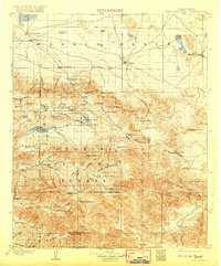
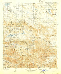
USGS Historical Quadrangle in GeoPDF.
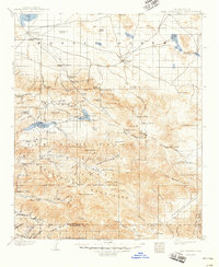
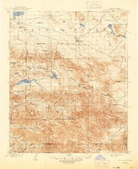
USGS Historical Quadrangle in GeoPDF.
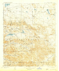
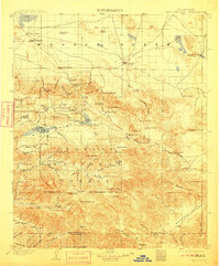
USGS Historical Quadrangle in GeoPDF.

These data were released prior to the October 1, 2016 effective date for the USGS’s policy dictating the review, approval, and release of scientific data as referenced in USGS Survey Manual Chapter 502.8 Fundamental Science Practices: Review and Approval of Scientific Data for Release. In the early 1970's, the U.S. Geological Survey (USGS) entered into a partnership with the National Aeronautic and Space Administration (NASA) to provide repetitive global images of the earth's landmasses taken from a satellite flown at an altitude of approximately 438 miles. Onboard the 1999 Landsat7 satellite, the instrument used is an 8-band multispectral scanning radiometer that produces high-resolution images of the earth using...
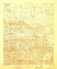
USGS Historical Quadrangle in GeoPDF.
These data were released prior to the October 1, 2016 effective date for the USGS’s policy dictating the review, approval, and release of scientific data as referenced in USGS Survey Manual Chapter 502.8 Fundamental Science Practices: Review and Approval of Scientific Data for Release. Digital Elevation Models (DEMs) are digital records of terrain elevations at regularly spaced intervals. The interval between elevations of 7.5 minute DEMs is 30-meters. Each DEM file covers the area of one U.S. Geological Survey 1 to 24,000 scale 7.5 minute topographic quadrangle.
USGS Historical Quadrangle in GeoPDF.
USGS Historical Quadrangle in GeoPDF.

These data were released prior to the October 1, 2016 effective date for the USGS’s policy dictating the review, approval, and release of scientific data as referenced in USGS Survey Manual Chapter 502.8 Fundamental Science Practices: Review and Approval of Scientific Data for Release. This Digital Raster Graphic (DRG) was created using scanned U.S. Geological Survey 7.5-minute 1 to 24,000 scale maps georeferenced in Universal Transverse Mercator (UTM) grid. DRGs can be acquired with or without collar information for use in Geographic Information System (GIS) environment. Collarless DRGs can be edge matched creating a continuous collection of topographic maps.
USGS Historical Quadrangle in GeoPDF.

These data were released prior to the October 1, 2016 effective date for the USGS’s policy dictating the review, approval, and release of scientific data as referenced in USGS Survey Manual Chapter 502.8 Fundamental Science Practices: Review and Approval of Scientific Data for Release. Digital Elevation Models (DEMs) are digital records of terrain elevations at regularly spaced intervals. The interval between elevations of 7.5 minute DEMs is 30-meters. Each DEM file covers the area of one U.S. Geological Survey 1 to 24,000 scale 7.5 minute topographic quadrangle.

These data were released prior to the October 1, 2016 effective date for the USGS’s policy dictating the review, approval, and release of scientific data as referenced in USGS Survey Manual Chapter 502.8 Fundamental Science Practices: Review and Approval of Scientific Data for Release. The hillshade image was created from raster to grid data using U.S. Geological Survey 30 meter resolution Digital Elevation Models, (DEM's).
USGS Historical Quadrangle in GeoPDF.
|

|
