Filters: Tags: Santa Cruz County (X)
639 results (130ms)|
Filters
Date Range
Extensions Types Contacts
Categories Tag Types
|
ADMMR map collection: Interpretive Geologic Cross Sections of Oro Blanco Mining District; 1 in. to 2000 feet; 22 x 17 in.
ADMMR map collection: Margarita Group, Map of Claims; 1 in. to 1000 feet; 17 x 22 in.
ADMMR map collection: Red Mountain Mine Cross Section A; 1 in. to 200 feet; 10 x 12 in.
ADMMR map collection: Glove Mine Map; 44 x 37 in.
ADMMR map collection: Bonanza - Royal Map; 1 in. to 100 feet; 11 x 9 in.
ADMMR map collection: Bonanza 226 Stope 3rd Floor; 1 in. to 40 feet; 8 x 11 in.
ADMMR map collection: Bonanza 280 INT.; 1 in. to 40 feet; 8 x 11 in.
ADMMR map collection: Black eagle, Fernando, and Salvador Mines; 1 in. to 200 feet; 35 x 24 in.
Heinrichs Geoexploration Co. Maps: World's Fair Silver Geochemical Survey; 1 in. to 200 feet; 26 x 24 in.
ADMMR map collection: Salvador Mine Map; 1 in. to 20 feet; 35 x 24 in.
Heinrichs Geoexploration Co. Maps: Austerlitz Mine, Geology Map; 1 in. to 500 feet; 33 x 31 in.
Heinrichs Geoexploration Co. Maps: S. G. Claims Area I.P. Survey; 1 in. to 300 feet; 26 x 21 in.
These data provide information about all vegetation structure measurements (except shrub point-centered quarter measures) taken on Arizona Grasshopper Sparrow nest plots in 2011 to 2013 on two study sites - Audubon Appleton-Whittell Research Ranch, and BLM Las Cienegas NCA - Davis Pasture - in southeastern Arizona.
Categories: Data;
Types: Citation;
Tags: Ammodramus savannarum ammolegus,
Arizona,
Arizona Grasshopper Sparrow,
Santa Cruz County,
United States,
ADMMR map collection: Bonanza Elayer Stope; 1 in. to 40 feet; 8 x 11 in.
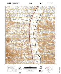
Layered geospatial PDF 7.5 Minute Quadrangle Map. Layers of geospatial data include orthoimagery, roads, grids, geographic names, elevation contours, hydrography, and other selected map features. This map is derived from GIS (geospatial information system) data. It represents a repackaging of GIS data in traditional map form, not creation of new information. The geospatial data in this map are from selected National Map data holdings and other government sources.
This part of DS 781 presents data for the sediment-thickness isopachs for the Pigeon Point to Monterey Bay, California, map region. The vector data file is included in "Isopachs_PigeonPointToMonterey.zip," which is accessible from https://doi.org/10.5066/F7N29V0Z. As part of the USGS's California State Waters Mapping Project, a 50-m-resolution grid of sediment thickness for the seafloor within the limit of California’s State Waters between Pigeon Point and southern Monterey Bay was generated from seismic-reflection data collected in 2009, 2010, and 2011 (USGS activities (S-15-10-NC, S-N1-09-MB, and S-06-11-MB) supplemented with outcrop and geologic structure from DS 781. Isopach contours at 2.5-meter intervals were...
Categories: Data;
Types: Downloadable,
Map Service,
OGC WFS Layer,
OGC WMS Layer,
Shapefile;
Tags: Ano Nuevo,
Aptos,
Distributions,
Marina,
Monterey,
This part of DS 781 presents data for the acoustic-backscatter map of Offshore of Aptos map area, California. Backscatter data are provided as two separate grids depending on mapping system and processing method. This metadata file refers to the data included in "BackscatterB_EM300_OffshoreAptos.zip," which is accessible from https://doi.org/10.5066/F7K35RQB. These data accompany the pamphlet and map sheets of Cochrane, G.R., Johnson, S.Y., Dartnell, P., Greene, H.G., Erdey, M.D, Dieter, B.E., Golden, N.E., Hartwell, S.R., Ritchie, A.C., Kvitek, r.G., Maier, K.L., Endris, C.A., Davenport, C.W., Watt, J.T., Sliter, R.W., Finlayson, D.P., and Krigsman, L.M., (G.R. Cochrane and S.A. Cochran, eds.), 2016, California...
Categories: Data;
Types: Downloadable,
GeoTIFF,
Map Service,
Raster;
Tags: Acoustic Reflectivity,
Aptos,
Backscatter,
Bathymetry,
CMHRP,
This part of DS 781 presents data for the shaded-relief bathymetry map of Offshore Santa Cruz, California. The raster data file is included in "BathymetryHS_OffshoreSantaCruz.zip", which is accessible from https://doi.org/10.5066/F7TM785G. These data accompany the pamphlet and map sheets of Cochrane, G.R., Dartnell, P., Johnson, S.Y., Erdey, M.D., Golden, N.E., Greene, H.G., Dieter, B.E., Hartwell, S.R., Ritchie, A.C., Finlayson, D.P., Endris, C.A., Watt, J.T., Davenport, C.W., Sliter, R.W., Maier, K.L., and Krigsman, L.M. (G.R. Cochrane and S.A. Cochran, eds.), 2016, California State Waters Map Series—Offshore of Santa Cruz, California: U.S. Geological Survey Open-File Report 2016-1024, pamphlet 40 p., 10 sheets,...
Categories: Data;
Types: Downloadable,
GeoTIFF,
Map Service,
Raster;
Tags: Bathymetry,
CMHRP,
Coastal and Marine Hazards and Resources Program,
Continental/Island Shelf,
Marine Nearshore Subtidal,

This part of DS 781 presents data for the shaded-relief bathymetry map of Offshore Scott Creek, California. The raster data file is included in "BathymetryHS_OffshoreScottCreek.zip", which is accessible from https://doi.org/10.5066/F7CJ8BJW. These data accompany the pamphlet and map sheets of Cochrane, G.R., Dartnell, P., Johnson, S.Y., Greene, H.G., Erdey, M.D., Dieter, B.E., Golden, N.E., Endris, C.A., Hartwell, S.R., Kvitek, R.G., Davenport, C.W., Watt, J.T., Krigsman, L.M., Ritchie, A.C., Sliter, R.W., Finlayson, D.P., and Maier, K.L. (G.R. Cochrane and S.A. Cochran, eds.), 2015, California State Waters Map Series--Offshore of Scott Creek, California: U.S. Geological Survey Open-File Report 2015-1191, pamphlet...
Categories: Data;
Types: Downloadable,
GeoTIFF,
Map Service,
Raster;
Tags: Acoustic Reflectivity,
CMHRP,
Coastal and Marine Hazards and Resources Program,
Continental/Island Shelf,
Marine Nearshore Subtidal,

This part of DS 781 presents data for the folds for the geologic and geomorphic map of the Offshore of Scott Creek map area, California. The vector data file is included in "Folds_OffshoreScottCreek.zip," which is accessible from https://doi.org/10.5066/F7CJ8BJW. These data accompany the pamphlet and map sheets of Cochrane, G.R., Dartnell, P., Johnson, S.Y., Greene, H.G., Erdey, M.D., Dieter, B.E., Golden, N.E., Endris, C.A., Hartwell, S.R., Kvitek, R.G., Davenport, C.W., Watt, J.T., Krigsman, L.M., Ritchie, A.C., Sliter, R.W., Finlayson, D.P., and Maier, K.L. (G.R. Cochrane and S.A. Cochran, eds.), 2015, California State Waters Map Series--Offshore of Scott Creek, California: U.S. Geological Survey Open-File Report...
Categories: Data;
Types: Downloadable,
Map Service,
OGC WFS Layer,
OGC WMS Layer,
Shapefile;
Tags: Bathymetry,
CMHRP,
Coastal and Marine Hazards and Resources Program,
Continental/Island Shelf,
Marine Nearshore Subtidal,
|

|
