Filters: Tags: Sea level rise (X)
339 results (27ms)|
Filters
Date Range
Extensions Types Contacts
Categories Tag Types
|
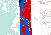
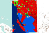
In order to predict the impacts of climate change induced sea-level rise on Pacific Northwest coastal habitats, the Sea Level Affecting Marshes Model (SLAMM) was utilized to simulate future coastal habitat configurations under various sea-level rise scenarios. The model was run for 2025, 2050, 2075, and 2100. Historical or "initial condition" habitat classifications are also available for some sites. The sea-level rise scenarios include: 1. A1B greenhouse gas emission mean : 0.39 meter rise by 2100 2. A1B greenhouse gas emission maximum : 0.69 meter rise by 2100 3. 1 meter rise by 2100 4. 1.5 meter rise by 2100 5. 2 meter rise by 2100 Due to differing site conditions, local sea-level rise varies slightly from...

In order to predict the impacts of climate change induced sea-level rise on Pacific Northwest coastal habitats, the Sea Level Affecting Marshes Model (SLAMM) was utilized to simulate future coastal habitat configurations under various sea-level rise scenarios. The model was run for 2025, 2050, 2075, and 2100. Historical or "initial condition" habitat classifications are also available for some sites. The sea-level rise scenarios include: 1. A1B greenhouse gas emission mean : 0.39 meter rise by 2100 2. A1B greenhouse gas emission maximum : 0.69 meter rise by 2100 3. 1 meter rise by 2100 4. 1.5 meter rise by 2100 5. 2 meter rise by 2100 Due to differing site conditions, local sea-level rise varies slightly from...
In order to predict the impacts of climate change induced sea-level rise on Pacific Northwest coastal habitats, the Sea Level Affecting Marshes Model (SLAMM) was utilized to simulate future coastal habitat configurations under various sea-level rise scenarios. The model was run for 2025, 2050, 2075, and 2100. Historical or "initial condition" habitat classifications are also available for some sites. The sea-level rise scenarios include: 1. A1B greenhouse gas emission mean : 0.39 meter rise by 2100 2. A1B greenhouse gas emission maximum : 0.69 meter rise by 2100 3. 1 meter rise by 2100 4. 1.5 meter rise by 2100 5. 2 meter rise by 2100 Due to differing site conditions, local sea-level rise varies slightly from...

This file includes only healthcare facilities in California which are located within the areas that would be inundated by a 100-year coastal flood. The metadata from the Heathcare Facilities shapefile is also included here. The Licensed Healthcare Facilities point layer represents the locations of all healthcare facilities licensed by the State of California, Department of Health Services (DHS), as of the publication date. Facility address information is maintained and provided by the Office of Statewide Health Planning and Development (OSHPD). Facility types include hospitals, nursing homes, clinics, etc.

This dataset provides an estimate of the lengths of levees and seawalls that would need to built or fortified to protect development along the California coast from a 100-year coastal flood event with a 1.4 meter sea-level rise.

The Base Flood Elevation, representing the elevation of the 100-year coastal flood, is derived for the entire California coastline. Elevation data is in NAVD88, rounded to the nearest half foot. Euclidean Allocation was used to extrapolate the elevations from the BFE line 10 kilometers inland from the coast. The extent of this dataset covers fthe California coast from the Oregon border south to Monterey Bay.

In order to predict the impacts of climate change induced sea-level rise on Pacific Northwest coastal habitats, the Sea Level Affecting Marshes Model (SLAMM) was utilized to simulate future coastal habitat configurations under various sea-level rise scenarios. The model was run for 2025, 2050, 2075, and 2100. Historical or "initial condition" habitat classifications are also available for some sites. The sea-level rise scenarios include: 1. A1B greenhouse gas emission mean : 0.39 meter rise by 2100 2. A1B greenhouse gas emission maximum : 0.69 meter rise by 2100 3. 1 meter rise by 2100 4. 1.5 meter rise by 2100 5. 2 meter rise by 2100 Due to differing site conditions, local sea-level rise varies slightly from...

In order to predict the impacts of climate change induced sea-level rise on Pacific Northwest coastal habitats, the Sea Level Affecting Marshes Model (SLAMM) was utilized to simulate future coastal habitat configurations under various sea-level rise scenarios. The model was run for 2025, 2050, 2075, and 2100. Historical or "initial condition" habitat classifications are also available for some sites. The sea-level rise scenarios include: 1. A1B greenhouse gas emission mean : 0.39 meter rise by 2100 2. A1B greenhouse gas emission maximum : 0.69 meter rise by 2100 3. 1 meter rise by 2100 4. 1.5 meter rise by 2100 5. 2 meter rise by 2100 Due to differing site conditions, local sea-level rise varies slightly from...

In order to predict the impacts of climate change induced sea-level rise on Pacific Northwest coastal habitats, the Sea Level Affecting Marshes Model (SLAMM) was utilized to simulate future coastal habitat configurations under various sea-level rise scenarios. The model was run for 2025, 2050, 2075, and 2100. Historical or "initial condition" habitat classifications are also available for some sites. The sea-level rise scenarios include: 1. A1B greenhouse gas emission mean : 0.39 meter rise by 2100 2. A1B greenhouse gas emission maximum : 0.69 meter rise by 2100 3. 1 meter rise by 2100 4. 1.5 meter rise by 2100 5. 2 meter rise by 2100 Due to differing site conditions, local sea-level rise varies slightly from...

This dataset shows the footprints of wastewater treatment plants (WWTP's) in the San Francisco Bay that are potentially vulnerable to a 100-year coastal flood with a 1.4 meter sea level rise.

This dataset shows police stations that are vulnerable to a 100-year coastal flood event with a 1.4 meter sea-level rise in California (year 2100 scenario). The police station data was extracted from the FEMA HAZUS model and was intersected with the flooding layers created by the Pacific Institute and USGS/SCRIPPS.

In order to predict the impacts of climate change induced sea-level rise on Pacific Northwest coastal habitats, the Sea Level Affecting Marshes Model (SLAMM) was utilized to simulate future coastal habitat configurations under various sea-level rise scenarios. The model was run for 2025, 2050, 2075, and 2100. Historical or "initial condition" habitat classifications are also available for some sites. The sea-level rise scenarios include: 1. A1B greenhouse gas emission mean : 0.39 meter rise by 2100 2. A1B greenhouse gas emission maximum : 0.69 meter rise by 2100 3. 1 meter rise by 2100 4. 1.5 meter rise by 2100 5. 2 meter rise by 2100 Due to differing site conditions, local sea-level rise varies slightly from...
Understanding how sea-level rise will affect coastal landforms and the species and habitats they support is critical for crafting approaches that balance the needs of humans and native species. Given this increasing need to forecast sea-level rise effects on barrier islands in the near and long terms, we are developing Bayesian networks to evaluate and to forecast the cascading effects of sea-level rise on shoreline change, barrier island state, and piping plover habitat availability. We use publicly available data products, such as lidar, orthophotography, and geomorphic feature sets derived from those, to extract metrics of barrier island characteristics at consistent sampling distances. The metrics are then incorporated...
Categories: Data;
Types: Downloadable,
GeoTIFF,
Map Service,
OGC WFS Layer,
OGC WMS Layer,
Raster,
Shapefile;
Tags: Assawoman Island,
Assawoman Island,
Atlantic Ocean,
Barrier Island,
Bayesian Network,
Understanding how sea-level rise will affect coastal landforms and the species and habitats they support is critical for crafting approaches that balance the needs of humans and native species. Given this increasing need to forecast sea-level rise effects on barrier islands in the near and long terms, we are developing Bayesian networks to evaluate and to forecast the cascading effects of sea-level rise on shoreline change, barrier island state, and piping plover habitat availability. We use publicly available data products, such as lidar, orthophotography, and geomorphic feature sets derived from those, to extract metrics of barrier island characteristics at consistent sampling distances. The metrics are then incorporated...
Categories: Data;
Types: Downloadable,
GeoTIFF,
Map Service,
OGC WFS Layer,
OGC WMS Layer,
Raster,
Shapefile;
Tags: Atlantic Ocean,
Barrier Island,
Bayesian Network,
CMHRP,
Coastal Erosion,
Understanding how sea-level rise will affect coastal landforms and the species and habitats they support is critical for crafting approaches that balance the needs of humans and native species. Given this increasing need to forecast sea-level rise effects on barrier islands in the near and long terms, we are developing Bayesian networks to evaluate and to forecast the cascading effects of sea-level rise on shoreline change, barrier island state, and piping plover habitat availability. We use publicly available data products, such as lidar, orthophotography, and geomorphic feature sets derived from those, to extract metrics of barrier island characteristics at consistent sampling distances. The metrics are then incorporated...
Categories: Data;
Types: Downloadable,
GeoTIFF,
Map Service,
OGC WFS Layer,
OGC WMS Layer,
Raster,
Shapefile;
Tags: Atlantic Ocean,
Barrier Island,
Bayesian Network,
CMGP,
Coastal Erosion,
The “Sea‐Level Affecting Marshes Model” (SLAMM) is a moderate resolution model used to predict the effects of sea level rise on marsh habitats (Craft et al. 2009). SLAMM has been used extensively on both the west coast (e.g., Glick et al., 2007) and east coast (e.g., Geselbracht et al., 2011) of the United States to evaluate potential changes in the distribution and extent of tidal marsh habitats. However, a limitation of the current version of SLAMM, (Version 6.2) is that it lacks the ability to model distribution changes in seagrass habitat resulting from sea level rise. Because of the ecological importance of SAV habitats, the US Environmental Protection Agency, US Geological Survey, and US Department of Agriculture...
We measured foliar δ13C of Conocarpus erectus collected from Big Pine Key in 2018 as a proxy for ground water salinity.
Categories: Data;
Tags: Big Pine Key, Florida,
Ecology,
Everglades National Park,
Forestry,
Hardwood hammock,
Spreadsheet of literature used in systematic review of sea level rise actions
Final Report: Assessing coastal manager science needs and disseminating science results for planning
In-person workshops will be conducted to bring the results from the USGS Program on Coastal Ecosystems Response to Climate Change’s study on projected climate change effects on coastal environments (funded by NPLCC and NW CSC) to managers in their communities. The workshops will include presenting initial results, identifying their climate science needs, and introducing a decision-support tool.
Categories: Data;
Types: Map Service,
OGC WFS Layer,
OGC WMS Layer,
OGC WMS Service;
Tags: Academics & scientific researchers,
CA-2,
California,
Changes in sea level and coastal storms,
Climate Change,
This project evaluates the effects of global climate change and sea level rise on estuarine intertidal habitat in the San Francisco Bay and the Pacific Flyway migratory waterbirds that rely on this habitat. Phase 2 of this project is a continuation of work to evaluate the effects of global climate change and sea level rise (SLR) on intertidal shoals in the San Francisco Bay Estuary and the migratory waterbirds that rely on this critically important resource in the Pacific Flyway. The primary objectives are to: 1) use downscaled global climate change models to translate SLR and climate scenarios into habitat quantity predictions through Delft3D and Dflow-FM (unstructured grid) geomorphic modeling; 2) model the response...
Categories: Data,
Project;
Tags: 2010,
2012,
Applications and Tools,
CA,
California Landscape Conservation Cooperative,
|

|
