Filters: Tags: Small-scale Datasets - Contours (X)
14 results (14ms)|
Filters
Date Range
Extensions Types Contacts
Categories Tag Types Tag Schemes
|

This map layer shows elevation contour lines for Hawaii. The map layer was derived from the 100-meter resolution elevation data set which is published by the National Atlas of the United States, and is in the same Albers Equal-area Conic projection as that source data set. Contour intervals match the steps used in the National Atlas Color-Sliced Elevation data sets. Contours were adjusted so that they are in the proper relationship to National Atlas 1:1,000,000-scale lakes, reservoirs, and wide (double-line) streams.

This map layer shows elevation contour lines for Alaska. The map layer was derived from the 100-meter resolution elevation data set which is published by the National Atlas of the United States, and is in the same Albers Equal-area Conic projection as that source data set. Contour intervals match the steps used in the National Atlas Color-Sliced Elevation data sets. Contours were adjusted so that they are in the proper relationship to National Atlas 1:1,000,000-scale lakes, reservoirs, and wide (double-line) streams.
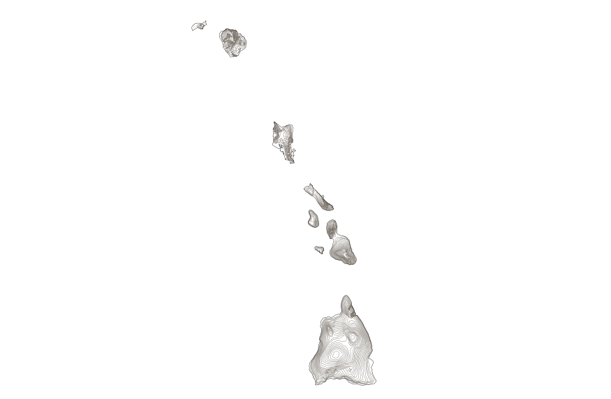
This map layer shows elevation contour lines for Hawaii. The map layer was derived from the 100-meter resolution elevation data set which is published by the National Atlas of the United States, and is in the same Albers Equal-area Conic projection as that source data set. Contour intervals match the steps used in the National Atlas Color-Sliced Elevation data sets. Contours were adjusted so that they are in the proper relationship to National Atlas 1:1,000,000-scale lakes, reservoirs, and wide (double-line) streams.
This dataset is a polyline shapefile containing bathymetric contours, at 1-meter intervals, of Lago Guayabal, Villalba, Puerto Rico. The contours were generated from bathymetric data collected during a sedimentation survey conducted during the period December 11- December 14, 2017 by the Puerto Rico office of the Caribbean-Florida Water Science Center of the U.S. Geological Survey (USGS). The goals of the survey were to determine reservoir infill sedimentation rates, generate a bathymetric map of the reservoir, and create a stage-volume relation. Field techniques used during the survey were similar to those outlined by Soler-López (2008) and Wilson and Richards (2006). More than 270,000 water-depth points were surveyed...
Categories: Data;
Types: Downloadable,
Map Service,
OGC WFS Layer,
OGC WMS Layer,
Shapefile;
Tags: Bathymetry and Elevation,
GNIS ID 1611313,
Geographic Names Informaion System,
Juana Diaz County,
Lago Guayabal,
This data release contains spatial data associated with the bathymetric survey and sedimentation analysis of Lago Carite in January 2018. During January 23–30, 2018, the U.S. Geological Survey, in cooperation with the Puerto Rico Electric Power Authority, conducted a bathymetric survey of Lago Carite primarily to update estimates of the contemporary reservoir storage capacity and sedimentation rate. Previously designated transect lines were surveyed by using a depth sounder coupled to a differential geographic positioning system to generate a bottom contour map and, ultimately, the stage-storage relation for Lago Carite. This data release consisted of three items: bathymetric contours, water-depth data points and...

This map layer shows elevation contour lines for the conterminous United States. The map layer was derived from the 100-meter resolution elevation data set which is published by the National Atlas of the United States, and is in the same Albers Equal-area Conic projection as that source data set. Contour intervals match the steps used in the National Atlas Color-Sliced Elevation data sets. Contours were adjusted so that they are in the proper relationship to National Atlas 1:1,000,000-scale lakes, reservoirs, and wide (double-line) streams.
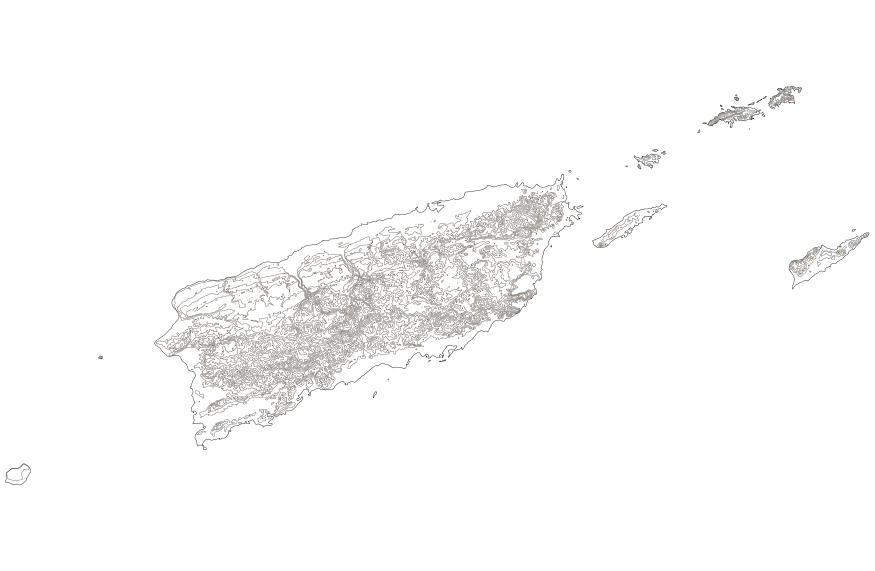
This map layer shows elevation contour lines for Puerto Rico and the U.S. Virgin Islands. The map layer was derived from the 100-meter resolution elevation data set which is published by the National Atlas of the United States, and is in the same Albers Equal-area Conic projection as that source data set. Contour intervals match the steps used in the National Atlas Color-Sliced Elevation data sets. Contours were adjusted so that they are in the proper relationship to National Atlas 1:1,000,000-scale lakes, reservoirs, and wide (double-line) streams.
This dataset is a polygon shapefile containing reservoir boundary of Lago Guayabal, and represents the contour at the spillway elevation. This polygon was used to constraint the extent of the Triangulated irregular network (TIN) model and ultimately, to generate contours from bathymetric data collected during a sedimentation survey conducted during the period December 11- December 14, 2017 by the Puerto Rico office of the Caribbean-Florida Water Science Center of the U.S. Geological Survey (USGS). The goals of the survey were to determine reservoir infill sedimentation rates, generate a bathymetric map of the reservoir, and create a stage-volume relation. Field techniques used during the survey were similar to those...
Categories: Data;
Types: Downloadable,
Map Service,
OGC WFS Layer,
OGC WMS Layer,
Shapefile;
Tags: Bathymetry and Elevation,
GNIS ID 1611313,
Geographic Names Informaion System,
Juana Diaz County,
Lago Guayabal,

This map layer shows elevation contour lines for the conterminous United States. The map layer was derived from the 100-meter resolution elevation data set which is published by the National Atlas of the United States, and is in the same Albers Equal-area Conic projection as that source data set. Contour intervals match the steps used in the National Atlas Color-Sliced Elevation data sets. Contours were adjusted so that they are in the proper relationship to National Atlas 1:1,000,000-scale lakes, reservoirs, and wide (double-line) streams.
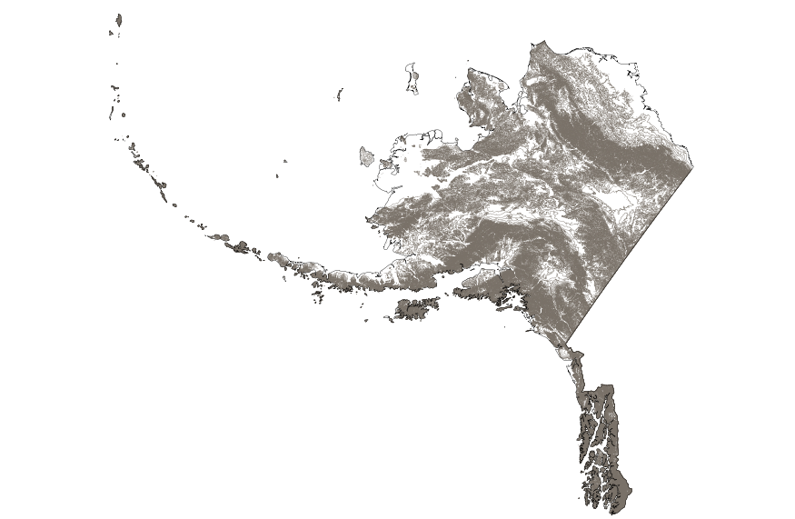
This map layer shows elevation contour lines for Alaska. The map layer was derived from the 100-meter resolution elevation data set which is published by the National Atlas of the United States, and is in the same Albers Equal-area Conic projection as that source data set. Contour intervals match the steps used in the National Atlas Color-Sliced Elevation data sets. Contours were adjusted so that they are in the proper relationship to National Atlas 1:1,000,000-scale lakes, reservoirs, and wide (double-line) streams.
This dataset is a polygon shapefile containing the reservoir shoreline for the sedimentation survey of Lago Carite, Puerto Rico.This polygon was used to constraint the extent of the Triangulated irregular network (TIN) model and ultimately, to generate contours from bathymetric data collected during the period January 23 - January 30, 2018 by the Puerto Rico office of the Caribbean-Florida Water Science Center of the U.S. Geological Survey (USGS). The goals of the survey were to determine reservoir infill sedimentation rates, generate a bathymetric map of the reservoir, and create a stage-volume relation. Field techniques used during the survey were similar to those outlined by Soler-López and Carrasquillo-Nieves,...

This map layer shows elevation contour lines for Puerto Rico and the U.S. Virgin Islands. The map layer was derived from the 100-meter resolution elevation data set which is published by the National Atlas of the United States, and is in the same Albers Equal-area Conic projection as that source data set. Contour intervals match the steps used in the National Atlas Color-Sliced Elevation data sets. Contours were adjusted so that they are in the proper relationship to National Atlas 1:1,000,000-scale lakes, reservoirs, and wide (double-line) streams.
This dataset is a polyline shapefile containing bathymetric contours, at 1-meter intervals, of Lago Carite, Puerto Rico. The contours were generated from bathymetric data collected during a sedimentation survey conducted during the period January 23 - January 30, 2018 by the Puerto Rico office of the Caribbean-Florida Water Science Center of the U.S. Geological Survey (USGS). The goals of the survey were to determine reservoir infill sedimentation rates, generate a bathymetric map of the reservoir, and create a stage-volume relation. Field techniques used during the survey were similar to those outlined by Soler-López and Carrasquillo-Nieves, (2001) and Wilson and Richards (2006).A total of 137 planned transect...
This dataset is a point shapefile containing water-depth points collected during a sedimentation survey of Lago Carite, Puerto Rico. The contours were generated from bathymetric data collected during a sedimentation survey conducted during the period January 23 - January 30, 2018 by the Puerto Rico office of the Caribbean-Florida Water Science Center of the U.S. Geological Survey (USGS). The goals of the survey were to determine reservoir infill sedimentation rates, generate a bathymetric map of the reservoir, and create a stage-volume relation. Field techniques used during the survey were similar to those outlined by Soler-López and Carrasquillo-Nieves, (2001) and Wilson and Richards (2006). A total of 137 planned...
|

|
