Filters: Tags: Socioeconomics (X) > partyWithName: Conservation Biology Institute (X)
3 results (14ms)|
Filters
Date Range
Tag Schemes |

These data area an extraction of the "dominant" non-extractive/recreational data from the Northern Hawaii Ocean Uses Atlas. For the full dataset please visit, http://www.mpa.gov/dataanalysis/hi_coastal_use/ The Hawaii Coastal Use Mapping Project is an innovative partnership between NOAA's National Marine Protected Areas Center, NOAA's Pacific Islands Regional Office (PIRO), the Hawaii Division of Aquatic Resources (DAR), and NOAA's Pacific Islands Fisheries Science Center . The project was designed to enhance ocean management by gathering geospatial data on human uses of the nearshore ocean environment in the Kawaihae-Keahole region of Hawaii Island. It has provided an unprecedented, comprehensive, consistent...

These data area an extraction of the "dominant" extractive data from the Northern Hawaii Ocean Uses Atlas. For the full dataset please visit, http://www.mpa.gov/dataanalysis/hi_coastal_use/ The Hawaii Coastal Use Mapping Project is an innovative partnership between NOAA's National Marine Protected Areas Center, NOAA's Pacific Islands Regional Office (PIRO), the Hawaii Division of Aquatic Resources (DAR), and NOAA's Pacific Islands Fisheries Science Center . The project was designed to enhance ocean management by gathering geospatial data on human uses of the nearshore ocean environment in the Kawaihae-Keahole region of Hawaii Island. It has provided an unprecedented, comprehensive, consistent and spatially explicit...
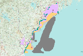
These data area an extraction of the "dominant" non-consumptive data from the New Hampshire and Southern Maine Ocean Uses Atlas. For the full dataset please visit, http://www.mpa.gov/dataanalysis/atlas_nhsm/. The New Hampshire and Southern Maine Ocean Uses Atlas Project is an innovative partnership between NOAA's Marine Protected Areas Center and the University of New Hampshire’s Coastal Response Resource Center CRCC. Inspired by and used in the March 2010 Spill of National Significance drill (SONS 2010 ), the Atlas project fills a critical information gap in response efforts and ocean management by mapping, for the first time, the full range of significant human uses of the ocean in state and federal waters off...
|

|
