Filters: Tags: Socioeconomics (X)
5 results (44ms)|
Filters
Date Range
Extensions (Less) Types (Less) Contacts (Less)
Categories (Less) Tag Types
|

These data area an extraction of the "dominant" non-extractive/recreational data from the Northern Hawaii Ocean Uses Atlas. For the full dataset please visit, http://www.mpa.gov/dataanalysis/hi_coastal_use/ The Hawaii Coastal Use Mapping Project is an innovative partnership between NOAA's National Marine Protected Areas Center, NOAA's Pacific Islands Regional Office (PIRO), the Hawaii Division of Aquatic Resources (DAR), and NOAA's Pacific Islands Fisheries Science Center . The project was designed to enhance ocean management by gathering geospatial data on human uses of the nearshore ocean environment in the Kawaihae-Keahole region of Hawaii Island. It has provided an unprecedented, comprehensive, consistent...
The twenty-first century is likely to witness increased levels of weather-related disasters, droughts, epidemics, food shortages, habitat destruction, and resource conflicts. Those environmental and systemic problems will be mediated and exacerbated by potential economic dislocations, including job losses, financial crises, and commodity-price increases. As a result, the problem of resilience will increasingly permeate the politics and policies of sustainability transitions. Using a comparative analysis of two American households located at opposited ends of the income pyramid, this article explores the issue of how to think about the relationship between sustainable consumption and resilience. Although the two...
Categories: Publication;
Types: Citation;
Tags: environmental impact,
households,
income,
socioeconomics

These data area an extraction of the "dominant" extractive data from the Northern Hawaii Ocean Uses Atlas. For the full dataset please visit, http://www.mpa.gov/dataanalysis/hi_coastal_use/ The Hawaii Coastal Use Mapping Project is an innovative partnership between NOAA's National Marine Protected Areas Center, NOAA's Pacific Islands Regional Office (PIRO), the Hawaii Division of Aquatic Resources (DAR), and NOAA's Pacific Islands Fisheries Science Center . The project was designed to enhance ocean management by gathering geospatial data on human uses of the nearshore ocean environment in the Kawaihae-Keahole region of Hawaii Island. It has provided an unprecedented, comprehensive, consistent and spatially explicit...
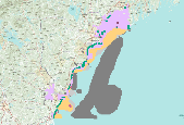
These data area an extraction of the "dominant" non-consumptive data from the New Hampshire and Southern Maine Ocean Uses Atlas. For the full dataset please visit, http://www.mpa.gov/dataanalysis/atlas_nhsm/. The New Hampshire and Southern Maine Ocean Uses Atlas Project is an innovative partnership between NOAA's Marine Protected Areas Center and the University of New Hampshire’s Coastal Response Resource Center CRCC. Inspired by and used in the March 2010 Spill of National Significance drill (SONS 2010 ), the Atlas project fills a critical information gap in response efforts and ocean management by mapping, for the first time, the full range of significant human uses of the ocean in state and federal waters off...
Urban communities are increasingly shaping the conservation future of the South Atlantic. Major metropolitan areas present both direct threats, such as loss habitat and open space, and indirect threats, such as creating barriers to connectivity. As a result of both these direct and indirect threats, and their scale, metropolitan areas pose a challenge when thinking about corridors and connectivity, and many of the traditional approaches to green infrastructure and conservation are not adequate for urban areas. The Conservation Blueprint (Blueprint) is cross-boundary, cross-organization plan that prioritizes areas for shared conservation action in the South Atlantic. It is designed as a resource for conservation...
Categories: Data,
Project;
Types: Map Service,
OGC WFS Layer,
OGC WMS Layer,
OGC WMS Service;
Tags: 2016,
2017,
2018,
ANTHROPOGENIC/HUMAN INFLUENCED ECOSYSTEMS,
AQUATIC ECOSYSTEMS,
|

|
