Filters: Tags: Subregion (X) > Categories: Data (X)
5 results (79ms)|
Filters
Date Range
Extensions Types Contacts
Tag Types Tag Schemes |

The Watershed Boundary Dataset (WBD) from The National Map (TNM) defines the perimeter of drainage areas formed by the terrain and other landscape characteristics. The drainage areas are nested within each other so that a large drainage area, such as the Upper Mississippi River, will be composed of multiple smaller drainage areas, such as the Wisconsin River. Each of these smaller areas can further be subdivided into smaller and smaller drainage areas. The WBD uses six different levels in this hierarchy, with the smallest averaging about 30,000 acres. The WBD is made up of polygons nested into six levels of data respectively defined by Regions, Subregions, Basins, Subbasins, Watersheds, and Subwatersheds. For additional...
The Cape Fear and Pee Dee River Basins in North Carolina and South Carolina were chosen as a focus area study (FAS) for the U.S. Geological Survey (USGS) National Water Census (NWC) in 2016. The objective of the NWC is to place technical information and tools in the hands of stake holders so that they can make decisions on water availability. The USGS South Atlantic Water Science Center, comprised of North Carolina, South Carolina, and Georgia, conducted a 3-year study of water use and availability to provide information related to the competing societal and ecological water needs in the Southeastern Atlantic Coastal Basins of the Carolinas. One task to meet this objective was compiling water withdrawal and return...
In 1998, the Florida Fish and Wildlife Conservation Commission's (FWC) Fisheries Independent Monitoring (FIM) program began a long-term monitoring effort of key reef fish populations in the Florida Keys National Marine Sanctuary. This effort was aimed at evaluating the relative abundance, size structure, and habitat utilization of specific reef fish species that are targeted by commercial and recreational fisheries.; Smith,S.G., et al. 2011,Multispecies survey design for assessing reef-fish stocks, spatially explicit management performance, and ecosystem condition. Fisheries Research 109(2011)25-41; Brandt,M.E., et. al. 2009,A Cooperative Multi-agency Reef Fish Monitoring Protocol for the Florida Keys Coral Reef...
Categories: Data;
Types: NetCDF OPeNDAP Service;
Tags: Atmosphere > Air Quality > Visibility,
Dry Tortugas Reef Visual Census 2016,
absence,
air,
aphia,
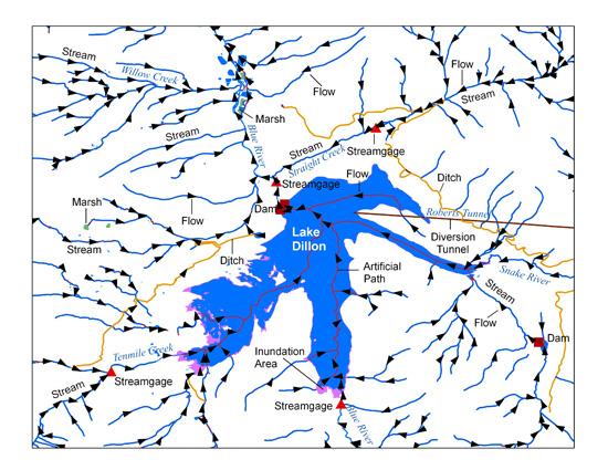
The USGS National Hydrography Dataset (NHD) is a comprehensive set of digital spatial data that encodes information about naturally occurring and constructed bodies of surface water (lakes, ponds, and reservoirs), paths through which water flows (canals, ditches, streams, and rivers), and related entities such as point features (springs, wells, stream gages, and dams). The information encoded about these features includes classification and other characteristics, delineation, geographic name, position and related measures, a "reach code" through which other information can be related to the NHD, and the direction of water flow. The network of reach codes delineating water and transported material flow allows users...
Categories: Data;
Tags: Administrative watershed units,
Area of Complex Channels,
Area to be submerged,
Aroostook County,
Artificial path,

The USGS National Hydrography Dataset (NHD) service from The National Map (TNM) is a comprehensive set of digital spatial data that encodes information about naturally occurring and constructed bodies of surface water (lakes, ponds, and reservoirs), paths through which water flows (canals, ditches, streams, and rivers), and related entities such as point features (springs, wells, stream gages, and dams). The information encoded about these features includes classification and other characteristics, delineation, geographic name, position and related measures, a "reach code" through which other information can be related to the NHD, and the direction of water flow. The network of reach codes delineating water and...
Categories: Data;
Types: ArcGIS REST Map Service,
Map Service;
Tags: HU,
Hydrography,
NGP-TNM,
NHD,
Overlay Map Service,
|

|