Filters: Tags: TIFF (X)
1,195 results (1.4s)|
Filters
Date Range
Extensions Types Contacts
Categories Tag Types
|
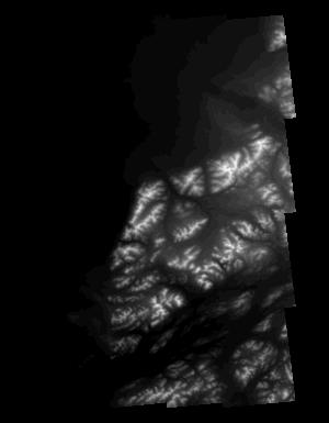
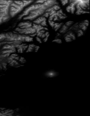
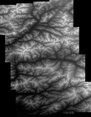
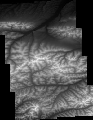
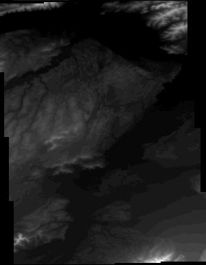
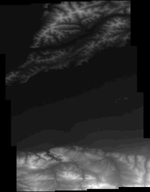
These data are Digital Surface Models (DSM) derived from interferometric synthetic aperture radar (ifsar) data. A DSM is a 3 dimensional representation of surface elevations in an area, including elevations of man-made structures and vegetation. The USGS performs minimal quality assurance and no reprocessing of the DSM data. USGS distributes the DSM data as received from the contractors, partners or contributing entities.
Types: Citation;
Tags: Cartography,
DSM,
Digital Mapping,
Digital Surface Model,
Digital Terrain Model,

Aerial Photograph, AL_AP200232, of Wythe Co. is part of the New Jersey Zinc Company Historic Collection ; topic area is 'Aerial Photograph'. The location is Wythe Co. (estimated). The image was scanned from a paper file as part of the USGS NGGDPP deliverable for 2018-2019. The author is United States Department of Agriculture. The scale is . The paper file was dated 19531003. Physical Storage: Room 3, Austinville Limestone Company, Newtown Church Rd, Austinville, VA 24312, Room No: 3. Digital Storage: \\NG00222222\ARCHIVE\Collections\NewJerseyZinc\AERIALPHOTOS\AL_AP200232.TIF Additional Information: None

Aerial Photograph, AL_AP200239, of Wythe Co. is part of the New Jersey Zinc Company Historic Collection ; topic area is 'Aerial Photograph'. The location is Wythe Co. (estimated). The image was scanned from a paper file as part of the USGS NGGDPP deliverable for 2018-2019. The author is United States Department of Agriculture. The scale is 1''=660'. The paper file was dated 19380103. Physical Storage: Room 3, Austinville Limestone Company, Newtown Church Rd, Austinville, VA 24312, Room No: 3. Digital Storage: \\NG00222222\ARCHIVE\Collections\NewJerseyZinc\AERIALPHOTOS\AL_AP200239.TIF Additional Information: None

Aerial Photograph Index, AL_AP200339, of Wythe Co. is part of the New Jersey Zinc Company Historic Collection ; topic area is 'Aerial Photograph Index'. The location is Wythe Co. (estimated). The image was scanned from a paper file as part of the USGS NGGDPP deliverable for 2018-2019. The author is United States Department of Agriculture, Agricultrual Stablization and Conservation Service (USGS ASCS). The scale is 1''=40000'. The paper file was dated 19741006. Physical Storage: Room 3 ,Austinville Limestone Company, Newtown Church Rd, Austinville, VA 24312, Room No: 3. Digital Storage: \\NG00222222\ARCHIVE\Collections\NewJerseyZinc\AERIALPHOTOS\AL_AP200339.TIF Additional Information: Sheet 3/5

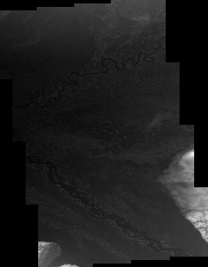
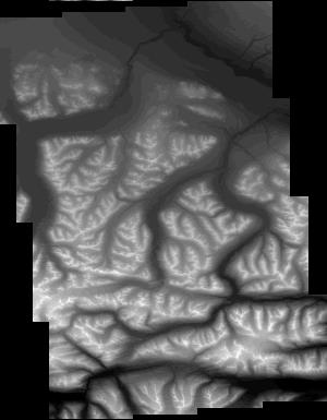
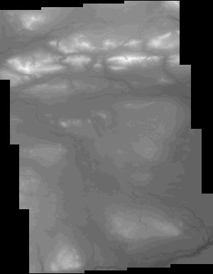
These data are orthorectified radar intensity images (ORI) derived from interferometric synthetic aperture radar (ifsar) data. An ORI is a high-resolution image derived from ifsar which has geometric distortions removed. Unlike optical imagery, ifsar can be collected in cloudy conditions. The USGS performs minimal quality assurance and no reprocessing of the ORI data. USGS distributes the ORI data as received from the contractors, partners or contributing entities.

Aerial Photograph, AL_AP200037, of Wythe Co. is part of the New Jersey Zinc Company Historic Collection ; topic area is 'Aerial Photograph'. The location is Wythe Co. (estimated). The image was scanned from a paper file as part of the USGS NGGDPP deliverable for 2018-2019. The author is United States Department of Agriculture. The scale is 1''=300'. The paper file was dated 19540210. Physical Storage: Room 3, Austinville Limestone Company, Newtown Church Rd, Austinville, VA 24312, Room No: 3. Digital Storage: \\NG00222222\ARCHIVE\Collections\NewJerseyZinc\AERIALPHOTOS\AL_AP200037.TIF Additional Information: These are just general photos taken over Austinville; I need to figure out their organization. Some are unlabeled

Aerial Photograph, AL_AP200053, of Montgomery Co. is part of the New Jersey Zinc Company Historic Collection ; topic area is 'Aerial Photograph'. The location is Montgomery Co. (estimated). The image was scanned from a paper file as part of the USGS NGGDPP deliverable for 2018-2019. The author is United States Department of Agriculture. The scale is 1''=2000'. The paper file was dated 19621022. Physical Storage: Room 3, Austinville Limestone Company, Newtown Church Rd, Austinville, VA 24312, Room No: 3. Digital Storage: \\NG00222222\ARCHIVE\Collections\NewJerseyZinc\AERIALPHOTOS\AL_AP200053.TIF Additional Information: None
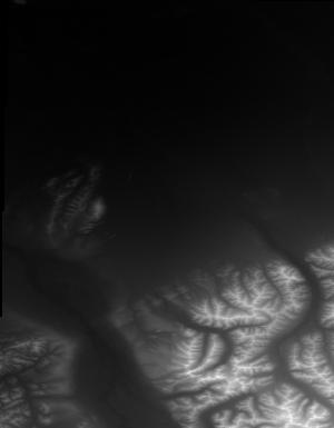
These data are Digital Surface Models (DSM) derived from interferometric synthetic aperture radar (ifsar) data. A DSM is a 3 dimensional representation of surface elevations in an area, including elevations of man-made structures and vegetation. The USGS performs minimal quality assurance and no reprocessing of the DSM data. USGS distributes the DSM data as received from the contractors, partners or contributing entities.
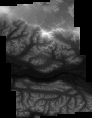
These data are Digital Surface Models (DSM) derived from interferometric synthetic aperture radar (ifsar) data. A DSM is a 3 dimensional representation of surface elevations in an area, including elevations of man-made structures and vegetation. The USGS performs minimal quality assurance and no reprocessing of the DSM data. USGS distributes the DSM data as received from the contractors, partners or contributing entities.
These data are Digital Surface Models (DSM) derived from interferometric synthetic aperture radar (ifsar) data. A DSM is a 3 dimensional representation of surface elevations in an area, including elevations of man-made structures and vegetation. The USGS performs minimal quality assurance and no reprocessing of the DSM data. USGS distributes the DSM data as received from the contractors, partners or contributing entities.
These data are Digital Surface Models (DSM) derived from interferometric synthetic aperture radar (ifsar) data. A DSM is a 3 dimensional representation of surface elevations in an area, including elevations of man-made structures and vegetation. The USGS performs minimal quality assurance and no reprocessing of the DSM data. USGS distributes the DSM data as received from the contractors, partners or contributing entities.

These data are orthorectified radar intensity images (ORI) derived from interferometric synthetic aperture radar (ifsar) data. An ORI is a high-resolution image derived from ifsar which has geometric distortions removed. Unlike optical imagery, ifsar can be collected in cloudy conditions. The USGS performs minimal quality assurance and no reprocessing of the ORI data. USGS distributes the ORI data as received from the contractors, partners or contributing entities.

Aerial Photograph, AL_AP200205, of Wythe Co. is part of the New Jersey Zinc Company Historic Collection ; topic area is 'Aerial Photograph'. The location is Wythe Co. (estimated). The image was scanned from a paper file as part of the USGS NGGDPP deliverable for 2018-2019. The author is United States Department of Agriculture. The scale is 1''=700. The paper file was dated 19621011. Physical Storage: Room 3, Austinville Limestone Company, Newtown Church Rd, Austinville, VA 24312, Room No: 3. Digital Storage: \\NG00222222\ARCHIVE\Collections\NewJerseyZinc\AERIALPHOTOS\AL_AP200205.TIF Additional Information: None
These data are Digital Surface Models (DSM) derived from interferometric synthetic aperture radar (ifsar) data. A DSM is a 3 dimensional representation of surface elevations in an area, including elevations of man-made structures and vegetation. The USGS performs minimal quality assurance and no reprocessing of the DSM data. USGS distributes the DSM data as received from the contractors, partners or contributing entities.

These data are Digital Surface Models (DSM) derived from interferometric synthetic aperture radar (ifsar) data. A DSM is a 3 dimensional representation of surface elevations in an area, including elevations of man-made structures and vegetation. The USGS performs minimal quality assurance and no reprocessing of the DSM data. USGS distributes the DSM data as received from the contractors, partners or contributing entities.
Types: Citation;
Tags: Cartography,
DSM,
Digital Mapping,
Digital Surface Model,
Digital Terrain Model,
|

|
