Filters: Tags: USFWS (X)
124 results (13ms)|
Filters
Date Range
Extensions (Less)
Types (Less)
Contacts (Less)
Categories (Less) Tag Types
|

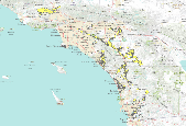
These data identify, in general, the areas where final critical habitat for Castilleja cinerea (Ash-gray Indian paintbrush) occur.

These data identify, in general, the areas where final critical habitat for Erigeron parishii (Parish's daisy) occur.
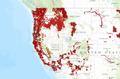
This is a web map service from the USFWS. It contains multiple layers related to final critical habitat for threatened and endangered species. Critical habitat are areas considered essential for the conservation of a listed species. These datasets include both line and polygon features.More information can be found here: http://criticalhabitat.fws.gov/crithab/

These data identify, in general, the areas where final critical habitat for the Coachella Valley fringe-toed lizard (Uma inornata) occur.
These data identify, in general, the areas where final critical habitat for the coastal California gnatcatcher (Polioptila californica californica) occur.
Location of burrowing owl boxes at Shinohara property, Sweetwater Reservoir, San Diego National Wildlife Refuge, San Diego County, CA. Data provided by John Martin, Biologist, USFWS.

The intent of this data is to identify watersheds where Region 4 Fisheries Program work should be focused. Â Additional on-the-ground assessments may be necessary to verify conditions. Â The Fisheries Program proposes to work across Programs and with partners to identify conservation needs within the selected watersheds, and identify joint efforts and projects to leverage resources to maximize efficiency. These actions may include such projects as habitat improvements, barrier removal, propagation, and genetic conservation.
Soils data clipped to the Clear Lake NWR boundary. These are SSURGO soils from the USDA, Natural Resources Conservation Service.
Categories: Data;
Types: ArcGIS REST Map Service,
ArcGIS Service Definition,
Downloadable,
Map Service,
OGC WFS Layer,
OGC WMS Layer,
Shapefile;
Tags: California,
Clear Lake NWR,
usfws
This data set represents the extent, approximate location and type of wetlands and deepwater habitats in the United States and its Territories. These data delineate the areal extent of wetlands and surface waters as defined by Cowardin et al. (1979). Certain wetland habitats are excluded from the National mapping program because of the limitations of aerial imagery as the primary data source used to detect wetlands. These habitats include seagrasses or submerged aquatic vegetation that are found in the intertidal and subtidal zones of estuaries and near shore coastal waters. Some deepwater reef communities (coral or tuberficid worm reefs) have also been excluded from the inventory. These habitats, because of their...
Categories: Data;
Types: Map Service,
OGC WFS Layer,
OGC WMS Layer,
OGC WMS Service;
Tags: Academics & scientific researchers,
Alabama,
Alabama,
Alaska,
Arizona,
The Hydrology Point Feature Class defines natural/semi natual point hydrographic features (springs, seeps, tanks, guzzlers…) on RSL. The data for this point feature class was provided by the refuge.
Categories: Data;
Types: ArcGIS REST Map Service,
ArcGIS Service Definition,
Citation,
Downloadable,
Map Service,
OGC WFS Layer,
OGC WMS Layer,
Shapefile;
Tags: Hydrology,
Nevada,
Ruby Lake NWR,
Water,
basins,
This is the SSURGO soils data from the USDA, NRCS, clipped to the boundary of Bear Valley NWR. Some of the attributes are included in this dataset, but not the entire database which is available from the NRCS. For full metadata, see this site: http://www.nrcs.usda.gov/wps/portal/nrcs/detail/tx/home/?cid=nrcs142p2_053631
Categories: Data;
Types: ArcGIS REST Map Service,
ArcGIS Service Definition,
Downloadable,
Map Service,
OGC WFS Layer,
OGC WMS Layer,
Shapefile;
Tags: Bear Valley NWR,
Oregon (OR),
SSURGO,
Soils,
USFWS
This dataset depicts 10 foot contours derived from the USGS 1/3 arc second (10m) digital elevation model.
Categories: Data;
Types: ArcGIS REST Map Service,
ArcGIS Service Definition,
Citation,
Downloadable,
Map Service,
OGC WFS Layer,
OGC WMS Layer,
Shapefile;
Tags: Klamath Marsh NWR,
Oregon (OR),
USFWS,
contours,
elevation,
Wildfire and fuel treatment locations for the USFWS Pacific Southwest Region (California, Nevada, Klamath Basin OR) extracted from the Fire Management Information System (FMIS) on October 23, 2015, for fiscal years 1980-2015.
Categories: Data;
Types: ArcGIS REST Map Service,
ArcGIS Service Definition,
Citation,
Downloadable,
Map Service;
Tags: California,
Inventory and Monitoring,
Natural Resources,
Nevada,
Oregon,
The purpose of this dataset is to display the physical boundaries of Fire Management Zones within the U.S. Fish & Wildlife Service, Pacific Southwest Region.
Categories: Data;
Types: ArcGIS REST Map Service,
ArcGIS Service Definition,
Citation,
Downloadable,
Map Service;
Tags: California,
Nevada,
Oregon,
Wildlife Refuge,
boundaries,

These data identify, in general, the areas where final critical habitat for the San Diego fairy shrimp (Branchinecta sandiegonensis) occur.

These data identify, in general, the areas where final critical habitat for the Mountain Yellow-legged frog (Rana muscosa) occur.

These data identify, in general, the areas where final critical habitat for ACANTHAMINTHA ILICIFOLIA (SAN DIEGO THORNMINT) occur.
Contours generated from 10m National Elevation Dataset and clipped to the boundary of Modoc National Wildlife Refuge.
Categories: Data;
Types: ArcGIS REST Map Service,
ArcGIS Service Definition,
Citation,
Downloadable,
Map Service,
OGC WFS Layer,
OGC WMS Layer,
Shapefile;
Tags: California (CA),
Modoc NWR,
USFWS,
contours,
terrain
Boundaries of Landscape Conservation Cooperatives participating in the Multi-LCC Mississippi River Basin/Gulf Hypoxia Initiative.
Categories: Data;
Types: ArcGIS REST Map Service,
ArcGIS Service Definition,
Downloadable,
Map Service;
Tags: LCC,
USFWS,
agriculture,
birds,
conservation,
SLAMM-View is a web browser-based application that provides tools for improved understanding of results from research projects that employ the Sea Level Affecting Marshes Model (SLAMM). Version 2.0 of SLAMM-View was designed for a user-friendly, workflow-based approach to assess impacts of sea-level rise (SLR) on coastal areas with both visualization and analysis functionality. SLAMM-View provides simultaneous comparison between both current and future conditions out to the year 2100, and among different SLR scenarios (e.g., 0.4 meter vs. 1 meter), using interactive maps and tabular reporting capabilities. To date, SLAMM-View provides access to SLAMM simulation results for the entire coastlines of 5 states, and...
|

|
