Filters: Tags: Utuado (X)
126 results (3.6s)|
Filters
Date Range
Extensions Types
Contacts
Categories Tag Types Tag Schemes
|

An orthoimage is remotely sensed image data in which displacement of features in the image caused by terrain relief and sensor orientation have been mathematically removed. Orthoimagery combines the image characteristics of a photograph with the geometric qualities of a map. There is no image overlap between adjacent files. Data received at Earth Resources Observation and Science Center (EROS) were reprojected from: Projection: NAD_1983_StatePlane_Puerto_Rico_Virgin_Islands_FIPS_5200 Resolution: 0.3000m Type: 4 Band to: Standard Product Projection: NAD_1983_UTM_Zone_19N Standard Product Resolution: 0.3000 m Rows: 5000 Columns: 5000 and resampled to align to the U.S. National Grid (USNG) using The National Map. The...
Types: Citation;
Tags: 0.3 meter orthoimage,
010,
1500 x 1500 meter,
4 Band orthophoto,
Downloadable Data,

An orthoimage is remotely sensed image data in which displacement of features in the image caused by terrain relief and sensor orientation have been mathematically removed. Orthoimagery combines the image characteristics of a photograph with the geometric qualities of a map. There is no image overlap between adjacent files. Data received at Earth Resources Observation and Science Center (EROS) were reprojected from: Projection: NAD_1983_StatePlane_Puerto_Rico_Virgin_Islands_FIPS_5200 Resolution: 0.3048 m Type: Natural Color to: Standard Product Projection: NAD_1983_UTM_Zone_19N Standard Product Resolution: 0.3000 m Rows: 5,000 Columns: 5,000 and resampled to align to the U.S. National Grid (USNG). The naming convention...

An orthoimage is remotely sensed image data in which displacement of features in the image caused by terrain relief and sensor orientation have been mathematically removed. Orthoimagery combines the image characteristics of a photograph with the geometric qualities of a map. There is no image overlap between adjacent files. Data received at Earth Resources Observation and Science Center (EROS) were reprojected from: Projection: NAD_1983_StatePlane_Puerto_Rico_Virgin_Islands_FIPS_5200 Resolution: 0.3048 m Type: Natural Color to: Standard Product Projection: NAD_1983_UTM_Zone_19N Standard Product Resolution: 0.3000 m Rows: 5,000 Columns: 5,000 and resampled to align to the U.S. National Grid (USNG). The naming convention...
The U.S. Geological Survey, in cooperation with the Puerto Rico Department of Natural and Environmental Resources, completed a study to determine whether a relation exists between the extent of forest cover and the magnitude of base flow at two sets of paired drainage basins in the highlands of the municipalities of Adjuntas and Utuado within the mountainous interior of Puerto Rico. One set of paired basins includes the Río Guaónica and Río Tanamá, both tributaries of the Río Grande de Arecibo. The other set includes two smaller basins in the drainage basin of the Río Coabey, which is a tributary of the Río Tanamá. The paired basins in each set have similar rainfall patterns, geologic substrate, and aspect; the...

This data represents the map extent for current and historical USGS topographic maps for the United States and Territories, including 1 X 2 Degree, 1 X 1 Degree, 30 X 60 Minute, 15 X 15 Minute, 7.5 X 7.5 Minute, and 3.75 X 3.75 Minute. The grid was generated using ESRI ArcInfo GIS software.

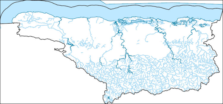
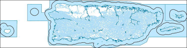
The National Hydrography Dataset (NHD) is a feature-based database that interconnects and uniquely identifies the stream segments or reaches that make up the nation's surface water drainage system. NHD data was originally developed at 1:100,000-scale and exists at that scale for the whole country. This high-resolution NHD, generally developed at 1:24,000/1:12,000 scale, adds detail to the original 1:100,000-scale NHD. (Data for Alaska, Puerto Rico and the Virgin Islands was developed at high-resolution, not 1:100,000 scale.) Local resolution NHD is being developed where partners and data exist. The NHD contains reach codes for networked features, flow direction, names, and centerline representations for areal water...
The National Hydrography Dataset (NHD) is a feature-based database that interconnects and uniquely identifies the stream segments or reaches that make up the nation's surface water drainage system. NHD data was originally developed at 1:100,000-scale and exists at that scale for the whole country. This high-resolution NHD, generally developed at 1:24,000/1:12,000 scale, adds detail to the original 1:100,000-scale NHD. (Data for Alaska, Puerto Rico and the Virgin Islands was developed at high-resolution, not 1:100,000 scale.) Local resolution NHD is being developed where partners and data exist. The NHD contains reach codes for networked features, flow direction, names, and centerline representations for areal water...
This dataset comprises a vector shapefile of the Puerto Rico geologic map from Bawiec et al. (1999), clipped to study areas in the Lares, Utuado, and Naranjito municipalities, with a modified basal contact of the Tertiary Lares Limestone (Tla) re-mapped using a lidar-derived digital elevation model (DEM) (USGS, 2018). The limestone unit of interest forms a prominent break in slope with the underlying geologic units, and this break in slope was mapped as the Tla basal contact. Only the southern contact of the Tla unit was modified. References: Bawiec, W.J., ed., 1999, Geology, geochemistry, geophysics, mineral occurrences and mineral resource assessment for the Commonwealth of Puerto Rico: U.S. Geological Survey...
Categories: Data;
Types: Downloadable,
Map Service,
OGC WFS Layer,
OGC WMS Layer,
Shapefile;
Tags: Geomorphology,
Puerto Rico,
Stratigraphy,
Structural Geology,
USGS Science Data Catalog (SDC),
The data include soil texture, soil-water, and estimated soil strength properties for soil map units and from geotechnical investigations of landslide areas affecting highways in the municipalities of Lares, Naranjito, and Utuado, Puerto Rico. The map units are derived from published soil mapping (https://websoilsurvey.sc.egov.usda.gov/app/) and have been grouped by municipality, Unified Soil Classification System symbol, and order-of-magnitude ranges of hydraulic conductivity to create generalized map units for assigning soil-water parameters and soil-strength parameters. Each group (generalized unit) includes one or more soil map units. The groups are numbered sequentially from one (1) for each municipality with...
The National Hydrography Dataset (NHD) is a feature-based database that interconnects and uniquely identifies the stream segments or reaches that make up the nation's surface water drainage system. NHD data was originally developed at 1:100,000-scale and exists at that scale for the whole country. This high-resolution NHD, generally developed at 1:24,000/1:12,000 scale, adds detail to the original 1:100,000-scale NHD. (Data for Alaska, Puerto Rico and the Virgin Islands was developed at high-resolution, not 1:100,000 scale.) Local resolution NHD is being developed where partners and data exist. The NHD contains reach codes for networked features, flow direction, names, and centerline representations for areal water...

An orthoimage is remotely sensed image data in which displacement of features in the image caused by terrain relief and sensor orientation have been mathematically removed. Orthoimagery combines the image characteristics of a photograph with the geometric qualities of a map. There is no image overlap between adjacent files. Data received at Earth Resources Observation and Science Center (EROS) were reprojected from: Projection: NAD_1983_StatePlane_Puerto_Rico_Virgin_Islands_FIPS_5200 Resolution: 0.3048 m Type: Natural Color to: Standard Product Projection: NAD_1983_UTM_Zone_19N Standard Product Resolution: 0.3000 m Rows: 5,000 Columns: 5,000 and resampled to align to the U.S. National Grid (USNG). The naming convention...

An orthoimage is remotely sensed image data in which displacement of features in the image caused by terrain relief and sensor orientation have been mathematically removed. Orthoimagery combines the image characteristics of a photograph with the geometric qualities of a map. There is no image overlap between adjacent files. Data received at Earth Resources Observation and Science Center (EROS) were reprojected from: Projection: NAD_1983_StatePlane_Puerto_Rico_Virgin_Islands_FIPS_5200 Resolution: 0.3048 m Type: Natural Color to: Standard Product Projection: NAD_1983_UTM_Zone_19N Standard Product Resolution: 0.3000 m Rows: 5,000 Columns: 5,000 and resampled to align to the U.S. National Grid (USNG). The naming convention...

An orthoimage is remotely sensed image data in which displacement of features in the image caused by terrain relief and sensor orientation have been mathematically removed. Orthoimagery combines the image characteristics of a photograph with the geometric qualities of a map. There is no image overlap between adjacent files. Data received at Earth Resources Observation and Science Center (EROS) were reprojected from: Projection: NAD_1983_StatePlane_Puerto_Rico_Virgin_Islands_FIPS_5200 Resolution: 0.3000m Type: 4 Band to: Standard Product Projection: NAD_1983_UTM_Zone_19N Standard Product Resolution: 0.3000 m Rows: 5000 Columns: 5000 and resampled to align to the U.S. National Grid (USNG) using The National Map. The...
Types: Citation;
Tags: 0.3 meter orthoimage,
010,
1500 x 1500 meter,
4 Band orthophoto,
Downloadable Data,
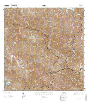
Layered GeoPDF Quadrangle Map. Layers of geospatial data include orthoimagery, roads, grids, geographic names, elevation contours, hydrography, and other selected map features.
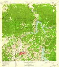
USGS Historical Quadrangle in GeoPDF.
|

|
