Filters: Tags: Water - Inland (X)
12 results (24ms)|
Filters
Date Range
Extensions Types
Contacts
Categories Tag Types Tag Schemes |

The Watershed Boundary Dataset (WBD) from The National Map (TNM) defines the perimeter of drainage areas formed by the terrain and other landscape characteristics. The drainage areas are nested within each other so that a large drainage area, such as the Upper Mississippi River, will be composed of multiple smaller drainage areas, such as the Wisconsin River. Each of these smaller areas can further be subdivided into smaller and smaller drainage areas. The WBD uses six different levels in this hierarchy, with the smallest averaging about 30,000 acres. The WBD is made up of polygons nested into six levels of data respectively defined by Regions, Subregions, Basins, Subbasins, Watersheds, and Subwatersheds. For additional...

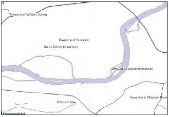
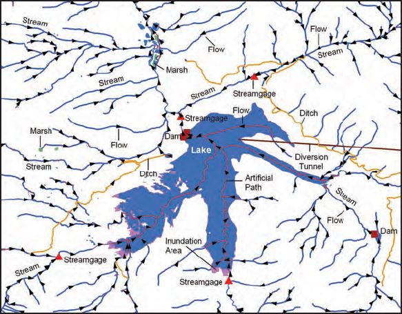
The USGS National Hydrography Dataset (NHD) service from The National Map (TNM) is a comprehensive set of digital spatial data that encodes information about naturally occurring and constructed bodies of surface water (lakes, ponds, and reservoirs), paths through which water flows (canals, ditches, streams, and rivers), and related entities such as point features (springs, wells, stream gages, and dams). The information encoded about these features includes classification and other characteristics, delineation, geographic name, position and related measures, a "reach code" through which other information can be related to the NHD, and the direction of water flow. The network of reach codes delineating water and...
The USGS Topo Large service from The National Map (TNM) is a dynamic topographic base map service that combines the best available data (Boundaries, Elevation, Geographic Names, Hydrography, Land Cover, Structures, Transportation, and other themes) that make up The National Map. Contours generated for the US Topo product are visible along with other data at scales of 1:13,500 and larger. This product is designed to provide a seamless view of the data in a geographic information system (GIS) accessible format, closely resembling The National Map US Topo GeoPDF product at large scales.

USGS Imagery Topo is a topographic tile cache base map with orthoimagery as a backdrop, and combines the most current data (Boundaries, Names, Transportation, Elevation, Hydrography, and other themes) that make up The National Map. Contours generated for the US Topo product are included and are visible along with other data to the 1:18,000 zoom scale. This product is designed to provide a seamless view of the data, closely resembling The National Map's US Topo (GeoPDF) product at large scales, in a GIS accessible format. Orthoimagery data are typically high resolution aerial images that combine the visual attributes of an aerial photograph with the spatial accuracy and reliability of a map. Digital orthoimage resolution...

U.S. Geological Survey, Department of the Interior - The annual Watershed Boundary Dataset (WBD) stewardship plan is to maintain watershed boundary data through usage of WBD edit tools over the United States and its territories. WBD for the nation has been collected and is now in maintenance mode. Interested parties who wish to become a stewardship partner with the USGS in FY15 or in future years should contact a USGS Geospatial Liaison - http://liaisons.usgs.gov/geospatial/documents/TNM_Partnership_User_ContactList.pdf. To find out more about watershed boundary stewardship go to http://nhd.usgs.gov/wbd.html or http://nhd.usgs.gov/WBDstewardshipInfoSheet.pdf
Abstract To aid in parameterization of mechanistic, statistical, and machine learning models of hydrologic systems in the contiguous United States (CONUS), flow-conditioned parameter grids (FCPGs) have been generated describing upstream basin mean elevation, slope, land cover class, latitude, and 30-year climatologies of mean total annual precipitation, minimum daily air temperature, and maximum daily air temperature. Additional datasets of upstream basin area and binary stream presence-absence are provided to help validate queries against the flow-conditioned data. These data are provided as virtual raster tile (vrt) mosaics of cloud optimized GeoTIFFs to allow point queries of the data (see Distribution Information)...
Categories: Data;
Types: ArcGIS REST Map Service,
ArcGIS Service Definition,
Downloadable,
Map Service,
OGC WFS Layer,
OGC WMS Layer,
OGC WMS Service;
Tags: CPG,
Daymet,
FCPG,
Flow-Conditioned Parameter Grids,
Hydrologic,
U.S. Geological Survey, Department of the Interior - The annual Geographic Names acquisition plan is to collect geographic name data over the United States and its territories through the Board on Geographic Names processes. The U.S. Board on Geographic Names is a Federal body created in 1890 and established in its present form by Public Law in 1947 to maintain uniform geographic name usage throughout the Federal Government. The Board comprises representatives of Federal agencies concerned with geographic information, population, ecology, and management of public lands. Sharing its responsibilities with the Secretary of the Interior, the Board promulgates official geographic feature names with locative attributes...

U.S. Geological Survey, Department of the Interior - The annual US Topo acquisition plan is to collect topographic map data in the form of US Topo GeoPDF maps over the United States and its territories on a 3-year revision cycle. The FY14 acquisition plan currently anticipates production of 18,500 (or more) US Topo maps this year. Interested parties who wish to become a data acquisition partner with the USGS in FY14 or in future years should contact a USGS Geospatial Liaison - http://liaisons.usgs.gov/geospatial/documents/TNM_Partnership_User_ContactList.pdf.
U.S. Geological Survey, Department of the Interior - The annual National Hydrography Dataset (NHD) stewardship plan is to maintain hydrography data in the NHD over the United States and its territories. NHD for the nation has been collected and is now in maintenance mode. Interested parties who wish to become a NHD stewardship partner with the USGS in FY15 or in future years should contact a USGS Geospatial Liaison - http://liaisons.usgs.gov/geospatial/documents/TNM_Partnership_User_ContactList.pdf. To find out more about hydrography stewardship go to http://nhd.usgs.gov/stewardship.html or for exact project status information on areas currently in work go to http://nhd.usgs.gov/project_status.html
The USGS National Hydrography Dataset (NHD) service from The National Map (TNM) is a comprehensive set of digital spatial data that encodes information about naturally occurring and constructed bodies of surface water (lakes, ponds, and reservoirs), paths through which water flows (canals, ditches, streams, and rivers), and related entities such as point features (springs, wells, stream gages, and dams). The information encoded about these features includes classification and other characteristics, delineation, geographic name, position and related measures, a "reach code" through which other information can be related to the NHD, and the direction of water flow. The network of reach codes delineating water and...
Categories: Data;
Types: ArcGIS REST Map Service,
Map Service;
Tags: HU,
Hydrography,
NGP-TNM,
NHD,
Overlay Map Service,
USGS Topo is a topographic tile cache base map that combines the most current data (Boundaries, Names, Transportation, Elevation, Hydrography, Land Cover, and other themes) that make up The National Map. Contours generated for the US Topo product are included and are visible along with other data to the 1:18,000 zoom scale. This product is designed to provide a seamless view of the data, closely resembling The National Map's US Topo (GeoPDF) product at large scales, in a GIS accessible format.
USGS Hydro-NHD is a tile cache base map that combines hydrography data in The National Map from the National Hydrography Dataset (NHD) along with the Watershed Boundary Dataset (WBD). The NHD is a comprehensive set of digital spatial data that encodes information about naturally occurring and constructed bodies of surface water (lakes, ponds, and reservoirs), paths through which water flows (canals, ditches, streams, and rivers), and related entities such as point features (springs, wells, stream gages, and dams). The information encoded about these features includes classification and other characteristics, delineation, geographic name, position and related measures, a "reach code" through which other information...
|

|
