Filters
Date Range
Contacts
Tag Types
Tag Schemes
|

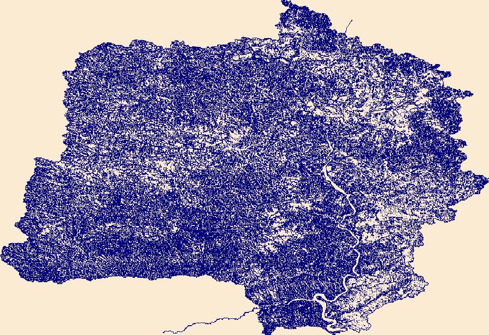
The High Resolution National Hydrography Dataset Plus (NHDPlus HR) is an integrated set of geospatial data layers, including the best available National Hydrography Dataset (NHD), the 10-meter 3D Elevation Program Digital Elevation Model (3DEP DEM), and the National Watershed Boundary Dataset (WBD). The NHDPlus HR combines the NHD, 3DEP DEMs, and WBD to create a stream network with linear referencing, feature naming, "value added attributes" (VAAs), elevation-derived catchments, and other features for hydrologic data analysis. The stream network with linear referencing is a system of data relationships applied to hydrographic systems so that one stream reach "flows" into another and "events" can be tied to and traced...
Tags: AK,
Alaska,
Anchorage County,
Downloadable Data,
FileGDB, All tags...
FileGDB 10.1,
HU-8 Subbasin,
HU-8 Subbasin,
HU8_19020401,
Hydrography,
Kenai Peninsula County,
Matanuska-Susitna County,
NHDPlus HR Rasters,
NHDPlus High Resolution (NHDPlus HR),
National Hydrography Dataset (NHD),
National Hydrography Dataset Plus High Resolution (NHDPlus HR),
National Hydrography Dataset Plus High Resolution (NHDPlus HR) Current,
US,
United States,
base maps,
cartography,
catchments,
channels,
digital elevation models,
drainage basins,
earth sciences,
elevation,
environment,
geographic information systems,
geoscientific,
geospatial analysis,
hydrographic datasets,
hydrographic features,
hydrology,
imagery,
inland waters,
lakes,
land surface characteristics,
reservoirs,
river reaches,
rivers,
streamflow,
streamflow data,
streams,
topography,
water bodies,
water quality,
water resources,
watersheds, Fewer tags

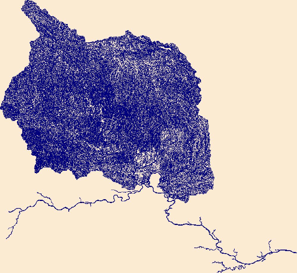
The High Resolution National Hydrography Dataset Plus (NHDPlus HR) is an integrated set of geospatial data layers, including the best available National Hydrography Dataset (NHD), the 10-meter 3D Elevation Program Digital Elevation Model (3DEP DEM), and the National Watershed Boundary Dataset (WBD). The NHDPlus HR combines the NHD, 3DEP DEMs, and WBD to create a stream network with linear referencing, feature naming, "value added attributes" (VAAs), elevation-derived catchments, and other features for hydrologic data analysis. The stream network with linear referencing is a system of data relationships applied to hydrographic systems so that one stream reach "flows" into another and "events" can be tied to and traced...
Tags: CharlotteCounty,
CitrusCounty,
DeSotoCounty,
Downloadable Data,
FL, All tags...
FileGDB,
FileGDB 10.1,
Florida,
GladesCounty,
HU-4 Subregion,
HU-4 Subregion,
HardeeCounty,
HernandoCounty,
HighlandsCounty,
HillsboroughCounty,
Hydrography,
LakeCounty,
LeeCounty,
LevyCounty,
ManateeCounty,
MarionCounty,
NHDPlus HR Rasters,
NHDPlus High Resolution (NHDPlus HR),
National Hydrography Dataset (NHD),
National Hydrography Dataset Plus High Resolution (NHDPlus HR),
National Hydrography Dataset Plus High Resolution (NHDPlus HR) Current,
PascoCounty,
PinellasCounty,
PolkCounty,
SarasotaCounty,
SumterCounty,
US,
United States,
base maps,
cartography,
catchments,
channels,
digital elevation models,
drainage basins,
earth sciences,
elevation,
environment,
geographic information systems,
geoscientific,
geospatial analysis,
hydrographic datasets,
hydrographic features,
hydrology,
imagery,
inland waters,
lakes,
land surface characteristics,
reservoirs,
river reaches,
rivers,
streamflow,
streamflow data,
streams,
topography,
water bodies,
water quality,
water resources,
watersheds, Fewer tags

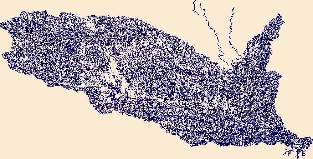
The High Resolution National Hydrography Dataset Plus (NHDPlus HR) is an integrated set of geospatial data layers, including the best available National Hydrography Dataset (NHD), the 10-meter 3D Elevation Program Digital Elevation Model (3DEP DEM), and the National Watershed Boundary Dataset (WBD). The NHDPlus HR combines the NHD, 3DEP DEMs, and WBD to create a stream network with linear referencing, feature naming, "value added attributes" (VAAs), elevation-derived catchments, and other features for hydrologic data analysis. The stream network with linear referencing is a system of data relationships applied to hydrographic systems so that one stream reach "flows" into another and "events" can be tied to and traced...
Tags: Archer County,
Baylor County,
Beckham County,
Briscoe County,
Bryan County, All tags...
Caddo County,
Canadian County,
Carter County,
Childress County,
Clay County,
Collingsworth County,
Comanche County,
Cooke County,
Cottle County,
Cotton County,
Crosby County,
Custer County,
Dewey County,
Dickens County,
Downloadable Data,
FileGDB,
FileGDB 10.1,
Floyd County,
Foard County,
Garvin County,
Grady County,
Gray County,
Grayson County,
HU-4 Subregion,
HU-4 Subregion,
HU4_1113,
Hale County,
Hall County,
Hardeman County,
Harmon County,
Hemphill County,
Hydrography,
Jackson County,
Jefferson County,
Johnston County,
King County,
Kiowa County,
Knox County,
Love County,
Marshall County,
McClain County,
Montague County,
Motley County,
Murray County,
NHDPlus HR Rasters,
NHDPlus High Resolution (NHDPlus HR),
National Hydrography Dataset (NHD),
National Hydrography Dataset Plus High Resolution (NHDPlus HR),
National Hydrography Dataset Plus High Resolution (NHDPlus HR) Current,
OK,
Oklahoma,
Pontotoc County,
Roberts County,
Roger Mills County,
Stephens County,
Swisher County,
TX,
Texas,
Tillman County,
US,
United States,
Washita County,
Wheeler County,
Wichita County,
Wilbarger County,
Young County,
base maps,
cartography,
catchments,
channels,
digital elevation models,
drainage basins,
earth sciences,
elevation,
environment,
geographic information systems,
geoscientific,
geospatial analysis,
hydrographic datasets,
hydrographic features,
hydrology,
imagery,
inland waters,
lakes,
land surface characteristics,
reservoirs,
river reaches,
rivers,
streamflow,
streamflow data,
streams,
topography,
water bodies,
water quality,
water resources,
watersheds, Fewer tags

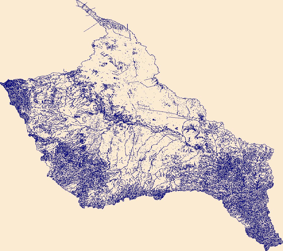
The High Resolution National Hydrography Dataset Plus (NHDPlus HR) is an integrated set of geospatial data layers, including the best available National Hydrography Dataset (NHD), the 10-meter 3D Elevation Program Digital Elevation Model (3DEP DEM), and the National Watershed Boundary Dataset (WBD). The NHDPlus HR combines the NHD, 3DEP DEMs, and WBD to create a stream network with linear referencing, feature naming, "value added attributes" (VAAs), elevation-derived catchments, and other features for hydrologic data analysis. The stream network with linear referencing is a system of data relationships applied to hydrographic systems so that one stream reach "flows" into another and "events" can be tied to and traced...
Tags: Chaves County,
Culberson County,
Curry County,
De Baca County,
Downloadable Data, All tags...
Eddy County,
FileGDB,
FileGDB 10.1,
Guadalupe County,
HU-4 Subregion,
HU-4 Subregion,
HU4_1306,
Hydrography,
Lea County,
Lincoln County,
Mora County,
NHDPlus HR Rasters,
NHDPlus High Resolution (NHDPlus HR),
NM,
National Hydrography Dataset (NHD),
National Hydrography Dataset Plus High Resolution (NHDPlus HR),
National Hydrography Dataset Plus High Resolution (NHDPlus HR) Current,
New Mexico,
Otero County,
Quay County,
Rio Arriba County,
Roosevelt County,
San Miguel County,
Santa Fe County,
TX,
Texas,
Torrance County,
US,
United States,
base maps,
cartography,
catchments,
channels,
digital elevation models,
drainage basins,
earth sciences,
elevation,
environment,
geographic information systems,
geoscientific,
geospatial analysis,
hydrographic datasets,
hydrographic features,
hydrology,
imagery,
inland waters,
lakes,
land surface characteristics,
reservoirs,
river reaches,
rivers,
streamflow,
streamflow data,
streams,
topography,
water bodies,
water quality,
water resources,
watersheds, Fewer tags

The High Resolution National Hydrography Dataset Plus (NHDPlus HR) is an integrated set of geospatial data layers, including the best available National Hydrography Dataset (NHD), the 10-meter 3D Elevation Program Digital Elevation Model (3DEP DEM), and the National Watershed Boundary Dataset (WBD). The NHDPlus HR combines the NHD, 3DEP DEMs, and WBD to create a stream network with linear referencing, feature naming, "value added attributes" (VAAs), elevation-derived catchments, and other features for hydrologic data analysis. The stream network with linear referencing is a system of data relationships applied to hydrographic systems so that one stream reach "flows" into another and "events" can be tied to and traced...
Tags: Adams County,
Benton County,
Chelan County,
Douglas County,
Downloadable Data, All tags...
Ferry County,
FileGDB,
FileGDB 10.1,
Franklin County,
Grant County,
HU-4 Subregion,
HU-4 Subregion,
HU4_1702,
Hydrography,
King County,
Kittitas County,
Lincoln County,
NHDPlus HR Rasters,
NHDPlus High Resolution (NHDPlus HR),
National Hydrography Dataset (NHD),
National Hydrography Dataset Plus High Resolution (NHDPlus HR),
National Hydrography Dataset Plus High Resolution (NHDPlus HR) Current,
Okanogan County,
Pend Oreille County,
Skagit County,
Snohomish County,
Spokane County,
Stevens County,
US,
United States,
WA,
Walla Walla County,
Washington,
Whatcom County,
Yakima County,
base maps,
cartography,
catchments,
channels,
digital elevation models,
drainage basins,
earth sciences,
elevation,
environment,
geographic information systems,
geoscientific,
geospatial analysis,
hydrographic datasets,
hydrographic features,
hydrology,
imagery,
inland waters,
lakes,
land surface characteristics,
reservoirs,
river reaches,
rivers,
streamflow,
streamflow data,
streams,
topography,
water bodies,
water quality,
water resources,
watersheds, Fewer tags

The High Resolution National Hydrography Dataset Plus (NHDPlus HR) is an integrated set of geospatial data layers, including the best available National Hydrography Dataset (NHD), the 10-meter 3D Elevation Program Digital Elevation Model (3DEP DEM), and the National Watershed Boundary Dataset (WBD). The NHDPlus HR combines the NHD, 3DEP DEMs, and WBD to create a stream network with linear referencing, feature naming, "value added attributes" (VAAs), elevation-derived catchments, and other features for hydrologic data analysis. The stream network with linear referencing is a system of data relationships applied to hydrographic systems so that one stream reach "flows" into another and "events" can be tied to and traced...
Tags: Adjuntas County,
Aguada County,
Aguadilla County,
Aguas Buenas County,
Aibonito County, All tags...
Arecibo County,
Arroyo County,
Añasco County,
Barceloneta County,
Barranquitas County,
Bayamón County,
Cabo Rojo County,
Caguas County,
Camuy County,
Canóvanas County,
Carolina County,
Cataño County,
Cayey County,
Ceiba County,
Ciales County,
Cidra County,
Coamo County,
Comerío County,
Corozal County,
Culebra County,
Dorado County,
Downloadable Data,
Fajardo County,
FileGDB,
FileGDB 10.1,
Florida County,
Guayama County,
Guayanilla County,
Guaynabo County,
Gurabo County,
Guánica County,
HU-4 Subregion,
HU-4 Subregion,
HU4_2101,
Hatillo County,
Hormigueros County,
Humacao County,
Hydrography,
Isabela County,
Jayuya County,
Juana Díaz County,
Juncos County,
Lajas County,
Lares County,
Las Marías County,
Las Piedras County,
Loíza County,
Luquillo County,
Manatí County,
Maricao County,
Maunabo County,
Mayagüez County,
Moca County,
Morovis County,
NHDPlus HR Rasters,
NHDPlus High Resolution (NHDPlus HR),
Naguabo County,
Naranjito County,
National Hydrography Dataset (NHD),
National Hydrography Dataset Plus High Resolution (NHDPlus HR),
National Hydrography Dataset Plus High Resolution (NHDPlus HR) Current,
Orocovis County,
PR,
Patillas County,
Peñuelas County,
Ponce County,
Puerto Rico,
Quebradillas County,
Rincón County,
Río Grande County,
Sabana Grande County,
Salinas County,
San Germán County,
San Juan County,
San Lorenzo County,
San Sebastián County,
Santa Isabel County,
Toa Alta County,
Toa Baja County,
Trujillo Alto County,
US,
United States,
Utuado County,
Vega Alta County,
Vega Baja County,
Vieques County,
Villalba County,
Yabucoa County,
Yauco County,
base maps,
cartography,
catchments,
channels,
digital elevation models,
drainage basins,
earth sciences,
elevation,
environment,
geographic information systems,
geoscientific,
geospatial analysis,
hydrographic datasets,
hydrographic features,
hydrology,
imagery,
inland waters,
lakes,
land surface characteristics,
reservoirs,
river reaches,
rivers,
streamflow,
streamflow data,
streams,
topography,
water bodies,
water quality,
water resources,
watersheds, Fewer tags

The High Resolution National Hydrography Dataset Plus (NHDPlus HR) is an integrated set of geospatial data layers, including the best available National Hydrography Dataset (NHD), the 10-meter 3D Elevation Program Digital Elevation Model (3DEP DEM), and the National Watershed Boundary Dataset (WBD). The NHDPlus HR combines the NHD, 3DEP DEMs, and WBD to create a stream network with linear referencing, feature naming, "value added attributes" (VAAs), elevation-derived catchments, and other features for hydrologic data analysis. The stream network with linear referencing is a system of data relationships applied to hydrographic systems so that one stream reach "flows" into another and "events" can be tied to and traced...
Tags: Allegany County,
Cattaraugus County,
Downloadable Data,
FileGDB,
FileGDB 10.1, All tags...
Genesee County,
HU-4 Subregion,
HU-4 Subregion,
HU4_0413,
Hydrography,
Livingston County,
Monroe County,
NHDPlus HR Rasters,
NHDPlus High Resolution (NHDPlus HR),
NY,
National Hydrography Dataset (NHD),
National Hydrography Dataset Plus High Resolution (NHDPlus HR),
National Hydrography Dataset Plus High Resolution (NHDPlus HR) Current,
New York,
Niagara County,
Ontario County,
Orleans County,
PA,
Pennsylvania,
Potter County,
Steuben County,
US,
United States,
Wyoming County,
base maps,
cartography,
catchments,
channels,
digital elevation models,
drainage basins,
earth sciences,
elevation,
environment,
geographic information systems,
geoscientific,
geospatial analysis,
hydrographic datasets,
hydrographic features,
hydrology,
imagery,
inland waters,
lakes,
land surface characteristics,
reservoirs,
river reaches,
rivers,
streamflow,
streamflow data,
streams,
topography,
water bodies,
water quality,
water resources,
watersheds, Fewer tags

The High Resolution National Hydrography Dataset Plus (NHDPlus HR) is an integrated set of geospatial data layers, including the best available National Hydrography Dataset (NHD), the 10-meter 3D Elevation Program Digital Elevation Model (3DEP DEM), and the National Watershed Boundary Dataset (WBD). The NHDPlus HR combines the NHD, 3DEP DEMs, and WBD to create a stream network with linear referencing, feature naming, "value added attributes" (VAAs), elevation-derived catchments, and other features for hydrologic data analysis. The stream network with linear referencing is a system of data relationships applied to hydrographic systems so that one stream reach "flows" into another and "events" can be tied to and traced...
Tags: AuroraCounty,
BeadleCounty,
BennettCounty,
BoydCounty,
BruleCounty, All tags...
BuffaloCounty,
Charles MixCounty,
CherryCounty,
DawesCounty,
DouglasCounty,
Downloadable Data,
Fall RiverCounty,
FaulkCounty,
FileGDB,
FileGDB 10.1,
GregoryCounty,
HU-4 Subregion,
HU-4 Subregion,
HaakonCounty,
HandCounty,
HughesCounty,
HydeCounty,
Hydrography,
JacksonCounty,
JerauldCounty,
JonesCounty,
LymanCounty,
MelletteCounty,
NHDPlus HR Rasters,
NHDPlus High Resolution (NHDPlus HR),
National Hydrography Dataset (NHD),
National Hydrography Dataset Plus High Resolution (NHDPlus HR),
National Hydrography Dataset Plus High Resolution (NHDPlus HR) Current,
Oglala LakotaCounty,
PenningtonCounty,
PotterCounty,
SD,
SheridanCounty,
SiouxCounty,
South Dakota,
StanleyCounty,
SullyCounty,
ToddCounty,
TrippCounty,
US,
United States,
base maps,
cartography,
catchments,
channels,
digital elevation models,
drainage basins,
earth sciences,
elevation,
environment,
geographic information systems,
geoscientific,
geospatial analysis,
hydrographic datasets,
hydrographic features,
hydrology,
imagery,
inland waters,
lakes,
land surface characteristics,
reservoirs,
river reaches,
rivers,
streamflow,
streamflow data,
streams,
topography,
water bodies,
water quality,
water resources,
watersheds, Fewer tags

The High Resolution National Hydrography Dataset Plus (NHDPlus HR) is an integrated set of geospatial data layers, including the best available National Hydrography Dataset (NHD), the 10-meter 3D Elevation Program Digital Elevation Model (3DEP DEM), and the National Watershed Boundary Dataset (WBD). The NHDPlus HR combines the NHD, 3DEP DEMs, and WBD to create a stream network with linear referencing, feature naming, "value added attributes" (VAAs), elevation-derived catchments, and other features for hydrologic data analysis. The stream network with linear referencing is a system of data relationships applied to hydrographic systems so that one stream reach "flows" into another and "events" can be tied to and traced...
Tags: AdamsCounty,
AlbanyCounty,
ArapahoeCounty,
BannerCounty,
BoulderCounty, All tags...
BroomfieldCounty,
ChaffeeCounty,
CheyenneCounty,
Clear CreekCounty,
DenverCounty,
DeuelCounty,
DouglasCounty,
Downloadable Data,
El PasoCounty,
ElbertCounty,
FileGDB,
FileGDB 10.1,
GardenCounty,
GilpinCounty,
GrandCounty,
HU-4 Subregion,
HU-4 Subregion,
Hydrography,
JacksonCounty,
JeffersonCounty,
KeithCounty,
KimballCounty,
LakeCounty,
LaramieCounty,
LarimerCounty,
LincolnCounty,
LincolnCounty,
LoganCounty,
MorganCounty,
NE,
NHDPlus HR Rasters,
NHDPlus High Resolution (NHDPlus HR),
National Hydrography Dataset (NHD),
National Hydrography Dataset Plus High Resolution (NHDPlus HR),
National Hydrography Dataset Plus High Resolution (NHDPlus HR) Current,
Nebraska,
ParkCounty,
PerkinsCounty,
SedgwickCounty,
SummitCounty,
TellerCounty,
US,
United States,
WashingtonCounty,
WeldCounty,
base maps,
cartography,
catchments,
channels,
digital elevation models,
drainage basins,
earth sciences,
elevation,
environment,
geographic information systems,
geoscientific,
geospatial analysis,
hydrographic datasets,
hydrographic features,
hydrology,
imagery,
inland waters,
lakes,
land surface characteristics,
reservoirs,
river reaches,
rivers,
streamflow,
streamflow data,
streams,
topography,
water bodies,
water quality,
water resources,
watersheds, Fewer tags

The High Resolution National Hydrography Dataset Plus (NHDPlus HR) is an integrated set of geospatial data layers, including the best available National Hydrography Dataset (NHD), the 10-meter 3D Elevation Program Digital Elevation Model (3DEP DEM), and the National Watershed Boundary Dataset (WBD). The NHDPlus HR combines the NHD, 3DEP DEMs, and WBD to create a stream network with linear referencing, feature naming, "value added attributes" (VAAs), elevation-derived catchments, and other features for hydrologic data analysis. The stream network with linear referencing is a system of data relationships applied to hydrographic systems so that one stream reach "flows" into another and "events" can be tied to and traced...
Tags: AdamsCounty,
AntelopeCounty,
BooneCounty,
BuffaloCounty,
ButlerCounty, All tags...
CassCounty,
ColfaxCounty,
CusterCounty,
DawsonCounty,
DodgeCounty,
DouglasCounty,
Downloadable Data,
FileGDB,
FileGDB 10.1,
FrontierCounty,
GageCounty,
GosperCounty,
HU-4 Subregion,
HU-4 Subregion,
HallCounty,
HamiltonCounty,
HowardCounty,
Hydrography,
KearneyCounty,
LancasterCounty,
LincolnCounty,
LoganCounty,
MadisonCounty,
McPhersonCounty,
MerrickCounty,
NE,
NHDPlus HR Rasters,
NHDPlus High Resolution (NHDPlus HR),
NanceCounty,
National Hydrography Dataset (NHD),
National Hydrography Dataset Plus High Resolution (NHDPlus HR),
National Hydrography Dataset Plus High Resolution (NHDPlus HR) Current,
Nebraska,
PhelpsCounty,
PlatteCounty,
PolkCounty,
SalineCounty,
SarpyCounty,
SaundersCounty,
SewardCounty,
US,
United States,
base maps,
cartography,
catchments,
channels,
digital elevation models,
drainage basins,
earth sciences,
elevation,
environment,
geographic information systems,
geoscientific,
geospatial analysis,
hydrographic datasets,
hydrographic features,
hydrology,
imagery,
inland waters,
lakes,
land surface characteristics,
reservoirs,
river reaches,
rivers,
streamflow,
streamflow data,
streams,
topography,
water bodies,
water quality,
water resources,
watersheds, Fewer tags

The High Resolution National Hydrography Dataset Plus (NHDPlus HR) is an integrated set of geospatial data layers, including the best available National Hydrography Dataset (NHD), the 10-meter 3D Elevation Program Digital Elevation Model (3DEP DEM), and the National Watershed Boundary Dataset (WBD). The NHDPlus HR combines the NHD, 3DEP DEMs, and WBD to create a stream network with linear referencing, feature naming, "value added attributes" (VAAs), elevation-derived catchments, and other features for hydrologic data analysis. The stream network with linear referencing is a system of data relationships applied to hydrographic systems so that one stream reach "flows" into another and "events" can be tied to and traced...
Tags: BlaineCounty,
ChouteauCounty,
Downloadable Data,
FileGDB,
FileGDB 10.1, All tags...
GlacierCounty,
HU-4 Subregion,
HU-4 Subregion,
HillCounty,
Hydrography,
LibertyCounty,
MT,
Montana,
NHDPlus HR Rasters,
NHDPlus High Resolution (NHDPlus HR),
National Hydrography Dataset (NHD),
National Hydrography Dataset Plus High Resolution (NHDPlus HR),
National Hydrography Dataset Plus High Resolution (NHDPlus HR) Current,
PhillipsCounty,
TooleCounty,
US,
United States,
ValleyCounty,
base maps,
cartography,
catchments,
channels,
digital elevation models,
drainage basins,
earth sciences,
elevation,
environment,
geographic information systems,
geoscientific,
geospatial analysis,
hydrographic datasets,
hydrographic features,
hydrology,
imagery,
inland waters,
lakes,
land surface characteristics,
reservoirs,
river reaches,
rivers,
streamflow,
streamflow data,
streams,
topography,
water bodies,
water quality,
water resources,
watersheds, Fewer tags

The High Resolution National Hydrography Dataset Plus (NHDPlus HR) is an integrated set of geospatial data layers, including the best available National Hydrography Dataset (NHD), the 10-meter 3D Elevation Program Digital Elevation Model (3DEP DEM), and the National Watershed Boundary Dataset (WBD). The NHDPlus HR combines the NHD, 3DEP DEMs, and WBD to create a stream network with linear referencing, feature naming, "value added attributes" (VAAs), elevation-derived catchments, and other features for hydrologic data analysis. The stream network with linear referencing is a system of data relationships applied to hydrographic systems so that one stream reach "flows" into another and "events" can be tied to and traced...
Tags: AK,
Alaska,
Downloadable Data,
FileGDB,
FileGDB 10.1, All tags...
HU-8 Subbasin,
HU-8 Subbasin,
HU8_19020503,
Hydrography,
Matanuska-Susitna County,
NHDPlus HR Rasters,
NHDPlus High Resolution (NHDPlus HR),
National Hydrography Dataset (NHD),
National Hydrography Dataset Plus High Resolution (NHDPlus HR),
National Hydrography Dataset Plus High Resolution (NHDPlus HR) Current,
US,
United States,
base maps,
cartography,
catchments,
channels,
digital elevation models,
drainage basins,
earth sciences,
elevation,
environment,
geographic information systems,
geoscientific,
geospatial analysis,
hydrographic datasets,
hydrographic features,
hydrology,
imagery,
inland waters,
lakes,
land surface characteristics,
reservoirs,
river reaches,
rivers,
streamflow,
streamflow data,
streams,
topography,
water bodies,
water quality,
water resources,
watersheds, Fewer tags
The High Resolution National Hydrography Dataset Plus (NHDPlus HR) is an integrated set of geospatial data layers, including the best available National Hydrography Dataset (NHD), the 10-meter 3D Elevation Program Digital Elevation Model (3DEP DEM), and the National Watershed Boundary Dataset (WBD). The NHDPlus HR combines the NHD, 3DEP DEMs, and WBD to create a stream network with linear referencing, feature naming, "value added attributes" (VAAs), elevation-derived catchments, and other features for hydrologic data analysis. The stream network with linear referencing is a system of data relationships applied to hydrographic systems so that one stream reach "flows" into another and "events" can be tied to and traced...
Tags: AdamsCounty,
BillingsCounty,
BowmanCounty,
BurleighCounty,
ButteCounty, All tags...
CampbellCounty,
CorsonCounty,
DeweyCounty,
DickeyCounty,
Downloadable Data,
DunnCounty,
EdmundsCounty,
EmmonsCounty,
FaulkCounty,
FileGDB,
FileGDB 10.1,
GrantCounty,
HU-4 Subregion,
HU-4 Subregion,
HaakonCounty,
HardingCounty,
HettingerCounty,
HughesCounty,
HydeCounty,
Hydrography,
KidderCounty,
LoganCounty,
McHenryCounty,
McIntoshCounty,
McKenzieCounty,
McLeanCounty,
McPhersonCounty,
MeadeCounty,
MercerCounty,
MortonCounty,
ND,
NHDPlus HR Rasters,
NHDPlus High Resolution (NHDPlus HR),
National Hydrography Dataset (NHD),
National Hydrography Dataset Plus High Resolution (NHDPlus HR),
National Hydrography Dataset Plus High Resolution (NHDPlus HR) Current,
North Dakota,
OliverCounty,
PerkinsCounty,
PotterCounty,
SheridanCounty,
SiouxCounty,
SlopeCounty,
StanleyCounty,
StarkCounty,
StutsmanCounty,
SullyCounty,
US,
United States,
WalworthCounty,
WardCounty,
WellsCounty,
ZiebachCounty,
base maps,
cartography,
catchments,
channels,
digital elevation models,
drainage basins,
earth sciences,
elevation,
environment,
geographic information systems,
geoscientific,
geospatial analysis,
hydrographic datasets,
hydrographic features,
hydrology,
imagery,
inland waters,
lakes,
land surface characteristics,
reservoirs,
river reaches,
rivers,
streamflow,
streamflow data,
streams,
topography,
water bodies,
water quality,
water resources,
watersheds, Fewer tags
The High Resolution National Hydrography Dataset Plus (NHDPlus HR) is an integrated set of geospatial data layers, including the best available National Hydrography Dataset (NHD), the 10-meter 3D Elevation Program Digital Elevation Model (3DEP DEM), and the National Watershed Boundary Dataset (WBD). The NHDPlus HR combines the NHD, 3DEP DEMs, and WBD to create a stream network with linear referencing, feature naming, "value added attributes" (VAAs), elevation-derived catchments, and other features for hydrologic data analysis. The stream network with linear referencing is a system of data relationships applied to hydrographic systems so that one stream reach "flows" into another and "events" can be tied to and traced...
Tags: AdairCounty,
AdairCounty,
AndrewCounty,
AppanooseCounty,
CaldwellCounty, All tags...
CarrollCounty,
CharitonCounty,
ClarkeCounty,
ClintonCounty,
DaviessCounty,
DavisCounty,
DeKalbCounty,
DecaturCounty,
Downloadable Data,
FileGDB,
FileGDB 10.1,
GentryCounty,
GrundyCounty,
HU-4 Subregion,
HU-4 Subregion,
HarrisonCounty,
HowardCounty,
Hydrography,
LinnCounty,
LivingstonCounty,
LucasCounty,
MO,
MaconCounty,
MadisonCounty,
MercerCounty,
Missouri,
MonroeCounty,
NHDPlus HR Rasters,
NHDPlus High Resolution (NHDPlus HR),
National Hydrography Dataset (NHD),
National Hydrography Dataset Plus High Resolution (NHDPlus HR),
National Hydrography Dataset Plus High Resolution (NHDPlus HR) Current,
NodawayCounty,
PutnamCounty,
RandolphCounty,
RayCounty,
RinggoldCounty,
SchuylerCounty,
SullivanCounty,
TaylorCounty,
US,
UnionCounty,
United States,
WayneCounty,
WorthCounty,
base maps,
cartography,
catchments,
channels,
digital elevation models,
drainage basins,
earth sciences,
elevation,
environment,
geographic information systems,
geoscientific,
geospatial analysis,
hydrographic datasets,
hydrographic features,
hydrology,
imagery,
inland waters,
lakes,
land surface characteristics,
reservoirs,
river reaches,
rivers,
streamflow,
streamflow data,
streams,
topography,
water bodies,
water quality,
water resources,
watersheds, Fewer tags
The High Resolution National Hydrography Dataset Plus (NHDPlus HR) is an integrated set of geospatial data layers, including the best available National Hydrography Dataset (NHD), the 10-meter 3D Elevation Program Digital Elevation Model (3DEP DEM), and the National Watershed Boundary Dataset (WBD). The NHDPlus HR combines the NHD, 3DEP DEMs, and WBD to create a stream network with linear referencing, feature naming, "value added attributes" (VAAs), elevation-derived catchments, and other features for hydrologic data analysis. The stream network with linear referencing is a system of data relationships applied to hydrographic systems so that one stream reach "flows" into another and "events" can be tied to and traced...
Tags: Alfalfa County,
Barber County,
Butler County,
Comanche County,
Cowley County, All tags...
Downloadable Data,
Elk County,
FileGDB,
FileGDB 10.1,
Garfield County,
Grant County,
HU-4 Subregion,
HU-4 Subregion,
HU4_1106,
Harper County,
Hydrography,
KS,
Kansas,
Kay County,
Kingman County,
Kiowa County,
NHDPlus HR Rasters,
NHDPlus High Resolution (NHDPlus HR),
National Hydrography Dataset (NHD),
National Hydrography Dataset Plus High Resolution (NHDPlus HR),
National Hydrography Dataset Plus High Resolution (NHDPlus HR) Current,
Noble County,
OK,
Oklahoma,
Osage County,
Pawnee County,
Payne County,
Pratt County,
Sumner County,
Tulsa County,
US,
United States,
Woods County,
base maps,
cartography,
catchments,
channels,
digital elevation models,
drainage basins,
earth sciences,
elevation,
environment,
geographic information systems,
geoscientific,
geospatial analysis,
hydrographic datasets,
hydrographic features,
hydrology,
imagery,
inland waters,
lakes,
land surface characteristics,
reservoirs,
river reaches,
rivers,
streamflow,
streamflow data,
streams,
topography,
water bodies,
water quality,
water resources,
watersheds, Fewer tags

The High Resolution National Hydrography Dataset Plus (NHDPlus HR) is an integrated set of geospatial data layers, including the best available National Hydrography Dataset (NHD), the 10-meter 3D Elevation Program Digital Elevation Model (3DEP DEM), and the National Watershed Boundary Dataset (WBD). The NHDPlus HR combines the NHD, 3DEP DEMs, and WBD to create a stream network with linear referencing, feature naming, "value added attributes" (VAAs), elevation-derived catchments, and other features for hydrologic data analysis. The stream network with linear referencing is a system of data relationships applied to hydrographic systems so that one stream reach "flows" into another and "events" can be tied to and traced...
Tags: AR,
Arkansas,
Barry County,
Baxter County,
Benton County, All tags...
Boone County,
Butler County,
Carroll County,
Carter County,
Christian County,
Clay County,
Cleburne County,
Conway County,
Crawford County,
Dent County,
Douglas County,
Downloadable Data,
FileGDB,
FileGDB 10.1,
Franklin County,
Fulton County,
Greene County,
Greene County,
HU-4 Subregion,
HU-4 Subregion,
HU4_1101,
Howell County,
Hydrography,
Independence County,
Iron County,
Izard County,
Jackson County,
Lawrence County,
Lawrence County,
MO,
Madison County,
Marion County,
Missouri,
NHDPlus HR Rasters,
NHDPlus High Resolution (NHDPlus HR),
National Hydrography Dataset (NHD),
National Hydrography Dataset Plus High Resolution (NHDPlus HR),
National Hydrography Dataset Plus High Resolution (NHDPlus HR) Current,
Newton County,
Oregon County,
Ozark County,
Pope County,
Randolph County,
Reynolds County,
Ripley County,
Searcy County,
Shannon County,
Sharp County,
Stone County,
Stone County,
Taney County,
Texas County,
US,
United States,
Van Buren County,
Washington County,
Wayne County,
Webster County,
White County,
Woodruff County,
Wright County,
base maps,
cartography,
catchments,
channels,
digital elevation models,
drainage basins,
earth sciences,
elevation,
environment,
geographic information systems,
geoscientific,
geospatial analysis,
hydrographic datasets,
hydrographic features,
hydrology,
imagery,
inland waters,
lakes,
land surface characteristics,
reservoirs,
river reaches,
rivers,
streamflow,
streamflow data,
streams,
topography,
water bodies,
water quality,
water resources,
watersheds, Fewer tags
The High Resolution National Hydrography Dataset Plus (NHDPlus HR) is an integrated set of geospatial data layers, including the best available National Hydrography Dataset (NHD), the 10-meter 3D Elevation Program Digital Elevation Model (3DEP DEM), and the National Watershed Boundary Dataset (WBD). The NHDPlus HR combines the NHD, 3DEP DEMs, and WBD to create a stream network with linear referencing, feature naming, "value added attributes" (VAAs), elevation-derived catchments, and other features for hydrologic data analysis. The stream network with linear referencing is a system of data relationships applied to hydrographic systems so that one stream reach "flows" into another and "events" can be tied to and traced...
Tags: Andrews County,
Brewster County,
Chaves County,
Crane County,
Crockett County, All tags...
Culberson County,
Downloadable Data,
Ector County,
Eddy County,
FileGDB,
FileGDB 10.1,
HU-4 Subregion,
HU-4 Subregion,
HU4_1307,
Hydrography,
Jeff Davis County,
Lea County,
Loving County,
Midland County,
NHDPlus HR Rasters,
NHDPlus High Resolution (NHDPlus HR),
NM,
National Hydrography Dataset (NHD),
National Hydrography Dataset Plus High Resolution (NHDPlus HR),
National Hydrography Dataset Plus High Resolution (NHDPlus HR) Current,
New Mexico,
Pecos County,
Presidio County,
Reagan County,
Reeves County,
TX,
Terrell County,
Texas,
US,
United States,
Upton County,
Val Verde County,
Ward County,
Winkler County,
base maps,
cartography,
catchments,
channels,
digital elevation models,
drainage basins,
earth sciences,
elevation,
environment,
geographic information systems,
geoscientific,
geospatial analysis,
hydrographic datasets,
hydrographic features,
hydrology,
imagery,
inland waters,
lakes,
land surface characteristics,
reservoirs,
river reaches,
rivers,
streamflow,
streamflow data,
streams,
topography,
water bodies,
water quality,
water resources,
watersheds, Fewer tags

The High Resolution National Hydrography Dataset Plus (NHDPlus HR) is an integrated set of geospatial data layers, including the best available National Hydrography Dataset (NHD), the 10-meter 3D Elevation Program Digital Elevation Model (3DEP DEM), and the National Watershed Boundary Dataset (WBD). The NHDPlus HR combines the NHD, 3DEP DEMs, and WBD to create a stream network with linear referencing, feature naming, "value added attributes" (VAAs), elevation-derived catchments, and other features for hydrologic data analysis. The stream network with linear referencing is a system of data relationships applied to hydrographic systems so that one stream reach "flows" into another and "events" can be tied to and traced...
Tags: Ashland County,
Athens County,
Belmont County,
Carroll County,
Columbiana County, All tags...
Coshocton County,
Crawford County,
Downloadable Data,
Fairfield County,
FileGDB,
FileGDB 10.1,
Guernsey County,
HU-4 Subregion,
HU-4 Subregion,
HU4_0504,
Harrison County,
Holmes County,
Hydrography,
Knox County,
Licking County,
Medina County,
Monroe County,
Morgan County,
Morrow County,
Muskingum County,
NHDPlus HR Rasters,
NHDPlus High Resolution (NHDPlus HR),
National Hydrography Dataset (NHD),
National Hydrography Dataset Plus High Resolution (NHDPlus HR),
National Hydrography Dataset Plus High Resolution (NHDPlus HR) Current,
Noble County,
OH,
Ohio,
Perry County,
Portage County,
Richland County,
Stark County,
Summit County,
Tuscarawas County,
US,
United States,
Washington County,
Wayne County,
base maps,
cartography,
catchments,
channels,
digital elevation models,
drainage basins,
earth sciences,
elevation,
environment,
geographic information systems,
geoscientific,
geospatial analysis,
hydrographic datasets,
hydrographic features,
hydrology,
imagery,
inland waters,
lakes,
land surface characteristics,
reservoirs,
river reaches,
rivers,
streamflow,
streamflow data,
streams,
topography,
water bodies,
water quality,
water resources,
watersheds, Fewer tags

The High Resolution National Hydrography Dataset Plus (NHDPlus HR) is an integrated set of geospatial data layers, including the best available National Hydrography Dataset (NHD), the 10-meter 3D Elevation Program Digital Elevation Model (3DEP DEM), and the National Watershed Boundary Dataset (WBD). The NHDPlus HR combines the NHD, 3DEP DEMs, and WBD to create a stream network with linear referencing, feature naming, "value added attributes" (VAAs), elevation-derived catchments, and other features for hydrologic data analysis. The stream network with linear referencing is a system of data relationships applied to hydrographic systems so that one stream reach "flows" into another and "events" can be tied to and traced...
Tags: Allegany County,
Allegheny County,
Barbour County,
Braxton County,
Doddridge County, All tags...
Downloadable Data,
Fayette County,
FileGDB,
FileGDB 10.1,
Garrett County,
Grant County,
Greene County,
HU-4 Subregion,
HU-4 Subregion,
HU4_0502,
Harrison County,
Hydrography,
Lewis County,
MD,
Marion County,
Maryland,
Monongalia County,
NHDPlus HR Rasters,
NHDPlus High Resolution (NHDPlus HR),
National Hydrography Dataset (NHD),
National Hydrography Dataset Plus High Resolution (NHDPlus HR),
National Hydrography Dataset Plus High Resolution (NHDPlus HR) Current,
PA,
Pendleton County,
Pennsylvania,
Pocahontas County,
Preston County,
Randolph County,
Somerset County,
Taylor County,
Tucker County,
US,
United States,
Upshur County,
WV,
Washington County,
Webster County,
West Virginia,
Westmoreland County,
Wetzel County,
base maps,
cartography,
catchments,
channels,
digital elevation models,
drainage basins,
earth sciences,
elevation,
environment,
geographic information systems,
geoscientific,
geospatial analysis,
hydrographic datasets,
hydrographic features,
hydrology,
imagery,
inland waters,
lakes,
land surface characteristics,
reservoirs,
river reaches,
rivers,
streamflow,
streamflow data,
streams,
topography,
water bodies,
water quality,
water resources,
watersheds, Fewer tags

The High Resolution National Hydrography Dataset Plus (NHDPlus HR) is an integrated set of geospatial data layers, including the best available National Hydrography Dataset (NHD), the 10-meter 3D Elevation Program Digital Elevation Model (3DEP DEM), and the National Watershed Boundary Dataset (WBD). The NHDPlus HR combines the NHD, 3DEP DEMs, and WBD to create a stream network with linear referencing, feature naming, "value added attributes" (VAAs), elevation-derived catchments, and other features for hydrologic data analysis. The stream network with linear referencing is a system of data relationships applied to hydrographic systems so that one stream reach "flows" into another and "events" can be tied to and traced...
Tags: Atoka County,
Blaine County,
Caddo County,
Canadian County,
Carson County, All tags...
Cimarron County,
Cleveland County,
Colfax County,
Curry County,
Custer County,
Dallam County,
Deaf Smith County,
Dewey County,
Downloadable Data,
Ellis County,
FileGDB,
FileGDB 10.1,
Garvin County,
Grady County,
Gray County,
HU-4 Subregion,
HU-4 Subregion,
HU4_1109,
Hansford County,
Harding County,
Hartley County,
Haskell County,
Hemphill County,
Hughes County,
Hutchinson County,
Hydrography,
Latimer County,
Lipscomb County,
McClain County,
McIntosh County,
Moore County,
Muskogee County,
NHDPlus HR Rasters,
NHDPlus High Resolution (NHDPlus HR),
NM,
National Hydrography Dataset (NHD),
National Hydrography Dataset Plus High Resolution (NHDPlus HR),
National Hydrography Dataset Plus High Resolution (NHDPlus HR) Current,
New Mexico,
OK,
Ochiltree County,
Oklahoma,
Oklahoma County,
Oldham County,
Pittsburg County,
Pontotoc County,
Pottawatomie County,
Potter County,
Quay County,
Randall County,
Roberts County,
Roger Mills County,
Seminole County,
TX,
Texas,
US,
Union County,
United States,
Woodward County,
base maps,
cartography,
catchments,
channels,
digital elevation models,
drainage basins,
earth sciences,
elevation,
environment,
geographic information systems,
geoscientific,
geospatial analysis,
hydrographic datasets,
hydrographic features,
hydrology,
imagery,
inland waters,
lakes,
land surface characteristics,
reservoirs,
river reaches,
rivers,
streamflow,
streamflow data,
streams,
topography,
water bodies,
water quality,
water resources,
watersheds, Fewer tags
|
|

