Filters
Date Types (for Date Range)
Extensions
Types
Contacts
Categories
Tag Types
Tag Schemes
|

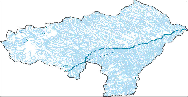
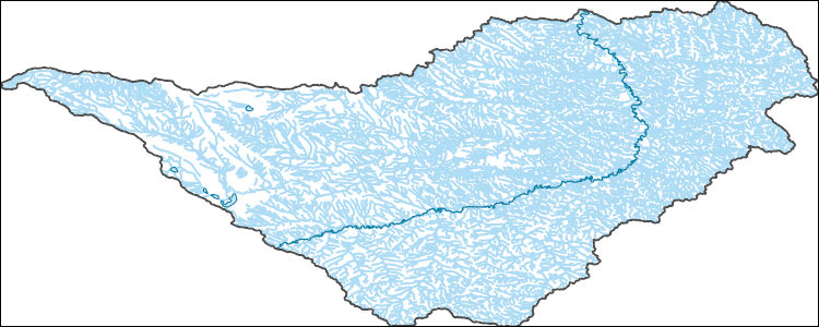
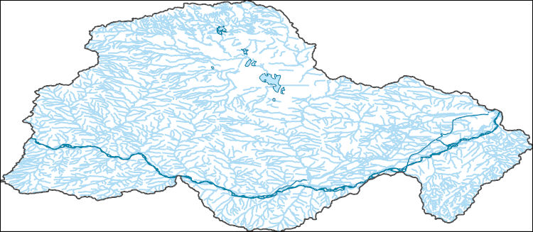
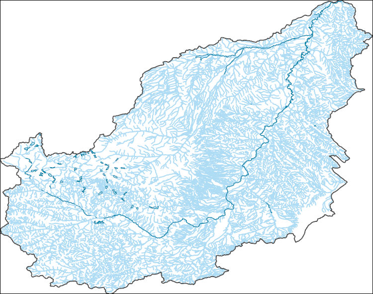
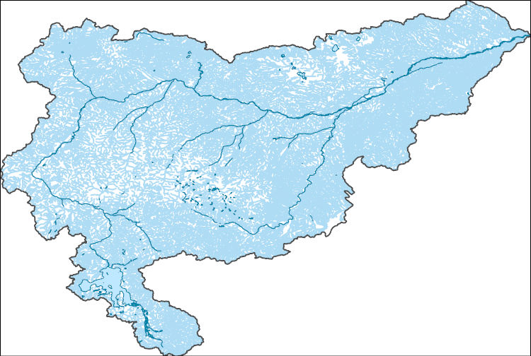
The Watershed Boundary Dataset (WBD) is a comprehensive aggregated collection of hydrologic unit data consistent with the national criteria for delineation and resolution. It defines the areal extent of surface water drainage to a point except in coastal or lake front areas where there could be multiple outlets as stated by the "Federal Standards and Procedures for the National Watershed Boundary Dataset (WBD)" "Standard" (https://pubs.usgs.gov/tm/11/a3/). Watershed boundaries are determined solely upon science-based hydrologic principles, not favoring any administrative boundaries or special projects, nor particular program or agency. This dataset represents the hydrologic unit boundaries to the 12-digit (6th level)...
Tags: 10-digit,
12-digit,
14-digit,
16-digit,
2-digit, All tags...
4-digit,
6-digit,
8-digit,
Adair,
Adams,
Albany,
Allen,
Anderson,
Andrew,
Antelope,
Appanoose,
Arapahoe,
Arthur,
Atchison,
Audrain,
Audubon,
Aurora,
Banner,
Barnes,
Barton,
Basin,
Bates,
Beadle,
Beaverhead,
Bennett,
Benton,
Big Horn,
Billings,
Blaine,
Bon Homme,
Boone,
Boulder,
Bourbon,
Bowman,
Box Butte,
Boyd,
Broadwater,
Brookings,
Broomfield,
Brown,
Brule,
Buchanan,
Buena Vista,
Buffalo,
Burke,
Burleigh,
Burt,
Butler,
Butte,
CO,
Caldwell,
Callaway,
Camden,
Campbell,
Carbon,
Carroll,
Carter,
Cascade,
Cass,
Cedar,
Chaffee,
Chariton,
Charles Mix,
Chase,
Cherokee,
Cherry,
Cheyenne,
Chouteau,
Christian,
Clark,
Clarke,
Clay,
Clear Creek,
Clinton,
Cloud,
Codington,
Coffey,
Cole,
Colfax,
Colorado,
Converse,
Cooper,
Corson,
Crawford,
Crook,
Cuming,
Custer,
Dade,
Dakota,
Dallas,
Daniels,
Daviess,
Davis,
Davison,
Dawes,
Dawson,
Day,
DeKalb,
Decatur,
Deer Lodge,
Dent,
Denver,
Deuel,
Dewey,
Dickey,
Dickinson,
Divide,
Dixon,
Dodge,
Doniphan,
Douglas,
Downloadable Data,
Dundy,
Dunn,
Eddy,
Edmunds,
El Paso,
Elbert,
Ellis,
Ellsworth,
Emmet,
Emmons,
Fall River,
Fallon,
Faulk,
Fergus,
Fillmore,
Flathead,
Foster,
Franklin,
Fremont,
Frontier,
Furnas,
Gage,
Gallatin,
Garden,
Garfield,
Gasconade,
Geary,
Gentry,
GeoPackage,
Gilpin,
Glacier,
Golden Valley,
Goshen,
Gosper,
Gove,
Graham,
Grand,
Granite,
Grant,
Greeley,
Greene,
Gregory,
Grundy,
Guthrie,
HU-2,
HU-2 Region,
HU2_10,
HUC,
Haakon,
Hall,
Hamilton,
Hamlin,
Hand,
Hanson,
Harding,
Harlan,
Harrison,
Hayes,
Henry,
Hettinger,
Hickory,
Hill,
Hitchcock,
Holt,
Hooker,
Hot Springs,
Howard,
Howell,
Hughes,
Hutchinson,
Hyde,
Hydrography,
Hydrologic Unit Code,
Hydrologic Units,
IA,
ID,
Ida,
Idaho,
Iowa,
Jackson,
Jefferson,
Jerauld,
Jewell,
Johnson,
Jones,
Judith Basin,
KS,
Kansas,
Kearney,
Keith,
Keya Paha,
Kidder,
Kimball,
Kingsbury,
Kit Carson,
Knox,
LaMoure,
Laclede,
Lafayette,
Lake,
Lancaster,
Lane,
Laramie,
Larimer,
Lawrence,
Leavenworth,
Lemhi,
Lewis and Clark,
Liberty,
Lincoln,
Linn,
Livingston,
Logan,
Loup,
Lucas,
Lyman,
Lyon,
MN,
MO,
MT,
Macon,
Madison,
Maries,
Marion,
Marshall,
McCone,
McCook,
McHenry,
McIntosh,
McKenzie,
McLean,
McPherson,
Meade,
Meagher,
Mellette,
Mercer,
Merrick,
Miami,
Miller,
Mills,
Miner,
Minnehaha,
Minnesota,
Missouri,
Mitchell,
Moniteau,
Monona,
Monroe,
Montana,
Montgomery,
Moody,
Morgan,
Morrill,
Morris,
Morton,
Mountrail,
Murray,
Musselshell,
ND,
NE,
Nance,
National Watershed Boundary Dataset (WBD),
National Watershed Boundary Dataset (WBD),
Natrona,
Nebraska,
Nemaha,
Ness,
Niobrara,
Nobles,
Nodaway,
North Dakota,
Norton,
Nuckolls,
O'Brien,
Oglala Lakota,
Oliver,
Open Geospatial Consortium GeoPackage 1.2,
Osage,
Osborne,
Osceola,
Otoe,
Ottawa,
Page,
Palo Alto,
Park,
Pawnee,
Pennington,
Perkins,
Petroleum,
Pettis,
Phelps,
Phillips,
Pierce,
Pipestone,
Platte,
Plymouth,
Polk,
Pondera,
Pottawatomie,
Pottawattamie,
Potter,
Powder River,
Powell,
Prairie,
Pulaski,
Putnam,
Randolph,
Ransom,
Ravalli,
Rawlins,
Ray,
Red Willow,
Region,
Republic,
Rice,
Richardson,
Richland,
Riley,
Ringgold,
Roberts,
Rock,
Rooks,
Roosevelt,
Rosebud,
Routt,
Rush,
Russell,
SD,
Sac,
Saline,
Sanborn,
Sargent,
Sarpy,
Saunders,
Schuyler,
Scott,
Scotts Bluff,
Sedgwick,
Seward,
Shawnee,
Shelby,
Sheridan,
Sherman,
Silver Bow,
Sioux,
Slope,
Smith,
South Dakota,
Spink,
St. Charles,
St. Clair,
St. Louis,
Stanley,
Stanton,
Stark,
Stillwater,
Stutsman,
Sub-basin,
Sub-region,
Sublette,
Subwatershed,
Sullivan,
Sully,
Summit,
Sweet Grass,
Sweetwater,
Taylor,
Teller,
Teton,
Texas,
Thayer,
Thomas,
Thurston,
Todd,
Toole,
Treasure,
Trego,
Tripp,
Turner,
US,
Union,
United States,
Valley,
Vernon,
WBD,
WY,
Wabaunsee,
Wallace,
Walworth,
Ward,
Warren,
Washakie,
Washington,
Watershed,
Watershed Boundary Dataset,
Wayne,
Webster,
Weld,
Wells,
Weston,
Wheatland,
Wheeler,
Wibaux,
Wichita,
Williams,
Woodbury,
Worth,
Wright,
Wyandotte,
Wyoming,
Yankton,
Yellowstone,
York,
Yuma,
Ziebach,
inlandWaters, Fewer tags

Climate change over the past century has altered vegetation community composition and species distributions across rangelands in the western United States. The scale and magnitude of climatic influences are largely unknown. We used fractional component cover data for rangeland functional groups and weather data from the 1985 to 2023 reference period in conjunction with soils and topography data to develop empirical models describing the spatio-temporal variation in component cover. To investigate the ramifications of future change across the western US, we extended models based on historical relationships over the reference period to model landscape effects based on future weather conditions from two emissions scenarios...
Tags: AB,
AZ,
Alberta,
Arizona,
Arizona Plateau, All tags...
Black Hills,
Blue Mountains,
CA,
CO,
California,
Canada,
Colorado,
Colorado Plateau,
Columbia Plateau,
Grand Canyon,
Great Basin,
Gunnison,
ID,
Idaho,
Land Use Change,
MT,
Middle Rockies,
Montana,
ND,
NE,
NM,
NV,
Nebraska,
Nevada,
New Mexico,
North Dakota,
OR,
Oregon,
Prairie Provinces,
Rocky Mountains,
SD,
SK,
Saskatchewan,
Snake River Plain,
Sonoran Desert,
South Dakota,
Southwest Tablelands,
Three Forks,
USGS Science Data Catalog (SDC),
UT,
United States,
Utah,
WA,
WY,
Wasatch,
Washington,
Western US,
Wyoming,
Yellowstone,
annual herbaceous,
bare ground,
biota,
climate change,
environment,
geoscientificInformation,
grass,
grassland change,
herbaceous,
imageryBaseMapsEarthCover,
litter,
rangeland,
rangeland management,
sagebrush,
shrub,
shrubland,
shrubland change,
shrubland ecosystems,
shrublands,
terrestrial ecosystems,
trends,
vegetation,
vegetation change, Fewer tags
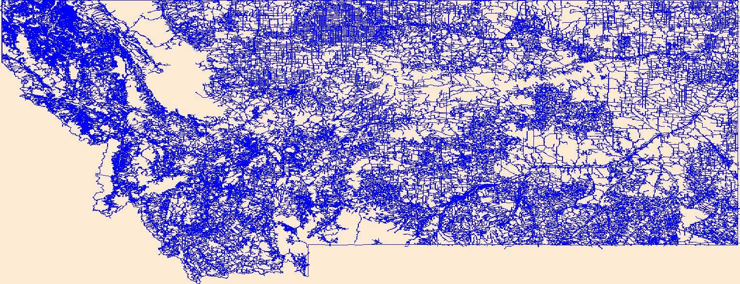
The National Hydrography Dataset (NHD) is a feature-based database that interconnects and uniquely identifies the stream segments or reaches that make up the nation's surface water drainage system. NHD data was originally developed at 1:100,000-scale and exists at that scale for the whole country. This high-resolution NHD, generally developed at 1:24,000/1:12,000 scale, adds detail to the original 1:100,000-scale NHD. (Data for Alaska, Puerto Rico and the Virgin Islands was developed at high-resolution, not 1:100,000 scale.) Local resolution NHD is being developed where partners and data exist. The NHD contains reach codes for networked features, flow direction, names, and centerline representations for areal water...
Tags: Administrative watershed units,
Administrative watershed units,
Area of Complex Channels,
Area to be submerged,
Basin, All tags...
Basin,
Bay/Inlet,
Big Horn,
Boundaries,
Boundary,
Bridge,
Canal/Ditch,
Coastline,
Connector,
Dam/Weir,
Downloadable Data,
Drainage areas for surface water,
Drainageway,
Estuary,
Flow direction network,
Flume,
ForeShore,
Gaging Station,
Gate,
GeoPackage,
Golden Valley,
HU-8,
HU-8 Subbasin,
HU10,
HU12,
HU14,
HU16,
HU2,
HU4,
HU6,
HU8,
HU8_10070007,
HUC,
Hazard Zone,
Hydrographic,
Hydrography,
Hydrography,
Hydrography,
Hydrologic Unit Code,
Hydrologic Units,
Ice mass,
Inundation Area,
Levee,
Line,
Lock Chamber,
MT,
Marsh,
Montana,
Musselshell,
National Hydrography Dataset (NHD),
National Hydrography Dataset (NHD) Best Resolution,
National Hydrography Dataset (NHD) Best Resolution,
Nonearthen Shore,
Open Geospatial Consortium GeoPackage 1.2,
Orthoimage,
Playa,
Point,
PointEvent,
Pond,
Rapids,
Rapids,
Reach,
Reach code,
Reef,
Region,
Reservoir,
Rock,
Sea/Ocean,
Sink/Rise,
Sounding Datum Line,
Special Use Zone,
Special Use Zone Limit,
Spillway,
Stillwater,
Stream,
Stream/River,
Sub-basin,
Sub-region,
Subbasin,
Submerged Stream,
Subregion,
Subwatershed,
Surface water systems,
Swamp,
Topographic,
Tunnel,
US,
Underground Conduit,
United States,
WBD,
WBD,
Wall,
Wash,
Water Intake Outflow,
Waterfall,
Watershed,
Watershed Boundaries,
Watershed Boundary Dataset,
Watershed Boundary Dataset,
Well,
Yellowstone,
artificial path,
boundaries,
dams,
drainage systems and characteristics,
inlandWaters,
lakes,
ngda,
rivers, Fewer tags

The National Hydrography Dataset (NHD) is a feature-based database that interconnects and uniquely identifies the stream segments or reaches that make up the nation's surface water drainage system. NHD data was originally developed at 1:100,000-scale and exists at that scale for the whole country. This high-resolution NHD, generally developed at 1:24,000/1:12,000 scale, adds detail to the original 1:100,000-scale NHD. (Data for Alaska, Puerto Rico and the Virgin Islands was developed at high-resolution, not 1:100,000 scale.) Local resolution NHD is being developed where partners and data exist. The NHD contains reach codes for networked features, flow direction, names, and centerline representations for areal water...
Tags: Administrative watershed units,
Administrative watershed units,
Area of Complex Channels,
Area to be submerged,
Basin, All tags...
Basin,
Bay/Inlet,
Big Horn,
Boundaries,
Boundary,
Bridge,
Canal/Ditch,
Carbon,
Coastline,
Connector,
Dam/Weir,
Downloadable Data,
Drainage areas for surface water,
Drainageway,
Esri Shapefile nan,
Estuary,
Flow direction network,
Flume,
ForeShore,
Gaging Station,
Gate,
HU-8,
HU-8 Subbasin,
HU10,
HU12,
HU14,
HU16,
HU2,
HU4,
HU6,
HU8,
HU8_10070006,
HUC,
Hazard Zone,
Hydrographic,
Hydrography,
Hydrography,
Hydrography,
Hydrologic Unit Code,
Hydrologic Units,
Ice mass,
Inundation Area,
Levee,
Line,
Lock Chamber,
MT,
Marsh,
Montana,
National Hydrography Dataset (NHD),
National Hydrography Dataset (NHD) Best Resolution,
National Hydrography Dataset (NHD) Best Resolution,
Nonearthen Shore,
Orthoimage,
Park,
Playa,
Point,
PointEvent,
Pond,
Rapids,
Rapids,
Reach,
Reach code,
Reef,
Region,
Reservoir,
Rock,
Sea/Ocean,
Shapefile,
Sink/Rise,
Sounding Datum Line,
Special Use Zone,
Special Use Zone Limit,
Spillway,
Stillwater,
Stream,
Stream/River,
Sub-basin,
Sub-region,
Subbasin,
Submerged Stream,
Subregion,
Subwatershed,
Surface water systems,
Swamp,
Topographic,
Tunnel,
US,
Underground Conduit,
United States,
WBD,
WBD,
WY,
Wall,
Wash,
Water Intake Outflow,
Waterfall,
Watershed,
Watershed Boundaries,
Watershed Boundary Dataset,
Watershed Boundary Dataset,
Well,
Wyoming,
Yellowstone,
artificial path,
boundaries,
dams,
drainage systems and characteristics,
inlandWaters,
lakes,
ngda,
rivers, Fewer tags
Layers of geospatial data include roads, airports, trails, and railroads.
Tags: Airport Complex,
Airport Point,
Airport Runway,
Airports,
Airstrips, All tags...
Beaverhead,
Big Horn,
Blaine,
Broadwater,
Carbon,
Carter,
Cascade,
Chouteau,
Custer,
Daniels,
Dawson,
Deer Lodge,
Downloadable Data,
Esri File GeoDatabase 10,
Fallon,
Fergus,
FileGDB,
Flathead,
Gallatin,
Garfield,
Geographic names,
Glacier,
Golden Valley,
Granite,
Hill,
Jefferson,
Judith Basin,
Lake,
Lewis and Clark,
Liberty,
Lincoln,
MT,
Madison,
McCone,
Meagher,
Mineral,
Missoula,
Montana,
Musselshell,
National Transportation Dataset (NTD),
National Transportation Dataset (NTD),
Park,
Petroleum,
Phillips,
Pondera,
Powder River,
Powell,
Prairie,
Railways,
Ravalli,
Richland,
Roads,
Roosevelt,
Rosebud,
Sanders,
Sheridan,
Silver Bow,
State,
State,
Stillwater,
Sweet Grass,
Teton,
Toole,
Trail,
Trails,
Transportation,
Transportation,
Treasure,
US,
United States,
Valley,
Waterway,
Wheatland,
Wibaux,
Yellowstone,
transportation, Fewer tags

The RCMAP (Rangeland Condition Monitoring Assessment and Projection) dataset quantifies the percent cover of rangeland components across western North America using Landsat imagery from 1985-2023. The RCMAP product suite consists of ten fractional components: annual herbaceous, bare ground, herbaceous, litter, non-sagebrush shrub, perennial herbaceous, sagebrush, shrub, tree, and shrub height in addition to the temporal trends of each component. Several enhancements were made to the RCMAP process relative to prior generations. First, high-resolution training was revised using an improved neural-net classifier and modelling approach. These data serve as foundation to the RCMAP approach. The training database was...
Tags: AB,
AZ,
Alberta,
Arizona,
Arizona Plateau, All tags...
Black Hills,
Blue Mountains,
CA,
CO,
California,
Canada,
Chihuahuan,
Chihuahuan Desert,
Colorado,
Colorado Plateau,
Columbia Plateau,
Desert,
Grand Canyon,
Great Basin,
Gunnison,
ID,
Idaho,
MT,
Mediterranean California,
Middle Rockies,
Mojave,
Montana,
ND,
NE,
NM,
NV,
Nebraska,
Nevada,
New Mexico,
North Dakota,
North Plains,
Northern Great Plains,
Northern Great Salt Lake Desert,
Northern Mountainous,
Northern Rocky Mountains,
OR,
Oregon,
Plains,
Plateau,
Prairie Provinces,
Rocky Mountains,
SD,
SK,
Saskatchewan,
Sierra Nevada,
Sonoran,
Sonoran Desert,
South Dakota,
Southern Great Salt Lake Desert,
Southern Rocky Mountains,
Southwest Tablelands,
TX,
Texas,
The Rockies,
Three Forks,
UT,
United States,
Utah,
WA,
WY,
Wasatch,
Washington,
Western US,
Wyoming,
Wyoming Basin,
Yellowstone,
annual herbaceous,
back-in-time,
bare ground,
big sagebrush,
biota,
climate change,
environment,
geoscientificInformation,
grass,
grassland change,
herbaceous,
imageryBaseMapsEarthCover,
litter,
mts,
rangeland,
rangeland management,
sagebrush,
shrub,
shrub height,
shrubland,
shrubland change,
shrubland ecosystems,
shrublands,
terrestrial ecosystems,
time series,
trends,
vegetation,
vegetation change,
vegetation height, Fewer tags

The RCMAP (Rangeland Condition Monitoring Assessment and Projection) dataset quantifies the percent cover of rangeland components across the western U.S. using Landsat imagery from 1985-2021. The RCMAP product suite consists of nine fractional components: annual herbaceous, bare ground, herbaceous, litter, non-sagebrush shrub, perennial herbaceous, sagebrush, shrub, and tree, in addition to the temporal trends of each component. Several enhancements were made to the RCMAP process relative to prior generations. First, we have trained time-series predictions directly from 331 high-resolution sites collected from 2013-2018 from Assessment, Inventory, and Monitoring (AIM) instead of using the 2016 “base” map as an intermediary....
Tags: AZ,
Arizona,
Arizona Plateau,
Black Hills,
Blue Mountains, All tags...
CA,
CO,
California,
Chihuahuan,
Chihuahuan Desert,
Colorado,
Colorado Plateau,
Columbia Plateau,
Desert,
Grand Canyon,
Great Basin,
Gunnison,
ID,
Idaho,
Land Use Change,
MT,
Mediterranean California,
Middle Rockies,
Mojave,
Montana,
ND,
NE,
NM,
NV,
Nebraska,
Nevada,
New Mexico,
North Dakota,
North Plains,
Northern Great Plains,
Northern Great Salt Lake Desert,
Northern Mountainous,
Northern Rocky Mountains,
OR,
Oregon,
Plains,
Plateau,
Rocky Mountains,
SD,
Sierra Nevada,
Sonoran,
Sonoran Desert,
South Dakota,
Southern Great Salt Lake Desert,
Southern Rocky Mountains,
Southwest Tablelands,
TX,
Texas,
The Rockies,
Three Forks,
USGS Science Data Catalog (SDC),
UT,
United States,
Utah,
WA,
WY,
Wasatch,
Washington,
Western US,
Wyoming,
Wyoming Basin,
Yellowstone,
annual herbaceous,
back-in-time,
bare ground,
big sagebrush,
biota,
climate change,
environment,
geoscientificInformation,
grass,
grassland change,
herbaceous,
imageryBaseMapsEarthCover,
litter,
mts,
rangeland,
rangeland management,
sagebrush,
shrub,
shrubland,
shrubland change,
shrubland ecosystems,
shrublands,
terrestrial ecosystems,
time series,
trends,
vegetation,
vegetation change, Fewer tags

Layers of geospatial data include contours, boundaries, land cover, hydrography, roads, transportation, geographic names, structures, and other selected map features.
Types: Citation;
Tags: 7.5 x 7.5 minute,
7_5_Min,
Combined Vector,
Combined Vector,
Combined Vector, All tags...
Downloadable Data,
Esri Shapefile nan,
MT,
Montana,
Public Land Survey System,
Shapefile,
Topo Map Vector Data,
US,
United States,
Yellowstone,
boundary,
contours,
geographic names,
hydrography,
structures,
transportation,
woodland, Fewer tags
The National Hydrography Dataset (NHD) is a feature-based database that interconnects and uniquely identifies the stream segments or reaches that make up the nation's surface water drainage system. NHD data was originally developed at 1:100,000-scale and exists at that scale for the whole country. This high-resolution NHD, generally developed at 1:24,000/1:12,000 scale, adds detail to the original 1:100,000-scale NHD. (Data for Alaska, Puerto Rico and the Virgin Islands was developed at high-resolution, not 1:100,000 scale.) Local resolution NHD is being developed where partners and data exist. The NHD contains reach codes for networked features, flow direction, names, and centerline representations for areal water...
Tags: Administrative watershed units,
Administrative watershed units,
Area of Complex Channels,
Area to be submerged,
Basin, All tags...
Basin,
Bay/Inlet,
Boundaries,
Boundary,
Bridge,
Canal/Ditch,
Coastline,
Connector,
Dam/Weir,
Downloadable Data,
Drainage areas for surface water,
Drainageway,
Estuary,
Fergus,
Flow direction network,
Flume,
ForeShore,
Gaging Station,
Garfield,
Gate,
GeoPackage,
Golden Valley,
HU-8,
HU-8 Subbasin,
HU10,
HU12,
HU14,
HU16,
HU2,
HU4,
HU6,
HU8,
HU8_10040202,
HUC,
Hazard Zone,
Hydrographic,
Hydrography,
Hydrography,
Hydrography,
Hydrologic Unit Code,
Hydrologic Units,
Ice mass,
Inundation Area,
Levee,
Line,
Lock Chamber,
MT,
Marsh,
Montana,
Musselshell,
National Hydrography Dataset (NHD),
National Hydrography Dataset (NHD) Best Resolution,
National Hydrography Dataset (NHD) Best Resolution,
Nonearthen Shore,
Open Geospatial Consortium GeoPackage 1.2,
Orthoimage,
Petroleum,
Playa,
Point,
PointEvent,
Pond,
Rapids,
Rapids,
Reach,
Reach code,
Reef,
Region,
Reservoir,
Rock,
Rosebud,
Sea/Ocean,
Sink/Rise,
Sounding Datum Line,
Special Use Zone,
Special Use Zone Limit,
Spillway,
Stream,
Stream/River,
Sub-basin,
Sub-region,
Subbasin,
Submerged Stream,
Subregion,
Subwatershed,
Surface water systems,
Swamp,
Topographic,
Tunnel,
US,
Underground Conduit,
United States,
WBD,
WBD,
Wall,
Wash,
Water Intake Outflow,
Waterfall,
Watershed,
Watershed Boundaries,
Watershed Boundary Dataset,
Watershed Boundary Dataset,
Well,
Yellowstone,
artificial path,
boundaries,
dams,
drainage systems and characteristics,
inlandWaters,
lakes,
ngda,
rivers, Fewer tags
The National Hydrography Dataset (NHD) is a feature-based database that interconnects and uniquely identifies the stream segments or reaches that make up the nation's surface water drainage system. NHD data was originally developed at 1:100,000-scale and exists at that scale for the whole country. This high-resolution NHD, generally developed at 1:24,000/1:12,000 scale, adds detail to the original 1:100,000-scale NHD. (Data for Alaska, Puerto Rico and the Virgin Islands was developed at high-resolution, not 1:100,000 scale.) Local resolution NHD is being developed where partners and data exist. The NHD contains reach codes for networked features, flow direction, names, and centerline representations for areal water...
Tags: Administrative watershed units,
Administrative watershed units,
Area of Complex Channels,
Area to be submerged,
Basin, All tags...
Basin,
Bay/Inlet,
Boundaries,
Boundary,
Bridge,
Canal/Ditch,
Carbon,
Coastline,
Connector,
Dam/Weir,
Downloadable Data,
Drainage areas for surface water,
Drainageway,
Estuary,
Flow direction network,
Flume,
ForeShore,
Gaging Station,
Gate,
GeoPackage,
HU-8,
HU-8 Subbasin,
HU10,
HU12,
HU14,
HU16,
HU2,
HU4,
HU6,
HU8,
HU8_10070004,
HUC,
Hazard Zone,
Hydrographic,
Hydrography,
Hydrography,
Hydrography,
Hydrologic Unit Code,
Hydrologic Units,
Ice mass,
Inundation Area,
Levee,
Line,
Lock Chamber,
MT,
Marsh,
Montana,
National Hydrography Dataset (NHD),
National Hydrography Dataset (NHD) Best Resolution,
National Hydrography Dataset (NHD) Best Resolution,
Nonearthen Shore,
Open Geospatial Consortium GeoPackage 1.2,
Orthoimage,
Playa,
Point,
PointEvent,
Pond,
Rapids,
Rapids,
Reach,
Reach code,
Reef,
Region,
Reservoir,
Rock,
Sea/Ocean,
Sink/Rise,
Sounding Datum Line,
Special Use Zone,
Special Use Zone Limit,
Spillway,
Stillwater,
Stream,
Stream/River,
Sub-basin,
Sub-region,
Subbasin,
Submerged Stream,
Subregion,
Subwatershed,
Surface water systems,
Swamp,
Sweet Grass,
Topographic,
Tunnel,
US,
Underground Conduit,
United States,
WBD,
WBD,
Wall,
Wash,
Water Intake Outflow,
Waterfall,
Watershed,
Watershed Boundaries,
Watershed Boundary Dataset,
Watershed Boundary Dataset,
Well,
Yellowstone,
artificial path,
boundaries,
dams,
drainage systems and characteristics,
inlandWaters,
lakes,
ngda,
rivers, Fewer tags
The National Hydrography Dataset (NHD) is a feature-based database that interconnects and uniquely identifies the stream segments or reaches that make up the nation's surface water drainage system. NHD data was originally developed at 1:100,000-scale and exists at that scale for the whole country. This high-resolution NHD, generally developed at 1:24,000/1:12,000 scale, adds detail to the original 1:100,000-scale NHD. (Data for Alaska, Puerto Rico and the Virgin Islands was developed at high-resolution, not 1:100,000 scale.) Local resolution NHD is being developed where partners and data exist. The NHD contains reach codes for networked features, flow direction, names, and centerline representations for areal water...
Tags: Administrative watershed units,
Administrative watershed units,
Area of Complex Channels,
Area to be submerged,
Basin, All tags...
Basin,
Bay/Inlet,
Big Horn,
Boundaries,
Boundary,
Bridge,
Canal/Ditch,
Carbon,
Coastline,
Connector,
Dam/Weir,
Downloadable Data,
Drainage areas for surface water,
Drainageway,
Estuary,
Flow direction network,
Flume,
ForeShore,
Gaging Station,
Gate,
GeoPackage,
HU-8,
HU-8 Subbasin,
HU10,
HU12,
HU14,
HU16,
HU2,
HU4,
HU6,
HU8,
HU8_10070006,
HUC,
Hazard Zone,
Hydrographic,
Hydrography,
Hydrography,
Hydrography,
Hydrologic Unit Code,
Hydrologic Units,
Ice mass,
Inundation Area,
Levee,
Line,
Lock Chamber,
MT,
Marsh,
Montana,
National Hydrography Dataset (NHD),
National Hydrography Dataset (NHD) Best Resolution,
National Hydrography Dataset (NHD) Best Resolution,
Nonearthen Shore,
Open Geospatial Consortium GeoPackage 1.2,
Orthoimage,
Park,
Playa,
Point,
PointEvent,
Pond,
Rapids,
Rapids,
Reach,
Reach code,
Reef,
Region,
Reservoir,
Rock,
Sea/Ocean,
Sink/Rise,
Sounding Datum Line,
Special Use Zone,
Special Use Zone Limit,
Spillway,
Stillwater,
Stream,
Stream/River,
Sub-basin,
Sub-region,
Subbasin,
Submerged Stream,
Subregion,
Subwatershed,
Surface water systems,
Swamp,
Topographic,
Tunnel,
US,
Underground Conduit,
United States,
WBD,
WBD,
WY,
Wall,
Wash,
Water Intake Outflow,
Waterfall,
Watershed,
Watershed Boundaries,
Watershed Boundary Dataset,
Watershed Boundary Dataset,
Well,
Wyoming,
Yellowstone,
artificial path,
boundaries,
dams,
drainage systems and characteristics,
inlandWaters,
lakes,
ngda,
rivers, Fewer tags
The Geographic Names Information System (GNIS) is the Federal standard for geographic nomenclature. The U.S. Geological Survey developed the GNIS for the U.S. Board on Geographic Names, a Federal inter-agency body chartered by public law to maintain uniform feature name usage throughout the Government and to promulgate standard names to the public. The GNIS is the official repository of domestic geographic names data; the official vehicle for geographic names use by all departments of the Federal Government; and the source for applying geographic names to Federal electronic and printed products of all types.
Tags: Antarctica,
Antarctica,
BGN,
Beaverhead,
Big Horn, All tags...
Blaine,
Board on Geographic Names,
Borough,
Broadwater,
Carbon,
Carter,
Cascade,
Census Area,
Chouteau,
Commonwealth,
County,
Custer,
Daniels,
Dawson,
Deer Lodge,
District,
Downloadable Data,
Fallon,
Feature class,
Feature coordinates,
Feature county,
Feature description,
Feature designation,
Feature history,
Feature indentification,
Feature name,
Feature state,
Fergus,
Flathead,
GNIS,
Gallatin,
Garfield,
Geographic Names,
Geographic Names Domestic Names,
Geographic Names Information System,
Geographic feature,
Geographic name,
Geographical feature,
Geographical name,
Glacier,
Golden Valley,
Granite,
Hill,
Jefferson,
Judith Basin,
Lake,
Lewis and Clark,
Liberty,
Lincoln,
MT,
Madison,
McCone,
Meagher,
Mineral,
Missoula,
Montana,
Municipio,
Musselshell,
National Geographic Names Information System (GNIS),
National Geographic Names Information System (GNIS),
Official feature name,
Outlying Area,
Parish,
Park,
Petroleum,
Phillips,
Place name,
Pondera,
Populated Place,
Powder River,
Powell,
Prairie,
Ravalli,
Richland,
Roosevelt,
Rosebud,
Sanders,
Sheridan,
Silver Bow,
State,
Stillwater,
Sweet Grass,
TXT (pipes),
Territories,
Territory,
Teton,
Toole,
Topographic Map,
Treasure,
U.S. Board on Geographic Names,
U.S. Geological Survey,
US,
USA,
USBGN,
USGS,
UTF-8 Pipe Delimited Text File nan,
United States,
United States,
United States,
Valley,
Variant name,
Wheatland,
Wibaux,
Yellowstone,
antarctic,
database,
economy,
environment,
feature,
gazetteer,
geographic,
geographic names,
geographical,
geography,
geospatial,
imageryBaseMapsEarthCover,
inlandWaters,
location,
map,
name,
place,
placename,
society,
structure,
topographic map,
toponymy, Fewer tags
The National Hydrography Dataset (NHD) is a feature-based database that interconnects and uniquely identifies the stream segments or reaches that make up the nation's surface water drainage system. NHD data was originally developed at 1:100,000-scale and exists at that scale for the whole country. This high-resolution NHD, generally developed at 1:24,000/1:12,000 scale, adds detail to the original 1:100,000-scale NHD. (Data for Alaska, Puerto Rico and the Virgin Islands was developed at high-resolution, not 1:100,000 scale.) Local resolution NHD is being developed where partners and data exist. The NHD contains reach codes for networked features, flow direction, names, and centerline representations for areal water...
Tags: Administrative watershed units,
Administrative watershed units,
Area of Complex Channels,
Area to be submerged,
Basin, All tags...
Basin,
Bay/Inlet,
Big Horn,
Boundaries,
Boundary,
Bridge,
Canal/Ditch,
Carbon,
Coastline,
Connector,
Dam/Weir,
Downloadable Data,
Drainage areas for surface water,
Drainageway,
Estuary,
Flow direction network,
Flume,
ForeShore,
Fremont,
Gaging Station,
Gallatin,
Gate,
GeoPackage,
Golden Valley,
HU-4,
HU-4 Subregion,
HU10,
HU12,
HU14,
HU16,
HU2,
HU4,
HU4_1007,
HU6,
HU8,
HUC,
Hazard Zone,
Hydrographic,
Hydrography,
Hydrography,
Hydrography,
Hydrologic Unit Code,
Hydrologic Units,
Ice mass,
Inundation Area,
Levee,
Line,
Lock Chamber,
MT,
Marsh,
Meagher,
Montana,
Musselshell,
National Hydrography Dataset (NHD),
National Hydrography Dataset (NHD) Best Resolution,
National Hydrography Dataset (NHD) Best Resolution,
Nonearthen Shore,
Open Geospatial Consortium GeoPackage 1.2,
Orthoimage,
Park,
Playa,
Point,
PointEvent,
Pond,
Rapids,
Rapids,
Reach,
Reach code,
Reef,
Region,
Reservoir,
Rock,
Sea/Ocean,
Sink/Rise,
Sounding Datum Line,
Special Use Zone,
Special Use Zone Limit,
Spillway,
Stillwater,
Stream,
Stream/River,
Sub-basin,
Sub-region,
Subbasin,
Submerged Stream,
Subregion,
Subwatershed,
Surface water systems,
Swamp,
Sweet Grass,
Teton,
Topographic,
Tunnel,
US,
Underground Conduit,
United States,
WBD,
WBD,
WY,
Wall,
Wash,
Water Intake Outflow,
Waterfall,
Watershed,
Watershed Boundaries,
Watershed Boundary Dataset,
Watershed Boundary Dataset,
Well,
Wyoming,
Yellowstone,
artificial path,
boundaries,
dams,
drainage systems and characteristics,
inlandWaters,
lakes,
ngda,
rivers, Fewer tags
Geospatial data includes structures and other selected map features.
Tags: Beaverhead,
Big Horn,
Blaine,
Broadwater,
Campground, All tags...
Carbon,
Carter,
Cascade,
Chouteau,
College / University,
Courthouse,
Custer,
Daniels,
Dawson,
Deer Lodge,
Downloadable Data,
Esri Shapefile nan,
Fallon,
Fergus,
Fire Station/ EMS Station,
Flathead,
Gallatin,
Garfield,
Glacier,
Golden Valley,
Granite,
Hill,
Hospital/Medical Center,
Information Center,
Jefferson,
Judith Basin,
Lake,
Law Enforcement,
Lewis and Clark,
Liberty,
Lincoln,
MT,
Madison,
McCone,
Meagher,
Mineral,
Missoula,
Montana,
Musselshell,
National Structures Dataset (NSD),
National Structures Dataset (NSD),
Park,
Petroleum,
Phillips,
Pondera,
Post Office,
Powder River,
Powell,
Prairie,
Prison/ Correctional Facility,
Ravalli,
Richland,
Roosevelt,
Rosebud,
Sanders,
School,
School:Elementary,
School:High School,
School:Middle School,
Shapefile,
Sheridan,
Silver Bow,
State,
State,
State Capitol,
Stillwater,
Structures,
Sweet Grass,
Technical School,
Teton,
Toole,
Town Hall,
Trade School,
Trailhead,
Treasure,
US,
United States,
Valley,
Visitor Center,
Wheatland,
Wibaux,
Yellowstone,
structure, Fewer tags
Geospatial data is comprised of government boundaries.
Tags: Beaverhead,
Big Horn,
Blaine,
Boundaries,
Broadwater, All tags...
Carbon,
Carter,
Cascade,
Chouteau,
County or Equivalent,
Custer,
Daniels,
Dawson,
Deer Lodge,
Downloadable Data,
Esri Shapefile nan,
Fallon,
Fergus,
Flathead,
Gallatin,
Garfield,
Glacier,
Golden Valley,
Granite,
Hill,
Incorporated Place,
Jefferson,
Judith Basin,
Jurisdictional,
Lake,
Lewis and Clark,
Liberty,
Lincoln,
MT,
Madison,
McCone,
Meagher,
Mineral,
Minor Civil Division,
Missoula,
Montana,
Musselshell,
National Boundary Dataset (NBD),
National Boundary Dataset (NBD),
Native American Area,
PLSS First Division,
PLSS Special Survey,
PLSS Township,
Park,
Petroleum,
Phillips,
Pondera,
Powder River,
Powell,
Prairie,
Public Land Survey System,
Ravalli,
Reserve,
Richland,
Roosevelt,
Rosebud,
Sanders,
Shapefile,
Sheridan,
Silver Bow,
State,
State,
State or Territory,
Stillwater,
Sweet Grass,
Teton,
Toole,
Treasure,
U.S. National Grid,
US,
Unincorporated Place,
United States,
Valley,
Wheatland,
Wibaux,
Yellowstone,
boundaries,
boundary,
cadastral surveys,
geographic names,
land ownership,
land use maps,
legal land descriptions,
political and administrative boundaries,
zoning maps, Fewer tags
Layers of geospatial data include contours, boundaries, land cover, hydrography, roads, transportation, geographic names, structures, and other selected map features.
Types: Citation;
Tags: 7.5 x 7.5 minute,
7_5_Min,
Combined Vector,
Combined Vector,
Combined Vector, All tags...
Downloadable Data,
Esri File GeoDatabase 10,
FileGDB,
MT,
Montana,
Public Land Survey System,
Topo Map Vector Data,
US,
United States,
Yellowstone,
boundary,
contours,
geographic names,
hydrography,
structures,
transportation,
woodland, Fewer tags
Layers of geospatial data include contours, boundaries, land cover, hydrography, roads, transportation, geographic names, structures, and other selected map features.
Types: Citation;
Tags: 7.5 x 7.5 minute,
7_5_Min,
Combined Vector,
Combined Vector,
Combined Vector, All tags...
Downloadable Data,
Esri Shapefile nan,
MT,
Montana,
Public Land Survey System,
Shapefile,
Topo Map Vector Data,
US,
United States,
Yellowstone,
boundary,
contours,
geographic names,
hydrography,
structures,
transportation,
woodland, Fewer tags

The RCMAP (Rangeland Condition Monitoring Assessment and Projection) dataset quantifies the percent cover of rangeland components across western North America using Landsat imagery from 1985-2023. The RCMAP product suite consists of ten fractional components: annual herbaceous, bare ground, herbaceous, litter, non-sagebrush shrub, perennial herbaceous, sagebrush, shrub, tree, and shrub height in addition to the temporal trends of each component. Several enhancements were made to the RCMAP process relative to prior generations. First, high-resolution training was revised using an improved neural-net classifier and modelling approach. These data serve as foundation to the RCMAP approach. The training database was...
Tags: AB,
AZ,
Alberta,
Arizona,
Arizona Plateau, All tags...
Black Hills,
Blue Mountains,
CA,
CO,
California,
Canada,
Chihuahuan,
Chihuahuan Desert,
Colorado,
Colorado Plateau,
Columbia Plateau,
Desert,
Grand Canyon,
Great Basin,
Gunnison,
ID,
Idaho,
MT,
Mediterranean California,
Middle Rockies,
Mojave,
Montana,
ND,
NE,
NM,
NV,
Nebraska,
Nevada,
New Mexico,
North Dakota,
North Plains,
Northern Great Plains,
Northern Great Salt Lake Desert,
Northern Mountainous,
Northern Rocky Mountains,
OR,
Oregon,
Plains,
Plateau,
Prairie Provinces,
Rocky Mountains,
SD,
SK,
Saskatchewan,
Sierra Nevada,
Sonoran,
Sonoran Desert,
South Dakota,
Southern Great Salt Lake Desert,
Southern Rocky Mountains,
Southwest Tablelands,
TX,
Texas,
The Rockies,
Three Forks,
UT,
United States,
Utah,
WA,
WY,
Wasatch,
Washington,
Western US,
Wyoming,
Wyoming Basin,
Yellowstone,
annual herbaceous,
back-in-time,
bare ground,
big sagebrush,
biota,
climate change,
environment,
geoscientificInformation,
grass,
grassland change,
herbaceous,
imageryBaseMapsEarthCover,
litter,
mts,
rangeland,
rangeland management,
sagebrush,
shrub,
shrub height,
shrubland,
shrubland change,
shrubland ecosystems,
shrublands,
terrestrial ecosystems,
time series,
trends,
vegetation,
vegetation change,
vegetation height, Fewer tags
The National Hydrography Dataset (NHD) is a feature-based database that interconnects and uniquely identifies the stream segments or reaches that make up the nation's surface water drainage system. NHD data was originally developed at 1:100,000-scale and exists at that scale for the whole country. This high-resolution NHD, generally developed at 1:24,000/1:12,000 scale, adds detail to the original 1:100,000-scale NHD. (Data for Alaska, Puerto Rico and the Virgin Islands was developed at high-resolution, not 1:100,000 scale.) Local resolution NHD is being developed where partners and data exist. The NHD contains reach codes for networked features, flow direction, names, and centerline representations for areal water...
Tags: Administrative watershed units,
Administrative watershed units,
Area of Complex Channels,
Area to be submerged,
Basin, All tags...
Basin,
Bay/Inlet,
Big Horn,
Boundaries,
Boundary,
Bridge,
Canal/Ditch,
Coastline,
Connector,
Custer,
Dam/Weir,
Downloadable Data,
Drainage areas for surface water,
Drainageway,
Esri File GeoDatabase 10,
Estuary,
FileGDB,
Flow direction network,
Flume,
ForeShore,
Gaging Station,
Garfield,
Gate,
HU-8,
HU-8 Subbasin,
HU10,
HU12,
HU14,
HU16,
HU2,
HU4,
HU6,
HU8,
HU8_10100001,
HUC,
Hazard Zone,
Hydrographic,
Hydrography,
Hydrography,
Hydrography,
Hydrologic Unit Code,
Hydrologic Units,
Ice mass,
Inundation Area,
Levee,
Line,
Lock Chamber,
MT,
Marsh,
Montana,
Musselshell,
National Hydrography Dataset (NHD),
National Hydrography Dataset (NHD) Best Resolution,
National Hydrography Dataset (NHD) Best Resolution,
Nonearthen Shore,
Orthoimage,
Playa,
Point,
PointEvent,
Pond,
Prairie,
Rapids,
Rapids,
Reach,
Reach code,
Reef,
Region,
Reservoir,
Rock,
Rosebud,
Sea/Ocean,
Sink/Rise,
Sounding Datum Line,
Special Use Zone,
Special Use Zone Limit,
Spillway,
Stream,
Stream/River,
Sub-basin,
Sub-region,
Subbasin,
Submerged Stream,
Subregion,
Subwatershed,
Surface water systems,
Swamp,
Topographic,
Treasure,
Tunnel,
US,
Underground Conduit,
United States,
WBD,
WBD,
Wall,
Wash,
Water Intake Outflow,
Waterfall,
Watershed,
Watershed Boundaries,
Watershed Boundary Dataset,
Watershed Boundary Dataset,
Well,
Yellowstone,
artificial path,
boundaries,
dams,
drainage systems and characteristics,
inlandWaters,
lakes,
ngda,
rivers, Fewer tags
|
|

