Filters: Tags: allotment (X)
20 results (16ms)|
Filters
Date Range
Extensions Types Contacts
Categories Tag Types Tag Schemes |
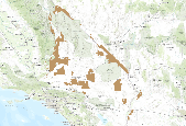
This is an aggregate dataset for the DRECP 12 km buffer region, depicting the geographic boundaries of Grazing Allotments within BLM managed public lands. An allotment is an area of land designated and managed for grazing of livestock (43 CFR 4100.0-5). An allotment may include private, state, and public lands under the jurisdiction of the Bureau of Land Management and/or other federal agencies. An allotment may be subdivided into pastures. Range improvement projects are not depicted within this dataset.
Allotments for rancher wolf sightings
This zipped file contains grazing data (shapefiles and tables) for the Carson National Forest in New Mexico. Descriptions from attached metadata: The rmu_unit feature class depicts the boundaries of the range Allotments, General Resource Areas, and Wild Horse and Burro territories on the Carson National Forest. The rmu_subunit feature class depicts the boundaries of the range pastures and range exclosures on the Carson National Forest.
Categories: Data;
Types: Downloadable,
Shapefile;
Tags: Allotment,
RMU,
Range,
Rangeland Management Unit,
Resource Management Unit,
This data represents grazing allotment boundaries managed by the BLM. Allotments are permitted use areas for public grazing of cattle, sheep and horses. Allotments can be a mixture of different surface ownerships, for example a BLM allotment can encompass privately owned land or state land Allotments can also be leased to various types of livestock, cattle, sheep and/or horses.
A consolidated grazing dataset representing BLM and FS submissions, with ownership indicated in the 'Mngmnt' field. Overlaps are identified as "BLMFS". BLM - GSSP allotments and pastures merged, overlaps removed, and dissolved to one polygon. GSSP SNAPSHOT of Approved data set made on 5/14/12 for the Greater Sage-grouse baseline rangewide cumulative effects analysis. This aggregate national dataset identifies allotments within BLM managed public lands. FS - This allotment layer is a merged and dissolved representation of the 27 allotment data files submitted to the BLM by the USFS for the GRSG CEA. As needed, records with ‘Unit_Type’ = 1 were selected for the merge, while the remainder were omitted. Additionally,...
Grazing allotments administered by the Kemmerer Field Office.
Data can be accessed through a map service (select one of the options in the grey bar above the inset map) or viewed in the BLM's GeoCommunicator interactive map.
Categories: Data,
Web Site;
Types: ArcGIS REST Map Service,
Map Service;
Tags: Allotment,
BLM,
GRA,
Grazing,
Livestock,
The allotment (Range Management Unit) feature class depicts the boundaries of range allotments and wild horse territory on the Dixie National Forest. Each unit is a designated area of land available for livestock grazing.

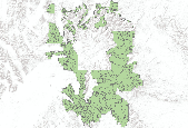
This is Arizona Bureau of Land Management (BLM) statewide grazing allotment data. This polygon feature class depicts the boundaries of the livestock grazing allotments located within the Arizona BLM, Arizona, USA. Each allotment has one or more pastures. In some cases, this layer identifies the BLM managed public land or other land associated with specific grazing allotments administered by the local BLM field office. Boundaries may be fences, arbitrary lines, or natural barriers. Agency management of polygons within this feature class is not specific to BLM; other agencies are also included.
This fencing potential layer is a merged representation of the 27 allotment data files submitted to the BLM by the USFS for the GRSG CEA and the GSSP snapshot of approved BLM grazing data made on 5/24/2012. This aggregate national dataset identifies pasture and allotment borders, represented as linear features, within BLM and FS managed public lands. This dataset serves as a surrogate for fencing potential across BLM and FS managed lands. Pasture and allotment polygons were converted to linear features using the “Polygon to Line” tool in ArcGIS. To identify areas of overlap between the BLM and FS data, an intersect operation was performed. The results were used to erase the overlapping geometry to avoid double counting....
This dataset was created for the GRSG National Planning Effort from the 2008 BLM Land Health spreadsheet. Sherm Karl edited this spreadsheet to indicate those allotments in which the habitat land health standard is not being achieved and livestock grazing is a causal factor in the non-achievement. These allotments were then joined to the GSSP National Allotment database on 6/28/12. Of the 1135 allotment records from the spreadsheet, 21 were not able to be mapped. Data Assumption notes: Sherm Karl - We can only assume the data are as current as 2007. Additional allotments have been assessed since then, but we do not have this information in a national data set, so we should date this as the 2008 assessment. Also,...
This coverage represents the range allotment boundaries of the Fishlake National Forest. Source data used were quad-based paper range allotment and analysis maps.
Reindeer grazing allotment polygons, with owner name, and grazing range monitoring data for reindeer on the Seward Peninsula from 2000 to 2010. These data are provided by Bureau of Land Management (BLM) "as is" and may contain errors or omissions. The User assumes the entire risk associated with its use of these data and bears all responsibility in determining whether these data are fit for the User's intended use. These data may not have the accuracy, resolution, completeness, timeliness, or other characteristics appropriate for applications that potential users of the data may contemplate. The User is encouraged to carefully consider the content of the metadata file associated with these data. The BLM should be...
This zipped file contains grazing data (shapefiles and tables) for the Cibola National Forest in New Mexico. Descriptions from attached metadata: The rmu_unit feature class depicts the boundaries of the range Allotments, General Resource Areas, and Wild Horse and Burro territories. The rmu_subunit feature class depicts the boundaries of the range pastures and range exclosures. The Keyarea feature class depicts the key area boundaries - key areas depict monitoring area boundaries within each pasture.
This zipped file contains grazing data (shapefiles and tables) for the Carson National Forest in New Mexico. Descriptions from attached metadata: The rmu_unit feature class depicts the boundaries of the range Allotments, General Resource Areas, and Wild Horse and Burro territories on the Carson National Forest. The rmu_subunit feature class depicts the boundaries of the range pastures and range exclosures on the Carson National Forest.
Categories: Data;
Types: Downloadable,
Shapefile;
Tags: Allotment,
RMU,
Range,
Rangeland Management Unit,
wild horse and burro territories
This coverage represents the range allotment boundaries of the Fishlake National Forest. Source data used were quad-based paper range allotment and analysis maps.
This zipped file contains grazing data (shapefiles and tables) for the Cibola National Forest in New Mexico. Descriptions from attached metadata: The rmu_unit feature class depicts the boundaries of the range Allotments, General Resource Areas, and Wild Horse and Burro territories. The rmu_subunit feature class depicts the boundaries of the range pastures and range exclosures. The Keyarea feature class depicts the key area boundaries - key areas depict monitoring area boundaries within each pasture.
Categories: Data;
Types: Downloadable,
Shapefile;
Tags: Allotment,
RMU,
Range,
Rangeland Management Unit,
Resource Management Unit
This dataset was created for the GRSG National Planning Effort from the 2008 BLM Land Health spreadsheet. Sherm Karl edited this spreadsheet to indicate those allotments in which a land health evaluation has not yet been done. These allotments were then joined to the GSSP National Allotment database on 6/28/12. Of the 10623 allotment records from the spreadsheet, 158 were not able to be mapped. Data Assumption notes: Sherm Karl - We can only assume the data are as current as 2007. Additional allotments have been assessed since then, but we do not have this information in a national data set, so we should date this as the 2008 assessment. Also, here are some assumptions I made regarding allotments that have more...
The Unit feature class depicts the boundaries of the range allotments, General Resource Areas, and Wild Horse and Burro territories on the Kaibab National Forest. These three features classes were merged to create the rmu_unit feature class. Each allotment is a designated area of land available for livestock grazing, and may be subdivided into pastures necessary for grazing management. General resource areas are boundaries outside of an established allotment. These areas are managed according to the parameters set by the legislative act. Associated National Application: Infrastructure (INFRA) Range INFRA Web Page: http://infra.wo.fs.fed.us/infra/
This zipped file contains grazing data (shapefiles and tables) for the Cibola National Forest in New Mexico. Descriptions from attached metadata: The rmu_unit feature class depicts the boundaries of the range Allotments, General Resource Areas, and Wild Horse and Burro territories. The rmu_subunit feature class depicts the boundaries of the range pastures and range exclosures. The Keyarea feature class depicts the key area boundaries - key areas depict monitoring area boundaries within each pasture.
Categories: Data;
Types: Downloadable,
Shapefile;
Tags: Allotment,
RMU,
Range,
Rangeland Management Unit,
Resource Management Unit,
|

|
