Filters: Tags: availability (X)
5 results (45ms)|
Filters
Date Range
Extensions Types Contacts
Categories Tag Types Tag Schemes |
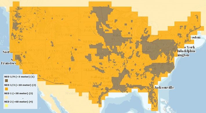
The USGS Elevation Availability service from The National Map (TNM) shows the best available resolution of downloadable elevation data, and is updated approximately every two weeks with National Elevation Dataset (NED) releases. NED 2- (in Alaska only), 1-, and 1/3-arc-second data are staged for download by 1x1 degree tiles in ArcGrid, GridFloat, or IMG formats in The National Map viewer, while NED 1/9 arc-second data is staged by 15x15 minute tiles in IMG format only. For additional information on the NED, go to http://ned.usgs.gov/.
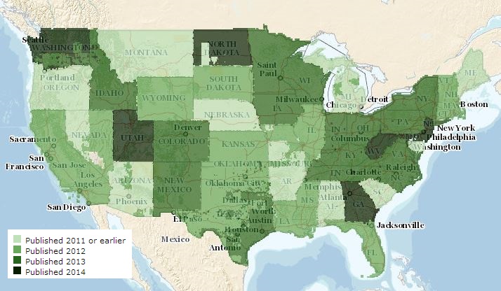
The USGS US Topo Availability service from The National Map (TNM) consists of footprints where US Topo is available in GeoPDF format. Various green tints are used to reflect the year in which latest US Topo map products are published. Information about the latest available US Topo maps can be discovered as well as product downloads from this service through an 'Identify' query. Service content is updated daily to ensure the most current map product is represented. If a user wants to download all current and historical USGS Topo Maps over a given area, these products are available at The National Map viewer (http://viewer.nationalmap.gov/viewer) or the USGS Store (http://store.usgs.gov). For additional information...
We studied effects of disturbance on migrating waterbirds during spring on Cumberland Pool at Tishomingo National Wildlife Refuge, Tishomingo, Oklahoma, USA, 1999 and 2000. We recorded 240 disturbances in 477.5 hr of observation of American coots (Fulica americana), American white pelicans (Pelecanus erythrorhynchos), black terns (Chlidonias niger), blue-winged teal (Anas discors), and Franklin's gulls (Larus pipixcan). Recreation (n= 208) accounted for 86.7% of all disturbances, natural disturbances (n = 23) accounted for 9.6%, and 3.3% of disturbances (n = 8) were unknown. Boat fishing increased alertness by American white pelicans but did not affect escape behavior. Recreational disturbances caused increases...
Categories: Publication;
Types: Citation;
Tags: Effects,
availability,
energy,
global warming,
wind,

The USGS Elevation Availability service from The National Map (TNM) shows the best available resolution of downloadable elevation data, and is updated approximately every weeks with 3D Elevation Program (3DEP) releases. Alaska 2 arc-second, 1 arc-second, and 1/3-arc-second data are staged for download by 1x1 degree tiles in ArcGrid, GridFloat, or IMG formats in The National Map viewer, while 1/9 arc-second data is staged by 15x15 minute tiles in IMG format only. For additional information on the 3D Elevation Program (3DEP), go to https://nationalmap.gov/3DEP/.
Human activity causes wintering waterfowl to expend energy to avoid humans at a time in their annual cycle when energy conservation is important to survival, migration, and breeding reserves. Understanding the effects of recreational activities on waterfowl is important to managing natural resource areas where migratory birds depend on wetland habitat for resting and feeding. We investigated responses of 7 species of dabbling ducks to 5 different experimental human activities, (a pedestrian, a bicyclist, a truck traveling at 2 different speeds, and an electric passenger tram). Responses of ducks depended on type of disturbance, species, and distance from disturbances. Most birds responded to the treatments. People...
Categories: Publication;
Types: Citation;
Tags: Effects,
availability,
energy,
global warming,
wind,
|

|
