Filters: Tags: california (X)
22,162 results (38ms)|
Filters
Date Range
Extensions Types
Contacts
Categories Tag Types
|

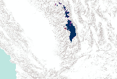
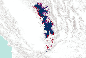
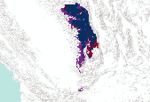
The source of this coverage data set is the fish biodiversity maps created for The Nature Conservancy (TNC) as part of their Hexagon Project. Professor Peter Moyle and his graduate student, Paul Randall, of the Department of Wildlife and Fisheries Conservation Biology at the University of California, Davis were hired to produce range maps for all known fish species that presently occur in California. Each coverage denotes a separate fish species (refer to the species coverage key below). The polygons are estimated to be accurate at a scale of roughly 1:1,000,000. Other California fish species distributions can be found in a gallery at: http://app.databasin.org/app/pages/galleryPage.jsp?id=099b47b7394f47b6b42764829e8a8f09

The source of this coverage data set is the fish biodiversity maps created for The Nature Conservancy (TNC) as part of their Hexagon Project. Professor Peter Moyle and his graduate student, Paul Randall, of the Department of Wildlife and Fisheries Conservation Biology at the University of California, Davis were hired to produce range maps for all known fish species that presently occur in California. Each coverage denotes a separate fish species (refer to the species coverage key below). The polygons are estimated to be accurate at a scale of roughly 1:1,000,000. Other California fish species distributions can be found in a gallery at: http://app.databasin.org/app/pages/galleryPage.jsp?id=099b47b7394f47b6b42764829e8a8f09

This dataset represents a subset of the original USDA Forest Service map spanning 1878-2007. This map depicts only fires from 1878-1899. The original metadata for the entire dataset is below:This dataset represents USDA Forest Service fire perimeters 10+ acres and California Dept of Forestry fire perimeters 300+ acres occurring from the year 1950 to 2007. The geographic extent of the fires includes the State of California, Region 5 Forests (some R5 Forests have boundaries falling outside CA) and the Toiyabe National Forest in Region 4. Some fires before 1950 are also included. Fires are compiled from both historic and recently mapped records. This layer contains records up to and including fires from 2007.

These data identify, in general, the areas where final critical habitat for the Coachella Valley fringe-toed lizard (Uma inornata) occur.
These data identify, in general, the areas where final critical habitat for the coastal California gnatcatcher (Polioptila californica californica) occur.

Modal vegetation class over 1986 – 2005, simulated with MC1 (Lenihan et al. 2008) and a 10 km x 10 km grid cell size. Grid Value: Vegetation Type 1: ALPINE 2: SUBALPINE FOREST 3: COAST EVERGREEN FOREST 11: PINYON-JUNIPER 4: SIERRAN EVERGREEN FOREST 6: MIXED EVERGREEN FOREST 15: GREAT BASIN EVERGREEN WOODLAND 10: MIXED EVERGREEN WOODLAND 20: SAGEBRUSH STEPPE 17: C3 GRASSLAND 18: C4 GRASSLAND 19: CHAPARRAL 17: C3 GRASSLAND 18: C4 GRASSLAND 21: DESERT

This dataset respresents the soils with high volcanic content (pumice or volcanic glass) in the North Pacific Landscape Conservation Cooperative.
The evapotranspiration (ET) datasets were created under contract for this study by the University of Idaho. A high-resolution remote sensing technique known as Mapping Evapotranspiration at High Resolution and Internalized Calibration (METRIC) was used to create estimates of the spatial distribution of ET. The METRIC technique uses thermal infrared Landsat imagery to quantify actual evapotranspiration at a 30-meter resolution that can be related to individual irrigated fields. Because evaporation uses heat energy, ground surfaces with large ET rates are left cooler as a result of ET than ground surfaces that have less ET. As a consequence, irrigated fields appear in the Landsat images as cooler than nonirrigated...

These data are forecast barren land change under the PCM A2 scenarios, calculated using the outputs from runs of the USFS Pacific Northwest Research Station and WWETAC MC1 Vegetation model.MC1 Vegetation Model description: This collection of layers includes summary statistics from input and output data used for simulation of vegetation response to climate change in California. The simulations were performed using MC1 dynamic global vegetation model (DGVM), source code revision 152. The model was parameterized and evaluated by the DGVM research group at the US Forest Service Pacific Northwest Research Station, with support from the Western Wildland Environmental Threat Assessment Center. The model was parameterized...

These data are forecast barren land change under the GFDL B1 scenarios, calculated using the outputs from runs of the USFS Pacific Northwest Research Station and WWETAC MC1 Vegetation model.MC1 Vegetation Model description: This collection of layers includes summary statistics from input and output data used for simulation of vegetation response to climate change in California. The simulations were performed using MC1 dynamic global vegetation model (DGVM), source code revision 152. The model was parameterized and evaluated by the DGVM research group at the US Forest Service Pacific Northwest Research Station, with support from the Western Wildland Environmental Threat Assessment Center. The model was parameterized...

These data are forecast barren land change under the PCM A2&B1 scenarios, calculated using the outputs from runs of the USFS Pacific Northwest Research Station and WWETAC MC1 Vegetation model.MC1 Vegetation Model description: This collection of layers includes summary statistics from input and output data used for simulation of vegetation response to climate change in California. The simulations were performed using MC1 dynamic global vegetation model (DGVM), source code revision 152. The model was parameterized and evaluated by the DGVM research group at the US Forest Service Pacific Northwest Research Station, with support from the Western Wildland Environmental Threat Assessment Center. The model was parameterized...

This collection of layers includes summary statistics from input and output data used for simulation of vegetation response to climate change in California. The historical data layers represent the 30 year period from 1961 to 1990. Future data layers represent each four 20 year periods: 2010-2029, 2030-2049, 2060-2079, and 2080-2099. The simulations were performed using MC1 dynamic global vegetation model (DGVM), source code revision 152. The model was parameterized and evaluated by the DGVM research group at the US Forest Service Pacific Northwest Research Station, with support from the Western Wildland Environmental Threat Assessment Center. The model was parameterized to maximize concordance with maps of potential...

The Nature Conservancy (TNC) has derived climate suitability forecasts for most species of trees and shrubs considered to be ecological dominants of terrestrial Californian habitat types. Our plant projections are compiled as decision support tools to help Conservancy project staff, as well as our external partners, develop the necessary plans, priorities and strategies to successfully adapt to uncertain changes in future climate. In the recently completed Southern Sierra Partnership's 2010 Climate-Adapted Conservation Plan for the Southern Sierra Nevada and Tehachapi Mountains, species and habitat forecasts shown here informed the development of a regional conservation design that explicitly incorporates long-term...
The Nature Conservancy (TNC) has derived climate suitability forecasts for most species of trees and shrubs considered to be ecological dominants of terrestrial Californian habitat types. Our plant projections are compiled as decision support tools to help Conservancy project staff, as well as our external partners, develop the necessary plans, priorities and strategies to successfully adapt to uncertain changes in future climate. In the recently completed Southern Sierra Partnership's 2010 Climate-Adapted Conservation Plan for the Southern Sierra Nevada and Tehachapi Mountains, species and habitat forecasts shown here informed the development of a regional conservation design that explicitly incorporates long-term...
The Nature Conservancy (TNC) has derived climate suitability forecasts for most species of trees and shrubs considered to be ecological dominants of terrestrial Californian habitat types. Our plant projections are compiled as decision support tools to help Conservancy project staff, as well as our external partners, develop the necessary plans, priorities and strategies to successfully adapt to uncertain changes in future climate. In the recently completed Southern Sierra Partnership's 2010 Climate-Adapted Conservation Plan for the Southern Sierra Nevada and Tehachapi Mountains, species and habitat forecasts shown here informed the development of a regional conservation design that explicitly incorporates long-term...

The Nature Conservancy (TNC) has derived climate suitability forecasts for most species of trees and shrubs considered to be ecological dominants of terrestrial Californian habitat types. Our plant projections are compiled as decision support tools to help Conservancy project staff, as well as our external partners, develop the necessary plans, priorities and strategies to successfully adapt to uncertain changes in future climate. In the recently completed Southern Sierra Partnership's 2010 Climate-Adapted Conservation Plan for the Southern Sierra Nevada and Tehachapi Mountains, species and habitat forecasts shown here informed the development of a regional conservation design that explicitly incorporates long-term...

The Nature Conservancy (TNC) has derived climate suitability forecasts for most species of trees and shrubs considered to be ecological dominants of terrestrial Californian habitat types. Our plant projections are compiled as decision support tools to help Conservancy project staff, as well as our external partners, develop the necessary plans, priorities and strategies to successfully adapt to uncertain changes in future climate. In the recently completed Southern Sierra Partnership's 2010 Climate-Adapted Conservation Plan for the Southern Sierra Nevada and Tehachapi Mountains, species and habitat forecasts shown here informed the development of a regional conservation design that explicitly incorporates long-term...

The Nature Conservancy (TNC) has derived climate suitability forecasts for most species of trees and shrubs considered to be ecological dominants of terrestrial Californian habitat types. Our plant projections are compiled as decision support tools to help Conservancy project staff, as well as our external partners, develop the necessary plans, priorities and strategies to successfully adapt to uncertain changes in future climate. In the recently completed Southern Sierra Partnership's 2010 Climate-Adapted Conservation Plan for the Southern Sierra Nevada and Tehachapi Mountains, species and habitat forecasts shown here informed the development of a regional conservation design that explicitly incorporates long-term...
The Nature Conservancy (TNC) has derived climate suitability forecasts for most species of trees and shrubs considered to be ecological dominants of terrestrial Californian habitat types. Our plant projections are compiled as decision support tools to help Conservancy project staff, as well as our external partners, develop the necessary plans, priorities and strategies to successfully adapt to uncertain changes in future climate. In the recently completed Southern Sierra Partnership's 2010 Climate-Adapted Conservation Plan for the Southern Sierra Nevada and Tehachapi Mountains, species and habitat forecasts shown here informed the development of a regional conservation design that explicitly incorporates long-term...
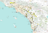
The 'Randsburg Quadrangle, San Bernardino and Kern Counties' file is part of the Grover Heinrichs mining collection. Grover was the Vice President of Heinrichs GEOEXploration, located in Tucson, Arizona. The collection contains over 1,400 folders including economic geology reports, maps, photos, correspondence, drill logs and other related materials. The focus of much of the information is on the western United States, particularly Arizona, but the collection also includes files on mining activity throughout the United States, foreign countries, and 82 mineral commodities.
Categories: Data;
Tags: California,
Dataset,
San Bernardino County,
United States,
geoscientificInformation,
|

|
