Filters: Tags: conservation (X)
1,069 results (71ms)|
Filters
Date Range
Extensions Types Contacts
Categories Tag Types
|

This study focuses on Endangered Forests and the biological components of the High Conservation Value Forest concept. High Conservation Value and Endangered Forests are identified and mapped based on several ecological components that are globally, regionally, or locally important. These ecological components can be landscape level features or biodiversity related. These components sometimes overlap and at other times are mutually exclusive. Any one component can be enough to identify a specific forest area as a High Conservation Value or Endangered Forest depending on the circumstance, but a full assessment using readily available spatial data of all of the ecological components is warranted before a forest is...
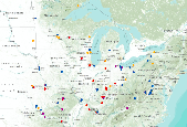
Distribution of Indigo Bunting adult captures at MAPS stations during the period 1992-2008 throughout Midwestern states (plus 250km buffer).

Breeding Bird Survey Relative Abundance for Acadian Flycatcher
Wood Thrush (Midwest) results from Midwest MAPS stations
Proportion of grassland land cover within a 5-km radius developed using a circular focal moving window analysis.
Categories: Data;
Types: Downloadable,
GeoTIFF,
Map Service,
Raster;
Tags: Colorado,
Idaho,
Montana,
United States,
Utah,
These data include egg mass counts and adult capture-mark-recapture histories for Foothill Yellow-legged frogs (Rana boylii) at two streams in northern California. Data were collected from the South Fork Eel River and its tributary, Fox Creek, from 1993-2019. Data from Hurdygurdy Creek were collected from 2002-2008.
Maintaining the native prairie lands of the Northern Great Plains (NGP), which provide an important habitat for declining grassland species, requires anticipating the effects of increasing atmospheric carbon dioxide (CO2) concentrations and climate change on the region’s vegetation. Specifically, climate change threatens NGP grasslands by increasing the potential encroachment of native woody species into areas where they were previously only present in minor numbers. This project used a dynamic vegetation model to simulate vegetation type (grassland, shrubland, woodland, and forest) for the NGP for a range of projected future climates and relevant management scenarios. Comparing results of these simulations illustrates...
Categories: Project;
Types: Map Service,
OGC WFS Layer,
OGC WMS Layer,
OGC WMS Service;
Tags: 2012,
Biology,
CASC,
Climate change,
Completed,
The Forest and Rangeland Ecosystem Science Center 's mission is to provide scientific understanding and the technology needed to support sound management and conservation of our nation's natural resources, with emphasis on western ecosystems. The scientists from FRESC capitalize on their diverse expertise to answer critically important scientific questions shaped by the equally diverse environments of the western United States. FRESC scientists collaborate with each other and with partners to provide rigorous, objective, and timely information and guidance for the management and conservation of biological systems in the West and worldwide. Research activities are concentrated in Washington, Oregon, Idaho, Nevada,...
The purpose of the Conservation Effects Assessment Project (CEAP) cropland national assessment is to quantify the environmental benefits of conservation programs at the regional and national levels, which include both onsite and instream water quality benefits. Modeling is an effective tool for environmental assessment at the regional and national scale due to the complexities in nature at this scale. Two simulation models, the Agricultural Policy Environmental extender (APEX) and the Soil and Water Assessment Tool (SWAT), were used for the CEAP cropland national assessment. A subset of National Resources Inventory (NRI) sample points was selected to serve as "representative fields" for the CEAP cropland survey...
Categories: Publication;
Types: Citation;
Tags: Agriculture,
Channels,
Conservation,
Data Visualization & Tools,
ENA 06:Food & Drugs,
This dataset represents the location and class density of potential annual grass risk within the Central Great Basin and Mojave Basin Ecoregion for the 2010 time period. This model represent a composite of multiple inductive (Maximum Entropy) models of varying annual grass cover using non-spectral landscape variables. Input Variables: elevation, aspect, distance to fire, geology, distance to hydric soils, distance to intermitant streams, landform, ombrotype, distance to perrenial streams, soil pH, density of primary roads, density of secondary/local roads, percent sandy soil, slope, thermotype. Classification of Model 0-No/Low Risk 1- < 5% Cover Risk 2- 5%-15% Cover Risk 3 - 15%-25% Cover Risk 4 - 25%-45% Cover...
A region polygon dataset categorizing land in terms of ecological significance and status of protection in the Central Basin and Range (CBR) Rapid Ecoregional Assessment. This dataset identifies lands that have been identified as ecologically significant to biodiveristy but not yet legally protected (Places I - Sites of High Biodiversity), lands that have some type of protection status, often federal or state (Places II - Specially Designated Areas of Ecological and/or Cultural Value), and lands that may be ecologically significant but are managed for multiple use (Places III – Other Managed Lands).
Types: Downloadable;
Tags: BLM,
Bureau of Land Management,
CBR 2010,
Central Basin and Range,
Conservation,
The dataset represents the work of multiple states and Federal agencies as part of the US Gap Analysis and LandFire programs. Multi-season satellite imagery (Landsat ETM+) from 1999-2001 were used in conjunction with digital elevation model (DEM) derived datasets (e.g. elevation, landform) to model natural and semi-natural vegetation. The minimum mapping unit for this dataset is approximately 1 acre. Landcover classes are drawn from NatureServe's Ecological System concept. Five-hundred and fourty-four land cover classes composed of 12 cultural and 532 Natural/Semi-natural types are described. Land cover classes were mapped with a variety of techniques including decision tree classifiers, terrian modeling, inductive...
The dataset represents the work of multiple states and Federal agencies as part of the US Gap Analysis and LandFire programs. Multi-season satellite imagery (Landsat ETM+) from 1999-2001 were used in conjunction with digital elevation model (DEM) derived datasets (e.g. elevation, landform) to model natural and semi-natural vegetation. The minimum mapping unit for this dataset is approximately 1 acre. Landcover classes are drawn from NatureServe's Ecological System concept. Five-hundred and fourty-four land cover classes composed of 12 cultural and 532 Natural/Semi-natural types are described. Land cover classes were mapped with a variety of techniques including decision tree classifiers, terrian modeling, inductive...
Ecoregions denote areas of general similarity in ecosystems and in the type, quality, and quantity of environmental resources. They are designed to serve as a spatial framework for the research, assessment, management, and monitoring of ecosystems and ecosystem components. These general purpose regions are critical for structuring and implementing ecosystem management strategies across federal agencies, state agencies, and nongovernment organizations that are responsible for different types of resources within the same geographical areas. The approach used to compile this map is based on the premise that ecological regions can be identified through the analysis of patterns of biotic and abiotic phenomena, including...
The dataset represents the work of multiple states and Federal agencies as part of the US Gap Analysis and LandFire programs. Multi-season satellite imagery (Landsat ETM+) from 1999-2001 were used in conjunction with digital elevation model (DEM) derived datasets (e.g. elevation, landform) to model natural and semi-natural vegetation. The minimum mapping unit for this dataset is approximately 1 acre. Landcover classes are drawn from NatureServe's Ecological System concept. Five-hundred and fourty-four land cover classes composed of 12 cultural and 532 Natural/Semi-natural types are described. Land cover classes were mapped with a variety of techniques including decision tree classifiers, terrian modeling, inductive...
This dataset was derived from 'NatureServe L48 ESLF V2.7'. See process steps for additional information. The dataset represents the work of multiple states and Federal agencies as part of the US Gap Analysis and LandFire programs. Multi-season satellite imagery (Landsat ETM+) from 1999-2001 were used in conjunction with digital elevation model (DEM) derived datasets (e.g. elevation, landform) to model natural and semi-natural vegetation. The minimum mapping unit for this dataset is approximately 1 acre. Landcover classes are drawn from NatureServe's Ecological System concept. Five-hundred and fourty-four land cover classes composed of 12 cultural and 532 Natural/Semi-natural types are described. Land cover classes...
The Gunnison sage-grouse (Centrocercus minimus) habitat suitability surface for Crawford satellite population represented here reflects summer season at a landscape scale context (window extents [radius] of 1 km, 3 km, and 6.4 km). Habitat suitability estimated for U.S. Fish and Wildlife Service critical habitat extent (southwestern Colorado). We developed habitat selection models for Gunnison sage-grouse (Centrocercus minimus), a threatened species under the U.S. Endangered Species Act. We followed a management-centric modeling approach that sought to balance the need to evaluate the consistency of key habitat conditions and improvement actions across multiple, distinct populations, while allowing context-specific...
Aspect is the compass direction toward which a slope faces, measured in degrees from North in a clockwise direction from 0 to 360. Aspect was generated using ArcGIS Spatial Analyst, with the USGS National Elevation Dataset as input. For quality information regarding the National Elevation Dataset, see http://nationalmap.gov/elevation.html. These data cover the entire continental U.S. and are a continuous data layer. These raster data have a 30 m x 30 m cell resolution. This aspect data set is considered official foundational data for the GAP species modeling process. The data have been made available provisionally to enhance understanding and use of GAP species data.
Types: Citation,
Map Service,
OGC WFS Layer,
OGC WMS Layer,
OGC WMS Service;
Tags: Aspect,
Biodiversity,
Conservation,
Topography,
United States
|

|
