Filters: Tags: cutthroat trout (X)
30 results (56ms)|
Filters
Date Range
Extensions Types Contacts
Categories Tag Types
|
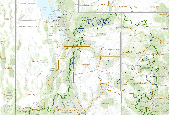
This map shows the potential current distribution of Colorado River Cutthroat Trout as well as current and near-term status, and long term potential for change (due to climate change).
Native fish of the Columbia River Basin, and the ecosystems that support them, are an innate and critical part of Nez Perce culture. The persistence of these fisheries may be at risk due to climate change, especially in combination with other stressors (e.g., habitat fragmentation and disconnectivity). Assessing vulnerability of these fisheries to climate change, considering options for action, and taking action will require strategic collaboration and coordination with multiple partners. Here, we propose to start building those partnerships to address this landscape-level conservation concern.The overarching philosophy of Nez Perce fisheries management is to ensure that all species and populations of anadromous...
Categories: Data,
Project;
Types: Map Service,
OGC WFS Layer,
OGC WMS Layer,
OGC WMS Service;
Tags: Bull Trout,
Climate Change,
Columbia Basin,
Conservation Planning,
Cutthroat Trout,
This project will support the design and development of a large-scale aquatics monitoring program across 1.5 million acres of the Crown of the Continent, as part of a 10-year, landscape-level restoration project established and funded by the U.S. Forest Service in 2010. The Forest Service has directed each of ten Cooperative Forest Landscape Restoration Program projects to develop and implement a large-scale monitoring program to inventory current resource conditions and facilitate the short- and long-term evaluation of the effectiveness of restoration projects to inform future management strategies and actions: the work proposed here would address significant challenges associated with maintaining or improving...
Categories: Data;
Types: Map Service,
OGC WFS Layer,
OGC WMS Layer,
OGC WMS Service;
Tags: Bull Trout,
Climate Change,
Completed,
Cutthroat Trout,
Goal 3: Maintain hydrologic regimes,
This project will support the design and development of a large-scale aquatics monitoring program across 1.5 million acres of the Crown of the Continent, as part of a 10-year, landscape-level restoration project established and funded by the U.S. Forest Service in 2010. The Forest Service has directed each of ten Cooperative Forest Landscape Restoration Program projects to develop and implement a large-scale monitoring program to inventory current resource conditions and facilitate the short- and long-term evaluation of the effectiveness of restoration projects to inform future management strategies and actions: the work proposed here would address significant challenges associated with maintaining or improving...
Categories: Data,
Project;
Types: Map Service,
OGC WFS Layer,
OGC WMS Layer,
OGC WMS Service;
Tags: Bull Trout,
Climate Change,
Cutthroat Trout,
Federal resource managers,
Goal 3: Maintain hydrologic regimes,
Existing stream temperature data were compiled from numerous federal, state, tribal, and private sources to develop an integrated regional database. Spatial statistical models for river networks were applied to these data to develop an accurate model that predicts stream temperature for all fish-bearing streams in the US portion of the GNLCC. Differences between model outputs for historic and future climate scenarios were used to assess spatial variation in the vulnerability of sensitive fish species across the GNLCC.FY2011Objectives: Develop a regional stream temperature model that incorporates important climate drivers, wildfire/riparian conditions, and geomorphic factors; Use the model to understand and predict...
Categories: Data,
Project;
Types: Map Service,
OGC WFS Layer,
OGC WMS Layer,
OGC WMS Service;
Tags: Academics & scientific researchers,
Aquatic Connectivity,
British Columbia,
Bull Trout,
CA-1,
We propose a regional assessment of aquatic species vulnerabilities and responses to climate change as the basis for adaptive management for aquatic ecosystems in the Great Northern LCC, using the Transboundary Flathead Ecosystem as a case example. This region encompasses a complex mix of federal, state, tribal, and private lands in the US and federal, provincial and private lands in Canada. The complex suite of ownerships, international relations, and agency objectives establish their own set of challenges; however, all will experience a similar range of climatic (e.g., long-term drought and declining snow pack) and non-climatic (e.g., habitat fragmentation, shifting land- and water use patterns, and invasive species)...
Categories: Data,
Project;
Types: Map Service,
OGC WFS Layer,
OGC WMS Layer,
OGC WMS Service;
Tags: Alberta,
Applications and Tools,
Aquatic Ecosystems,
British Columbia,
Bull Trout,
This data set characterizes the thermal regime in a number of Colorado and New Mexico streams that contain populations of Rio Grande Cutthroat Trout (Oncorhynchus clarkii virginalis) or have been considered potential restoration areas for the fish. The majority of these streams had no previous record of continual temperature records. When compared to Colorado water temperature criteria (Cold Tier 1), a portion of these populations appeared to be at risk from elevated stream temperatures, as indicated by exceedance of both acute and chronic water quality metrics. Summer water temperature profiles recorded at sites within current Rio Grande Cutthroat Trout habitat indicated that although the majority of currently...
Categories: Data;
Types: Citation,
Map Service,
OGC WFS Layer,
OGC WMS Layer,
OGC WMS Service;
Tags: Air Temperature,
Aquatic Biology,
Birds,
Colorado,
Cutthroat Trout,
Funding supports a multiyear initiative entitled Crown of the Continent Landscapes Analysis/Ecological Indicators Project. The work is designed to focus on issues on transboundary data integration and synthesis, habitatconnectivity analysis for grizzly bears (Ursus arctos) and other key wildlife species, and outreach programs aimed at disseminating knowledge, information products, and geospatial tools arising out of this work to the extensive network of Crown Managers Partnership (CMP) and GNLCC collaborators.FY2010Objectives:The monitoring strategy will focus on the development and acquisition of geospatial datasets from remote sensing and other GIS sources designed to track changes in habitats and human footprint...
Categories: Data,
Project;
Types: Map Service,
OGC WFS Layer,
OGC WMS Layer,
OGC WMS Service;
Tags: Alberta,
Alberta,
British Columbia,
British Columbia,
Bull Trout,
Workshop goals were to gather a diverse group of researchers and management professionals to focus on three objectives: Sharing current information regarding the effects of climate change on aquatic ecosystems Presenting analysis tools that could assist managers in addressing climate change Discussing management implications of climate change, the utility of existing tools, and future information & analysis needs
Categories: Data,
Project;
Types: Map Service,
OGC WFS Layer,
OGC WMS Layer,
OGC WMS Service;
Tags: Academics & scientific researchers,
Alberta,
Aquatic Connectivity,
British Columbia,
Bull Trout,
For the Green River Basin Landscape Conservation Design (GRB LCD) assessment, we mapped the vulnerability of occupied Colorado River cutthroat trout (Oncorhynchus clarkii pleuriticus) habitat to climate change for each 12-digit hydrologic unit. Cutthroat trout occupied habitat was mapped from the range-wide status report (Hirsch et. al 2013). Using a vulnerability framework, we defined Sensitivity (S) as the total length of occupied cutthroat trout habitat within HUC12 polygons. The exposure parameter incorporates two climate change metrics, the change in flow timing and change in stream temperature. Exposure is quantified as the square root transformed product of the two climate change metrics. Potential Impact...
Categories: Data;
Types: ArcGIS REST Map Service,
ArcGIS Service Definition,
Downloadable,
Map Service,
OGC WFS Layer,
OGC WMS Layer,
Shapefile;
Tags: Colorado,
Colorado,
EARTH SCIENCE > LAND SURFACE > LANDSCAPE,
Green River Basin,
Green River Basin,
|

|
